|
|
|
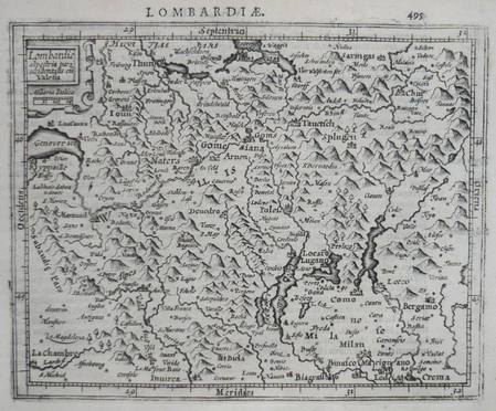
MERCATOR (Gerard);HONDIUS (Jodocus);
[LOMBARDIE] Lombardiae alpestris pars occidentalis cum Valesia.
Dordrecht Adrianus Bottius 1610 149 x 179 mm.
書籍販売業者の参照番号
: LBW0616d
|
|
|
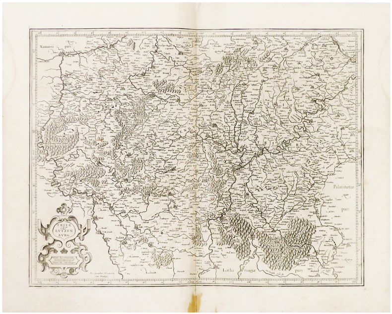
MERCATOR (Gerard).
[LUXEMBOURG] Trier & Lutzenburg.
[Amsterdam, 1603-1622]. 366 x 474 mm.
書籍販売業者の参照番号
: LBW04179
|
|
|
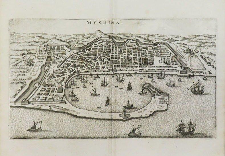
MERIAN (Matthäus).
[MESSINE] Messina.
[1649]. 203 x 350 mm.
書籍販売業者の参照番号
: LBW-3477
|
|
|
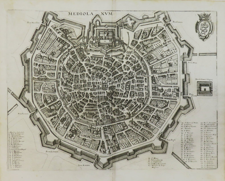
MERIAN (Matthäus).
[MILAN] Mediolanum.
[1649]. 267 x 351 mm.
書籍販売業者の参照番号
: LBW-3590
|
|
|
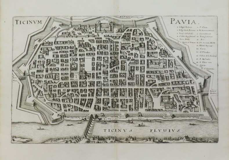
MERIAN (Matthäus).
[PAVIE] Ticinum - Pavia.
[1649]. 217 x 343 mm.
書籍販売業者の参照番号
: LBW-3591
|
|
|
MERIAN (Matthäus).
[PALERME] Panormo.
[1649]. 300 x 381 mm.
書籍販売業者の参照番号
: LBW-3589

|
|
|
MERIAN (Matthäus).
[PARME] Parma.
[1649]. 282 x 360 mm.
書籍販売業者の参照番号
: LBW-3469

|
|
|
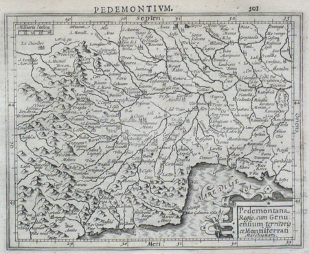
MERCATOR (Gerard);HONDIUS (Jodocus);
[PIEMONT] Pedemontana regio, cum Genuensium territorio et Montifferrati marchionatu.
Dordrecht Adrianus Bottius 1610 147 x 178 mm.
書籍販売業者の参照番号
: LBW0616e
|
|
|
MERCATOR (Gerard);HONDIUS (Jodocus);
[POUILLES/CALABRE] Puglia Piana terra di Barri Otrato etc.
Dordrecht Adrianus Bottius 1610 134 x 177 mm.
書籍販売業者の参照番号
: LBW0618c

|
|
|
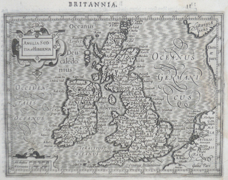
MERCATOR (Gerard) & HONDIUS (Jodocus).
[ROYAUME-UNI] Anglia Scotia et Hibernia.
[Dordrecht, Adrianus Bottius, 1610]. 142 x 178 mm.
書籍販売業者の参照番号
: LBW0615d
|
|
|
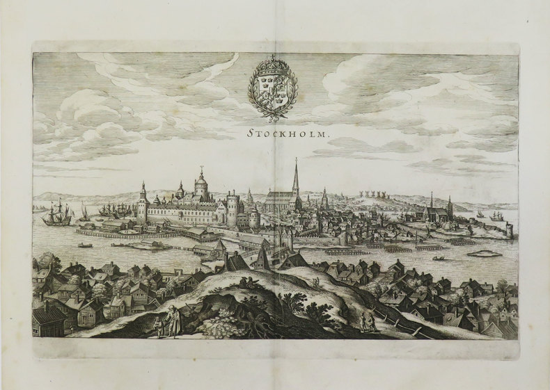
MERIAN (Matthäus).
[SUEDE] Stockholm.
[1649]. 194 x 330 mm.
書籍販売業者の参照番号
: LBW-3596
|
|
|
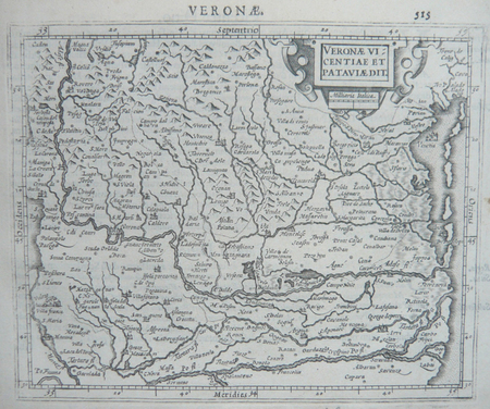
MERCATOR (Gerard);HONDIUS (Jodocus);
[VERONE] Veronae Vicentiae et Pataviae dit.
Dordrecht Adrianus Bottius 1610 150 x 178 mm.
書籍販売業者の参照番号
: LBW06170
|
|
|
Merel-Brandenburg
baptistere Saint-Jean au sein du groupe episcopal du Puy-en-Velay
, Brepols Publishers, 2018 Paperback, Illustrated, French, English, 352 pagina's. ISBN 9782503570280.
書籍販売業者の参照番号
: 51644
|
|
|
MERZ (Walther) [verfasst von]
Die Habsburg. Studie, im Auftrag der h. Baudirektion des Kantons Aargau.
Aarau und Leipzig, Emil Wirz, 1896. In-8 broché, VII-100 pp., 20 planches de plans et reprod. en noir, dont 5 tableaux généalogiques dépliants, 31 fig. en noir dans le texte.
書籍販売業者の参照番号
: 503538
|
|
|
MERIAN, Marie Sybille de (1647-1717) & BUC'HOZ (Buchoz), (Pierre Joseph) (1731-1807):
Histoire générale des Insectes de Surinam et de toute l'Europe. 3e édition, revue, corrigée, & augmentée par M. Buchoz, ... à laquelle on a joint une 3ème volume, (en 2 parties), qui traite des plus belles fleurs, telles que des plantes bulbeuses, liliacées, caryophyllées, &c. avec leur description exacte, leur culture, & leurs propriétés’,
Paris, L.C. Desnos, 1771, gr. in-folio, Avec 116 gravures de fleurs dans un brillant coloris plus récent. 1 f. + 69 p.; 1 f. + 72 p., Maroquin rouge du XIXème siècle, dos refait.
書籍販売業者の参照番号
: 67644aaf
|
|
|
MERMET (M.)
Histoire de la ville de Vienne de l'an 1040 à 1801.
Vienne, Grenoble, Lyon et Paris, 1854. In-8 br., non rogné, portrait-front., VII-535 pp. Couv. usagée, dos renforcé, mouillure marginale sur les derniers ff.
書籍販売業者の参照番号
: 574683
|
|
|
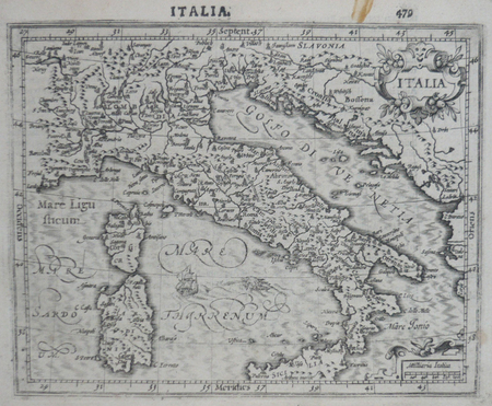
MERCATOR (Gerard);HONDIUS (Jodocus);
Italia.
Dordrecht Adrianus Bottius 1610 150 x 182 mm.
書籍販売業者の参照番号
: LBW0616c
|
|
|
MERLIN Louis
J'en ai vu des choses. 1900 - 1939. (Tome 1 seul).
Couverture souple. Broché. 462 pages. Jaquette plastifiée (bibliothèque).
書籍販売業者の参照番号
: 78136
|
|
|
MERLIN Louis
J'en ai vu des choses. 1900 - 1939. (Tome 1 seul).
Couverture souple. Broché. 462 pages. Jaquette.
書籍販売業者の参照番号
: 123640

|
|
|
MERIMEE (Prosper)]
La Guzla ou choix de poésies illyriques. Recueillies dans la Dalmatie, la Bosnie, la Croatie et l'Herzégovine.
Paris Levrault 1827 1 vol. Relié in-18, bradel demi-maroquin vert à coins, couvertures et dos conservés, non rogné, XII + 257 pp. Édition originale ornée d'une belle gravure en frontispice. Parue anonymement à l'instar du Théâtre de Clara Gazul, La Guzla est un recueil de ballades attribuées au musicien-poète Hyacinthe Maglanovitch et qui sont censées fixer un folklore "Illyrien". Mais la part d'invention de Mérimée semble évidente dès la présentation burlesque de la vie de ce troubadour des Balkans, et on y trouve aussi le fameux chapitre "Sur le vampirisme" et la chanson de Cara-Ali le vampire... Quelques rousseurs, sinon bel exemplaire en reliure pastiche avec les couvertures d'origine conservées. Ex-libris gravé P. François.
書籍販売業者の参照番号
: 47318
|
|
|
MERRUAU Paul
Les marines secondaires de la Baltique et de la mer du nord
La Revue des deux mondes, Paris 1877, 15,5x25cm, agrafé.
書籍販売業者の参照番号
: 20078
|
|
|
MERTENS (Charles)
Les fastes du Brabant. Le château féodal de Beersel et ses seigneurs.
Bruxelles, Editions Historia, 1942. In-8 br., 154 pp., nombr. ill.
書籍販売業者の参照番号
: 579094
|
|
|
Mercure de France Politique, Historique et Littéraire
Mercure de France Politique, Historique et Littéraire (Politique de l'Europe)
12 Numéros In-12 - Brochés - Environ 50 pages par fascicules -N°38 à 42 du 16/09/1780 au14/10/1780 -N° 45 à49 du 4/11/1780 au 2/12/1780 - 51 & 52 du 16/12au 23/12/1780 - rousseurs d'usage - Envoi rapide et soigné
書籍販売業者の参照番号
: 46020
|
|
|
Merveilles des Palais Italiens.
Merveilles des palais italiens.
hachette realite 1968 In-4 relié. Bon état d’occasion. Jaquette abîmée avec des manques.
書籍販売業者の参照番号
: 60227
|
|
|
MERIMEE Prosper
Épisode de l'Histoire de Russie - Les Faux Démétrius - Édition originale.
Édition originale. Paris, Michel Lévy Frères - 1853 - 448 pages.Reliure demi basane de l'époque. Dos lisse orné de filets dorés, avec titre, et auteur. Rousseurs. Assez bon état. Format in-12°(18x12).
書籍販売業者の参照番号
: 18984
|
|
|
MERIMEE Prosper
Épisode de l'Histoire de Russie - Les Faux Démétrius - Édition originale.
Édition originale. Paris, Michel Lévy Frères - 1853 - 452 pages.Belle reliure demi maroquin brun à coins signée L. Issac. Dos à nerfs orné et richement doré. Tête dorée sur témoins, non rogné. Filet doré bordant les plats. Couverture et dos conservés. Signet. Rousseurs pales. Très bon état. Format in-12°(19x13).
書籍販売業者の参照番号
: 15294

|
|
|
Meras Phyllis
The Mermaids of Chenonceaux and 828 Other Stories: An Anecdotal Guide to Europe
<p>New York: Congdon & Weed 1983 1st ed. 336pp. putty and brown cloth 8vo: near Very Good in a Very Good dj edges show age foxing; some browning of endpp; else a nice clean complete & tight copy</p> New York: Congdon & Weed hardcover
書籍販売業者の参照番号
: 23982 ISBN : 0312925255 9780312925253

|
|
|
Meras Phyllis
The Mermaids of Chenonceaux: And 828 Other Stories: An Anecdotal Guide to Europe
New York New York USA and Ontario Canada: Congdon & Weed Inc and Beaverbooks Ltd 1983. Paperback. Very Good/No Jacket. Trade Paperback in Very Good Condition. A new approach to travel writing-delightful and interesting for the goers and the armchair travelers. A perfect companion to traditional travel guides and wonderful reading as well. Clean and unmarked blue wraps illustrated slight wear to extremities; no creasing; tight & solid. pages evenly toned clean no markings of any kind. xii 336 pages indexed. 5.5 x 8.25 inches. 1983 Congdon & Weed Inc and Beaverbooks Ltd New York New York USA and Ontario Canada Congdon & Weed, Inc and Beaverbooks, Ltd paperback
書籍販売業者の参照番号
: 024070 ISBN : 0865531595 9780865531598

|
|
|
MERCATOR (Kremer) Gerard (1512 - 1594)
Cornubia, Devonia, Somersetus, Dorcestria, Wiltonia …
La carta del Sud-Ovest dell'Inghilterra e del Galles; include i territori di Cornovaglia, Devon, Sommerset, Dorset, Wilton, Glouchester, Glamorgan, Caermarden, Penbroke, Cardigan, Radnor Breknoke, Hereford e Wigorn. La carta viene preparata da Gerard Mercator per l’Atlantis Pars Altera (1595) pubblicato postumo alla morte dell’autore, sotto la supervisione del figlio Rumold Mercator, dallo stampatore di Duisburg Albert Buys. Composto da sei parti – pubblicate separatamente tra il 1589 e il 1594 – comprende 107 mappe, tutte tranne la carta del mondo di Rumold, firmate da Gerard Mercator. Le lastre vennero poi acquistate da Jodocus Hondius, che tra il 1606 e il 1630 le utilizzò per il suo Atlas Sive Cosmographicae Meditationes de Fabrica Mundi, integrandole ed aggiornandole con proprie “nuove” carte. Delle mappe di Mercator sono note anche ristampe curate da Johannes Janssonius. Le edizioni Hondius e Janssonius ebbero un grande successo commerciale e furono stampate in più lingue, con il testo al verso della carta in latino, francese, tedesco e olandese. La carta è incisa con i connotati tipici dell'opera mercatoriana. Le montagne sono allineate in un concetto di area montuosa, non per indicare vere catene o valli, ed hanno una struttura con qualche differenza nella dimensione, ma simile per quanto riguarda la forma, con pendici verticali e cime piatte. Le città sono mostrate attraverso castelli più o meno grandi caratterizzati da tetti slanciati ed aguzzi, simili a cappelli di mago. Esemplare tratto da Atlas Sive Cosmographicae Meditationes de Fabrica Mundi di Jodocus Hondius. Incisione in rame, in buono stato di conservazione. Bibliografia cfr. Koeman II Me 11 e Koeman II Me 13A, 1595); Van der Krogt 1:002; J. Keuning, The History of an Atlas, in “Imago Mundi” IV (1947) pp. 37-43; World Encompassed p. 134. A reissue of Mercator's regional map of South-West England by Hondius, in which the original cartouche has been replaced and Mercator's name erased. Includes the countries of Cornwall, Devon, Sommerset, Dorset, Wilton, Glouchester, Glamorgan, Caermarden, Penbroke, Cardigan, Radnor Breknoke, Hereford and Wigorn. The map is prepared by Gerard Mercator for his Atlantis Pars Altera (1595) published posthumously after the death of Mercator, by the Duisburg printer Albert Buys, under the supervision of his son Rumold Mercator. Composed of six parts - published separately between 1589 and 1594 - it includes 107 maps, all except Rumold's map of the world, made by Gerard Mercator. The plates were then purchased by Jodocus Hondius, who between 1606 and 1630 used them for his Atlas Sive Cosmographicae Meditationes de Fabrica Mundi, integrating and updating them with his own "new" maps. Of Mercator's maps are also known reprints edited by Johannes Janssonius. The Hondius and Janssonius editions had a great commercial success and were printed in several languages, with the text on the back of the map in Latin, French, German and Dutch. The map is engraved with the typical connotations of Mercatorian work. The mountains are aligned in a mountainous area concept, not to indicate true chains or valleys, and have a structure with some differences in size, but similar in shape, with vertical slopes and flat tops. The cities are shown through more or less large castles characterized by slender and pointed roofs, similar to wizard hats. Example from Atlas Sive Cosmographicae Meditationes de Fabrica Mundi by Jodocus Hondius. Copper engraving, in good condition. Bibliografia cfr. Koeman II Me 11 e Koeman II Me 13A, 1595); Van der Krogt 1:002; J. Keuning, The History of an Atlas, in “Imago Mundi” IV (1947) pp. 37-43; World Encompassed p. 134.

|
|
|
MERCATOR (Kremer) Gerard (1512 - 1594)
EUR: VIII TAB: (Europae Tabula Octava)
Carta tolemaica dell'antica regione della Sarmazia corrispondente all'attuale territorio di Ucraina e Russia. Mappa tratta dal Cl. Ptolemaei Alexandrini, Geographiae Libri Octo, pubblicata prima a Colonia da Gottfried von Kempen (1578) e poi ristampata dallo stesso editore nel 1584 (Van der Krogt 1, 502) e poi da Isaac Elsevier per il Theatrum Geographiae veteris di Petrus Bertius (Leyden 1618). Di tutte le edizioni di Tolomeo, quella di Gerard Kremer (Mercatore), pubblicata nel 1578, e forse tecnicamente la più bella. A questo punto la Geografia di Tolomeo perdeva però ogni pretesa di “attualità”, laddove lo scopo di Mercatore era quello di produrre un atlante del mondo classico che servisse da complemento al suo atlante moderno (per tale ragione egli aveva tentato di recuperare la forma originale dell’atlante tolemaico, scartandone le moderne accrezioni). L'interpretazione di Mercatore del testo tolemaico, per le 28 carte che illustrano la sua Geographia è stata, quindi, una delle più veritiere. Egli aveva passato 13 anni a ricercare, disegnare e incidere le carte, rinunciando anche alla pubblicazione delle sue carte “moderne”. Questo esemplare proviene dal Theatrum Geographia Veteris di Petrus Bertius edita a Leida nel 1618, che combina il Tolomeo di Mercator, le 8 tavole del Moretus per rappresentare la Tabula Peutingeriana e 14 mappe storiche delle regioni d'Europa derivate dal Parergon di Ortelius. Acquaforte su rame, in buone condizioni. Ptolemaic map of ancient Sarmatia the region between the Baltic, Adriatic and Black Seas. Map taken from the Cl. Ptolemaei Alexandrini, Geographiae Libri Octo, first published in Cologne by Gottfried von Kempen (1578) and then reprinted by the same publisher in 1584 (Van der Krogt 1, 502) and then by Isaac Elsevier for the Petrus Bertius’ Theatrum Geographiae veteris (Leyden 1618). Mercator's interpretation of the 28 Ptolemaic text was possibly one of the truest undertaken up until that time. He had spent 13 years researching, drawing and engraving the maps at much commercial sacrifice to himself, having seen Ortelius's Theatrum and De Jodes Speculum published, to become both technical and commercial successes. In later life he devoted himself to his edition of the maps in Ptolemy's Geographia, reproduced in his own engraving as nearly as possible in their original form. This example comes from the Theatrum Geographia Veteris of Petrus Bertius published in Leiden in 1618, which combines Mercator's Ptolemy, the 8 plates of Moretus to represent the Tabula Peutingeriana and 14 historical maps of the regions of Europe derived from the Parergon of Ortelius. Copperplate, in good condition.

|
|
|
MERCATOR (Kremer) Gerard (1512 - 1594)
Europa III Tab
Mappa tratta dal Cl. Ptolemaei Alexandrini, Geographiae Libri Octo, pubblicata prima a Colonia da Gottfried von Kempen (1578) e poi ristampata dallo stesso editore nel 1584 (Van der Krogt 1, 502) e poi da Isaac Elsevier per il Theatrum Geographiae veteris di Petrus Bertius (Leyden 1618). Di tutte le edizioni di Tolomeo, quella di Gerard Kremer (Mercatore), pubblicata nel 1578, e forse tecnicamente la più bella. A questo punto la Geografia di Tolomeo perdeva però ogni pretesa di “attualità”, laddove lo scopo di Mercatore era quello di produrre un atlante del mondo classico che servisse da complemento al suo atlante moderno (per tale ragione egli aveva tentato di recuperare la forma originale dell’atlante tolemaico, scartandone le moderne accrezioni). L'interpretazione di Mercatore del testo tolemaico, per le 28 carte che illustrano la sua Geographia è stata, quindi, una delle più veritiere. Egli aveva passato 13 anni a ricercare, disegnare e incidere le carte, rinunciando anche alla pubblicazione delle sue carte “moderne”. Questo esemplare proviene dal Theatrum Geographia Veteris di Petrus Bertius edita a Leida nel 1618, che combina il Tolomeo di Mercator, le 8 tavole del Moretus per rappresentare la Tabula Peutingeriana e 14 mappe storiche delle regioni d'Europa derivate dal Parergon di Ortelius. Acquaforte su rame, in buone condizioni. Map taken from the Cl. Ptolemaei Alexandrini, Geographiae Libri Octo, first published in Cologne by Gottfried von Kempen (1578) and then reprinted by the same publisher in 1584 (Van der Krogt 1, 502) and then by Isaac Elsevier for the Petrus Bertius’ Theatrum Geographiae veteris (Leyden 1618). Mercator's interpretation of the 28 Ptolemaic text was possibly one of the truest undertaken up until that time. He had spent 13 years researching, drawing and engraving the maps at much commercial sacrifice to himself, having seen Ortelius's Theatrum and De Jodes Speculum published, to become both technical and commercial successes. In later life he devoted himself to his edition of the maps in Ptolemy's Geographia, reproduced in his own engraving as nearly as possible in their original form. This example comes from the Theatrum Geographia Veteris of Petrus Bertius published in Leiden in 1618, which combines Mercator's Ptolemy, the 8 plates of Moretus to represent the Tabula Peutingeriana and 14 historical maps of the regions of Europe derived from the Parergon of Ortelius. Copperplate, in good condition.

|
|
|
MERCATOR (Kremer) Gerard (1512 - 1594)
Europa IIII Tab.
Mappa tratta dal Cl. Ptolemaei Alexandrini, Geographiae Libri Octo, pubblicata prima a Colonia da Gottfried von Kempen (1578) e poi ristampata dallo stesso editore nel 1584 (Van der Krogt 1, 502) e poi da Isaac Elsevier per il Theatrum Geographiae veteris di Petrus Bertius (Leyden 1618). Di tutte le edizioni di Tolomeo, quella di Gerard Kremer (Mercatore), pubblicata nel 1578, e forse tecnicamente la più bella. A questo punto la Geografia di Tolomeo perdeva pero ogni pretesa di “attualità”, laddove lo scopo di Mercatore era quello di produrre un atlante del mondo classico che servisse da complemento al suo atlante moderno (per tale ragione egli aveva tentato di recuperare la forma originale dell’atlante tolemaico, scartandone le moderne accrezioni). L'interpretazione di Mercatore del testo tolemaico, per le 28 carte che illustrano la sua Geographia è stata, quindi, una delle più veritiere. Egli aveva passato 13 anni a ricercare, disegnare e incidere le carte, rinunciando anche alla pubblicazione delle sue carte “moderne”. Acquaforte su rame, in buone condizioni. Map taken from the Cl. Ptolemaei Alexandrini, Geographiae Libri Octo, first published in Cologne by Gottfried von Kempen (1578) and then reprinted by the same publisher in 1584 (Van der Krogt 1, 502) and then by Isaac Elsevier for the Petrus Bertius’ Theatrum Geographiae veteris (Leyden 1618). Mercator's interpretation of the 28 Ptolemaic text was possibly one of the truest undertaken up until that time. He had spent 13 years researching, drawing and engraving the maps at much commercial sacrifice to himself, having seen Ortelius's Theatrum and De Jodes Speculum published, to become both technical and commercial successes. In later life he devoted himself to his edition of the maps in Ptolemy's Geographia, reproduced in his own engraving as nearly as possible in their original form. Copperplate, in good condition.

|
|
|
MERCATOR (Kremer) Gerard (1512 - 1594)
EUROPAE I TAB
Mappa tratta dal Cl. Ptolemaei Alexandrini, Geographiae Libri Octo, pubblicata prima a Colonia da Gottfried von Kempen (1578) e poi ristampata dallo stesso editore nel 1584 (Van der Krogt 1, 502) e poi da Isaac Elsevier per il Theatrum Geographiae veteris di Petrus Bertius (Leyden 1618). Di tutte le edizioni di Tolomeo, quella di Gerard Kremer (Mercatore), pubblicata nel 1578, e forse tecnicamente la più bella. A questo punto la Geografia di Tolomeo perdeva però ogni pretesa di “attualità”, laddove lo scopo di Mercatore era quello di produrre un atlante del mondo classico che servisse da complemento al suo atlante moderno (per tale ragione egli aveva tentato di recuperare la forma originale dell’atlante tolemaico, scartandone le moderne accrezioni). L'interpretazione di Mercatore del testo tolemaico, per le 28 carte che illustrano la sua Geographia è stata, quindi, una delle più veritiere. Egli aveva passato 13 anni a ricercare, disegnare e incidere le carte, rinunciando anche alla pubblicazione delle sue carte “moderne”. Questo esemplare proviene dal Theatrum Geographia Veteris di Petrus Bertius edita a Leida nel 1618, che combina il Tolomeo di Mercator, le 8 tavole del Moretus per rappresentare la Tabula Peutingeriana e 14 mappe storiche delle regioni d'Europa derivate dal Parergon di Ortelius. Acquaforte su rame, in buone condizioni. Ptolemaic map of British Isles. Showing landmarks, major cities and towns, rivers and parks. The map is decorated with a strapwork title cartouche, a sea monster and a fishing scene in the North Sea. Map taken from the Cl. Ptolemaei Alexandrini, Geographiae Libri Octo, first published in Cologne by Gottfried von Kempen (1578) and then reprinted by the same publisher in 1584 (Van der Krogt 1, 502) and then by Isaac Elsevier for the Petrus Bertius’ Theatrum Geographiae veteris (Leyden 1618). Mercator's interpretation of the 28 Ptolemaic text was possibly one of the truest undertaken up until that time. He had spent 13 years researching, drawing and engraving the maps at much commercial sacrifice to himself, having seen Ortelius's Theatrum and De Jodes Speculum published, to become both technical and commercial successes. In later life he devoted himself to his edition of the maps in Ptolemy's Geographia, reproduced in his own engraving as nearly as possible in their original form. This example comes from the Theatrum Geographia Veteris of Petrus Bertius published in Leiden in 1618, which combines Mercator's Ptolemy, the 8 plates of Moretus to represent the Tabula Peutingeriana and 14 historical maps of the regions of Europe derived from the Parergon of Ortelius. Copperplate, in good condition.

|
|
|
MERCATOR (Kremer) Gerard (1512 - 1594)
EUROPAE V TABULA
Carta tolemaica incentrata sulle antiche provincie romane della Rezia, Norico, Pannonia e Illiria, lungo la costa adriatica. Mappa tratta dal Cl. Ptolemaei Alexandrini, Geographiae Libri Octo, pubblicata prima a Colonia da Gottfried von Kempen (1578) e poi ristampata dallo stesso editore nel 1584 (Van der Krogt 1, 502) e poi da Isaac Elsevier per il Theatrum Geographiae veteris di Petrus Bertius (Leyden 1618). Di tutte le edizioni di Tolomeo, quella di Gerard Kremer (Mercatore), pubblicata nel 1578, e forse tecnicamente la più bella. A questo punto la Geografia di Tolomeo perdeva però ogni pretesa di “attualità”, laddove lo scopo di Mercatore era quello di produrre un atlante del mondo classico che servisse da complemento al suo atlante moderno (per tale ragione egli aveva tentato di recuperare la forma originale dell’atlante tolemaico, scartandone le moderne accrezioni). L'interpretazione di Mercatore del testo tolemaico, per le 28 carte che illustrano la sua Geographia è stata, quindi, una delle più veritiere. Egli aveva passato 13 anni a ricercare, disegnare e incidere le carte, rinunciando anche alla pubblicazione delle sue carte “moderne”. Questo esemplare proviene dal Theatrum Geographia Veteris di Petrus Bertius edita a Leida nel 1618, che combina il Tolomeo di Mercator, le 8 tavole del Moretus per rappresentare la Tabula Peutingeriana e 14 mappe storiche delle regioni d'Europa derivate dal Parergon di Ortelius. Acquaforte su rame, in buone condizioni. Ptolemaic map of the Roman Empire' provinces of Raetia, Noricum, Illyria, Noricum. Map taken from the Cl. Ptolemaei Alexandrini, Geographiae Libri Octo, first published in Cologne by Gottfried von Kempen (1578) and then reprinted by the same publisher in 1584 (Van der Krogt 1, 502) and then by Isaac Elsevier for the Petrus Bertius’ Theatrum Geographiae veteris (Leyden 1618). Mercator's interpretation of the 28 Ptolemaic text was possibly one of the truest undertaken up until that time. He had spent 13 years researching, drawing and engraving the maps at much commercial sacrifice to himself, having seen Ortelius's Theatrum and De Jodes Speculum published, to become both technical and commercial successes. In later life he devoted himself to his edition of the maps in Ptolemy's Geographia, reproduced in his own engraving as nearly as possible in their original form. This example comes from the Theatrum Geographia Veteris of Petrus Bertius published in Leiden in 1618, which combines Mercator's Ptolemy, the 8 plates of Moretus to represent the Tabula Peutingeriana and 14 historical maps of the regions of Europe derived from the Parergon of Ortelius. Copperplate, in good condition.

|
|
|
MERCATOR (Kremer) Gerard (1512 - 1594)
Forum Iulium, Karstia, Carniola, Histria et Windorum Marchia
Mappa regionale dettagliata delle regioni del Golfo di Venezia e del Golfo di Trieste, che comprende Friuli e Istria. Include la Slovenia, la Croazia nordoccidentale e parti dell'Italia e dell'Austria. La carta viene preparata da Gerard Mercator per il suo Italia, Sclavoniae et Graeciae tabula geographicae (Duisburg, 1589) che comprende un frontespizio allegorico e 22 carte geografiche della penisola, dei Balcani e della Grecia. Successivamente le carte sono ristampate nell’Atlantis Pars Altera (1595) pubblicato postumo alla morte del Mercatore, dallo stampatore di Duisburg Albert Buys, sotto la supervisione del figlio Rumold Mercator. Composto da sei parti – pubblicate separatamente tra il 1589 e il 1594 – comprende 107 mappe, tutte tranne la carta del mondo di Rumold, firmate da Gerard Mercator. Le lastre vennero poi acquistate da Jodocus Hondius, che tra il 1606 e il 1630 le utilizzò per il suo Atlas Sive Cosmographicae Meditationes de Fabrica Mundi, integrandole ed aggiornandole con proprie “nuove” carte. Delle mappe di Mercator sono note anche ristampe curate da Johannes Janssonius. Le edizioni Hondius e Janssonius ebbero un grande successo commerciale e furono stampate in più lingue, con il testo al verso della carta in latino, francese, tedesco e olandese. La carta è incisa con i connotati tipici dell'opera mercatoriana. Le montagne sono allineate in un concetto di area montuosa, non per indicare vere catene o valli, ed hanno una struttura con qualche differenza nella dimensione, ma simile per quanto riguarda la forma, con pendici verticali e cime piatte. Le città sono mostrate attraverso castelli più o meno grandi caratterizzati da tetti slanciati ed aguzzi, simili a cappelli di mago. Esemplare tratto da Atlas Sive Cosmographicae Meditationes de Fabrica Mundi di Jodocus Hondius. Acquaforte e bulino. Magnifica prova, impressa su carta vergata coeva, con margini, coloritura coeva, piccole ossidazioni, per il resto in perfetto stato di conservazione. Bibliografia cfr. Koeman II Me 11 e Koeman II Me 13A, 1595); Van der Krogt 1:002; J. Keuning, The History of an Atlas, in “Imago Mundi” IV (1947) pp. 37-43; World Encompassed p. 134. Detailed regional map of the Gufl of Venice and Gulf of Trieste regions, including Friuli and Istria. Includes Slovenia, northwestern Croatia and parts of Italy and Austria. The map is prepared by Gerard Mercator for his Italia, Sclavoniae et Graeciae tabula geographicae (Duisburg, 1589), which includes an allegorical frontispiece and 22 maps of Italy, the Balkans and Greece. Later, the maps are reprinted in the Atlantis Pars Altera (1595) published posthumously after the death of Mercator, by the Duisburg printer Albert Buys, under the supervision of his son Rumold Mercator. Composed of six parts - published separately between 1589 and 1594 - it includes 107 maps, all except Rumold's map of the world, made by Gerard Mercator. The plates were then purchased by Jodocus Hondius, who between 1606 and 1630 used them for his Atlas Sive Cosmographicae Meditationes de Fabrica Mundi, integrating and updating them with his own "new" maps. Of Mercator's maps are also known reprints edited by Johannes Janssonius. The Hondius and Janssonius editions had a great commercial success and were printed in several languages, with the text on the back of the map in Latin, French, German and Dutch. The map is engraved with the typical connotations of Mercatorian work. The mountains are aligned in a mountainous area concept, not to indicate true chains or valleys, and have a structure with some differences in size, but similar in shape, with vertical slopes and flat tops. The cities are shown through more or less large castles characterized by slender and pointed roofs, similar to wizard hats. Example taken from the Atlas Sive Cosmographicae Meditationes de Fabrica Mundi by Hondius. Copper engraving, in good condition. Bibliografia cfr. Koeman II Me 11 e Koeman II Me 13A, 1595); Van der Krogt 1:002; J. Keuning, The History of an Atlas, in “Imago Mundi” IV (1947) pp. 37-43; World Encompassed p. 134.

|
|
|
MERCATOR (Kremer) Gerard (1512 - 1594)
Sclavonia, Croatia, Bosnia Cum Dalmatiae Parte .
La carta viene preparata da Gerard Mercator per il suo Italia, Sclavoniae et Graeciae tabula geographicae (Duisburg, 1589) che comprende un frontespizio allegorico e 22 carte geografiche della penisola, dei Balcani e della Grecia. Successivamente le carte sono ristampate nell’Atlantis Pars Altera (1595) pubblicato postumo alla morte del Mercatore, dallo stampatore di Duisburg Albert Buys, sotto la supervisione del figlio Rumold Mercator. Composto da sei parti – pubblicate separatamente tra il 1589 e il 1594 – comprende 107 mappe, tutte tranne la carta del mondo di Rumold, firmate da Gerard Mercator. Le lastre vennero poi acquistate da Jodocus Hondius, che tra il 1606 e il 1630 le utilizzò per il suo Atlas Sive Cosmographicae Meditationes de Fabrica Mundi, integrandole ed aggiornandole con proprie “nuove” carte. Delle mappe di Mercator sono note anche ristampe curate da Johannes Janssonius. Le edizioni Hondius e Janssonius ebbero un grande successo commerciale e furono stampate in più lingue, con il testo al verso della carta in latino, francese, tedesco e olandese. La carta è incisa con i connotati tipici dell'opera mercatoriana. Le montagne sono allineate in un concetto di area montuosa, non per indicare vere catene o valli, ed hanno una struttura con qualche differenza nella dimensione, ma simile per quanto riguarda la forma, con pendici verticali e cime piatte. Le città sono mostrate attraverso castelli più o meno grandi caratterizzati da tetti slanciati ed aguzzi, simili a cappelli di mago. ESEMPLARE DALLA PRIMA EDIZIONE DI ATLANTIS PARS ALTERA. Incisione in rame, in buono stato di conservazione. Bibliografia cfr. Koeman II Me 11 e Koeman II Me 13A, 1595); Van der Krogt 1:002; J. Keuning, The History of an Atlas, in “Imago Mundi” IV (1947) pp. 37-43; World Encompassed p. 134. The map is prepared by Gerard Mercator for his Italia, Sclavoniae et Graeciae tabula geographicae (Duisburg, 1589), which includes an allegorical frontispiece and 22 maps of Italy, the Balkans and Greece. Later, the maps are reprinted in the Atlantis Pars Altera (1595) published posthumously after the death of Mercator, by the Duisburg printer Albert Buys, under the supervision of his son Rumold Mercator. Composed of six parts - published separately between 1589 and 1594 - it includes 107 maps, all except Rumold's map of the world, made by Gerard Mercator. The plates were then purchased by Jodocus Hondius, who between 1606 and 1630 used them for his Atlas Sive Cosmographicae Meditationes de Fabrica Mundi, integrating and updating them with his own "new" maps. Of Mercator's maps are also known reprints edited by Johannes Janssonius. The Hondius and Janssonius editions had a great commercial success and were printed in several languages, with the text on the back of the map in Latin, French, German and Dutch. The map is engraved with the typical connotations of Mercatorian work. The mountains are aligned in a mountainous area concept, not to indicate true chains or valleys, and have a structure with some differences in size, but similar in shape, with vertical slopes and flat tops. The cities are shown through more or less large castles characterized by slender and pointed roofs, similar to wizard hats. Copper engraving, in good condition. Bibliografia cfr. Koeman II Me 11 e Koeman II Me 13A, 1595); Van der Krogt 1:002; J. Keuning, The History of an Atlas, in “Imago Mundi” IV (1947) pp. 37-43; World Encompassed p. 134

|
|
|
MERCATOR (Kremer) Gerard (1512 - 1594)
Tab. IX Europae continens Daciam, Misiam, Thraciam ac Macedonia
Mappa tolemaica della regione, originalmente preparata per illustrare il Cl. Ptolemaei Alexandrini, Geographiae Libri Octo, pubblicato prima a Colonia da Gottfried von Kempen (1578), ristampato dallo stesso editore nel 1584 (Van der Krogt 1, 502) e poi da Isaac Elsevier per il Theatrum Geographiae veteris di Petrus Bertius (Leyden 1618). Di tutte le edizioni di Tolomeo, quella di Gerard Kremer (Mercatore), pubblicata nel 1578, e forse tecnicamente la più bella. A questo punto la Geografia di Tolomeo perdeva pero ogni pretesa di “attualità”, laddove lo scopo di Mercatore era quello di produrre un atlante del mondo classico che servisse da complemento al suo atlante moderno (per tale ragione egli aveva tentato di recuperare la forma originale dell’atlante tolemaico, scartandone le moderne accrezioni). L’opera è celebre anche per la sua longevità, poiché le lastre originali risultavano ancora in uso nel 1730, oltre centocinquanta anni dopo la loro incisione. Esemplare tratto dalla Tabulae geographicae Cl: Ptolemei di François Halma, stampata tra Utrecht, Amsterdam e Leida nel 1695, 1698, 1704 (2 tirature) e 1730.Le lastre sono emendate e i cartigli completamenti cambiati; più piccoli e realizzati sopra i precedenti – abrasi – lasciando ampie aree bianche sulla stampa. Acquaforte su rame, in buone condizioni. Ptolemaic map prepared for the Cl. Ptolemaei Alexandrini, Geographiae Libri Octo, first published in Cologne by Gottfried von Kempen (1578) and then reprinted by the same publisher in 1584 (Van der Krogt 1, 502) and then by Isaac Elsevier for the Petrus Bertius’ Theatrum Geographiae veteris (Leyden 1618). Mercator's interpretation of the 28 Ptolemaic text was possibly one of the truest undertaken up until that time. He had spent 13 years researching, drawing and engraving the maps at much commercial sacrifice to himself, having seen Ortelius's Theatrum and De Jodes Speculum published, to become both technical and commercial successes. In later life he devoted himself to his edition of the maps in Ptolemy's Geographia, reproduced in his own engraving as nearly as possible in their original form. The work is also famous for its longevity, since the original plates were still in use in 1730, over one hundred and fifty years after their engraving. Example taken from the Tabulae geographicae Cl: Ptolemei by François Halma, printed between Utrecht, Amsterdam and Leiden in 1695, 1698, 1704 (2 printings) and 1730. The plates are amended and the cartouches completely changed; smaller and made over the previous ones - erased - leaving large white areas on the print. Copperplate, good condition.

|
|
|
MERCATOR (Kremer) Gerard (1512 - 1594)
Walachia, Servia, Bulgaria, Romania
Decorativa carta della regione danubiana meridionale, comprendente la Bulgaria, la Romania, Serbia e Macedonia. La carta viene preparata da Gerard Mercator per l’Atlantis Pars Altera (1595) pubblicato postumo alla morte dell’autore, sotto la supervisione del figlio Rumold Mercator, dallo stampatore di Duisburg Albert Buys. Composto da sei parti – pubblicate separatamente tra il 1589 e il 1594 – comprende 107 mappe, tutte tranne la carta del mondo di Rumold, firmate da Gerard Mercator. Le lastre vennero poi acquistate da Jodocus Hondius, che tra il 1606 e il 1630 le utilizzò per il suo Atlas Sive Cosmographicae Meditationes de Fabrica Mundi, integrandole ed aggiornandole con proprie “nuove” carte. Delle mappe di Mercator sono note anche ristampe curate da Johannes Janssonius. Le edizioni Hondius e Janssonius ebbero un grande successo commerciale e furono stampate in più lingue, con il testo al verso della carta in latino, francese, tedesco e olandese. La carta è incisa con i connotati tipici dell'opera mercatoriana. Le montagne sono allineate in un concetto di area montuosa, non per indicare vere catene o valli, ed hanno una struttura con qualche differenza nella dimensione, ma simile per quanto riguarda la forma, con pendici verticali e cime piatte. Le città sono mostrate attraverso castelli più o meno grandi caratterizzati da tetti slanciati ed aguzzi, simili a cappelli di mago. Esemplare tratto dall’ Atlas Contractus, pubblicato dagli eredi di Lanssonius nel 1666. Incisione in rame, in buono stato di conservazione. Bibliografia cfr. Koeman II Me 11 e Koeman II Me 13A, 1595); Van der Krogt 1:002; J. Keuning, The History of an Atlas, in “Imago Mundi” IV (1947) pp. 37-43; World Encompassed p. 134. Decorative example of Mercator's map of the region centered on the Lower Danube, Bulgaria, Romania, Serbia and Macedonia. The map is prepared by Gerard Mercator for his Atlantis Pars Altera (1595) published posthumously after the death of Mercator, by the Duisburg printer Albert Buys, under the supervision of his son Rumold Mercator. Composed of six parts - published separately between 1589 and 1594 - it includes 107 maps, all except Rumold's map of the world, made by Gerard Mercator. The plates were then purchased by Jodocus Hondius, who between 1606 and 1630 used them for his Atlas Sive Cosmographicae Meditationes de Fabrica Mundi, integrating and updating them with his own "new" maps. Of Mercator's maps are also known reprints edited by Johannes Janssonius. The Hondius and Janssonius editions had a great commercial success and were printed in several languages, with the text on the back of the map in Latin, French, German and Dutch. The map is engraved with the typical connotations of Mercatorian work. The mountains are aligned in a mountainous area concept, not to indicate true chains or valleys, and have a structure with some differences in size, but similar in shape, with vertical slopes and flat tops. The cities are shown through more or less large castles characterized by slender and pointed roofs, similar to wizard hats. Taken from Atlas Contractus, a two-volume atlas, published two years after Jansson's death by his son-in-law, Jan Jansson van Waesbergen. Latin text. Copper engraving, in good condition. Bibliografia cfr. Koeman II Me 11 e Koeman II Me 13A, 1595); Van der Krogt 1:002; J. Keuning, The History of an Atlas, in “Imago Mundi” IV (1947) pp. 37-43; World Encompassed p. 134; KOEMAN: Me 184 & 185.

|
|
|
Mercer Cavalie
Journal de la campagne de Waterloo. Les témoins de l'épopée 1. Mémoires Souvenirs et Documents du Premier Empire.
Paris Plon 1953. Octavo. Pp. x 268. Plus 8 plates and 2 text illustrations. In the original publisher's printed wrappers worn Untrimmed. Overall a very good copy. ~ Translated by Maxime Valére. Paris, Plon, 1953. unknown
書籍販売業者の参照番号
: 3524
|
|
|
Mercer John
Chislehurst and Sidcup in Old Photographs Britain in Old Photographs
Sutton Publishing Ltd 1998. Book. Near Fine. Soft cover. 1st Edition. Excellent clean condition & carefully read. No inscription or ownership markings. No tears or loss. Illustrated with b/w photos. Sutton Publishing Ltd Paperback
書籍販売業者の参照番号
: 028686 ISBN : 075091551X 9780750915519

|
|
|
Mercer Malcolm
Henry V: The Rebirth of Chivalry
National Archives & Records Administration 2005. Trade Paperback. New/No Jacket as Issued. 8vo - over 7� - 9�" tall. New. No dust jacket as issued. Trade paperback US. 118 p. Contains: Illustrations. English Monarchs. Treasures from the National Archives. 0414 hi National Archives & Records Administration paperback
書籍販売業者の参照番号
: 3163 ISBN : 1903365716 9781903365717

|
|
|
Merche, Salvatore
Cronaca Di Oniferi: 1914-1942: Luci ed ombre di un paese di Barbagia
Paperback, very good condition. Light shelfwear to the covers and the spine is a little sunned. Page block is slightly tanned but the text remains bright and clear throughout. Text in Italian. DP Used
|
|
|
Mercier Vivian; Greene David H
1000 Years of Irish Prose: The Literary Revival
New York: Grosset & Dunlap 1961. Trade Paperback. Good. 8vo - over 7�" - 9�" tall. Grosset & Dunlap Paperback
書籍販売業者の参照番号
: 044774

|
|
|
MERCIER, Louis-Sébastien.
Le Tableau de Paris. Introduction et choix de textes par Jeffry Kaplow
in-16 (11x18), broché, couverture illustrée. Très bel exemplaire. [LP-4]
|
|
|
MERCIER, Pierre, Bernard DUTOIT
L'Europe judiciaire: les conventions de Bruxelles et de Lugano.
Basel, Helbing & Lichtenhahn, 1991. 249 S. OKart.
書籍販売業者の参照番号
: 308124
|
|
|
Mercure de France Politique, Historique et Littéraire
Mercure de France Politique, Historique et Littéraire (Politique de l'Europe)
12 Numéros In-12 - Brochés - Environ 50 pages par fascicules -N°38 à 42 du 16/09/1780 au14/10/1780 -N° 45 à49 du 4/11/1780 au 2/12/1780 - 51 & 52 du 16/12au 23/12/1780 - rousseurs d'usage - Envoi rapide et soigné Le Mercure historique et politique est une revue française publiée aux Pays-Bas. Fondée en 1686 elle a disparu en 1782. Elle faisait chaque mois la relation de nouvelles provenant de France et de ... ce sujet"; En début 1781, le titre est changé en "Mercure historique, politique et littéraire" avant de revenir au titre initial.
|
|
|
Mercurio Gianni - Paparoni Demetrio (a cura di)
Dirty Corner. Anish Kapoor [Italiano] [2011]
illustrazioni

|
|
|
Meredith Christopher
Shifts
Wales: Seren 1988. Drama set in industrial south Wales. Author's first novel. Expanded condition report/photo on request. 1st Edition. Hard Cover with Dust Jacket. VG Shelfwear Corner Bump/VG Edgewear Indentations. Seren Hardcover
書籍販売業者の参照番号
: 015673 ISBN : 0907476910 9780907476917
|
|
|
MEREDITH J.L.J.
The Story of the Seventh Battalion The Somerset Light Infantry (Prince Albert's). Collected and told by Captain J.L.J. Meredith. Designs and Illustrations by L.R. Stokes. A SCARCE SURVIVAL
4to., First and Sole Edition, with several illustrations (one full-page) in the text and a folding map, free endpapers lightly spotted; original boards, printed coloured label incorporating battalion, divisional and army crests mounted on upper board; cloth back, boards mildly scuffed and age-marked, backstrip lightly frayed at head and tail else a very good, clean copy of a scarce unit history. With the printed exclusion slip ('This book is for the Somerset Light Infantry, for the men of the Seventh Battalion and for their next-of-kin. It is not for public sale') bound in facing half-title. Includes ROH, commanders and commanding officers, officers and warrant officers, and decoration and awards (with extracts from citations). The battalion formed part of 214 Infantry Brigade in Thomas's renowned 43rd Wessex Division. As part of Horrocks' 30 Corps the division captured Mount Picon, the key to Normandy, forced the crossing of the Seine, took part in Operation GARDEN, were the first British troops to fight in Germany, and turned the tide in the Reichswald enabling the Allies to close with the Rhine. IN THIS CONDITION, A SCARCE SURVIVAL. Sutcliffe, p.96; White, p.66.
|
|
|
 検索結果のメールを受信する
 PDFファイルの検索結果をダウンロード
 RSSフィード


