|
|
|
Zain al D?n al Ma?bar? Lopes David Portugal. Quarto centenario do descobrimento da India Sociedade de Geografia de Lisboa.
Historia dos Portugueses no Malabar 1898 Hardcover
2020. Hardcover. New. Lang: - por Pages 375. Reprinted in 2020 with the help of original edition published long back 1898. This book is Printed in black & white Hardcover sewing binding for longer life with Matt laminated multi-Colour Dust Cover Printed on high quality Paper re-sized as per Current standards professionally processed without changing its contents. As these are old books we processed each page manually and make them readable but in some cases some pages which are blur or missing or black spots. If it is multi volume set then it is only single volume if you wish to order a specific or all the volumes you may contact us. We expect that you will understand our compulsion in these books. We found this book important for the readers who want to know more about our old treasure so we brought it back to the shelves. Any type of Customisation is possible with extra charges. Hope you will like it and give your comments and suggestions. hardcover
書籍販売業者の参照番号
: 1111002548694
|
|
|
Zairo Lda. (Ed.)
Coleccao de Brazoes. Armorial Lusitano.
Representacoes Zairo Lda., Lisboa o.J. (ca. 1980). 14,5 x 10,3 cm. Pasta de papelão branca original, colada e mais manchada. Nele: Brochura original com 71 postais a cores com ilustrações da família portuguesa e brasões provinciais. Do cartão postal 54, a ligação perfeita é resolvida. Sobre o brasão breves explicações em português. Os cartões estão limpos e em bom estado. --- Weiße Original-Kartonmappe, bestoßen und stärker fleckig. Darin: Originalbroschur mit 71 Farbpostkarten mit Abbildungen portugiesischer Familien- und Provinzwappen. Ab Postkarte 54 ist die Klebebindung gelöst. Über den Wappen kurze Erklärungen in portugiesischer Sprache. Die Karten sind sauber und in gutem Zustand. [3 Warenabbildungen]
書籍販売業者の参照番号
: 503158

|
|
|
Zancon Pietro
Li Regni di Spagna e Portogallo divisi nelle sue Prov.e
RARITA’ CARTOGRAFICA Sconosciuta piccola carta geografica con imprint di Pietro Zancon e data 1794, appartenente a un non documentato atlante in miniatura dal titolo “Atlante tascabile per le dame”, suddiviso in tre tomi, stampati “IN VENETIA Presso G. Zatta”, senza data ma circa 1795. Si tratta di carte da visita – con un apposito spazio bianco dove apporre il proprio nome – dove compare l’imprint o di Pietro Zancon (accompagnato dalla data 1794) o di Giacomo Zatta (con data 1794 o 1795), che, come si legge sul frontespizio, risulta l’editore dell’opera. Possiamo ipotizzare che la serie, iniziata da Zancon fu poi terminata dallo Zatta. Sulla carta dell’Italia – presumibilmente la prima tavola dell’opera – compare stampato il nome di Chiara Minelli Rota, nobildonna veneziana che sposò Antonio Rota nel 1794; tutte le restanti 65 carte recano lo spazio bianco privo di nome. In precedenza, le carte erano note solo attraverso una serie, priva di imprint editoriale, venduta 21 anni fa (1999) dall’Antiquariaat Haas di Bedburg Hau; parlando con Stephan Haas, la serie, priva di titolo e dati editoriali si componeva di 70 mappe. Le carte furono vendute separatamente sotto il nome di G. Bonatti, firma dell’incisore che si trova nella carta della Francia. In seguito, le tavole furono attribuite a Pietro Zaricen da Geoffrey King (cfr. Miniature Antique Maps, p. 181). Il nome dello Zaricen viene dedotto dalla carta della contea del Roussillon, che reca l’iscrizione “Venezia 1794 App.o P. Zancon”, letto erroneamente come Zaricen. Lajos Szantai include la carta dell’Ungheria nella sua cartobibliografia, traducendo il nome dell’autore in Zancen (cfr. Atlas Hungaricus 1528-1850). Sempre King, che non menziona nessuna carta firmata da Zatta, sostiene che “About the turn of the century a signed card of the first edition, with a map of the province of Roussillon in the south of France, was seen at an Ephemera Society Fair in London”. Questo esemplare sembrerebbe oggi quello conservato alla Yale University Library [1978 351], che lo descrive composto da 70 carte geografiche. Non sappiamo se sia il numero totale delle mappe, e l’assenza di un indice o dell’elenco non consente di stabilire l’esatto numero delle carte che lo compongono. http://hdl.handle.net/10079/bibid/3611852Confrontando le carte erroneamente attribuite allo Zaricen ci si accorge che la lastra è abrasa in corrispondenza della firma di Zancon o Zatta. Molto scarse sono le notizie sulle carte che possiamo ora definire “ex Zaricen”. Jason Hubbard nella sua bibliografia recente sulle carte del Giappone raffigura la carta priva dell’imprint “App.o G. Zatta” attribuendola - sulla base delle informazioni bibliografiche finora note – a Giuseppe Bonatti e Pietro Zaricen: “This is one of the 70-odd geographical cards, printed on one side only, acquired by the Haas brothers in 1999. The cards cover countries around the world and include detailed map of Italian provinces. The card with the map of France carries the inscription: G. Bonatti fece; and it is presumed that Bonatti engraved all of them although this is questioned by King” (cfr. J. Hubbard, Japoniae Insulae, n. 124). Il nostro esemplare della carta della Francia, che reca l’imprint “Venezia 1794, App.o P. Zancon” reca in basso a destra la firma di Bonatti sopra menzionata. Dunque, l’unica differenza tra questa serie di sconosciute carte sembra essere la presenza degli imprint editoriali di Zancon e Zatta, accompagnati dalla data 1794 o 1795. Giuseppe Bonatti è menzionato da V. Valerio nella qualità di incisore cresciuto alla scuola Remondini di Bassano, autore di alcune carte per l’atlante di Pazzini Carli (Siena, 1788-1800) e per l’Atlante Geografico di Carlo Antonio Barbiellini (Milano, 1807). Dal 1809 in poi lavorò come incisore per il Deposito della Guerra di Milano (cfr. V. Valerio, Cartografi Veneti, p. 153). Pietro Zancon era, assieme al ... A GREAT RARITY Unknown small map with imprint by Pietro Zancon and date 1794, belonging to an undocumented miniature atlas entitled “Atlante tascabile per le dame” (Pocket Atlas for ladies), divided into three volumes, printed "IN VENETIA Presso G. Zatta", undated but about 1795. A rare set of visiting cards published in Italy features pretty little maps of all parts of the world - with a special white space where to put your name - where the imprint appears or of Pietro Zancon (accompanied by the date 1794) or Giacomo Zatta (with the date 1794 or 1795), who, as can be read on the title page, is the publisher of the whole Atlas. We can speculate that the series, started by Zancon was later terminated by Zatta. On the map of Italy is printed - presumably the first map of the work - the name of Chiara Minelli Rota, Venetian noblewoman who married Antonio Rota in 1794; all remaining 65 maps bear the blank space without names. Previously, the maps were known only through a series, without editorial imprint, sold 21 years ago (1999) by the Antiquariaat Haas of Bedburg Hau; speaking with Stephan Haas, the series, without title and printing details, consisted of 70 maps. The maps were sold separately under the name of G. Bonatti, the engraver's signature found on the map of France. Later, the plates were attributed to Pietro Zaricen by Geoffrey King (see Miniature Antique Maps, p. 181). The name of Zaricen is derived from the Roussillon county map, which bears the inscription "Venice 1794 App.o P. Zancon", incorrectly read as Zaricen. Lajos Szantai includes the map of Hungary in his cartobibliography, translating the author's name into Zancen (see Atlas Hungaricus 1528-1850). Always King, who does not mention any map signed by Zatta, said: "About the turn of the century a signed card of the first edition, with a map of the province of Roussillon in the south of France, was seen at an Ephemera Society Fair in London ". This copy would seem to be the one preserved in the Yale University Library [call number 1978 351], which describes it as being composed of 70 maps. We do not know if it is the total number of maps, and the absence of an index or list does not allow to establish the exact number of maps. http://hdl.handle.net/10079/bibid/3611852 Comparing the maps erroneously attributed to Zaricen one realizes that the plate is erased in correspondence with the signature of Zancon or Zatta. There are very little information on the maps, that we can now define as "ex Zaricen". Jason Hubbard in his recent bibliography on the maps of Japan depicts the map without the imprint "App.o G. Zatta" attributing it - on the basis of the bibliographic information so far known - to Giuseppe Bonatti and Pietro Zaricen: “This is one of the 70-odd geographical cards, printed on one side only, acquired by the Haas brothers in 1999. The cards cover countries around the world and include detailed map of Italian provinces. The card with the map of France carries the inscription: G. Bonatti fece; and it is presumed that Bonatti engraved all of them although this is questioned by King” (cf. J. Hubbard, Japoniae Insulae, n. 124). Our copy of the map of France, which bears the imprint "Venice 1794, App.o P. Zancon", also shows the signature of Bonatti mentioned at the bottom right. Therefore, the only difference between this series of unknown maps seems to be the presence of the addresses of Zancon and Zatta, accompanied by the date 1794 or 1795. Giuseppe Bonatti is mentioned by V. Valerio as an engraver raised at the Remondini school in Bassano, author of some maps for the atlas of Pazzini Carli (Siena, 1788-1800) and for the geographical atlas of Carlo Antonio Barbiellini (Milan, 1807). From 1809 onwards he worked as an engraver for the Milan Deposito della Guerra (see V. Valerio, Cartografi Veneti, p. 153). Pietro Zancon was, together with the most famous brother Gaetano, a native engraver of Bassano del Grappa, who grew up at the Remondini prin...

|
|
|
Zapp, Manfred
Portugal als autoritärer Staat. 5 Karten und 15 Bilder.
Berlin, Deutscher Verlag für Politik und Wirtschaft G.m.b.H., 1937. 88 S. OPp., Abbildung
書籍販売業者の参照番号
: 15186BB

|
|
|
Zaragoza Mestre Marina, Perez Magallon Jesus
Augustin en Espagne XVIe-XVIIIe siècle - anejos de criticon N°20
Presse universitaire du midi. 2015. In-12. Broché. Bon état, Couv. légèrement passée, Dos satisfaisant, Intérieur frais. 456 pages.. . . . Classification Dewey : 946-Espagne, Portugal
書籍販売業者の参照番号
: R200114864

|
|
|
ZARCO MORENO Francisco
Toledo
Editorial Everest. 1973. In-12. Cartonnage d'éditeurs. Bon état, Couv. convenable, Mors fendus, Intérieur frais. 184 p. - Nombreuses photographies pleine page en n& b et couleurs.. . . . Classification Dewey : 946-Espagne, Portugal
書籍販売業者の参照番号
: ROD0027339
|
|
|
ZARCO MORENO Francisco
Tolède.
EVEREST. 1972. In-12. Cartonné. Bon état, Couv. convenable, Dos satisfaisant, Intérieur frais. 184 pages. Nombreuses planches de photos en héliogravures et en couleurs, hors-texte.. . . . Classification Dewey : 946-Espagne, Portugal
書籍販売業者の参照番号
: RO80012471
|
|
|
ZARCO MORENO FRANCISCO
TOLEDO
Everest. 1979. In-8. Broché. Bon état, Couv. convenable, Dos satisfaisant, Intérieur frais. 156 pages. Illustré de nombreuses photos en couleur dans et hors texte. Photos de M.et A. Flament, Luis Rodriguez Garrido, Fransisco Zarco Moreno et Oronoz.. . . . Classification Dewey : 946-Espagne, Portugal
書籍販売業者の参照番号
: RO70116085
|
|
|
ZATTA Antonio (Venezia 1722 - 1804)
Il Portogallo cioè le Provincie di EntreDouro, e Minho, Traz-os-Montes,e Beira
Mappa delle antiche province di Minho, Beira Baixa, Trás-os-Montes e Alto Douro, del nord del Portogallo, di Antonio Zatta. Sono raffigurati città, villaggi, foreste, montagne e fiumi di queste regioni. Un cartiglio con titolo illustrato si trova nell'angolo in basso a destra di ciascuna mappa. Carta geografica tratta dall’Atlante novissimo, illustrato ed accresciuto sulle osservazioni e scoperte fatte dai più celebri e più recenti geografi. Stampato in quattro volumi da Antonio Zatta tra il 1779 ed il 1785. Atlante fra i più belli e completi mai pubblicati in Italia nel XVIII secolo, l'opera più famosa dello Zatta. L’Atlante Novissimo, come si specifica anche nel titolo, è “accresciuto sulle osservazioni scoperte fatte dai più celebri e più recenti geografi”. Tra le novità più significative vi è la comparsa delle nuove isole scoperte nell'Oceano Pacifico da James Cook e la prima carta italiana della Nuova Zelanda. Le illustrazioni furono ideate e disegnate dai suoi collaboratori Giovanni Marco Pitteri, Anton Friedrich Busching, Pietro Antonio Novelli ed incise da Giuliano Zuliani. Il primo tomo dell’atlante è introdotto da un breve saggio di geografia generale dove l’autore definisce in modo sintetico e preciso gli elementi che compongono i reticoli eclittico ed equatoriale usati nelle tavole. Interessante la sezione dove si sofferma a descrivere il fenomeno della precessione degli equinozi e quello della variazione ciclica dell'obliquità dell'eclittica. Acquaforte, stampata su carta vergata coeva, coloritura coeva dei contorni, in buone condizioni. Map of the provinces of Minho, Biera, Tras-os-Montes e Alto Duoro and Beira, of northern Portugal, by Antonio Zatta. Towns, villages, forests, mountains and rivers of these regions are depicted. An illustrated title cartouche is at the bottom right corner of each map. Map from the Atlante novissimo, illustrato ed accresciuto sulle osservazioni e scoperte fatte dai più celebri e più recenti geografi. Printed in four volumes by Antonio Zatta between 1779 and 1785. Atlas among the most beautiful and complete ever published in Italy in the eighteenth century, the most famous work of Zatta. The Atlante Novissimo, as also specified in the title, is “increased on the observations made by the most famous and most recent geographers”. Among the most significant innovations there is the appearance of the new islands discovered in the Pacific Ocean by James Cook and the first Italian map of New Zealand. The illustrations were designed and drawn by his collaborators Giovanni Marco Pitteri, Anton Friedrich Busching, Pietro Antonio Novelli and engraved by Giuliano Zuliani. The first volume of the atlas is introduced by a brief essay of general geography where the author defines in a concise and precise way the elements that make up the ecliptic and equatorial grids used in the tables. Interesting is the section where he pauses to describe the phenomenon of precession of the equinoxes and the cyclical variation of the obliquity of the ecliptic. Etching, printed on contemporary laid paper, contemporary outline coloring, in good condition.

|
|
|
ZATTA Antonio (Venezia 1722 - 1804)
L'Estremadura di Portogallo AlenteJo ed Algarve
Mappa delle regioni dell'Algarve e dell'Alentejo del Portogallo sud-occidentale. La città di Lisbona è raffigurata lungo la costa occidentale e sono presenti altre città, villaggi, foreste, montagne e fiumi di questa zona del Portogallo. Un cartiglio illustrato con titolo nell'angolo in alto a destra. Carta geografica tratta dall’Atlante novissimo, illustrato ed accresciuto sulle osservazioni e scoperte fatte dai più celebri e più recenti geografi. Stampato in quattro volumi da Antonio Zatta tra il 1779 ed il 1785. Atlante fra i più belli e completi mai pubblicati in Italia nel XVIII secolo, l'opera più famosa dello Zatta. L’Atlante Novissimo, come si specifica anche nel titolo, è “accresciuto sulle osservazioni scoperte fatte dai più celebri e più recenti geografi”. Tra le novità più significative vi è la comparsa delle nuove isole scoperte nell'Oceano Pacifico da James Cook e la prima carta italiana della Nuova Zelanda. Le illustrazioni furono ideate e disegnate dai suoi collaboratori Giovanni Marco Pitteri, Anton Friedrich Busching, Pietro Antonio Novelli ed incise da Giuliano Zuliani. Il primo tomo dell’atlante è introdotto da un breve saggio di geografia generale dove l’autore definisce in modo sintetico e preciso gli elementi che compongono i reticoli eclittico ed equatoriale usati nelle tavole. Interessante la sezione dove si sofferma a descrivere il fenomeno della precessione degli equinozi e quello della variazione ciclica dell'obliquità dell'eclittica. Acquaforte, stampata su carta vergata coeva, coloritura coeva dei contorni, in buone condizioni. Map of the regions of Algarve and Alentejo of Southwestern Portugal. The city of Lisbon is depicted along the western coast, as are the other towns, villages, forests, mountains and rivers of this area of Portugal. An illustrated title cartouche is at the top right corner. Map from the Atlante novissimo, illustrato ed accresciuto sulle osservazioni e scoperte fatte dai più celebri e più recenti geografi. Printed in four volumes by Antonio Zatta between 1779 and 1785. Atlas among the most beautiful and complete ever published in Italy in the eighteenth century, the most famous work of Zatta. The Atlante Novissimo, as also specified in the title, is “increased on the observations made by the most famous and most recent geographers”. Among the most significant innovations there is the appearance of the new islands discovered in the Pacific Ocean by James Cook and the first Italian map of New Zealand. The illustrations were designed and drawn by his collaborators Giovanni Marco Pitteri, Anton Friedrich Busching, Pietro Antonio Novelli and engraved by Giuliano Zuliani. The first volume of the atlas is introduced by a brief essay of general geography where the author defines in a concise and precise way the elements that make up the ecliptic and equatorial grids used in the tables. Interesting is the section where he pauses to describe the phenomenon of precession of the equinoxes and the cyclical variation of the obliquity of the ecliptic. Etching, printed on contemporary laid paper, contemporary outline coloring, in good condition.

|
|
|
ZATTA Antonio (Venezia 1722 - 1804)
L'Estremadura e la Castiglia Nuova
Carta geografica tratta dall’Atlante novissimo, illustrato ed accresciuto sulle osservazioni e scoperte fatte dai più celebri e più recenti geografi. Stampato in quattro volumi da Antonio Zatta tra il 1779 ed il 1785. Atlante fra i più belli e completi mai pubblicati in Italia nel XVIII secolo, l'opera più famosa dello Zatta. L’Atlante Novissimo, come si specifica anche nel titolo, è “accresciuto sulle osservazioni scoperte fatte dai più celebri e più recenti geografi”. Tra le novità più significative vi è la comparsa delle nuove isole scoperte nell'Oceano Pacifico da James Cook e la prima carta italiana della Nuova Zelanda. Le illustrazioni furono ideate e disegnate dai suoi collaboratori Giovanni Marco Pitteri, Anton Friedrich Busching, Pietro Antonio Novelli ed incise da Giuliano Zuliani. Il primo tomo dell’atlante è introdotto da un breve saggio di geografia generale dove l’autore definisce in modo sintetico e preciso gli elementi che compongono i reticoli eclittico ed equatoriale usati nelle tavole. Interessante la sezione dove si sofferma a descrivere il fenomeno della precessione degli equinozi e quello della variazione ciclica dell'obliquità dell'eclittica. Acquaforte, stampata su carta vergata coeva, coloritura coeva dei contorni, in buone condizioni. Map from the Atlante novissimo, illustrato ed accresciuto sulle osservazioni e scoperte fatte dai più celebri e più recenti geografi. Printed in four volumes by Antonio Zatta between 1779 and 1785. Atlas among the most beautiful and complete ever published in Italy in the eighteenth century, the most famous work of Zatta. The Atlante Novissimo, as also specified in the title, is “increased on the observations made by the most famous and most recent geographers”. Among the most significant innovations there is the appearance of the new islands discovered in the Pacific Ocean by James Cook and the first Italian map of New Zealand. The illustrations were designed and drawn by his collaborators Giovanni Marco Pitteri, Anton Friedrich Busching, Pietro Antonio Novelli and engraved by Giuliano Zuliani. The first volume of the atlas is introduced by a brief essay of general geography where the author defines in a concise and precise way the elements that make up the ecliptic and equatorial grids used in the tables. Interesting is the section where he pauses to describe the phenomenon of precession of the equinoxes and the cyclical variation of the obliquity of the ecliptic. Etching, printed on contemporary laid paper, contemporary outline coloring, in good condition.

|
|
|
ZATTA Antonio (Venezia 1722 - 1804)
La Catalogna e li Regni di Aragona ed Alta Navarra
Carta geografica tratta dall’Atlante novissimo, illustrato ed accresciuto sulle osservazioni e scoperte fatte dai più celebri e più recenti geografi. Stampato in quattro volumi da Antonio Zatta tra il 1779 ed il 1785. Atlante fra i più belli e completi mai pubblicati in Italia nel XVIII secolo, l'opera più famosa dello Zatta. L’Atlante Novissimo, come si specifica anche nel titolo, è “accresciuto sulle osservazioni scoperte fatte dai più celebri e più recenti geografi”. Tra le novità più significative vi è la comparsa delle nuove isole scoperte nell'Oceano Pacifico da James Cook e la prima carta italiana della Nuova Zelanda. Le illustrazioni furono ideate e disegnate dai suoi collaboratori Giovanni Marco Pitteri, Anton Friedrich Busching, Pietro Antonio Novelli ed incise da Giuliano Zuliani. Il primo tomo dell’atlante è introdotto da un breve saggio di geografia generale dove l’autore definisce in modo sintetico e preciso gli elementi che compongono i reticoli eclittico ed equatoriale usati nelle tavole. Interessante la sezione dove si sofferma a descrivere il fenomeno della precessione degli equinozi e quello della variazione ciclica dell'obliquità dell'eclittica. Acquaforte, stampata su carta vergata coeva, coloritura coeva dei contorni, in buone condizioni. Map from the Atlante novissimo, illustrato ed accresciuto sulle osservazioni e scoperte fatte dai più celebri e più recenti geografi. Printed in four volumes by Antonio Zatta between 1779 and 1785. Atlas among the most beautiful and complete ever published in Italy in the eighteenth century, the most famous work of Zatta. The Atlante Novissimo, as also specified in the title, is “increased on the observations made by the most famous and most recent geographers”. Among the most significant innovations there is the appearance of the new islands discovered in the Pacific Ocean by James Cook and the first Italian map of New Zealand. The illustrations were designed and drawn by his collaborators Giovanni Marco Pitteri, Anton Friedrich Busching, Pietro Antonio Novelli and engraved by Giuliano Zuliani. The first volume of the atlas is introduced by a brief essay of general geography where the author defines in a concise and precise way the elements that make up the ecliptic and equatorial grids used in the tables. Interesting is the section where he pauses to describe the phenomenon of precession of the equinoxes and the cyclical variation of the obliquity of the ecliptic. Etching, printed on contemporary laid paper, contemporary outline coloring, in good condition.

|
|
|
ZATTA Antonio (Venezia 1722 - 1804)
Li Regni di Galizia, Astruries, Leon, Castiglia Vecchia con la Signoria di Biscaglia di nuova Projezione
Carta geografica tratta dall’Atlante novissimo, illustrato ed accresciuto sulle osservazioni e scoperte fatte dai più celebri e più recenti geografi. Stampato in quattro volumi da Antonio Zatta tra il 1779 ed il 1785. Atlante fra i più belli e completi mai pubblicati in Italia nel XVIII secolo, l'opera più famosa dello Zatta. L’Atlante Novissimo, come si specifica anche nel titolo, è “accresciuto sulle osservazioni scoperte fatte dai più celebri e più recenti geografi”. Tra le novità più significative vi è la comparsa delle nuove isole scoperte nell'Oceano Pacifico da James Cook e la prima carta italiana della Nuova Zelanda. Le illustrazioni furono ideate e disegnate dai suoi collaboratori Giovanni Marco Pitteri, Anton Friedrich Busching, Pietro Antonio Novelli ed incise da Giuliano Zuliani. Il primo tomo dell’atlante è introdotto da un breve saggio di geografia generale dove l’autore definisce in modo sintetico e preciso gli elementi che compongono i reticoli eclittico ed equatoriale usati nelle tavole. Interessante la sezione dove si sofferma a descrivere il fenomeno della precessione degli equinozi e quello della variazione ciclica dell'obliquità dell'eclittica. Acquaforte, stampata su carta vergata coeva, coloritura coeva dei contorni, in buone condizioni. Map from the Atlante novissimo, illustrato ed accresciuto sulle osservazioni e scoperte fatte dai più celebri e più recenti geografi. Printed in four volumes by Antonio Zatta between 1779 and 1785. Atlas among the most beautiful and complete ever published in Italy in the eighteenth century, the most famous work of Zatta. The Atlante Novissimo, as also specified in the title, is “increased on the observations made by the most famous and most recent geographers”. Among the most significant innovations there is the appearance of the new islands discovered in the Pacific Ocean by James Cook and the first Italian map of New Zealand. The illustrations were designed and drawn by his collaborators Giovanni Marco Pitteri, Anton Friedrich Busching, Pietro Antonio Novelli and engraved by Giuliano Zuliani. The first volume of the atlas is introduced by a brief essay of general geography where the author defines in a concise and precise way the elements that make up the ecliptic and equatorial grids used in the tables. Interesting is the section where he pauses to describe the phenomenon of precession of the equinoxes and the cyclical variation of the obliquity of the ecliptic. Etching, printed on contemporary laid paper, contemporary outline coloring, in good condition.

|
|
|
ZATTA Antonio (Venezia 1722 - 1804)
Regno di Portogallo
Carta geografica tratta dall’Atlante novissimo, illustrato ed accresciuto sulle osservazioni e scoperte fatte dai più celebri e più recenti geografi. Stampato in quattro volumi da Antonio Zatta tra il 1779 ed il 1785. Atlante fra i più belli e completi mai pubblicati in Italia nel XVIII secolo, l'opera più famosa dello Zatta. L’Atlante Novissimo, come si specifica anche nel titolo, è “accresciuto sulle osservazioni scoperte fatte dai più celebri e più recenti geografi”. Tra le novità più significative vi è la comparsa delle nuove isole scoperte nell'Oceano Pacifico da James Cook e la prima carta italiana della Nuova Zelanda. Le illustrazioni furono ideate e disegnate dai suoi collaboratori Giovanni Marco Pitteri, Anton Friedrich Busching, Pietro Antonio Novelli ed incise da Giuliano Zuliani. Il primo tomo dell’atlante è introdotto da un breve saggio di geografia generale dove l’autore definisce in modo sintetico e preciso gli elementi che compongono i reticoli eclittico ed equatoriale usati nelle tavole. Interessante la sezione dove si sofferma a descrivere il fenomeno della precessione degli equinozi e quello della variazione ciclica dell'obliquità dell'eclittica. Acquaforte, stampata su carta vergata coeva, coloritura coeva dei contorni, in buone condizioni. Map from the Atlante novissimo, illustrato ed accresciuto sulle osservazioni e scoperte fatte dai più celebri e più recenti geografi. Printed in four volumes by Antonio Zatta between 1779 and 1785. Atlas among the most beautiful and complete ever published in Italy in the eighteenth century, the most famous work of Zatta. The Atlante Novissimo, as also specified in the title, is “increased on the observations made by the most famous and most recent geographers”. Among the most significant innovations there is the appearance of the new islands discovered in the Pacific Ocean by James Cook and the first Italian map of New Zealand. The illustrations were designed and drawn by his collaborators Giovanni Marco Pitteri, Anton Friedrich Busching, Pietro Antonio Novelli and engraved by Giuliano Zuliani. The first volume of the atlas is introduced by a brief essay of general geography where the author defines in a concise and precise way the elements that make up the ecliptic and equatorial grids used in the tables. Interesting is the section where he pauses to describe the phenomenon of precession of the equinoxes and the cyclical variation of the obliquity of the ecliptic. Etching, printed on contemporary laid paper, contemporary outline coloring, in good condition.

|
|
|
ZATTA ANTONIO.
L'ESTREMADURA DI PORTOGALLO ALENTEJO ED ALGARVE.
Double page engraved map by Zatta. Cartouche. Contemp. hand coloured in outline. Cm.33x33. Macchia di umido ai margini.

|
|
|
ZAYA VEGA OCTAVIO
Gran Canaria. Guide et Souvenirs.
DISTRIBUIDORA EDITORIAL CANARIAS. 2ème édition. 1974. In-12. Cartonné. Très bon état, Couv. fraîche, Dos impeccable, Intérieur frais. 139 pages. Quelques illustrations en noir et blanc dans le texte. Nombreuses planches de photos en couleur hors-texte. Quelques doubles-planches de cartes en couleur hors-texte.. . . . Classification Dewey : 946-Espagne, Portugal
書籍販売業者の参照番号
: RO20038974
|
|
|
ZAYA VEGA OCTAVIO
GRAN CANARIA GUIDE ET SOUVENORS.
LITOGRAFIA A.ROMERO S.A.. 1973. In-12. Relié. Bon état, Couv. convenable, Dos satisfaisant, Intérieur frais. 139 pages - nombreuses illustrations en couleurs dans et hors texte - quelques plans en couleurs en fin d'ouvrage.. . . . Classification Dewey : 946-Espagne, Portugal
書籍販売業者の参照番号
: R240072167 ISBN : 843005605
|
|
|
Zaya Vega Octavio
Gran Canaria, guide et souvenirs, deuxième édition
distribuidora editorial canarias. Non daté. In-8. Cartonné. Bon état, Couv. convenable, Dos satisfaisant, Intérieur frais. 139 pages augmentées de nombreuses illustrations en couleurs hors texte.. . . . Classification Dewey : 946-Espagne, Portugal
書籍販売業者の参照番号
: RO80221320

|
|
|
Zayas y Sotomayor, MarÌa de
Aventurarse perdiendo. Estragos que causa el vicio Prologo y seleccion de Angel Valbuena Prat
Octavo in orange-brown stamped and illus cloth boards; 115 p. 20 cm. In Spanish. Series: Novelas exemplares de Dona Maria de Zayas.
|
|
|
Zbyszewski Georges
Etude structurale de l'Aire Typhonique de Caldas da Rainha ( memoria n3 ( nova seie )
Lisboa, Servicos Geologicos de Portugal, 1959. In-4 br., 182 pp., 7 pl. de fig., 2 pl. depl. en coul., de sondage, 11 pl. de photogr. en noir in fine, 1 carte geologique en coul. volante et depl., biblio. errata, dédicace de l'auteur au Prof Hilly, excellent état
書籍販売業者の参照番号
: 10831
|
|
|
ZELINSKY, Bodo (Einleitung).
ROMANISCHE BUCHILLUSTRATION IM 20. JAHRHUNDERT. ITALIEN - SPANIEN - PORTUGAL - BRASILIEN.
Wien, Bohlau Verlag, 1999 Broschiert, originale Abdeckung Verlag, 30.2x21.4 cm., 221 S., Abbildungen in Farbe und S/W. ISBN 3412133981.
書籍販売業者の参照番号
: 27869
|
|
|
Zelger, Franz
Diego Velázquez
Reinbek, Rowohlt, 1994. Kl.-8vo. Mit zahlreichen Abbildungen. 153 S., 2 Bl. Or.-Kart. (Rowohlts Monographien, 497). - Originalausgabe
書籍販売業者の参照番号
: 150210

|
|
|
Zenhas Armanda Silva Carla Januario Carlos Malafaya Claudia y Portugal Isabel
ENSEÑAR A ESTUDIAR. APRENDER A ESTUDIAR
New. unknown
書籍販売業者の参照番号
: 9788427714021 ISBN : 8427714025 9788427714021

|
|
|
Zentrum am Rand
Literaturstadt Lissabon
Themenheft der Zeitschrift DU. Nr. 664. Zürich, September 1996. Fol. Mit zahlreichen Abbildungen. 102 S., 1 Bl. Or.-Kart.; Vorderumschlag mit kl. Einrissen. - Erste Seite mit kl. Besitzvermerk
書籍販売業者の参照番号
: 203698 ISBN : 390851696

|
|
|
ZERKOWITZ
Barcelona
NON INDIQUE. Non daté. In-8. Broché. Etat d'usage, Couv. défraîchie, Mors fendus, Quelques rousseurs. Environ 40 pages, dont une trentaine de planches de photos en héliogravures hors-texte. Textes et légendes en espagnol, anglais, allemand et français. Charnière fendue sue coiffe en pied. Quelques coups de crayon de couleurs sur les photos.. . . A l'italienne. Classification Dewey : 946-Espagne, Portugal
書籍販売業者の参照番号
: RO80015518
|
|
|
Zerbst, Rainer
Gaudí
1852-1926. Antoni Gaudí i Cornet - ein Leben in der Architektur. Köln, Taschen, 1987. Fol. Durchgehend mit meist farbigen Abbildungen. 239 S. Farbiger Or.-Kart.
書籍販売業者の参照番号
: 111004

|
|
|
Zeuske, Max
Die Conquista.
Leipzig, Edition Leipzig 1992. 1992. 4°, 174 S., 1 Bl., mit zahlreichen farbigen und s/w Abbildungen. Orig.-Pappband mit Orig.-Umschlag.
書籍販売業者の参照番号
: 81367

|
|
|
ZIERER Otto
Histoire de l'Espagne
FRANCE LOISIRS. 1976. In-4. Cartonné. Bon état, Couv. convenable, Dos satisfaisant, Intérieur acceptable. 124 pages. Nombreuses photos et illustrations en noir et blanc et en couleurs, dans le texte et hors-texte. Jaquette légèrement usée.. Avec Jaquette. . . Classification Dewey : 946-Espagne, Portugal
書籍販売業者の参照番号
: RO80157373
|
|
|
ZIEGLER, Henri.
Lusitanie.Initiation portugaise. Photographies de M. Galopin.
Neuchâtel, A La Baconnière, 1944 ; in-16, broché,non rogné couverture illustrée. Edition originale. Tirage 2000 exemplaires numérotés.Neuf
書籍販売業者の参照番号
: 3357
|
|
|
ZIMMERMANN, Klaus. (Ed.).
LAS LENGUAS CRIOLLAS DE BASE LEXICAL ESPAÑOLA Y PORTUGUESA.
22x16. 556p. Textos en castellano y portugués.

|
|
|
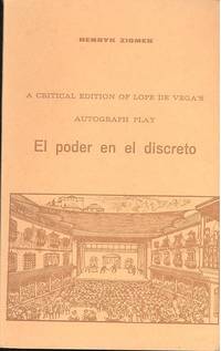
Ziomek Henryk. ; Vega Lope de 1562 1635.
A critical edition of Lope de Vega's autograph play El Poder en el Discreto.
Madrid : Graficas Molina 1969 1969. Fine. 190 p. facsims. Text in Spanish; introd. and notes in English. ; OCLC: 759417 ; pictorial paper covers; FINE [Madrid] : [Graficas Molina], [1969] unknown
書籍販売業者の参照番号
: 279E
|
|
|
Ziomek Henryk.
Refexiones del Quijote.
Madrid : Gráficas Molina 1969 1969. Fine. 93 p. ; 20 cm. OCLC: 893979 ; LC: PQ6352; Dewey: 863.32 ; pictorial paper covers; FINE [Madrid] : [Gráficas Molina], [1969] unknown
書籍販売業者の参照番号
: 277E

|
|
|
ZOLEZZI GUIDO
HISTORIA DEL SALARIO INDIGENA DURANTE EL PERIODO COLONIAL EN CHILE.
Santiago De Chile 0 IN 8 broché, 165 pages, 4 illustrations. Dos jauni
書籍販売業者の参照番号
: 2067
|
|
|
Zoom - Le magazine de l'image
Zoom N° 30Norman Rockwell au tranchant du grand rêve américain - Portugal. Les photos de reportage - Christian Vogt. Les nuages coulent de source
N° 30 - mai-juin 1975 - Couverture : Photo de Erwin Blumenfeld (Grace Kelly), réalisée en studio avec le mannequin Puce - revue illustrée - Broché
書籍販売業者の参照番号
: 35457
|
|
|
ZORRO, Joán (João, Johán, Xoán o Xohán Zorro).
Las once Cantigas de Juan Zorro. Edición, introducción, traducción y notas de Manuel Alvar. Dibujos de Julio Alvar.
Granada, Universidad, 1969. 4to. menor; 146 pp., 1 h. Ilustraciones a toda plana en tinta azul. Texto en gallego-portugués y castellano en páginas enfrentadas. Cubiertas originales.
|
|
|
ZUBER CHRISTIAN
VENEZ VOIR L'ESPAGNE
***. non daté. In-8. Broché. Bon état, Couv. convenable, Dos satisfaisant, Intérieur frais. 72 pages illustreées de photos ne couleurs dans le texte et hors texte. Couverture rempliée.. . . . Classification Dewey : 946-Espagne, Portugal
書籍販売業者の参照番号
: RO30070358

|
|
|
ZUBER CHRISTIAN
VENEZ VOIR L ESPAGNE
CAMERA AU POING. Non daté. In-4. Broché. Bon état, Couv. convenable, Dos satisfaisant, Intérieur frais. 72 pages augmentees de nombreuses illustrations en couleurs dans et hors texte - non date. . . . Classification Dewey : 946-Espagne, Portugal
書籍販売業者の参照番号
: RO30146772
|
|
|
Zukunftswerkstatt Mariposa
Ein Kulturprojekt
(Regensburg, Lindinger & Schmid, 2001). 4to. Mit zahlreichen, teils farbigen Abbildungen. 296 S., 3 Bl. Or.-Pp. mit Schutzumschlag. [5 Warenabbildungen]
書籍販売業者の参照番号
: 154719

|
|
|
Zurara Gomes Eanes de ca. or Esteves Pereira Francisco Maria Academia das Ciencias de Lisboa Portugal. Arquivo Nacional. MSS
Crónica de tomada de Ceuta por el Rei D. João I 1915 Leather Bound
2019. Leather Bound. New. Leather Binding on Spine and Corners with Golden Leaf Printing on round Spine. Reprinted in 2019 with the help of original edition published long back 1915. This book is printed in black & white sewing binding for longer life Printed on high quality Paper re-sized as per Current standards professionally processed without changing its contents. As these are old books we processed each page manually and make them readable but in some cases some pages which are blur or missing or black spots. If it is multi volume set then it is only single volume if you wish to order a specific or all the volumes you may contact us. We expect that you will understand our compulsion in these books. We found this book important for the readers who want to know more about our old treasure so we brought it back to the shelves. Hope you will like it and give your comments and suggestions. Lang: - por Pages 476. EXTRA 10 DAYS APART FROM THE NORMAL SHIPPING PERIOD WILL BE REQUIRED FOR LEATHER BOUND BOOKS. FOLIO EDITION IS ALSO AVAILABLE. hardcover
書籍販売業者の参照番号
: LB1111005879211
|
|
|
Zurara Gomes Eanes de ca. or Esteves Pereira Francisco Maria Academia das Ciencias de Lisboa Portugal. Arquivo Nacional. MSS
Crónica de tomada de Ceuta por el Rei D. João I 1915 Hardcover
2020. Hardcover. New. Lang: - por Pages 476. Reprinted in 2020 with the help of original edition published long back 1915. This book is Printed in black & white Hardcover sewing binding for longer life with Matt laminated multi-Colour Dust Cover Printed on high quality Paper re-sized as per Current standards professionally processed without changing its contents. As these are old books we processed each page manually and make them readable but in some cases some pages which are blur or missing or black spots. If it is multi volume set then it is only single volume if you wish to order a specific or all the volumes you may contact us. We expect that you will understand our compulsion in these books. We found this book important for the readers who want to know more about our old treasure so we brought it back to the shelves. Any type of Customisation is possible with extra charges. Hope you will like it and give your comments and suggestions. hardcover
書籍販売業者の参照番号
: 1111005879211
|
|
|
Zurara Gomes Eanes de ca. or Esteves Pereira Francisco Maria Academia das Ciencias de Lisboa Portugal. Arquivo Nacional. MSS
Cr�nica de tomada de Ceuta por el Rei D. Jo�o I 1915
2020. Paperback. New. Lang: - por Pages 476. Reprinted in 2020 with the help of original edition published long back 1915. This book is Printed in black & white sewing binding for longer life with Matt laminated multi-Colour Soft Cover HARDCOVER EDITION IS ALSO AVAILABLE Printed on high quality Paper re-sized as per Current standards professionally processed without changing its contents. As these are old books we processed each page manually and make them readable but in some cases some pages which are blur or missing or black spots. If it is multi volume set then it is only single volume if you wish to order a specific or all the volumes you may contact us. We expect that you will understand our compulsion in these books. We found this book important for the readers who want to know more about our old treasure so we brought it back to the shelves. Any type of Customisation is possible with extra charges. Hope you will like it and give your comments and suggestions. paperback
書籍販売業者の参照番号
: PB1111005879211
|
|
|
ZUSTER LUCIA (& Luis KONDOR, samenstelling)
Herinneringen van zuster Lucia [m.b.t.Fatima]
Fatima, Postulaçao 1978 222pp., geïllustreerd, geïllustreerde omslag, 20cm., goede staat, R25192
書籍販売業者の参照番号
: R25192
|
|
|
ZUSTER LUCIA (& Luis KONDOR, samenstelling)
Herinneringen van zuster Lucia [m.b.t.Fatima]
222pp., geïllustreerd, geïllustreerde omslag, 20cm., goede staat, R25192
|
|
|
Zwei Postkartenalben in Leporelloform
(Barcelona, 50er Jahre)
o.J. Or.-Kart.-Umschlag; tlw. gebräunt. [4 Warenabbildungen]
書籍販売業者の参照番号
: 169449

|
|
|
ZWIJGERS Tineke, FADO O.
Le Portugal. Collection : Curiosités et Délices.
Bruxelles, KBC Groupe, 2010. 17 x 25, 96 pp., très nombreuses illustrations et cartes en couleurs, reliure d'édition carton imprimé, très bon état.
書籍販売業者の参照番号
: 68946
|
|
|
« Ut Videam » 10 ans du coup d'état, Portugal (propriétaire), Ex-libris.
Ex-libris.
Ex libris (91*68mm).
書籍販売業者の参照番号
: 004275

|
|
|
ÁLVARES SOARES, António.
Rimas varias (Lisboa, 1628). Con el "Elogio Fúnebre a Spinola", Amberes, 1631, en Apéndice. Introducción de Antonio Pérez Gómez.
Valencia, "la fonte que mana y corre", 1963 (Duque y Marqués, Opúsculos Literarios Rarísimos). 4to. menor; XI pp., 153 pp., 3 hs. Edición limitada y numerada de 225 ejemplares. Cubiertas originales.

|
|
|
 検索結果のメールを受信する
 PDFファイルの検索結果をダウンロード
 RSSフィード
