|
O E I BERTOLA
Ecole de Navigation sous marine - Technologie.
Toulon , AEMF , 1956 , in4° broché et agrafé , 180 pp . Abondantes figures . Exemplaire en état d' usage avec la couverture défraichie et des annotations sur quelques pages .
Référence libraire : M17252
|
|
|
O'BRIAN Patrick
The Hundred Days
New York: W.W. Norton & Company 1998. Hardcover. 8vo. Blue cloth spine with gilt lettering and pale blue paper over boards pictorial dust jacket. 281pp. Illustration. Fine/near fine. Small abrasion at upper right of front flyleaf. First American edition of the 19th novel in the Aubrey/Maturin series -- tight and handsome. W.W. Norton & Company hardcover
Référence libraire : 39082 ISBN : 0393046745 9780393046748

|
|
|
O'BRIAN, Patrick
CAPITÁN DE MAR Y GUERRA. Aubrey y Maturin I - Barcelona 1997
Barcelona, Edit. Edhasa, 1997. Una novela de la armada inglesa. 472 p. 8º. Rústica editorial ilustrada. Muy buen ejemplar.
|
|
|
O'Brien, John S.
BY DOG SLED FOR BYRD. 1600 Miles Across Antarctic Ice.
192p. + Plus photographs. Decorated title page. Decorated endpapers. Bookplate of Robert D. Hoffsommer, Civil War author. Tall 8vo. Original full blue cloth binding, silver lettered. Very slight soiling to binding. Nice copy. First edition. POLAR 4
|
|
|
O'NEIL, Paul
The Rivermen
New York: Time-Life Books 1975. Hardcover. Small 4to. Heavily blind-embossed leatherette with tipped on color plate. 240pp. Frontispiece numerous illustrations many color maps. Near fine. First edition "tight 'n bright" of this volume in Time-Life's "Old West" series. Time-Life Books hardcover
Référence libraire : 5398
|
|
|
Oberkommando der Kriegsmarine, (Hrg.)
Verzeichnis der Leuchtfeuer und Signalstellen aller Meere 1943 - Teil V: Mittelmeer, Schwarzes Meer und Asowsches Meer.
Berlin, E. S. Mittler & Sohn, 1943. (abgeschlossen am 31. Dezember 1942) - Einundsiebzigste Auflage. . ill OKt., 589 / 104 S., Gr.8°
Référence libraire : 10655
|
|
|
Obregón, Mauricio
Odyssee auf Flügeln. Eine Flugreise in die Welt Homers. Mit einer Einführung von Samuel Eliot Morison. 30 Photos von Christina Marinez-Irujo de Obregón. Übersetzung aus dem Englischen von Helmuth Eggert.
Wiesbaden : Brockhaus, 1975. 188 S. mit 30 Fotos und 8 Karten; 23 cm, gebunden, Orig.-Leinen mit Orig.-Schutzumschlag,
Référence libraire : 68022

|
|
|
Oettinger, Johannes (1577-1633). - Oehme, Ruthardt
Johannes Oettinger 1577 - 1633 : Geograph, Kartograph und Geodät.
Stuttgart, W. Kohlhammer Verlag, 1982. gr8° (23x17), XIII, 120 S., farb Frontispiz, 3 Titelblatt-Faksmilies im Text, 1 mehrfach gefaltete farb Kartenbeilage in Deckeltasche (Liebenzeller Forst), OKart (Brosch), ohne Gebrauchsspuren, offensichtlich ungelesen, [= Veröffentlichungen der Kommission für Geschichtliche Landeskunde in Baden-Württemberg: Reihe B (Forschungen); 103],
Référence libraire : 31646AB ISBN : 317007699

|
|
|
OEXMELIN Alexandre-Olivier ( EXMELIN ou EXQUEMELIN )
LES AVENTURIERS ET LES BOUCANIERS D'AMÉRIQUE
Paris Aux Editions du Carrefour 1930 in 8 (24x19) 1 volume reliure demi basane rouge de l'époque, dos lisse, couverture conservée, 370 pages, avec des illustrations en noir et blanc, dont hors-texte (certaines à double page), et grande carte dépliante in fine. Edition enrichie de documents, gravures anciennes et de cartes géographiques, publiée par Bertrand Guégan. Collection "Voyages et Découvertes". Alexandre-Olivier Exquemelin ou Oexmelin, 1645-1707, médecin et flibustier français, chirurgien des Aventuriers de 1666 à 1672. Bel exempllaire ( Photographies sur demande / We can send pictures of this book on simple request )
Référence libraire : 18671
|
|
|
OFAIRE, Cilette.
A través de Europa por canales y ríos. Traducción de Luys Santa Marina.
Barcelona, I.G. Seix y Barral Hnos., 1942. 4to. menor; 189 pp., 1 h. Cubiertas originales.
|
|
|
Office National de la Navigation
GUIDE DE LA NAVIGATION INTERIEURE. Tome 1 & 2
2 volumes cartonnés . format moyen. Tome 1. 617 pages . Tome 2 Atlas. 311 pages. L'ensemble en bon état. Une expédition par mondial Relay pourra vous être proposée 1965 Berger levrault
Référence libraire : 18627

|
|
|
Office De La Navigation
Rapport sur le fonctionnement de l'office de la navigation pendant l'exercice 1952
Ministère des travaux publics et de la reconstruct 1952 in4. 1952. Broché.
Référence libraire : 100123922

|
|
|
Office De La Navigation
Rapport sur le fonctionnement de l'office de la navigation pendant l'exercice 1952
Ministère des travaux publics et de la reconstruct 1952. in4. 1952. Broché. Ministère des travaux publics et de la reconstruct unknown
Référence libraire : 100123922
|
|
|
OFFREY CHARLES
HENRI CANGARDEL. ARMATEUR. 1881-1971.
P., Les Editions de l'Atlantique, 1973. In-8 broché, 364 pages dont 12 pages d'illustrations photographiques. Bon état. Envoi de l'auteur.
|
|
|
OFFREY, Charles.
Cette grande dame que fut la Transat.
in-8, 207 pages, illustrationsN/B, broche, couverture illustrée. Tres bel exemplaire. [PH-3]
|
|
|
Ohlrogge, Egon
Angewandte Radarkunde. Praxis für die Berufs- und Sportschifffahrt.
Hamburg, DSV-Verlag, 2001. 25 cm, 168 Seiten, mit zahlreichen Illustrationen und graphischen Darstellungen, nachtblauer farbig illustrierter Hochglanzpappband. 1. Auflage Einband leicht berieben, gut erhalten.
Référence libraire : 37110AB ISBN : 388412353
|
|
|
ohne Angabe
Académie de Marine. Tome I. 1922 - Tome III. 1924 KOMPLETT. Communications et Mémoires. Ome I, Tome II, Tome III ( Fascicule 3 - 6 )
Paris, Société d'Editions Géographiques, Maritimes et Coloniales, 1923. 236, VII, 120, 44, 24, 29, 24S., mit Illustrationen und Karten, 4° OHalbleinen, mit handgeschriebenen Rückentitel
Référence libraire : 165732

|
|
|
OLAGUE, I. (pres. et comm. par).
Journal de bord de Jean de la COSA, second de Christophe Colomb.
in-8, 255 pp., ill. in et h.t. n., broche, couv. ill. à rabats. Bel exemplaire. [HI-4/2]
|
|
|
OLIVEAU Maurice
Abc de la navigation
Arthaud 1987 122 pages in-8. 1987. broché. 122 pages. Nombreuses figures en noir
Référence libraire : 16803

|
|
|
OLIVEAU Maurice
ABC de la navigation.
Arthaud Arthaud, 1987, 122 p., broché, bords de la couverture un peu frottés, bon état pour le reste et intérieur bien propre.
Référence libraire : 116669
|
|
|
OLIVEIRA, Mauricio de.
La Tragedia Española en el Mar. II: Las dos Españas en el Mar. Traducción del portugués por José Andrés Vázquez.
Cádiz, Establecimientos Cerón, 1937. 4to.; 168 pp. y 22 láminas con ilustraciones fotográficas. Cubiertas originales.

|
|
|
Olson, Louis B.
Olson's Small Boat Seanmanship
417 p., illus. Hardcover Good condition; fronthinge cracked
|
|
|
Ontario Comm. Of Internal Navigation
Reports of the Commissioners of Internal Navigation Appointed by His Excellency Sir Peregrine Maitland R. C. B. &C. &C. &C. In Pursuance of an . Second Year of His Majesty's Reign Entitl
paperback. Good. Access codes and supplements are not guaranteed with used items. May be an ex-library book. paperback
Référence libraire : 1528408136.G ISBN : 1528408136 9781528408134
|
|
|
Opela, Anna und Bernd Oberhuber
100 Jahre am See. Die Millstätter Schifffahrtsgesellschaft 1901-2001.
(Millstätter Schifffahrtsgesellschaft 2001). 47 S., mit 54 Abb., Foto-OPappbd., fast keine Gebrauchsspuren.
Référence libraire : AUST0473
|
|
|
OPPERMANN C. A. ( dirigé par )
PORTEFEUILLE ÉCONOMIQUE DES MACHINES DE L'OUTILLAGE ET DU MATÉRIEL relatif à la construction, aux chemins de fer, aux routes, aux mines, à la navigation, à la télégraphie, etc. Années 1870 à 1891
Paris Dunod, Editeur 1870 in folio (37x28) 6 forts volumes reliure demi chagrin vert de l'époque, dos lisses ornés de faux-nerfs à froid et de fleurons dorés. Volumes illustrés nombreuses figures dans le le texte, et de nombreuses planches hors-texte. Contenant un choix des objets les plus intéressant des expositions industrielles, destiné aux ingénieurs, mécaniciens, conducteurs, constructeurs de machines, contre-maitres, chefs d'atelier, élèves des écoles, entrepreneurs ouvriers. Rare ensemble. Du tome 15: Années 1870 (15e année) au tome XVI de 1891 (3ème série, 36e année). Importante documentation. Ensemble 6 volumes en reliures uniformes de l'époque et en bel état ( Photographies sur demande / We can send pictures of this book on simple request )
Référence libraire : 054108
|
|
|
Oregon Railroad & Navigation Co.
The Columbia River Through the Cascade Mountains to the Pacific Ocean
Portland Oregon: The Oregon Railroad & Navigation Co. Fine with no dust jacket. 1906. First Edition. Original Wraps. Map unfolds to about 1 1/2'x5'. Colored semi-topographical map of the Columbia River with towns etc. Really cool!; Map; 4 1/2x9 1/2" . The Oregon Railroad & Navigation Co. paperback
Référence libraire : 8656
|
|
|
Oregon Railway and Navigation Company
OREGON. FACTS REGARDING ITS CLIMATE SOIL MINERAL AND AGRICULTURAL RESOURCES MEANS OF COMMUNICATION COMMERCE AND INDUSTRY LAWS ETC. ETC. FOR GENERAL INFORMATION. WITH MAP AND APPENDIX. THE STATE OF OREGON WAS DISTINGUISHED AT THE CENTENNIAL EXHIBITION BY MORE AWARDS FOR THE EXCELLENCE AND VARIETY OF ITS PRODUCTS THAN COMPARATIVELY ANY OTHER STATE
New York City: Eastern Office Oregon Railway and Navigation Co.; Franklin Press: Rand Avery & Co. Boston 1880. 59 1 blank pp large 17" x 19" folding Colton color map of Oregon Washington Territory part of Idaho. A few short splits along folds with no loss. Original printed wrapperssoiled and worn. Scattered spotting. A few small chips and wormholes at corners of outer leaves closed tear to title page no text loss. Good.<br/><br/> "To meet the constant and increasing demand for full information as to the climate and resources of both Eastern and Western Oregon the present pamphlet is issued. In this compilation use is made of matter entertained in pamphlets issued by Oregon State Board of Immigration. The reader is given a few of the disinterested opinions of travellers map and tables showing all that may be desired in order to arrive at a correct knowledge of this state as gathered from Facts and Figures."<br/>Adams Herd 1729. Eastern Office, Oregon Railway and Navigation Co.; Franklin Press: Rand, Avery, & Co., Boston unknown books
Référence libraire : 25667
|
|
|
OREGON RAILWAY AND NAVIGATION COMPANY
THE PACIFIC NORTH-WEST; A GUIDE FOR SETTLERS AND TRAVELERS: OREGON AND
OREGON RAILWAY AND NAVIGATION COMPANY. THE PACIFIC NORTH-WEST; A GUIDE FOR SETTLERS AND TRAVELERS: OREGON AND WASHINGTON TERRITORY. New York: Land Dept. Northern Pacific Railroad Co. 1882. 8vo. Printed wrappers. Frontispiece plate 81 pages. First edition. Scarce Western promotional travel guide to the Pacific North-West. Addressed prospective settlers and travelers alike this guide consists of historical geographical and agricultural information and discusses at length matters s as commerce climate education taxes prices and the regions of the Pacifi North-West. Each county is described and suggestions are provided to prospective emigrants such as "In mercantile pursuits the opening is good f men of enterprise and capital; but the chances for mere clerks are not good." Farm labor wages in these parts are recorded as being between $25 and $30 per month and lumber mills wages between $60 and $90 per month for first-class hands. It is also noted that "Chinamen work for the railroads and boards themselves at $1.00 a day and in winter take contracts for grubbing brush land." There are ten full-page illustrations which include a two-page "Bird's Eye Vi of Portland Oregon" "Saw Mill on Puget Sound W.T." "Astoria Oregon Entrance to Columbia River" "First Street Portland Oregon" and "Commercia Street Seattle W.T." with folding map of the region Unfolded 28 1/2 x 18 inches in the back. Spine and outer edges of wrappers sunned else good. unknown books
Référence libraire : 40603

|
|
|
Oregon-Washington Railroad & Navigation Company
Order Bill of Lading Union Pacific System Oregon-Washington Railroad & Navigation Company
Union Pacific Circa 1917 paperback Form 1564 with several pages. 1917. Paperback. Good. Light shelf wear and soiling on the covers small water stains on the covers. 2/3s of the forms have been "used" and carbon copies remain. Pacific Northwest Washington State Oregon Union Pacific History order bill of lading forms Union Pacific Circa 1917 paperback Form 1564 with several pages. paperback
Référence libraire : 8871
|
|
|
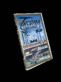
Oregon-Washington Railroad and Navigation Company
Tacoma Washington Cover Title
Tacoma: Tacoma Commercial Club and Chamber of Commerce 1911. First edition. 14x8cm 32pp. Full color and sepia photographic illustrations throughout. Single map. Detachable post card/order form present at rear. Staple bound in color lithographed card covers. Some edge rubbing and light wear else near fine. <br /> <br /> Beautiful and scarce promotional booklet a joint effort of the Oregon-Washington Railroad and Navigation Company Bureau of Community Publicity and the Tacoma Commercial Club and Chamber of Commerce. Photos of prominent buildings factories the port Mount Rainier and Stadium High School among others. Includes information on industry and culture of the fast-growing city.  <br /> <br /> <br /> OCLC cites 4 holdings only including just 1 in the state of Washington.  . Tacoma Commercial Club and Chamber of Commerce unknown
Référence libraire : 8633
|
|
|
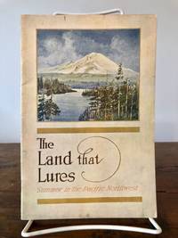
Oregon-Washington Railroad & Navigation Co
The Land that Lures: The Pacific Northwest in Summer
Portland Oregon: Oregon-Washington Railroad & Navigation Co 1913. Fourth Edition. Stiff Illustrated Wrappers. Good. 8vo. Pp. 45 3. Frontis. scenic photograph. Illustrated with black & white halftone photo reproductions and one route map. Color illustrated wraps saddle-stapled. Light soiling and stains mellowed crease to back cover staples a tad oxidized trace of oxidized paperclip to head of the frontis. In sum a bright copy. Revised edition of the enticing 1911 tourism booklet lauding sites natural and man-made from Oregon to Alaska. Includes motoring tours and hiking in Mount Rainier National Park plus lakes and streams to cast the lure. The uncredited color illustrations are dreamy; the photography including a few shots by Asahel Curtis presents keen insight into early 1900s life in the Puget Sound Country. SMITH 7721.<p>Preserved in a removable clear archival pouch with acid-free backing. Oregon-Washington Railroad & Navigation Co unknown
Référence libraire : 7087
|
|
|
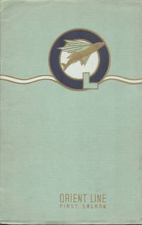
Orient Steam Navigation Company, Limited (Hrsg.).
Orient Line to England via Suez. Royal Mail Steamers. First saloon prospectus.
London Orient Line Office 1937. . Fotos der Linienschiffe - 23.400-Tonner: Orion u. Orcades und der 20.000-Tonner: Orontes Orford Otranto Oronsay u. Orama - mit ihrer Innenausstattung und Fotos der angesteuerten Orte. Mit erläuternden Texten. - Umschlag etwas verblasst Kanten mit Überstand gestaucht u. angerändert Rücken mit stumpfer Knickspur am Kapital Heftklammern mit geringer Rostspur. Der Heftblock fest u. sauber. . (London, Orient Line Office, 1937). unknown
Référence libraire : 100402
|
|
|
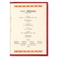
ORIENT STEAM NAVIGATION COMPANY LTD.
Orient Line to England : list of passengers and general information. R.M.S. Orama . from Brisbane . Sydney . Melbourne . Adelaide . Fremantle . September 1935.
Sydney : Orient Steam Navigation Company 1935. Octavo 186 x 127 mm original red wrappers with embossed gold lettering to front a few light marks staple bound 16 pp text printed in black and red with decorative borders in red at top and bottom margins; internally pristine a very good copy. The 20000 ton Royal Mail Steamer Orama operated passenger cargo and mail services between England and Australia from 1924 until 1940. unknown
Référence libraire : 24588
|
|
|
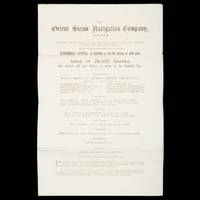
ORIENT STEAM NAVIGATION CO., LTD.
The Orient Steam Navigation Company Limited. Prospectus.
London : The Orient Steam Navigation Co. Ltd. 13 Fenchurch Avenue E.C. 1880. Folio 420 x 265 mm bifolium 3 pp folding to 265 x 105 mm with printed title to outer side; original share application form still loosely enclosed; outer side a little dusty but a near fine example. 'The Orient Steam Navigation Company was established in 1878 and jointly managed by the London shipowning firms of Anderson Anderson and Company and F. Green and Company until 1919 when the Peninsular and Oriental Steam Navigation Company acquired a controlling interest in its shareholding capital; at approximately the same time the dual management of the undertaking by the Anderson and Green companies came to an end and the two businesses were merged into a private limited company formed for the purpose Anderson Green and Company Limited. The Orient company was a small enterprise operating a handful of very large ships in virtually one trade the mail and passenger service to Australia and New Zealand. In due course it provided a co-ordinated service in this region with ships of the P&O fleet; in later years similarly in collaboration with P&O a passenger service between North American ports and Australia and New Zealand was instituted and in attempts to promote passenger traffic in the Pacific a series of voyages between North America the Far East and Australia were inaugurated. The company's ships were also extensively employed in ocean cruising.' Royal Museums Greenwich Internal references date this very early Company prospectus to 1880. Trove locates no copies. unknown
Référence libraire : 26003
|
|
|
ORIGINAL PHOTOGRAPH.
[MALTA / NAVAL FORCES] Sanli Türk donanmasinin dost Ingiliz donanmasini Malta'da ziyareti, 19.7.1937. [i.e. Turkish fleet visiting friendly British naval forces in Malta].
Very Good Turkish Original albumen print mounted on cardboard. 21x48 cm. Handwritten Turkish note at the lower on empty section. Dated July 19, 1937. Slight fading on board. The photo is in very good condition. It was very significant both politically and militarily showing a Turkish war fleet visiting the British navy in Valletta, the capital of Malta, in 1937. The commander of the fleet was Admiral Sükrü Okan (1880-1957). The Turkish fleet consisted of the cruisers and destroyers named Yavuz Selim, Adatepe, Tinaztepe, Kocatepe, and Zafer, as well as four submarines and the submarine mothership Erkin. This very scarce photograph shows the Turkish fleet with the English fleet in the Valletta port on July 19, 1937.
|
|
|
Orleans Navigation Co
ORLEANS NAVIGATION COMPANY REPORT
Washington: NP. Very Good. 1829. Paperback. Pamphlet disbound 20pp. some foxing good. 20th Congress 2d Session Rep. No. 62. Ho. of Reps. . NP paperback
Référence libraire : 57255
|
|
|
Orleans Navigation Co
ORLEANS NAVIGATION COMPANY REPORT
Washington: NP. Very Good. 1829. Paperback. Pamphlet disbound 20pp. some foxing good. 20th Congress 2d Session Rep. No. 62. Ho. of Reps. . NP paperback books
Référence libraire : 57255
|
|
|
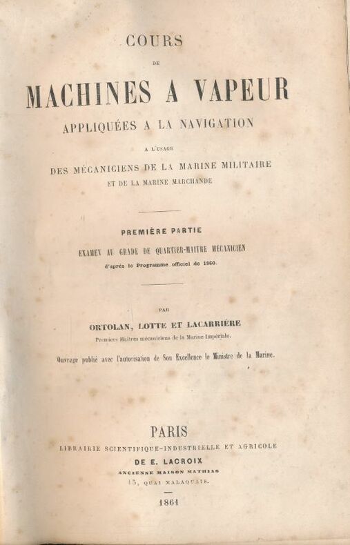
ORTOLAN - LOTTE - LACARRIERE
Cours de machines à vapeur, appliquees a la navigation a l'usage des mecaniciens de la marine militaire et de la marine marchande. Premiere partie. Examen au grade de quartier-maitre mecanicien d'apres le programme officiel de 1860
E Lacroix Paris, E Lacroix, 1861. In-8 relié demi-basane noire, dos lisse, titre doré (coiffe abimée) de XII + 344 pages. Rousseurs et page de garde restaurées.
Référence libraire : 155535
|
|
|
ORTOLAN (J.-A.)
Mémorial du Mécanicien d'usine et de navigation
Paris, Gauthier-Villars, 1878. In-8 relié percaline prune, 524 p. Contient : Calculs d'application - Tables et tableaux de résultats pour la construction, les essais et la conduite des machines à vapeur. Très bon état. Dédicace de l'auteur à Monsieur le Capitaine de Vaisseau Vignancourt.
Référence libraire : 16340
|
|
|
ORTIZ DE LA TABLA DUCASSE, Javier.
Comercio Exterior de Veracruz (1778 - 1821). Crisis de Independencia. Prólogo de José Antonio Calderón Quijano.
Sevilla, Escuela de Estudios Hispanoamericanos, 1978. 4to. mayor; XXVIII pp., 456 pp., con numerosos gráficos y 13 láminas. Cubiertas originales.

|
|
|
ORTOLAN - LOTTE - LACARRIERE
Cours de machines à vapeur, appliquees a la navigation a l'usage des mecaniciens de la marine militaire et de la marine marchande. Premiere partie. Examen au grade de quartier-maitre mecanicien d'apres le programme officiel de 1860
Paris, E Lacroix, 1861. In-8 relié demi-basane noire, dos lisse, titre doré (coiffe abimée) de XII + 344 pages. Rousseurs et page de garde restaurées.
|
|
|
Ortung und Navigation
5 Hefte
Deutsche Gesellschaft für Ortung und Navigation Düsseldorf 1974/76/78. Zusammen ca. 830 S. kart. - Enthalten: Vierteljahres-Mitteilungen II/III 1976/Zeitschrift-Journal 2/1978/Vierteljahres-Mitteilungen I/74 II/74 und III/74 - unknown
Référence libraire : 1f4939
|
|
|
OSBONNE E
LA NAVIGATION MARITIME
P , Quantin ,sd ( v 1900 ) in8 broché , 328 pp . Abondantes gravures
Référence libraire : M15387
|
|
|
OSBORNE Brian D
The Ingenious Mr Bell. A Life of Henry Bell (1767-1830), Pioneer of Steam Navigation. NEAR FINE COPY IN UNCLIPPED DUSTWRAPPER
8vo., First Edition, with illustrations in the text; brown cloth, gilt back, a near fine copy in unclipped dustwrapper.

|
|
|
OSMAN ÖNDES.
Vapur donatanlari ve acenteleri tarihi.
New New Turkish Original bdg. Dust wraper. 4to. (29 x 25 cm). In Turkish. 304 p., b/w and color ills. Vapur donatanlari ve acenteleri tarihi.
|
|
|
OSTENDORF, Rolf
Eisenbahn-Knotenpunkt Ruhrgebiet - Die Entwicklungsgeschichte der Revierbahnen seit 1838
, Stuttgart, Motorbuch Verlag, 1979, 272pp.with ill., hardcover with dustwrapper, VG
Référence libraire : A14991
|
|
|
OSTENDORF, Rolf
Eisenbahn-Knotenpunkt Ruhrgebiet - Die Entwicklungsgeschichte der Revierbahnen seit 1838
Stuttgart, Motorbuch Verlag, 1979, 272pp.with ill., hardcover with dustwrapper, VG
|
|
|
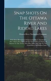
Ottawa River Navigation Company
Snap Shots On The Ottawa River And Rideau Lakes: With Many Illustrations Of Interesting Places And Scenes: Also A Short Description Of The Ottawa River & Points Of Interest To The Tourist Who May Make The Trip Via The Grand River And Rideau Lakes
new. unknown
Référence libraire : 45470920-n ISBN : 1016299273 9781016299275
|
|
|
Ottawa River Navigation Company
Snap Shots On The Ottawa River And Rideau Lakes: With Many Illustrations Of Interesting Places And Scenes: Also A Short Description Of The Ottawa River & Points Of Interest To The Tourist Who May Make The Trip Via The Grand River And Rideau Lakes
like new. unknown
Référence libraire : 45470920 ISBN : 1016299273 9781016299275
|
|
|
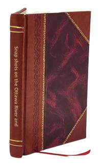
Ottawa River Navigation Co
Snap shots on the Ottawa River and Rideau Lakes 1898 Leather Bound
2016. Leather Bound. New. Size: 14.60 x 22.86 cms This book is available in 5 different Leather color without any extra cost. Explore More Options by Clicking on 'More Images' and Notify Us of Your Choice via Email within 24 hours of placing the order. Presenting an Exquisite Leather-Bound Edition expertly crafted by the prestigious organization “Rare Biblio” with Original Natural Leather that gracefully adorns the spine and corners. The allure continues with Golden Leaf Printing that adds a touch of elegance while Hand Embossing on the rounded spine lends an artistic flair. This masterpiece has been meticulously reprinted in 2016 utilizing the invaluable guidance of the original edition published many years ago in 1898. The contents of this book are presented in classic black and white. Its durability is ensured through a meticulous sewing binding technique enhancing its longevity. Imprinted on top-tier quality paper. A team of professionals has expertly processed each page delicately preserving its content without alteration. Due to the vintage nature of these books every page has been manually restored for legibility. However in certain instances occasional blurriness missing segments or faint black spots might persist. We sincerely hope for your understanding of the challenges we faced with these books. Recognizing their significance for readers seeking insight into our historical treasure we've diligently restored and reissued them. Our intention is to offer this valuable resource once again. We eagerly await your feedback hoping that you'll find it appealing and will generously share your thoughts and recommendations. Lang: - English Vol:- Pages:- 63 If it is a multi-volume set then it is only a single volume. Product Disclaimer: Kindly be informed that owing to the inherent nature of leather as a natural material minor discolorations or textural variations may be perceptible. Explore the FOLIO EDITION 12x19 Inches: Available Upon Request. hardcover
Référence libraire : BIBLB000891731
|
|
 Recevoir par e-mail
 Télécharger en PDF
 Flux RSS


