|
|
|
[Ouest-France]
HISTOIRE : L'OUEST à TRAVERS les ARCHIVES de la PRESSE - N° 4 - 2021
Une publication de 96 pages, format 210 x 250 mm, illustrée, brochée, publiée en 2021, Ouest-France, bon état
Bookseller reference : LFA-126727367
|
|
|
[Science et Vie]
SCIENCE et VIE - n° 311 - Juillet 1943
Une revue de 56 pages, format 165 x 245 mm, illustrée, brochée couverture couleurs, bon état
Bookseller reference : LFA-126735004
|
|
|
[Science et Vie]
SCIENCE et VIE - n° 321 - mai 1944
Une revue de 56 pages, format 165 x 245 mm, illustrée, brochée couverture couleurs, bon état
Bookseller reference : LFA-126735016
|
|
|
[Timbres Magazine]
TIMBRES MAGAZINE - L'OFFICIEL DE LA PHILATELIE n° 9 (Janvier 2001)
Revue mensuelle conernant la philatélie : environ 110 pages en couleurs, format 300 x 210 mm, illustrée, brochée couverture couleurs + fiches détachables
Bookseller reference : LFA017e6
|
|
|
A cura di M. Cortelazzo.
Mediterraneo e Oceano Indiano. Atti del VI Colloquio di storia marittima (Venezia, 20-29 settembre 1962).
cm. 15 x 23, viii-418 pp. Rilegato. Fondazione Giorgio Cini - Civilt? veneziana - Studi 724 gr. viii-418 p.
|
|
|
A Son of the Ocean
A Home on the Deep; Or the Mariner's Trials on the Dark Blue Sea
Boston: Higgins Bradley and Dayton 1858. First edition. Wear to cloth at the head and foot of the spine some light shelf wear as well the text is bright clean and unused; overall a very good copy. Pp. 483; 17 text-figures wood-engraving. Publisher's original red cloth blind-stamped with a three-mast ship on the front and rear cover spine is lettered in gilt 8vo. The preface states "The object of the present volume has been to afford a series of brief and interesting sketches which might be both useful and attractive to the seaman and afford a convenient pastime for his leisure moments." Contains 90 small chapters detailing ship-wrecks mutiny famous captains and all other sea-faring tales from all parts of the maritime world. Signature of H. Hastings dated March 24 1859 on the front endpaper. Boston: Higgins, Bradley and Dayton, 1858. First edition. hardcover
Bookseller reference : 7825
|
|
|
A Son Of The Ocean
A Home On The Deep: Or The Mariner's Trials On The Dark Blue Sea 1857
Kessinger Publishing LLC 2007-10-22. Paperback. Used:Good. Kessinger Publishing, LLC paperback
Bookseller reference : DADAX0548650349 ISBN : 0548650349 9780548650349
|
|
|
A Son Of The Ocean
A Home On The Deep: Or The Mariner's Trials On The Dark Blue Sea 1857
Kessinger Publishing LLC 2007-10-22. Paperback. Good. Kessinger Publishing, LLC paperback
Bookseller reference : SONG0548650349 ISBN : 0548650349 9780548650349
|
|
|
A. ALLIX, R. GUILLIEN, J. LAMBERT et R. PELLOUX
Les FONDEMENTS de la POLITIQUE EXTERIEURE des ETATS-UNIS
Un ouvrage de 205 pages, format 155 x 240 mm, broché, publié en 1949, Librairie Armand Colin, collection "Cahiers de la Fondation Nationale des Sciences Politiques" n° 8, bon état (avec un envoi de Robert Pelloux au Professeur André Fugier)
Bookseller reference : LFA-126717679
|
|
|
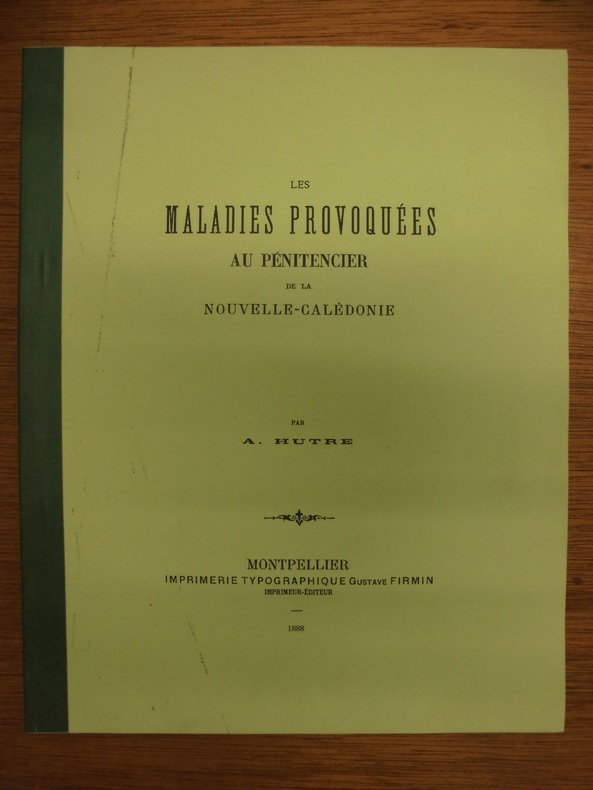
A. Hutre
Les Maladies Provoquées au Pénitencier de la Nouvelle-Calédonie
n. d., Gustave Firmin, Montpellier. Brochure petit in-4, 58pp. Fac-similé non daté de la thèse de médecine soutenue en 1888 par A. Hutre, médecin de marine. Exemplaire en excellent état
Bookseller reference : OCE203M
|
|
|
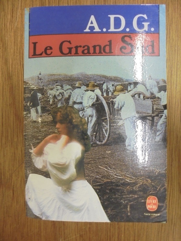
A.D.G.
LE GRAND SUD
EDITIONS LIVRE DE POCHE N° 6623. 1989. In-8. Broché. 756 pages. Très bon exemplaire
Bookseller reference : OCE150M
|
|
|
Aa Vv.
L'umanizzazione Del Mare. Riflessioni Geografiche Sugli Spazi Funzionali Costieri
Mm 165x240 Volume di 306 pp. nella sua brossura originale in buone condizioni. Atti del Convegno Nazionale tenutosi a Genova nel 1985 a cura del C.N.R. - Gruppo di Coordinamento " Geografia Umana ". Opera in ottime condizioni.
|
|
|
Aa. Vv.
Collection of maps and documents shown at the exhibition held in the Palazzo Vecchio in Florence on the quincentenary of the birth of Amerigo Vespucci. Florence 1954-55
Mm 410x305 Volume cartonato, legatura editoriale in tela, pagine non numerate con XXXIV tavole a colori e in nero. Libro in condizioni di nuovo. Testo in inglese - english text. SPEDIZIONE IN 24 ORE DALLA CONFERMA DELL'ORDINE.
|
|
|
Aa. Vv.
Il Mito Del Vapore
Mm 250x340 Introduzione di Guido Gerosa, testi di Paolo Valenti. Volume cartonato, legatura editoriale in tela marrone, astuccio in cartoncino, sovraccoperta originale, 247 pagine profusamente illustrate. Esemplare in ottime condizioni. SPEDIZIONE IN 24 ORE DALLA CONFERMA DELL'ORDINE.
|
|
|
AA. VV.
Le naufrage de la Jeannette dans l'Oc?an Glacial Arctique racont? par les membres de l'exp?dition
Ouvrage illustr? de nombreuses illustrations d'apr?s les dessins faits sur nature 1 25x16.5 cm., VIII, [4], 306 pp., frontespizio bicromo figurato, incisione all'antiporta, numerose illustrazioni e tavole nel testo, riproduzione di documenti , legatura in piena tela, piatto anteriore in percallina con ricchi fregi in oro e nero e titolo in oro, tagli dorati , in francese in ottime condizioni
|
|
|
AAF Pacific Ocean Areas.
7th AAF Brief. Vol. 2. No. 17 27 March 1945.
San Francisco 1945. 1945. 18p. Photos. Lead article on Gen Harmon. Magazine style Wraps. Very Good Copy. Paperback. Very Good. Book. San Francisco, 1945. Paperback
Bookseller reference : 80-1316
|
|
|
Abraham Barker Bark Ocean Ship :
Logbook of the Abraham Barker Ship of New Bedford mastered by Ichabod Norton on voyage from 1850-1853; Logbook of the Ocean Ship : 1850-1861 of Warren RI mastered by Ichabod Norton on voyage from 1853-1857 Volume 1850-1853; 1853-1857 1850 Hardcover
2020. Hardcover. New. Lang: - eng Vol: - Volume 1850-1853; 1853-1857 Pages 214. Reprinted in 2020 with the help of original edition published long back 1850. This book is printed in black & white Hardcover sewing binding for longer life with Matt laminated multi-Colour Dust Cover Printed on high quality Paper re-sized as per Current standards professionally processed without changing its contents. As these are old books we processed each page manually and make them readable but in some cases some pages which are blur or missing or black spots. We expect that you will understand our compulsion in these books. We found this book important for the readers who want to know more about our old treasure so we brought it back to the shelves. Any type of Customisation is possible with extra charges. Hope you will like it and give your comments and suggestions. Volume 1850-1853; 1853-1857 hardcover
Bookseller reference : 1111008998404
|
|
|
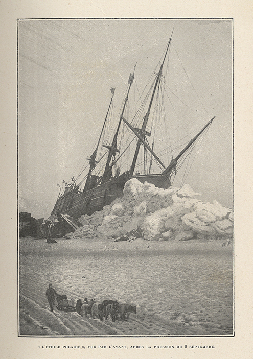
Abruzzes, S.A.R le Duc des :
Expédition de l’Etoile Polaire dans la mer arctique. 1899-1900. Traduit et résumé par M. Henry Prior.
Paris, Librairie Hachette et Cie, 1904 ; in-8, demi-chagrin vert foncé, dos à nerfs soulignés de filets à froid, fleurons décoratifs dorés, titre doré (reliure de l'époque) ; (8), 287, (1) pp., nombreuses illustrations in-texte, 34 illustrations à pleine page dont une en frontispice, 4 cartes dont une à pleine page.
Bookseller reference : 12126
|
|
|
ACLOQUE A.
SOUS LES FLOTS.
Tours, Mame, s.d. (primi '900).(mm. 258). Legatura coeva in mezza tela bianca, fregi e titolo in nero, al dorso. pp. 367 Molti disegni nel testo.
|
|
|
Ad Hoc Panel on the Use of Sailing Ships for Oceanography; Ocean Sciences Board; Assembly of Mathematical and Physical Sciences;
The Use of Sailing Ships for Oceanography
Washington: NATIONAL ACADEMY PRESS 1981-01-01. Paperback. Like New. NICE CONDITION SOFTCOVER BOOK. NO WRITING OR MARKINGS IN TEXT. NO WEAR TO COVER. A CLEAN & SOLID BOOK LIKE NEW. Washington: NATIONAL ACADEMY PRESS paperback
Bookseller reference : X-1784
|
|
|
Addison Bark Ocean Bark Cornell Peleg
Journal of the Addison Bark and Ocean Bark mastered by Peleg Cornell and kept by Peleg Cornell on whaling voyages between 1862 and 1868. 1862 Hardcover
2020. Hardcover. New. Lang: - eng Pages 164. Reprinted in 2020 with the help of original edition published long back 1862. This book is Printed in black & white Hardcover sewing binding for longer life with Matt laminated multi-Colour Dust Cover Printed on high quality Paper re-sized as per Current standards professionally processed without changing its contents. As these are old books we processed each page manually and make them readable but in some cases some pages which are blur or missing or black spots. If it is multi volume set then it is only single volume if you wish to order a specific or all the volumes you may contact us. We expect that you will understand our compulsion in these books. We found this book important for the readers who want to know more about our old treasure so we brought it back to the shelves. Any type of Customisation is possible with extra charges. Hope you will like it and give your comments and suggestions. hardcover
Bookseller reference : 1111016026144
|
|
|
ADEMOLLO Umberto -
I problemi politici del Pacifico.
Milano, 1937, stralcio con copertina posticcia muta, pp. 633/645 con 11 cartine. - !! ATTENZIONE !!: Con il termine estratto (o stralcio) intendiamo riferirci ad un fascicolo contenente un articolo di rivista, sia che esso sia stato stampato a parte utilizzando la stessa composizione sia che provenga direttamente da una rivista. Le pagine sono indicate come "da/a", ad esempio: 229/231 significa che il testo è composto da tre pagine. Quando la rivista di provenienza non viene indicata é perchè ci è sconosciuta. - !! ATTENTION !!: : NOT A BOOK : “estratto” or “stralcio” means simply a few pages, original nonetheless, printed in a magazine. Pages are indicated as in "from” “to", for example: 229/231 means the text comprises three pages (229, 230 and 231). If the magazine that contained the pages is not mentioned, it is because it is unknown to us.

|
|
|
Admiralty Charts
Anchorages in the Galapagos Islands
Anchorages in the Galapagos Islands.In the left part of the chart insert of Wreck Bay and approaches From a British survey in 1849 with additions and corrections. In the middle of the chart insert of Iguana Cove From a British survey in 1836, Webb Cove From a British survey in 1886, James Bay From a British survey in 1836, Sulivan Bay From a British survey in 1836, Terrapin Road From a British survey in 1836, Freshwater Bay From a British survey in 1836, Conway Bay From a British survey in 1846, Wreck Bay to Stephens Bay From Italian surveys in 1882 and 1885. In the right part of the chart insert of Tagus Cove From a British survey in 1835, Gardner Bay From a British survey in 1835, Post Office Bay From British surveys in 1836 and 1846, Sappho Cove From a British survey in 1883, Black Beach Anchorage From a French survey in 1887. Washington D.C., published July, 1899, at the Hydrographic Office, under the authority of the Secretary of the Navy. Small corrections: Printed: Oct. 1926. Folded editorially. Autore: Admiralty Charts. Luogo: Galapagos Islands - Pacific Ocean. Anno: '900. Tecnica: incisione. Dimensioni: 639x1105 mm

|
|
|
Admiralty Charts
Anchorages in the Solomon Islands
Anchorages in the Solomon Islands. In the upper part of the chart insert of Hat horn Sound Sketch Survey to Lieut. Marx & Torlesse, H.M.S. "Swinger" and Lieut. Elton, H.M.S. "Diamond" 1884. North of Marx P.t by Lieut. Bower, H.M.S. "Danae", 1879. With additions from a Survey by Lieut. Comm. W.U Moore, H.M.S. "Dart" 1884, Hathorn Sound Sketch Survey by Lieut C. W. Beresford and S.V. Messum under the direction of Lieut. Comm. W.U. Moore, H.M.S. "Dart" 1884, Port Diamond or Sinarango Sketch survey by the Officers of H.M.S. "Diamond", 1886. under the direction of Captain F.S. Clayton, Choiseul Bay Surveyed By Lieut. C.F. Oldham and the Officers of H.M.S. Lark, 1883. In the lower part of the chart insert of Blanche Harbour Surveyed By Lieut. C.F. Oldham and the Officers of H.M.S. Lark, 188, Plan of the Anchorage, Bambatani From a rough Sketch by Lieut. G. Stapleton, H.M.S. "Torch"1900. London Published at the Admiralty, 30th Dec. 1884, under the Superintendence of Captain W.J.L. Wharton, Hydrographer. Small corrections: 1929. Autore: Admiralty Charts. Luogo: Salomon islands - Pacific Ocean. Anno: '900. Tecnica: incisione. Dimensioni: 450x623 mm

|
|
|
Admiralty Charts
Anchorages in the Solomon Islands
Anchorages in the Solomon Islands. In the upper part of the chart insert of Pavuvu Islands (Russell Islands) Sketch Survey by Lieut. G.E. Richards and the Officers of H.M.S. Renard 1880. Pepesala (Paddy) Bay from a sketch by M.r F.J. Bayldon, "Maresby" 1908. In the lower part of the chart insert of Viru Harbour Preliminary Survey By Commander A.F. Balfour, Assisted by the Officers of H.M. Surveying ship "Penguin" 1893, Rendova Harbour Preliminary Survey By Commander A.F. Balfour, Assisted by the Officers of H.M. Surveying ship "Penguin" 1893. London Published at the Admiralty, 28th Jan. 1895, under the Superintendence of Rear Admiral W.J.L. Wharton, Hydrographer. Small corrections: 1921. Autore: Admiralty Charts. Luogo: Salomon Islands - Pacific Ocean. Anno: '900. Tecnica: incisione. Dimensioni: 649x484 mm

|
|
|
Admiralty Charts
Anchorages in the Solomon Islands
Anchorages in the Solomon Islands. In the upper part of the chart insert of Sketch of the Islands in Manning Strait between Choiseul and Ysabel Islands By M.r W. Hamilton 1908. Ysabel I from a sketch survey by Lieutenant F.C.C. Pasco, H.M. Surveying Ship "Dart" 1902. Taura Bay from an Austrian Government Plan, 1897. In the lower part of the chart insert of Sketch of the Southern portion of Lord Howe Islands (Ongtong Java or Leueneuwa) By Lieutenant G. Stapleton H.M.S. "Torch", 1900. London Published at the Admiralty, 9th May 1901, under the Superintendence of Rear Admiral Sir W.J.L. Wharton, Hydrographer. Small corrections: 1921. Autore: Admiralty Charts. Luogo: Salomon Islands - Pacific Ocean. Anno: '900. Tecnica: incisione. Dimensioni: 457x659 mm

|
|
|
Admiralty Charts
Anchorages in the Solomon Islands
Anchorages in the Solomon Islands Surveyed by Commander A.F. Balfour, assisted by the Officers of H.M. Surveying ship "Penguin" 1894. In the upper part of the chart insert of Marovo Lagoon. In the lower part of the chart insert of Mongo Entrance, Charapoana Entrance, Tongoro Entrance. London Published at the Admiralty, 24th Feb. 1896, under the Superintendence of Rear Admiral W.J.L. Wharton, Hydrographer. Small corrections: 1919. Autore: Admiralty Charts. Luogo: Salomon Islands - Pacific Ocean. Anno: '900. Tecnica: incisione. Dimensioni: 626x481 mm

|
|
|
Admiralty Charts
Anchorages in the Solomon Islands
Anchorages in the Solomon Islands. In the upper left corner of the chart insert of Beaufort Bay From a Sketch by M.r T.H. Switzer Master Schooner Roderick Dhu, 1896, Sutulahia Anch.e Sketch Survey by Lieut. W.R. Willis H.M.S. "Ringdove" 1895. In the middle part of the chart insert of Vura Anchorage From a Sketch by M.r T.H. Switzer, Master, Schooner, "Roderick Dhu"1896, Narovo Island Surveyed by Lieut. C.F. Odham and the Officers of H.M. Surveying Ship "Lark" 1882. In the right part of the chart insert of Auki Harbour Surveyed by Lieut. Com. R.L. Hancock and the Officers of H.M. Surveying Vessel "Sealark" 1913, Albatros Bay From an Austrian Government Sketch Survey, 1897, Ngora Fu Harbour From a Sketch Survey by Lieut. G.P. Bigg-Wither and the Officers of H.M.S. "Pylades", 1905. London Published at the Admiralty 20th Feb. 1907, under the Superintendence of Rear Admiral A. Mostyn Field, Hydrographer.Small corrections: 1927. Autore: Admiralty Charts. Luogo: Salomon Islands - Pacific Ocean. Anno: '900. Tecnica: incisione. Dimensioni: 617x470 mm

|
|
|
Admiralty Charts
Anchorages in the Solomon Islands
Anchorages in the Solomon Islands. In the left part of the chart insert of Kunggava Bay From a sketch by Lieut. Com. R. Crookshank, 1928, Queen Carola Harbour From a German Government Survey, 1883, Wanderer Bay By Capt. H.M. Denham, 1855. In the middle part of the chart insert of Port Adam By W. Hilliard, Master H.M.S. Havannah 1850, Mallu Harbour By M.r Haddock, 1877, Astrolabe Harbour By Mons.r Marescot, Enseigne de Vaisseau Corvette Astrolabe French Royal Navy 1838, Cockatoo Anchorage By T.C. Tilly, Master, H.M.S. Cordelia, 1861, Aowawa Roadstead By Capt. H.M. Denham, 1854. In the right part of the chart insert of Hada or Recherche Bay By T.C. Tilly, Master, H.M.S. Cordelia, 1861, Kwakwaru and Kwi Harbours Sketch by M.r W.T. Wawn 1888, Port Mary By Lieut. C.F. Oldham, 1882, Makira Bay By Capt. H.M. Denham, 1855, Hunter Roadstead By Capt. H.M. Denham, 1854, Popau H.r Sketch by M.r R. Haddock, 1877. London Published at the Admiralty March 10th 1864, under the Superintendence of Capt. G.H. Richards, Hydrographer. Small corrections. Autore: Admiralty Charts. Luogo: Salomon Islands - Pacific Ocean. Anno: '900. Tecnica: incisione. Dimensioni: 643x495 mm

|
|
|
Admiralty Charts
Anchorages in the Solomon Islands
Anchorages in the Solomon Islands. In the left part of the chart insert of Utuha H.r or Port Purvis Enlarged from a Survey by Comm. R.W. Glennie, H.M. Surveying Ship "Sealark" 1911, With Additions from a sketch Survey by Lieut. J.P. Rolleston H.M.S "Royalist", 1889, Alite H.r Langa Langa H.r Sketch Survey by Lieut. C.G.S. Eeles, H.M.S. Curacoa, 1893, Anonyma Cove Sketch Survey by Lieut. C.G.S. Eeles, H.M.S. Curacoa, 1893. In the middle part of the chart insert of Sio Harbour Sketch Survey by Lieut. J.P. Rolleston H.M.S "Royalist", 1889, Uru I. Anchorage Sketch by T.H.Switzer, Mate S.S. Rhoderick Dhu, 1894, Korombusu P.t to Susu P.t Surveyed by Commander R.W. Glennie H.M. Surveying Ship "Sealark" 1912. In the right part of the chart insert of Waisissi or Royalist Harbour Sketch Survey by Lieut. J.P. Rolleston, H.M.S. Royalist, 1889, Palaina Anchorage Sketch Survey by Lieut C.G.S. Eeles, H.M.S. Curacoa, 1893, Coleridge Bay Sketch Survey by Lieut. E. Reeves, H.M.S Royalist, 1894, Sualaha Cove Sketch Survey by Lieut. C.G.S. Eeles, H.M.S Curacoa, 1893, Mappo Harbour Sketch by T.H. Switzer, Mate of S.S. Rhoderick Dhu, 1894, S.W. Coast of Malaita By W.T. Wawn, Master of the Brigantine "Borough Belle" 1891. London Published at the Admiralty 30th May 1890, under the Superintendence of Captain W.J.L. Wharton, Hydrographer. Small corrections. Folded editorially. Autore: Admiralty Charts. Luogo: Salomon Islands - Pacific Ocean. Anno: '900. Tecnica: incisione. Dimensioni: 649x998 mm

|
|
|
Admiralty Charts
Anchorages in the Solomon Islands
Anchorages in the Solomon Islands. In the upper part of the chart insert of Jack Harbour Surveyed by Commander A.F. Balfour & Lieut. G.W. Gubbins H.M. Surveying Ship "Penguin" 1894, Baranago Harbour Surveyed by Commander R.W. Glennie and the Officers of H.M. Surveying Ship "Sealark" 1911, Rice Anchorage Sketch Survey by Lieut. S.C. Weigall, H.M. Surveying Ship "Penguin", 1895. In the middle part of the chart insert of Mboli Harbour Sketch by J.E. Scudamore Master, H.M.S. "Curacoa" 1865 Additions from a sketch by Lieut. A.C. Scott H.M.S. "Mohawk" 1898, Kolieuro Inlet Surveyed by Lieuts. C.E. Monro & S.C. Weigall under the direction of Comm. A.F. Balfour H.M. Surveying Ship "Penguin", 1895. In the lower part of the chart insert of Rua Sura I.s Anchorage Surveyed by Comm. R.W. Glennie, and the Officers of H.M. Surveying Ship "Sealark" 1912, Mosquito Anchorage Surveyed by Lieut. T.H. Heming under the direction of Lieut. C.F. Oldham, H.M. Surveying Ship "Lark" 1882, Maoraha I. & Anchorage Surveyed by Lieut. T.H. Heming under the direction of Lieut. C.F. Oldham, , H.M. Surveying Ship "Lark" 1882. London Published at the Admiralty 28th Jan. 1896, under the Superintendence of Rear Admiral W.J.L. Wharton, Hydrographer. Small corrections: 1928. Autore: Admiralty Charts. Luogo: Salomon Islands - Pacific Ocean. Anno: '900. Tecnica: incisione. Dimensioni: 630x483 mm

|
|
|
Admiralty Charts
Anchorages in Ysabel Island
Anchorages in Ysabel Island. In the left side of the chart insert of Kesuo Cove Surveyed by Lieutenant F.C.C. Pasco, assisted by Lieuts. C.E. Stainer, R. Aylen and K. Mackenzie-Grieve, H.M. Surveying Ship "Dart" 1902. In the right side of the chart insert of Tunnibuli Surveyed by Lieutenant F.C.C. Pasco, assisted by Lieuts. C.E. Stainer, R. Aylen and K. Mackenzie-Grieve, H.M. Surveying Ship "Dart" 1902. London Published at the Admiralty, 21st Dec. 1903, under the Superintendence of Rear Admiral Sir W.J.L. Wharton, Hydrographer. Small corrections: 1919. Autore: Admiralty Charts. Luogo: Ysabel Island - Salomon islands - Pacific Ocean. Anno: '900. Tecnica: incisione. Dimensioni: 461x662.

|
|
|
Admiralty Charts
Anchorages in Ysabel Island
Anchorages in Ysabel Island. In the left side of the chart insert of Korrigole Harbour Surveyed by Lieutenant F.C.C. Pasco, assisted by Lieuts. C.E. Stainer, R. Aylen and K. Mackenzie-Grieve, H.M. Surveying Ship "Dart" 1902. In the right side of the chart insert of Vulavu Anchorage Surveyed by Lieutenant F.C.C. Pasco, assisted by Lieuts. C.E. Stainer, R. Aylen and K. Mackenzie-Grieve, H.M. Surveying Ship "Dart" 1902. London Published at the Admiralty, 11th Dec. 1903, under the Superintendence of Rear Admiral Sir W.J.L. Wharton, Hydrographer. Small corrections: 1920. Autore: Admiralty Charts. Luogo: Ysabel Island - Salomon islands - Pacific Ocean. Anno: '900. Tecnica: incisione. Dimensioni: 457x652 mm

|
|
|
Admiralty Charts
Anchorages in Ysabel Island
Anchorages in Ysabel Island. In the upper part of the chart insert of Maringe Lagoon Surveyed by Lieutenant F.C.C. Pasco, assisted by Lieuts. C.E. Stainer, R. Aylen and K. Mackenzie-Grieve, H.M. Surveying Ship "Dart" 1902. London Published at the Admiralty, 21st Nov. 1903, under the Superintendence of Rear Admiral Sir W.J.L. Wharton, Hydrographer. Small corrections: 1920. Autore: Admiralty Charts. Luogo: Ysabel Island - Salomon islands - Pacific Ocean. Anno: '900. Tecnica: incisione. Dimensioni: 628x483 mm

|
|
|
Admiralty Charts
Anchorages on the North Coast of Tubuai Island - Tubuai Island
Anchorages on the North Coast of Tubuai Island From the latest F rench Government Chart. Tubuai Island From the latest French Government Charts. London Published at the Admiralty, 25th Feb. 1898, under the Superintendence of Rear Admiral Sir. W.J.L. Wharton, Hydrographer.Small corrections: 1923. Autore: Admiralty Charts. Luogo: Tubuai Islands - Pacific Ocean. Anno: 1898 [1923]. Tecnica: incisione. Dimensioni: 627x460 mm

|
|
|
Admiralty Charts
Austria Sound
Austria Sound Sketch Survey by Lieutenant Frederick C.C. Pasco, and the Officers of H.M. Surveying Ship "Dart" 1902. In the lower part of the chart insert of Allardyce Harbour Sketch Survey by Lieut. F.C.C. Pasco, & the Officers of H.M. Surveying Ship "Dart" 1902. London Published at the Admiralty, 8th Oct. 1904, under the Superintendence of Captain A. Mostyn Field, Hydrographer. Small corrections: 1919. Autore: Admiralty Charts. Luogo: Austria Sound Salomon islands. Anno: '900. Tecnica: incisione. Dimensioni: 484x656 mm

|
|
|
Admiralty Charts
Bauro or San Cristoval Island
Bauro or San Cristoval Island Surveyed by Lieutenant C.F. Oldham, assisted by Lieutenants Alex Leeper, C.F. de M. Malan, and T.H. Heming, H.M. Surveying ship "Lark" 1883-4. The Southern and Western coasts from sketch surveys made in 1793, 1855, & 1867. In the upper right corner of the chart insert of Wango Bay Sketch survey by Lieut. C.A. Buckland, H.M.S. "Royalist" 1892, Marunga Harbour Sketch survey by M.r T.H. Switzer, Master S.S. "Roderick Dhu" 1900, Star Harbour Sketch survey by M.r T.H. Switzer, Master S.S. "Roderick Dhu" 1900, London Published at the Admiralty, 19th April 1892, under the Superintendence of Captain W.J.L. Wharton, Hydrographer. Small corrections: 1921. Folded editorially. Autore: Admiralty Charts. Luogo: Bauro or San Cristoval Island - Salomon Islands - Pacific Ocean. Anno: '900. Tecnica: incisione. Dimensioni: 649x985 mm

|
|
|
Admiralty Charts
Bouganville Strait
Bouganville Strait Surveyed by Lieutenant C.F. Oldham, assisted by Lieutenants A. Leeper and T.H. Heming and Sub Lieutenant A.G. Causton, H.M. Surveying Ship "Lark" 1883-4. Bouganville I. and the adjacent waters amended from the German Government Charts of 1910-13. In the upper right corner of the chart insert of Shortland Harbour Surveyed by Lieut. C.F. Oldham and the Officers of H.M.S. "Lark", 1883-4. London Published at the Admiralty, 9th June, 1886, under the Superintendence of Captain W.J.L. Wharton, Hydrographer. Small corrections: 1930. Folded editorially. Autore: Admiralty Charts. Luogo: Bouganville Strait - Salomon islands - Pacific Ocean. Anno: '900. Tecnica: incisione. Dimensioni: 828x653 mm

|
|
|
Admiralty Charts
British New Guinea - Louisiade Archipelago
British New Guinea - Louisiade Archipelago. In the upper part of the chart insert of Rossel Island and Lagoon Sketch Survey by Lieut. A.M. Field, Assisted by Lieut.s W.P. Dawson, H.J. Gedge & V.B. Webb. H.M. Surveying Ship Dart, 1888. In the lower part of the chart insert of Pwennegwa H.r by M.M.A. Jones, S.S. Merrie, England, 1894. Rabuso Creek (Proclamation Creek). Swinger Opening. London Published at the Admiralty, 7th Oct. 1890 under the Superintendence of Captain W.J.L. Wharton, Hydrographer. Small corrections: 1924. Autore: Admiralty Charts. Luogo: British New Guinea - Pacific Ocean. Anno: '900. Tecnica: incisione. Dimensioni: 481x652 mm

|
|
|
Admiralty Charts
Gavutu and Tulagi Harbours
Gavutu and Tulagi Harbours Surveyed by Lieut. F. C.C. Pasco, assisted by Lieuts. C.E. Stainer, R. Aylen and K. Mackenzie-Grieve, H.M. Surveying ship "Dart" 1902. Gavuta Harbour surveyed by Lieuts. B.T. Somerville and S.C. Weigall under the direction of Commander A.F. Balfour H.M. Surveying ship "Penguin" 1895. London Published at the Admiralty, 5th Feb. 1904, under the Superintendence of Rear Admiral Sir W.J.L. Wharton, Hydrographer. Small corrections: 1929. Folded. Autore: Admiralty Charts. Luogo: Gavutu and Tulagi - Salomon Islands - Pacific Ocean. Anno: '900. Tecnica: incisione. Dimensioni: 645x837 mm

|
|
|
Admiralty Charts
Guadalcanal and Florida I.s with a portion of Malaita I.
Guadalcanal and Florida I.s with a portion of Malaita I. The South coast of Florida I. and North coast of Guadalcanal including Savo I are from Surveys by Commander R.W. Glennie and the Officers of H.M. Surveying Ship "Sealark", 1910-12, the remainder of the work is from various rough and imperfect sketch surveys of earlier date. West coast of Malaita I and Alite Reef, adjusted to positions determined by Lieut. Com. R.L. Hancock & the Officers of H.M.S. "Sealark", 1914. London Published at the Admiralty, 6th Nov. 1893, under the Superintendence of Captain W.J.L. Wharton, Hydrographer. Large corrections 10 th Jan. 1930. Interesting map of Guadacanal in which the capital Honiara is missing because it will be constructed only afet the second world war. Folded editorially. Autore: Admiralty Charts. Luogo: Guadalcanal - Solomon Islands - Pacific Ocean. Anno: '900. Tecnica: incisione. Dimensioni: 658x983 mm

|
|
|
Admiralty Charts
Haapai Group Northern portion - Haapai Group Southern portion
Two maps, Haapai Group Northem & Southern portion Surveyed by Captain A. Mostyn Field, Assisted by Lieutenants F.C. Pasco, A. Waugh, G.E. Nares, A.W. Lowis, C.R. Brewis, and M.r F. Payne, Boats. H.M. Surveying Ship Penguin, 1898. London Published at the Admiralty, 9th Mar. 1900, under the Superintendence of Rear Admiral Sir W.J.L. Wharton, Hydrographer. Small corrections: 1929. Folded editorially. Autore: Admiralty Charts. Luogo: Pacific Ocean - Haspai Group. Anno: '900. Tecnica: incisione. Dimensioni: 655x991 + 653x990 mm

|
|
|
Admiralty Charts
Islands and Anchorages in Cook Islands
Islands and Anchorages in Cook Islands In the upper left side of the chart insert of Arutunga Anchorage From a British Survey in 1892 and Rarotonga Island From a New Zealand Government plan of 1913 (with additions from a British survey in 1922). In the middle of the chart insert of Aitutaki Island From a British survey in 1892 (with additions from a New Zealand Gov.plan of 1906) and Atu Island From a New Zealand Gov. survey in 1919. In the right part of the chart insert of Hervey Islands From a New Zealand Gov. plan of 1906 and Mauke Island From a New Zealand Gov. plan of 1906. In the lower part of the chart insert of Avarua and Avatiu Harbors From a British survey in 1922. Washington D.C., published Apr. 1902, at the Hydrographic Office, under the authority of the Secretary of the Navy. Small corrections: Printed Mar. 1928. Folded editorialyy. Autore: Admiralty Charts. Luogo: Cook Islands - Pacific Ocean. Anno: '900. Tecnica: incisione. Dimensioni: 960x661 mm

|
|
|
Admiralty Charts
Malekula (Mallicolo) Island Northern part with portion of Malo Island
Ancient and original map of Malekula (Mallicolo) Island Northern part with portion of Malo Island Surveyed by Lieut. & Comm. G.C. Frederick, assisted by Lieut.ts H.J. Gedge, E.A. Day & H.B.T. Somerville, and Lieut. & Comm. H.E. Purey-Cust, assisted by Lieut.ts W. Pudsey-Dawson, F.C.C. Pasco & A.E.H. Marescaux, H.M. Surveying Ship "Dart" 1891-92. The West Coast: South of Malua Bay from a Sketch Survey by Lieut. K. Dixon, assisted by M.r G.J. Pacey, Gunner, H.M.S. "Archer" 1903. London Published at the Admiralty, 11th Dec. 1893, under the Superintendence of Captain W.J.L. Wharton, Hydrographer. Small corrections: 1928. Folded editorially. Autore: Admiralty Charts. Luogo: Pacific Ocean South - Malekula Island. Anno: '900. Tecnica: incisione. Dimensioni: 986x640 mm

|
|
|
Admiralty Charts
Malekula (Mallicolo) Island Southern part
Ancient and original map of Malekula (Mallicolo) Island Southern part - The East Coast surveyed by Lieut. & Comm. G.C. Frederick, assisted by Lieut.ts H.J. Gedge, E.A. Day & H.B.T. Somerville, H.M. Surveying Ship "Dart" 1891. The South and Ambrym I surveyed by Lieut. & Comm. H.E. Purey-Cust, assisted by Lieut. s W. Pudsey-Dawson, F.C.C. Pasco & A.E.H. Marescaux H.M.Surveying Ship "Dart" 1893. The West Coast North of South West Bay from a Sketch Survey by Lieut. K. Dixon, assisted by M.r G.J. Pacey, Gunner, H.M.S. "Arker", 1903. Additions to Ambrym I. from a Survey by Lieut. Comm. R.L. Hancock and the Officers of H.M. Surveying Ship "Sealark" 1914. In the left side insert of Pangkumu Bay From a French Government Plan 1906. London Published at the Admiralty, 26th June 1893, under the Superintendence of Captain W.J.L. Wharton, Hydrographer. Small corrections: 1931. Folded editorially. Autore: Admiralty Charts. Luogo: Pacific Ocean South - Malekula Island. Anno: '900. Tecnica: incisione. Dimensioni: 650x985 mm

|
|
|
Admiralty Charts
Marau Sound
Marau Sound Surveyed by Lieut. J.S.C. Bower, assisted by Sub-Lieut. A.T. Stuart, H.M.S. "Danae" 1879. In the lower left corner of the chart insert of Danae Bay By Sub-Lieutenant A.T. Stuart 1879. London Re_published at the Admiralty, 25th April 1893, under the Superintendence of Captain W.J.L. Wharton, Hydrographer. Small corrections: 1923. Autore: Admiralty Charts. Luogo: Marau Sound - Salomon Islands - Pacific Ocean. Anno: '900. Tecnica: incisione. Dimensioni: 479x649 mm

|
|
|
Admiralty Charts
Minerva Reefs
Minerva Reefs Surveyed by Captain H.M. Denham H.M.S. "Herald" 1854. Additions by Com. C.F. Oldham, H.M.S. "Egeria" 1889. In the right lower corner of the chart insert of Herald Bight. London Published at the Admiralty, 9th Sept. 1872, under the Superintendence of Rear Admiral G.H. Richards, Hydrographer. Small corrections: IX-17. Autore: Admiralty Charts. Luogo: Minerva Reefs - Pacific Ocean. Anno: '900. Tecnica: incisione. Dimensioni: 649x483 mm

|
|
|
Admiralty Charts
Moala
Moala Surveyed by E. Wilds, Master, F. Howard, Acting 2nd Master, & R.H. Napier, Acting Mate, under the direction of Captain H.M. Denham, 1856. London Published at the Admiralty, Aug. 20th 1867 under the Superintendence of Captain G.H. Richards, Hydrographer. Small corrections: 1924. Folded editorially. Autore: Admiralty Charts. Luogo: South Pacific ocean - Islan Moala - Fiji Archipelago. Anno: '900. Tecnica: incisione. Dimensioni: 815x650 mm

|
|
|
Admiralty Charts
N'Galoa Harbour Kandavu Island
N'Galoa Harbour Surveyed by Captain G.S. Nares, Assisted by Nav. Lieut. T.H. Tizard, Lieut. G.R. Bethell & Nav. Sub. Lieut. A. Havergal, H.M.S. "Challenger" 1874. London Published at the Admiralty, 18th Oct. 1875 under the Superintendence of Captain F.J. Evans, Hydrographer. Small corrections: 1920. Autore: Admiralty Charts. Luogo: Kandavu Island - Fiji Islands - Pacific Ocean. Anno: '900. Tecnica: incisione. Dimensioni: 484x652 mm

|
|
|
Admiralty Charts
Pacific Ocean Western part latitude 28"N. to 20"S. and longitude 94"E. to 160"E. including Eastern Archipelago
Pacific Ocean Western part latitude 28"N. to 20"S. and longitude 94"E. to 160"E. including Eastern Archipelago - Magnetic variation curves are for 1930. Washington D.C., published Oct. 1931, at the Hydrographic Office, under the authority of the Secretary of the Navy. Small corrections. Folded editorially. Autore: Admiralty Charts. Luogo: Pacific Ocean Western. Anno: '900. Tecnica: incisione. Dimensioni: 777x1031 mm

|
|
|
 Receive by email
 Download as PDF document
 RSS feed


