|
Southern Pacific Lines San Francisco Calif.
Station Plan of Broadway San Mateo County CA
San Francisco Calif.: Southern Pacific Company 1923 rev. 1931. Blueprint 24" x 56". From Summer Avenue to Oak Grove Avenue along California Drive. Includes Ansel Eason plot Bayshore Highway Broadway station point Kaiser Paving Wisnom Lumber Burlingame Terrace Shell Oil. Scale 1" = 100'. San Francisco, Calif.: Southern Pacific Company, 1923, rev. 1931 unknown
Referentie van de boekhandelaar : 56-0409

|
|
|
Southern Pacific Lines San Francisco Calif.
Station Plan of Klamath Falls Oregon. Map
Southern Pacific Company 1959. Revised 1960. Map. Blueline print 24" x 56". Includes Western Union Line Signal Line Texum Station Meander Line of 1872 Lake Ewauna. Scale 1" = 100'. Southern Pacific Company, 1959. Revised 1960 unknown
Referentie van de boekhandelaar : 56-0264

|
|
|
Southern Pacific Lines San Francisco Calif.
Station Plan of Redwood City San Mateo County CA
San Francisco Calif.: Southern Pacific Company 1925 rev. 1958. Blueline print 24 inches x 56 inches. From St. Francis Way to Broadway and Winslow Street. Includes Mezesville Wellesley Park Dingee Park Pacific Gas and Electric Standard Oil Co. Proposed lease limits to Redwood City for fence and cultivation purposes. Scale 1" = 100'. San Francisco, Calif.: Southern Pacific Company, 1925, rev. 1958 unknown
Referentie van de boekhandelaar : 58-0477

|
|
|
Southern Pacific Lines San Francisco Calif.
Station Plan of Cartago Inye County CA
San Francisco Calif.: Southern Pacific Company 1931 rev. 1960. Blueline print 24" x 71". No buildings. Plan details measurements along railway line. From 3100' southwest to 3900' northeast of Cartago station point. Scale 1" = 100'. San Francisco, Calif.: Southern Pacific Company, 1931, rev. 1960 unknown
Referentie van de boekhandelaar : 56-0413

|
|
|
Southern Pacific Lines San Francisco Calif.
Station Plan of Hayward Alameda County California. Map
San Francisco Calif.: Southern Pacific Company 1950. Map. Blueline print 24" x 56" notes indicate "Sheet 1 of 3." Includes Southern Pacific and Western Union Lines Hathaway Ave Meekland Ave Atlas Imperial Diesel Engine Co. Map primarily consists of signs and measurements along railroad track. Scale 1" = 100'. San Francisco, Calif.: Southern Pacific Company, 1950 unknown
Referentie van de boekhandelaar : 56-0276

|
|
|
Southern Pacific Lines San Francisco Calif.
Station Plan of Di Giorgio Kern County. Map
San Francisco Calif.: Southern Pacific San Joaquin Division 1936. Map. Scale: 1 inch = 100 feet. Blueprint. April 30 1930 revised to June 16 1936. San Francisco, Calif.: Southern Pacific, San Joaquin Division, 1936 unknown
Referentie van de boekhandelaar : 01-0055
|
|
|
Southern Pacific Lines San Francisco Calif.
Station Plan of Seabright - Twin Lakes Santa Cruz County California. Map
San Francisco Calif.: Southern Pacific Company 1925 revised 1942. Map. Blueline print 24" x 55". Includes Woods Lagoon land approx. 2500" each direction perpendicular from San Lorenzo River to beyond Twin Lakes/Seventh Ave. Scale 1" = 100'. San Francisco, Calif.: Southern Pacific Company, 1925, revised 1942 unknown
Referentie van de boekhandelaar : 56-0300

|
|
|
Southern Pacific Lines San Francisco Calif.
Station Plan of Phoenix Arizona. Map
Tucson Ariz.: Southern Pacific Company 1945 revised 1950. Map. Blueline print. 24 x 156 inches. Very detailed map of railroad yard and every lot in Phoenix along rail lines. Scale: 1 inch = 100 feet. Tucson, Ariz.: Southern Pacific Company, 1945, revised 1950 unknown
Referentie van de boekhandelaar : 56-0214

|
|
|
Southern Pacific Lines San Francisco Calif.
Station Plan of Glendale Los Angeles County CA
San Francisco Calif.: Southern Pacific Company 1940 rev. 1964. Blueline print 24" x 78". From Goodwin Avenue San Fernando Road to Glendale Boulevard Brand Boulevard along Los Angeles street Los Angeles city limits railroad tracks. With Los Felix Boulevard Gardena Avenue. Includes names of businesses along and near railroad tracks. Scale 1" = 100'. With insert profile of track grade. San Francisco, Calif.: Southern Pacific Company, 1940, rev. 1964 unknown
Referentie van de boekhandelaar : 56-0444

|
|
|
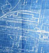
Southern Pacific Lines San Francisco Calif.
Station Plan of Millbrae San Mateo County CA
San Francisco Calif.: Southern Pacific Company 1923 rev. 1931. Blueprint 24" x 56". From beyond Chadbourne Avenue and State Highway approx 1 mile to the southeast. With Schedule of Property listing 18 transfers 1862-1899. Includes West Coast Porcelain Mfg Buri Buri Rancho few buildings along railroad tracks. Scale 1" = 100'. San Francisco, Calif.: Southern Pacific Company, 1923, rev. 1931 unknown
Referentie van de boekhandelaar : 56-0410
|
|
|
Southern Pacific Lines San Francisco Calif.
Station Plan of Alturas Modoc County CA
San Francisco Calif.: Southern Pacific Company 1957 rev. 1962. Blackline print 24" x 56". Sheet one of two. With railroad yard listed including descriptions of buildings no other structures present. Including railroad lines private crossings and US highway 395. Scale 1" = 100'. San Francisco, Calif.: Southern Pacific Company, 1957, rev. 1962 unknown
Referentie van de boekhandelaar : 56-0389

|
|
|
Southern Pacific Lines San Francisco Calif.
Station Plan of Redwood Junction San Mateo County CA
San Francisco Calif.: Southern Pacific Company 1928 rev. 1929. Blueprint 24 inches x 56 inches. From Pacific Avenue to Twelfth Avenue Middlefield Road to Fair Oaks Avenue. Includes Union Oil Company Golden State Mushroom Compan North Fair Oaks. Scale 1" = 100'. San Francisco, Calif.: Southern Pacific Company, 1928, rev. 1929 unknown
Referentie van de boekhandelaar : 58-0470

|
|
|
Southern Pacific Lines San Francisco Calif.
Station Plan of Polk Railroad Yard Sacramento Sacramento County California
Sacramento Calif.: Pacific Motor Trucking Company 1948. Revised 1961. Map. Blueline print 12" x 56". Along West Railroad Ave near Power Inn Road intersection. Includes Brighton Park Black Diamond Lumber Co Alex Enghardt Roofing Valley Crane Service. Scale approx 1" = 100'. Sacramento, Calif.: Pacific Motor Trucking Company, 1948. Revised 1961 unknown
Referentie van de boekhandelaar : 56-0364

|
|
|
Southern Pacific Lines San Francisco Calif.
Station Plan of Oakdale Stanislaus County California. Set of Two. Map
Oakland Calif.: Southern Pacific Company 1930. Map. Blueprints each 24" x 55". Station plan of Oakdale railroad property with approx. four blocks on each side along tracks from north of Stanislaus River to south of South St. Scale 1" = 100'. Oakland, Calif.: Southern Pacific Company, 1930 unknown
Referentie van de boekhandelaar : 56-0241

|
|
|
Southern Pacific Lines San Francisco Calif.
Station Plan of Page/Albany Linn County Ore
Portland Ore.: Southern Pacific Company 1946 rev. 1948. Blueline print 24" x 56". Title is printed "Page" with "Albany" lightly printed over same position. From County Road 21/55 to 15th Street and Ferry Street to US 99E/Pacific Highway. Includes John Millard's Land Plat station point Page Albany Ice & Cold Storage Forest Furniture Hudson-Duncan & Co. Scale 1" = 100'. Portland, Ore.: Southern Pacific Company, 1946, rev. 1948 unknown
Referentie van de boekhandelaar : 56-0386
|
|
|
Southern Pacific Lines San Francisco Calif.
Station Plan of South San Francisco San Mateo County California
San Francisco Calif.: Southern Pacific Company 1924 revised 1947. Map. Blueline print 24" x 55". From Orange Ave to Linden Ave/Bayshore Hwy and Baden Ave to approx 1/4 mile south of Railroad Ave. Includes Guy F. Atkinson plots Pacific Coast Wrecking and Salvage Co South City Lumber and Supply Co. Scale 1" = 100'. San Francisco, Calif.: Southern Pacific Company, 1924, revised 1947 unknown
Referentie van de boekhandelaar : 56-0319

|
|
|
Southern Pacific Lines San Francisco Calif.
Station Plan of Redwood City San Mateo County CA
San Francisco Calif.: Southern Pacific Company 1938 rev. 1952. Blueline print 16 inches x 21 inches. Yard limits indicated in red highlighting. From approx 1/2 mile beyond yard limits east and west two miles north. Scale 5 inches = 1 mile. San Francisco, Calif.: Southern Pacific Company, 1938, rev. 1952 unknown
Referentie van de boekhandelaar : 58-0473

|
|
|
Southern Pacific Lines San Francisco Calif.
Station Plan of Bernal San Francisco County CA
San Francisco Calif.: Southern Pacific Company 1931. Blueprint 24 inches x 55 inches. From Holly Park Circle 30th Street and Chenery Street to Acadia Street and Monterey Street. Includes station point Bernal Ray Burner Co. Scale 1 inch = 100 feet. San Francisco, Calif.: Southern Pacific Company, 1931 unknown
Referentie van de boekhandelaar : 58-0515

|
|
|
Southern Pacific Lines San Francisco Calif.
Station Plan of Cartago Inye County AZ
San Francisco Calif.: Southern Pacific Company 1931 rev. 1942. Blueprint 24 inches x 70 inches. From 1600 feet south of Inyo County Company Tracks to 1500 feet north of abandoned Cartago piping and water supplies building. Includes few buildings primarily track measurements. Scale 1 inch = 100 feet. San Francisco, Calif.: Southern Pacific Company, 1931, rev. 1942 unknown
Referentie van de boekhandelaar : 58-0518

|
|
|
Southern Pacific Lines San Francisco Calif.
Station Plan of Redwood Harbor Spur San Mateo County CA
San Francisco Calif.: Southern Pacific Company 1925 rev. 1944. Blueline print 24 inches x 56 inches. From Stauffer one mile north into Salt Marshes. With Salt Ponds Salt Marshes Plant Rubber & Asbestos Coom P.G. & E. Steinberger Slough station point Stauffer. Scale 1 inch = 100 feet. San Francisco, Calif.: Southern Pacific Company, 1925, rev. 1944 unknown
Referentie van de boekhandelaar : 58-0475

|
|
|
Southern Pacific Lines San Francisco Calif.
Station Plan of Bakersfield Kern County CA
San Francisco Calif.: Southern Pacific Company 1932. Blueline print 48 inches x 20 feet. From 26th Street and US Highway 99 to Pentz Street along railroad tracks with details of buildings within 1000 feet in each direction of railroad lines. Scale 1" = 100'. With insert detailing Garces Circle and old Kern County Fair Grounds. San Francisco, Calif.: Southern Pacific Company, 1932 unknown
Referentie van de boekhandelaar : 56-0400

|
|
|
Southern Pacific Lines San Francisco Calif.
Station Plan for Henderson San Mateo County California. Map
San Francisco Calif.: Southern Pacific Company 1962. Map. Blueline print 24" x 83" From Belle Haven to Spring Valley Water Co. Includes Midway Supply and Salvage Co. Minimal details besides power lines and railroad line measurements and signs. Scale 1" = 100'. San Francisco, Calif.: Southern Pacific Company, 1962 unknown
Referentie van de boekhandelaar : 56-0271
|
|
|
Southern Pacific Lines San Francisco Calif.
Station Plan of Agnew Santa Clara County CA
San Francisco Calif.: Southern Pacific Company 1957 rev. 1961. Blueline print 24" x 56". Sheet one of three. From Fifth Street North to beyond Montague Road along Alviso Santa Clara Road and railroad tracks. Includes Agnew State Hospital corral PG & E transformer yard. Scale 1" = 100'. San Francisco, Calif.: Southern Pacific Company, 1957, rev. 1961 unknown
Referentie van de boekhandelaar : 56-0377

|
|
|
Southern Pacific Lines San Francisco Calif.
Station Plan of West Alameda Alameda County CA
Oakland Calif.: Southern Pacific Company 1949 rev. 1959. Blueline print 24" x 56". Sheet two of two. From US Naval Air Station entrance to Main Street and Todd Shipyards Corporation. Includes US Naval Air Station with Officer's Quarters and Club Oakland Estuary Todd Shipyards Company. Scale 1" = 100'. Oakland, Calif.: Southern Pacific Company, 1949, rev. 1959 unknown
Referentie van de boekhandelaar : 56-0382

|
|
|
Southern Pacific Lines San Francisco Calif.
Station Plan of Del Monte Monterey County California. Map
San Francisco Calif.: Southern Pacific Company 1931. Map. Blueline print 24" x 56". Map of Del Monte CA. Includes El Estero Oak Grove Addition Lake switching points. Scale 1" = 100'. San Francisco, Calif.: Southern Pacific Company, 1931 unknown
Referentie van de boekhandelaar : 56-0248

|
|
|
Southern Pacific Lines San Francisco Calif.
Station Plan of Army Point Solano County CA
Oakland Calif.: Southern Pacific Company 1927 rev. 1947. Blueline print 24" x 56". From East Sixth Street to Benicia Junction. Includes Straits of Carquinez Benicia Arsenal Army Point station point Maia Point abandoned station Yuba Co Macadam Roadway Wharf. Scale 1" = 100'. Oakland, Calif.: Southern Pacific Company, 1927, rev. 1947 unknown
Referentie van de boekhandelaar : 56-0394

|
|
|
Southern Pacific Lines San Francisco Calif.
Station Plan of Salem Marion County Oregon
San Francisco Calif.: Southern Pacific Company 1947 rev. 1955. Blueline print 24 inches x 56 inches red and green pencilling. From Rosemont Street and Williamette River to 9th Street and Wallace Road. Includes Kingwood Park Addition Blue Lake Cannery National Battery Company. Scale 1 inch = 100 feet. San Francisco, Calif.: Southern Pacific Company, 1947, rev. 1955 unknown
Referentie van de boekhandelaar : 58-0560

|
|
|
Southern Pacific Lines San Francisco Calif.
Station Plan of Oakdale Stanislaus County California. Set of Two. Map
Oakland Calif.: Southern Pacific Company 1930 revised 1960. Map. Blueline prints each 25" x 56". Station plan of Oakdale railroad property with approx. four blocks on each side along tracks from north of Stanislaus River to south of South St. Scale 1" = 100'. Oakland, Calif.: Southern Pacific Company, 1930, revised 1960 unknown
Referentie van de boekhandelaar : 56-0240

|
|
|
Southern Pacific Lines San Francisco Calif.
Station Plan of Redwood City San Mateo County CA
San Francisco Calif.: Southern Pacific Company 1924 rev. 1952. Blueline print 24 inches x 56 inches. From Winslow Avenue to Charter Street. Includes station points Redwood City and Redwood Junction Eastern Addition Hancock Addition Diller's Addition Davies Chevrolet. Scale 1 inch = 100 feet. San Francisco, Calif.: Southern Pacific Company, 1924, rev. 1952 unknown
Referentie van de boekhandelaar : 58-0478

|
|
|
Southern Pacific Lines San Francisco Calif.
Station Plan of West of Auburn Placer County CA - Westward Track
Sacramento Calif.: Southern Pacific Company 1947. Blueline print 24" x 56". From Sacramento Street to beyond Virginia Street and Davenport Subdivision. Includes Bernhard Subdivision College Heights and College Heights Extension Texaco Oil Standard Oil Telephone Co Associated Oil Henny & Berquist Contractors. Scale 1" = 100'. Sacramento, Calif.: Southern Pacific Company, 1947 unknown
Referentie van de boekhandelaar : 56-0396
|
|
|
Southern Pacific Lines San Francisco Calif.
Station Plan of Monterey Monterey County California. Map
San Francisco Calif.: Southern Pacific Company 1931. Map. Blueline print 24" x 56". Map of Monterey CA. Includes Laguna Monterey Presidio Military Reservation Monterey Bay San Carlos Canning Co E.B. Gross Canning Co. Scale 1" = 100'. San Francisco, Calif.: Southern Pacific Company, 1931 unknown
Referentie van de boekhandelaar : 56-0250

|
|
|
Southern Pacific Lines San Francisco Calif.
Station Plan of Benicia Solano County California
Oakland Calif.: Southern Pacific Company 1948 rev 1960. Blueline print 24" x 56". From West Third Street to East Sixth Street E Street to Union Street. Includes Kullman Salz & Co American Sardine River Steamer Landing Benicia Food Products Co Plant Martinez-Benicia Auto Ferry. Scale 1" = 100'. Oakland, Calif.: Southern Pacific Company, 1948, rev 1960 unknown
Referentie van de boekhandelaar : 56-0403

|
|
|
Southern Pacific Lines San Francisco Calif.
Station Plan of Madera Madera County California. Map
San Francisco Calif.: Southern Pacific Company 1926 revised 1949. Map. Blueline print 24" x 56" notes indicate "Sheet 1 of 3." Includes Fresno River Johnsons Addition town of Madera between Central Ave and Third Street and between C Street and H street. Scale 1" = 100'. San Francisco, Calif.: Southern Pacific Company, 1926, revised 1949 unknown
Referentie van de boekhandelaar : 56-0277

|
|
|
Southern Pacific Lines San Francisco Calif.
Station Plan of Alturas Modoc County CA
San Francisco Calif.: Southern Pacific Company 1940. Blackline print 24" x 56". Sheet two of two. From Pit River to 1700' east of Alturas station. Includes Alturas station point Willow Park Subdivision State Highway Mary C. Miller plot PS Dorris plot Churchill Street. Scale 1" = 100'. San Francisco, Calif.: Southern Pacific Company, 1940 unknown
Referentie van de boekhandelaar : 56-0391

|
|
|
Southern Pacific Lines San Francisco Calif.
Station Plan of Stockton Fresno County California
San Francisco Calif.: Southern Pacific Company 1926. Map. Blueline print 24" x 55" with red and black pencil. From Little John Creek and French Camp Slough to beyond French Camp crossing. Includes Sperry Flour Western Lumber Sales Co Mosswood Park. Scale approx. 1" = 100'. San Francisco, Calif.: Southern Pacific Company, 1926 unknown
Referentie van de boekhandelaar : 56-0335

|
|
|
Southern Pacific Lines San Francisco Calif.
Station Plan of Tempe Maricopa County Arizona. Map
San Francisco Calif.: Southern Pacific Company 1931. Map. Blueline print 24" x 55". Includes Salt River station points Tempe and Tempe Junction. Includes Schedule of Property with approx 20 transfers 1875-1931. Scale 1" = 400' San Francisco, Calif.: Southern Pacific Company, 1931 unknown
Referentie van de boekhandelaar : 56-0341

|
|
|
Southern Pacific Lines San Francisco Calif.
Station Plan of Redwood Harbor Spur San Mateo County CA
San Francisco Calif.: Southern Pacific Company 1925 rev. 1944. Blueline print 24 inches x 56 inches. From Redwood City Harbor Company to West Point Creek. Includes Redwood City Harbor Co Pacific Portland Cement Co Redwood Creek West Point Creek city of Redwood City station point Redwood Harbor. Scale 1 inch = 100 feet. San Francisco, Calif.: Southern Pacific Company, 1925, rev. 1944 unknown
Referentie van de boekhandelaar : 58-0476

|
|
|
Southern Pacific Lines San Francisco Calif.
Station Plan of Alameda Alameda County California - Webster St.
Oakland Calif.: Southern Pacific Company 1945 rev. 1961. Blueline print 24" x 62". From Estuary and Pierhead line to Eagle Avenue along Webster Street. Includes Air Force Intransit Depot Federal Housing Authority Bethlehem Shipbuilding Corporation Associated Oil Company. Scale: 1" = 100'. Oakland, Calif.: Southern Pacific Company, 1945, rev. 1961 unknown
Referentie van de boekhandelaar : 56-0380

|
|
|
Southern Pacific Lines San Francisco Calif.
Station Plan of Abatto and Los Banos Merced County CA
Stockton Calif.: Southern Pacific Company 1928 rev. 1941. Blueline print 24 inches x 13 feet. Three maps joined securely. From 3400' west of First Street Los Banos to 3000' east of Abatto along railroad tracks. With 6" tear no missing material. Details of all industries along railroad tracks. Including Los Banos Lumber & Supply Co Standard Oil Co Central California Creameries. Scale 1" = 100'. Stockton, Calif.: Southern Pacific Company, 1928, rev. 1941 unknown
Referentie van de boekhandelaar : 56-0469

|
|
|
Southern Pacific Lines San Francisco Calif.
Station Plan of Redwood City San Mateo County CA
San Francisco Calif.: Southern Pacific Company 1925 rev. 1937. Blueprint 24 inches x 56 inches. From St. Francis Way to Broadway and Winslow Street. Includes Mezesville Wellesley Park Dingee Park Pacific Gas and Electric Standard Oil Co. Proposed lease limits to Redwood City for fence and cultivation purposes. Scale 1" = 100'. San Francisco, Calif.: Southern Pacific Company, 1925, rev. 1937 unknown
Referentie van de boekhandelaar : 58-0471

|
|
|
Southern Pacific Lines San Francisco Calif.
Station Plan of Fresno San Joaquin County California. Map
San Francisco Calif.: Southern Pacific Company 1946. Map. Blueline print 24" x 220". Detailed map of Fresno along railroad lines from Roeding Park to Atchison Topeka and Santa Fe building at California Ave and Belgravia Ave. Scale 1" = 100'. San Francisco, Calif.: Southern Pacific Company, 1946 unknown
Referentie van de boekhandelaar : 56-0268

|
|
|
Southern Pacific Lines San Francisco Calif.
Station Plan of Chico Butte County CA
San Francisco Calif.: Southern Pacific Company 1947 rev. 1961. Blueline print 24" x 56". No buildings described other than General Office and Section Foreman. Includes signal descriptions within railroad yard Del Norte Street. Scale 1" = 100'. San Francisco, Calif.: Southern Pacific Company, 1947, rev. 1961 unknown
Referentie van de boekhandelaar : 56-0414

|
|
|
Southern Pacific Lines San Francisco Calif.
Station Plan of Dyer. Map
San Francisco Calif.: Southern Pacific Los Angeles Division 1934. Map. Scale: 1 inch = 100 feet. Blueprint. August 4 1943. San Francisco, Calif.: Southern Pacific, Los Angeles Division, 1934 unknown
Referentie van de boekhandelaar : 01-0056
|
|
|
Southern Pacific Lines San Francisco Calif.
Station Plan of Los Medanos Contra Costa County California. Map
San Francisco Calif.: Southern Pacific Company 1949 revised 1954. Map. Blueline print 24" x 36" with pencil notation. Includes State Highway 4 & 24 Standard Oil Co Camp Stoneman U.S. Government building. Scale 1" = 100' San Francisco, Calif.: Southern Pacific Company, 1949, revised 1954 unknown
Referentie van de boekhandelaar : 56-0281

|
|
|
Southern Pacific Lines San Francisco Calif.
Station Plan of Turlock Stanislaus County California. Map
San Francisco Calif.: Southern Pacific Company 1926 revised 1940. Map. Blueprint 24" x 55". From State Highway and State Highway crossing to Orchard Street Geer Avenue. Includes Smithland Farm tract Carl Peterson tract Levard Park. Scale 1" = 100'. San Francisco, Calif.: Southern Pacific Company, 1926, revised 1940 unknown
Referentie van de boekhandelaar : 56-0347

|
|
|
Southern Pacific Lines San Francisco Calif.
Station Plan of Phoenix Arizona West. Map
Tucson Ariz.: Southern Pacific Company 1947 revised 1950. Map. Blackline print. 24 x 164 inches. Very detailed map of West Phoenix from Ninth Avenue to Thirty-Fifth Avenue including names of plot owners and businesses. Scale: 1 inch = 100 feet. Tucson, Ariz.: Southern Pacific Company, 1947, revised 1950 unknown
Referentie van de boekhandelaar : 56-0219

|
|
|
Southern Pacific Lines San Francisco Calif.
Station Plan of Chowchilla Branch Madera County CA
San Francisco Calif.: Southern Pacific Company 1930 rev. 1949. Blueline print 24" x 56" with red pencilling indicating switching limits. From Front Street to Thirteenth Street and Humboldt Avenue to Madera County Fair Grounds. WIth San Joaquin Cotton Oil Co New Fertilizer Plant Sun Maid Raisin Growers Griffin & Trout. Scale 1" = 100'. San Francisco, Calif.: Southern Pacific Company, 1930, rev. 1949 unknown
Referentie van de boekhandelaar : 56-0417

|
|
|
Southern Pacific Lines San Francisco Calif.
Station Plan of Brighton Sacramento Sacramento County CA
Sacramento Calif.: Southern Pacific Company 1946 Rev 1952. Blueline print 24" x 56". From beyond Folsom Boulevard and 65th Street to Sutter Avenue and Railroad Avenue. Includes Brighton townsite Sacramento Box and Lumber McGillvray Construction A Teichert and Sons Contractors Harelson Feed. Scale 1" = 100'. Sacramento, Calif.: Southern Pacific Company, 1946, Rev 1952 unknown
Referentie van de boekhandelaar : 56-0406

|
|
|
Southern Pacific Lines San Francisco Calif.
Station Plan of West Alameda Alameda County CA
Oakland Calif.: Southern Pacific Company 1947 rev. 1960. Blueline print 24" x 56". Sheet one of two. From Main Street to Webster Street and Singleton Avenue to US Pierhead Line. Includes Air Force Intransit Depot Federal Housing Authority Todd Shipyards Company Associated Oil Company. Scale 1" = 100'. Oakland, Calif.: Southern Pacific Company, 1947, rev. 1960 unknown
Referentie van de boekhandelaar : 56-0381

|
|
|
Southern Pacific Lines San Francisco Calif.
Station Plan of West Visalia Tulare County California
San Francisco Calif.: Southern Pacific Company 1925 revised 1929. Map. Blueprint 12" x 55". From beyond western City Limits to Flora Street. Includes California Packing Corp California Fruit Cannery Association Associated Oil Co. Scale 1" = 100'. San Francisco, Calif.: Southern Pacific Company, 1925, revised 1929 unknown
Referentie van de boekhandelaar : 56-0354

|
|
 De zoekresultaten per email ontvangen
 Zoekresultaten downloaden als PDF
 RSS feed


