|
Southern Pacific Lines (San Francisco, Calif).
Right of Way and Track Map San Jose to Vasona Santa Clara County CA.
San Francisco Calif.: Southern Pacific Company 1942 rev. 1960. Blackline print 24 inches x 55 inches. From Kearney Street and Park Avenue to 4000 feet beyond Fruitvale Avenue along railroad track. With San Jose Brick Company Sainsevaine Villa. With Schedule of Property listing approx 75 transfers 1877-1960. Scale 1 inch = 200 feet. San Francisco, Calif.: Southern Pacific Company, 1942, rev. 1960. unknown
Referentie van de boekhandelaar : 58-0535

|
|
|
Southern Pacific Lines (San Francisco, Calif).
Right of Way and Track Map of Ostrom Yuba County California.
San Francisco Calif.: Southern Pacific Company 1962. Map. Blueline print. 24 x 56 inches. Map of Ostrom including Olivehurst Tract Subdivision with Schedule of Property Acquisition Date Original Grantor/Grantee Instrument of Transfer and Remarks of Sale for 3 transfers 1866-1915. Scale: 1 inch = 400 feet. San Francisco, Calif.: Southern Pacific Company, 1962. unknown
Referentie van de boekhandelaar : 56-0224

|
|
|
Southern Pacific Lines (San Francisco, Calif).
Right of Way and Track Map Santa Cruz to Davenport Santa Cruz County California.
San Francisco Calif.: Southern Pacific Company n.d. Map. Blueline print 24" x 55" with red pencil indicating switching limits. From Cliff Drive to the west to Bay of Monterey and Bay St to the east. Scale 1" = 200'. Includes inset Index map of area with Rancho Refugio scale 1 inch = 1 mile. San Francisco, Calif.: Southern Pacific Company, [n.d.] unknown
Referentie van de boekhandelaar : 56-0303

|
|
|
Southern Pacific Lines (San Francisco, Calif).
RIght of Way and Track Map Giant Contra Costa County CA
San Francisco Calif.: Southern Pacific Company n.d. Blueline print 24" x 55". From approx one mile south of station point Giant to station point Giant. No structures other than station and warehouse indicated map primarily details track measurements and signals. Includes Schedule of Property listing 12 transfers 1873-1894. Scale 1" = 100'. San Francisco, Calif.: Southern Pacific Company, [n.d.] unknown
Referentie van de boekhandelaar : 56-0441

|
|
|
Southern Pacific Lines (San Francisco, Calif).
Right of Way and Track Map of San Mateo San Mateo County CA.
San Francisco Calif.: Southern Pacific Company n.d. Blackline print 24 inches x 56 inches. From Lincoln Avenue to Grand Boulevard Crossway Road to Bayshore Highway. Includes station points Broadway and Burlingame Buri Buri Burlingame Grove Lyon & Hoag Subdivision San Mateo Heights. Scale 1 inch = 200 feet. San Francisco, Calif.: Southern Pacific Company, [n.d.] unknown
Referentie van de boekhandelaar : 58-0526

|
|
|
Southern Pacific Lines (San Francisco, Calif).
Right of Way and Track Map of Tempe Maricopa County Arizona.
San Francisco Calif.: Southern Pacific Company 1936. Map. Blueline print 24" x 55". Includes Normal Junction Alma School. Map is primarily railroad track with measurement markings. Includes Schedule of Property with 30 transfers 1903-1936. Scale 1" = 400'. San Francisco, Calif.: Southern Pacific Company, 1936. unknown
Referentie van de boekhandelaar : 56-0343

|
|
|
Southern Pacific Lines (San Francisco, Calif).
Right of Way and Track Map of Benecia and Army Point Solano County CA.
San Francisco Calif.: Southern Pacific Company n.d. Blueline print 24 inches x 55 inches. From Contra Costa County Line past Benecia along railroad tracks to 4000 feet beyond edge of Army Point. With US Military Reservation Land Suisun Bay. Scale 1 inch = 400 feet. Includes Index Map of main Southern Pacific line from Benecia to Sacramento scale 1 inch = 2 miles. San Francisco, Calif.: Southern Pacific Company, [n.d.] unknown
Referentie van de boekhandelaar : 58-0536

|
|
|
Southern Pacific Lines (San Francisco, Calif).
Right of Way and Track Map of Salinas Monterey County California.
San Francisco Calif.: Southern Pacific Company n.d. Blueline print 24 x 56 inches. Yard and switching limits indicated in black and green pencil. From Bolsa de Scorpinas to Rincon del Sanjon Racho. Includes Station Point Cooper Bolsa del Potrero y Morocojo. No structures shown. With Schedule of Property listing 3 transfers 1872. Scale: 1 inch = 400 feet. San Francisco, Calif.: Southern Pacific Company, [n.d.] unknown
Referentie van de boekhandelaar : 58-0554

|
|
|
Southern Pacific Lines (San Francisco, Calif).
Right of Way and Track Map of Albany - Toledo Linn & Benton Counties OR.
San Francisco Calif.: Southern Pacific Company 1932. Blueline print 24 inches x 55 inches. From approx 2 miles northwest of Albany to southeastern Albany city limits. Includes map of Albany with all streets and structrues. With Schedule of Property listing approx 55 transfers 1886-1932. Scale 1 inch = 400 feet. San Francisco, Calif.: Southern Pacific Company, 1932. unknown
Referentie van de boekhandelaar : 58-0548

|
|
|
Southern Pacific Lines (San Francisco, Calif).
Right of Way and Track Map. Port Chicago Contra Costa County California.
San Francisco Calif.: Southern Pacific Company 1955. Map. Blueline print. 24 x 35 inches. Includes Port Chicago site of famous 1944 Port Chicago Naval Disaster Hastings Slough Bridge C.A. Smith Lumber Co. With Schedule of Property Acquisition Date Original Grantor/Grantee Instrument of Transfer and Remarks of Sale for approximately 35 transfers 1873-1955. Scale: 1 inch = 400 feet. Photo of detail. San Francisco, Calif.: Southern Pacific Company, 1955. unknown
Referentie van de boekhandelaar : 56-0205

|
|
|
Southern Pacific Lines (San Francisco, Calif).
Right of Way and Track Map of Yuma Yuma County Arizona.
Los Angeles Calif.: Southern Pacific Company 1950. Map. Blueline print 24" x 60". Includes City of Yuma with detailed railroad yard Southwestern Ice & Cold Storage Co Ice Plant Union Oil Company. From Colorado River to beyond Seventh Street. Scale 1" = 100'. Los Angeles, Calif.: Southern Pacific Company, 1950. unknown
Referentie van de boekhandelaar : 56-0359
|
|
|
Southern Pacific Lines (San Francisco, Calif).
Right of Way and Track Map Watsonville Junction to Santa Cruz Santa Cruz County California.
San Francisco Calif.: Southern Pacific Company n.d. Map. Blueline print 24" x 55" with red pencil indicating switching limits. Includes station points Santa Cruz Casino Seabright Cliffside. Scale 1" = 400'. San Francisco, Calif.: Southern Pacific Company, [n.d.] unknown
Referentie van de boekhandelaar : 56-0301

|
|
|
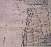
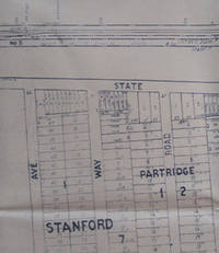
Southern Pacific Lines (San Francisco, Calif).
Right of Way and Track Map for Palo Alto and Vicinity California.
San Francisco Calif.: Southern Pacific Company 1939. Map. Blueline print. 24 x 56 inches. With orange and red pencilled notes. Map of Palo Alto from Menlo Avenue to Churchill Avenue including Stanford University. With Schedule of Property Acquisition Date Original Grantor/Grantee Instrument of Transfer and Remarks of Sale for approximately 25 transfers 1863-1939. Scale: 1 inch = 200 feet. San Francisco, Calif.: Southern Pacific Company, 1939. unknown
Referentie van de boekhandelaar : 56-0220
|
|
|
Southern Pacific Lines (San Francisco, Calif).
Right of Way and Track Map - San Bruno to San Francisco San Mateo County California. Map.
San Francisco Calif.: Southern Pacific Company 1954. Map. Blackline print 24" x 55" with pencil sketch of Spruce Ave. Includes Buri Buri Rancho San Mateo Ave station point Tanforan. With Schedule of Purchase listing approx 30 transfers 1862-1954. Scale 1" = 200'. San Francisco, Calif.: Southern Pacific Company, 1954. unknown
Referentie van de boekhandelaar : 56-0310

|
|
|
Southern Pacific Lines (San Francisco, Calif).
Right of Way and Track Map of Lodi - Woodbridge to Valley Spring San Joaquin County CA
San Francisco Calif.: Southern Pacific Company 1936. Blueline print 24" x 56". Sheet two of three. Switching limits indicated in orange green blue and red pencil. From Chestnut Street to Cherokee Lane. Includes station point Woodbridge Burr's Addition Lawrence Homestead. With Schedule of Property listing approx 60 transfers 1882 - 1936. Scale 1" = 400'. With inset map Woodbridge to Valley Sprint scale 1 inch = 2 miles. San Francisco, Calif.: Southern Pacific Company, 1936. unknown
Referentie van de boekhandelaar : 56-0459

|
|
|
Southern Pacific Lines (San Francisco, Calif).
Right of Way and Track Map of Sacramento and Vicinity Sacramento County CA.
San Francisco Calif.: Southern Pacific Company 1950. Blueline print 34 inches x 67 inches. From Sacramento City Park beyond Marconi Avenue and Auburn Boulevard along railroad tracks. With Rancho Del Paso station points Swanston Haggin Benali. Includes Schedule of Property listing 18 transfers 1865-1950. Scale 1 inch = 400 feet. San Francisco, Calif.: Southern Pacific Company, 1950 unknown
Referentie van de boekhandelaar : 58-0511

|
|
|
Southern Pacific Lines (San Francisco, Calif).
Right of Way and Track Map of Alturas Modoc County CA.
San Francisco Calif.: Southern Pacific Company n.d. Blueline print 24 inches x 55 inches. From approx 2 miles south of North fork of Pitt River to outer city limits of Alturas. With all streets along tracks in Alturas. Scale 1 inch = 400 feet. San Francisco, Calif.: Southern Pacific Company, [n.d.] unknown
Referentie van de boekhandelaar : 58-0544

|
|
|
Southern Pacific Lines (San Francisco, Calif).
Right of Way and Track Map Santa Cruz to Davenport Santa Cruz County California.
San Francisco Calif.: Southern Pacific Company 1953. Map. Blueline print 24" x 55" with red pencil indicating switching limits. From Meder Creek to the west to Cliff Drive to the east. Includes Rancho Refugio. With Schedule of Property listing 9 transfers 1905-1953. Scale 1" = 200'. San Francisco, Calif.: Southern Pacific Company, 1953. unknown
Referentie van de boekhandelaar : 56-0305

|
|
|
Southern Pacific Lines (San Francisco, Calif).
Right of Way and Track Map of Auburn Sacramento County CA.
San Francisco Calif.: Southern Pacific Company 1956. Blueline print 24 inches x 55 inches. Both tracks through Auburn detailed in full. Includes Station points Auburn - Nevada Street Auburn abandoned station Flint. With some structures along track in downtown. Scale 1 inch = 400 feet. San Francisco, Calif.: Southern Pacific Company, 1956. unknown
Referentie van de boekhandelaar : 58-0539

|
|
|
Southern Pacific Lines (San Francisco, Calif).
Right of Way and Track Map of Spreckels Junction Salinas Monterey County CA.
San Francisco Calif.: Southern Pacific Company 1948. Blueline print 24 inches x 56 inches. From Nacional Rancho to approx 4 miles southeast. Includes Station Point Spreckels Junction Llano de Buena Vista Rancho. With Schedule of Property listing approx 25 transfers 1872-1948. Scale 1 inch = 400 feet. San Francisco, Calif.: Southern Pacific Company, 1948. unknown
Referentie van de boekhandelaar : 58-0556

|
|
|
Southern Pacific Lines (San Francisco, Calif).
Right of Way and Track Map of Mountain View Santa Clara County California.
San Francisco Calif.: Southern Pacific Company 1935. Map. Blueline print 24" x 56". Map of Mountain View CA with Switching Limits. Includes zoned highway acres Bonita Tract subdivision. W/ Schedule of Property approx. 10 transfers 1864-1935. Scale 1" = 200'. San Francisco, Calif.: Southern Pacific Company, 1935. unknown
Referentie van de boekhandelaar : 56-0246
|
|
|
Southern Pacific Lines (San Francisco, Calif).
Right of Way and Track Map of Butte County CA.
San Francisco Calif.: Southern Pacific Company 1934. Blackline print 24 inches x 55 inches. No structures or industries indicated map consists primarily of railroad track signals and measurements. With Schedule of Property indicating approx 10 transfers 1866-1934. Scale 1 inch = 400 feet. San Francisco, Calif.: Southern Pacific Company, 1934. unknown
Referentie van de boekhandelaar : 58-0530

|
|
|
Southern Pacific Lines (San Francisco, Calif).
Right of Way and Track Map Palo Alto Main Line Mayfield Santa Clara County California.
San Francisco Calif.: Southern Pacific Company 1938. Map. Blueline print. 24 x 56 inches. With red and orange pencilling. Map of Mayfield from Churchill Avenue to Diss Road. Includes Sunnyside and Evergreen Park. With Schedule of Property Acquisition Date Original Grantor/Grantee Instrument of Transfer and Remarks of Sale for approximately 26 transfers 1864-1938. Scale 1 inch = 200 feet. San Francisco, Calif.: Southern Pacific Company, 1938. unknown
Referentie van de boekhandelaar : 56-0222

|
|
|
Southern Pacific Lines (San Francisco, Calif).
Right of Way and Track Map of Tempe Maricopa County Arizona.
San Francisco Calif.: Southern Pacific Company 1957. Map. Blueline print 24" x 55". Includes Normal Junction Tempe Junction. Map is primarily railroad track with measurement markings with some numbered buildings at Tempe Junction. Includes Schedule of Property with 10 transfers 1926-1957. Scale 1" = 400'. San Francisco, Calif.: Southern Pacific Company, 1957. unknown
Referentie van de boekhandelaar : 56-0344

|
|
|
Southern Pacific Lines (San Francisco, Calif).
Right of Way and Track Map of Albany Linn County Ore.
Portland Ore.: Southern Pacific Company n.d. Blueline print 24 inches x 55 inches. From Isaac Hutchins Donation Land Claim at southwest corner of Albany to Exum Powell claim beyond 2nd standard Parallel south. With Williamette River all streets within Albany city limits. Scale 1 inch = 400 feet. Portland, Ore.: Southern Pacific Company, [n.d.] unknown
Referentie van de boekhandelaar : 58-0543

|
|
|
Southern Pacific Lines (San Francisco, Calif).
Right of Way and Track Map Watsonville Junction to Olympia Santa Cruz County California.
San Francisco Calif.: Southern Pacific Company 1937. Map. Blueline print 24" x 55" with red pencil indicating switching limits. Includes Rancho de la Canada de Rincon discontinued station point Golf Links. From approx 4000' northwest of Golf Links to Coral St to the south-east. With schedule of Property listing appox 10 transfers 1875-1937. Scale 1" = 200'. San Francisco, Calif.: Southern Pacific Company, 1937. unknown
Referentie van de boekhandelaar : 56-0304

|
|
|
Southern Pacific Lines (San Francisco, Calif).
Right of Way and Track Map from Binney Junction to Oroville Butte County California.
San Francisco Calif.: Southern Pacific Company 1920. Map. Blueline print. 24 x 56 inches. Folded with red pencilling. Map from Binney Junction to Oroville with Schedule of Property Acquisition Date Original Grantor/Grantee Instrument of Transfer and Remarks of Sale for 15 transfers 1852-1915. Scale: 1 inch = 400 feet. San Francisco, Calif.: Southern Pacific Company, 1920. unknown
Referentie van de boekhandelaar : 56-0225

|
|
|
Southern Pacific Lines (San Francisco, Calif).
Right of Way and Track Map Pabrico Alameda County California.
San Francisco Calif.: Calif. Southern Pacific Company 1926. Map. Blueprint 24" x 55". Complete map of Pabrico. Includes W.S. Dickey Clay Co. K. & L. Box Co. Scale 1" = 100'. San Francisco, Calif.:, Calif. Southern Pacific Company, 1926. unknown
Referentie van de boekhandelaar : 56-0245

|
|
|
Southern Pacific Lines (San Francisco, Calif).
Right of Way and Track Map of Firebaugh and Vicinity Fresno County California.
San Francisco Calif.: Southern Pacific Company 1957. Map. Blueline print 24" x 55". Includes San Joaquin River station point Firebaugh with 35 buildings Miller and Lux subdivision plot. With Schedule of Property listing approx. 20 transfers 1888-1957. Scale 1" = 400'. San Francisco, Calif.: Southern Pacific Company, 1957. unknown
Referentie van de boekhandelaar : 56-0326

|
|
|
Southern Pacific Lines (San Francisco, Calif).
Right of Way and Track Map of Luning Mineral County Nevada.
San Francisco Calif.: Southern Pacific Company 1929. Map. Blueline print 24" x 56". Railroad track map of Luring and vicinity. Includes Shedule of Property of record of 5 transfers 1875-1929. Scale 1" = 400'. Includes small inset detail map of Luning no scale indicated. San Francisco, Calif.: Southern Pacific Company, 1929. unknown
Referentie van de boekhandelaar : 56-0279

|
|
|
Southern Pacific Lines (San Francisco, Calif).
Right of Way and Track Map of Barton Amador County CA and Vicinity
San Francisco Calif.: Southern Pacific Company 1927. Blueline print 24" x 65" and 6" x 8" addition with red lines indicating switching points. Detail of additional map affixed to original to indicate switching limits. From Fresno Avenue No. 8 to Las Palmas. With portion of Schedule of Propoerty approx. 50 incomplete listings of transfer 1924-1944. Includes Cincotta Bartonette Roessler and Las Palmas. Scale 1" = 400'. San Francisco, Calif.: Southern Pacific Company, 1927. unknown
Referentie van de boekhandelaar : 56-0402

|
|
|
Southern Pacific Lines (San Francisco, Calif).
Right of Way and Track Map of Alturas Modoc County California.
San Francisco Calif.: Southern Pacific Company 1952. Blueline print 24 inches x 55 inches. From Alturas to California-Oregon State Line along railroad tracks and North Fork of Pitt River. No structures indicated extensive listing of signal and track measurements. With Schedule of Property listing approx 35 transfers 1875-1952. Scale: 1 inch = 1000 feet. San Francisco, Calif.: Southern Pacific Company, 1952. unknown
Referentie van de boekhandelaar : 58-0545

|
|
|
Southern Pacific Lines (San Francisco, Calif).
Right of Way and Track Map of Ravenswood and Henderson San Mateo County CA
San Francisco Calif.: Southern Pacific Company 1953. Blueline print 24" x 55". Five inch tear no missing material. From Plumas Avenue and Terminal Avenue in Henderson to Alameda County Line. With San Francisco Bay Drawbridge Ravenswood San Francisco Bay Rancho de Las Pulgas University Village. Includes Schedule of Property listing approx 20 transfers 1907-1953. Scale 1" = 400'. Includes insert showing details of structures at Ravenswood water pipes and train lines surrounded Hetch Hetchy. Scale 1" = 100'. San Francisco, Calif.: Southern Pacific Company, 1953. unknown
Referentie van de boekhandelaar : 56-0450

|
|
|
Southern Pacific Lines (San Francisco, Calif).
Right of Way and Track Map of Yuma Yuma County Arizona and Vicinity.
Tucson Ariz.: Southern Pacific Company 1942. Map. Blueline print 24" x 56" with red pencilling indicating present switching limits. From Colorado River and City of Yuma to Fortuna AZ. Includes Yuma East Yard Araby and Fortuna station points. With Schedule of Property listing approx. 60 transfers 1892-1942. Scale 1" = 1000'. Tucson, Ariz.: Southern Pacific Company, 1942. unknown
Referentie van de boekhandelaar : 56-0361

|
|
|
Southern Pacific Lines (San Francisco, Calif).
Right of Way and Track Map of Burbank to Chatsworth Los Angeles County CA.
San Francisco Calif.: Southern Pacific Company 1956. Blackline print 24 inches x 56 inches. From Woodman/Castro Avenue to Craner Avenue Magnolia Boulevard to Oxnard Street. Includes North Hollywood Kester Rancho Ex-Mission de San Fernando. With Schedule of Property listing approx 80 transfers 1893-1956. Scale 1 inch = 400 feet. San Francisco, Calif.: Southern Pacific Company, 1956. unknown
Referentie van de boekhandelaar : 58-0525

|
|
|
Southern Pacific Lines (San Francisco, Calif).
Right of Way and Track Map - Nogales Branch Santa Cruz County Arizona. Benson to Nogales. Set of Two.
Tucson Ariz.: Southern Pacific Company 1923. Map. Blueline prints 24" x 56" and 24" x 28". Second map is missing northern half with tear along opposite edge. Map of Nogales railroad yard from north of Nogales to border with Mexico with Schedule of Property Acquisition Date Original Grantor/Grantee Instrument of Transfer and Remarks of Sale for approx. 35 transfers 1875-1946 Scale 1" = 400'. Tucson, Ariz.: Southern Pacific Company, 1923. unknown
Referentie van de boekhandelaar : 56-0242

|
|
|
Southern Pacific Lines (San Francisco, Calif).
Right of Way and Track Map of Mulford Alameda County California.
San Francisco Calif.: Southern Pacific Company 1960. Map. Blueline print 24" x 56" with red highlights. From Elmhurst to Rancho San Leandro border. Includes inset Index Map scale 1 inch = 2miles Elmurst to Santa Clara. With Schedule of Property listing approx. 20 transfers 1906-1946. Includes Scale 1" = 400'. San Francisco, Calif.: Southern Pacific Company, 1960. unknown
Referentie van de boekhandelaar : 56-0256

|
|
|
Southern Pacific Lines (San Francisco, Calif).
Right of Way and Track Map of Westwood Lassen County California.
San Francisco Calif.: Southern Pacific Company 1930. Map. Blueline print. 24 x 56 inches. Includes station point Westwood track markings six blocks by two blocks of unmarked buildings between Cedar Street and Ash Street. With Schedule of Property listing 13 transfers 1899-1930. Scale: 1 inch = 400 feet. San Francisco, Calif.: Southern Pacific Company, 1930. unknown
Referentie van de boekhandelaar : 56-0376

|
|
|
Southern Pacific Lines (San Francisco, Calif).
Right of Way and Track Map of West Glendale and Glendale Los Angeles County CA.
San Francisco Calif.: Southern Pacific Company n.d. Blackline print 24 inches x 55 inches. From Glendale Boulevard and Irving Avenue to Brand Boulevard and Fernando Road. Includes Rancho San Rafael Rancho Los Felis West Glendale Glendale. Scale 1 inch = 400 feet. San Francisco, Calif.: Southern Pacific Company, [n.d.] unknown
Referentie van de boekhandelaar : 58-0529

|
|
|
Southern Pacific Lines (San Francisco, Calif).
Right of Way and Track Map of Antioch Jersey Newlove and Neroly Contra Costa County CA.
San Francisco Calif.: Southern Pacific Company 1960. Blueline print 24 inches x 55 inches. From Abbot & Beade tract in Antioch to 4000 feet east of Station Point Neroly. With Frank Peabody's Subdivision Associated Pipe Line Company. Includes Schedule of Property listing approx 25 transfers 1872-1960. Scale: 1 inch = 400 feet. San Francisco, Calif.: Southern Pacific Company, 1960. unknown
Referentie van de boekhandelaar : 58-0541

|
|
|
Southern Pacific Lines (San Francisco, Calif).
Right of Way and Track Map for San Diego and Arizona Railway Co F Street Line Chula Vista San Diego County CA
San Francisco Calif.: Southern Pacific Company 1920. Black ink drawing on vellum 24" x 56". From San Diego Bay and Fourteenth Street in National City to southern limits of Chula Vista. With National City Marlborough Heights San Diego Fruit Co. San Diego Land Co. plots San Diego Oil Products AT&SF Railyard. With Schedule of Property listing 10 transfers 1887-1920. Scale: 1" = 400'. San Francisco, Calif.: Southern Pacific Company, 1920. hardcover
Referentie van de boekhandelaar : 56-0418

|
|
|
Southern Pacific Lines (San Francisco, Calif).
Right of Way and Track Map of Klamath Falls Klamath County OR
Sacramento Calif.: Southern Pacific Company 1939. Blueline print 24" x 56". From California - Oregon State Line to Kirk. Includes Ewauna Park Texum Lot listings 1 1/2 miles south of Texum. Schedule of Property listing approx 15 transfers 1906 - 1939. Scale 1" = 400'. Sacramento, Calif.: Southern Pacific Company, 1939. unknown
Referentie van de boekhandelaar : 56-0455

|
|
|
Southern Pacific Lines (San Francisco, Calif).
Right of Way and Track Map of Goose Lake Sugar Hill Alturas Modoc County CA.
San Francisco Calif.: Southern Pacific Company 1939. Blueline print 24 inches x 55 inches. From approx 4 miles south to approx 3 miles north of Sugar Hill along Goose Lake and Railroad tracks. No structures indicated extensive listing of signal and track measurements. With Schedule of Property listing approx 20 transfers 1861-1939. Scale 1 inch = 1000 feet. San Francisco, Calif.: Southern Pacific Company, 1939. unknown
Referentie van de boekhandelaar : 58-0547

|
|
|
Southern Pacific Lines (San Francisco, Calif).
Right of Way and Track Map San Jose to Vasona Santa Clara County CA.
San Francisco Calif.: Southern Pacific Company 1960. Blackline print 24 inches x 55 inches. From Barstow Tract past Los Gatos Creek and railroad tracks to Pollard Road in Vasona. Includes Vasona Campbell Los Gatos Creek gravel beds. With Schedule of Property listing approx 35 transfers 1877-1960. Scale 1 inch = 200 feet. San Francisco, Calif.: Southern Pacific Company, 1960. unknown
Referentie van de boekhandelaar : 58-0534

|
|
|
Southern Pacific Lines (San Francisco, Calif).
Right of Way and Track Map of Eugene Lake County OR - Coos Bay Branch to Myrtile Point
San Francisco Calif.: Southern Pacific Company n.d. Blueline print 24" x 56". From west of Oak Home addition and Solomon Zumwalt Donation Land east to Jackson Street. With western portion of City of Eugene F.P. Blair's Donation land claim Cooper's Plat Ross Plat McClaren's Plat. Scale approx 1" = 200'. San Francisco, Calif.: Southern Pacific Company, [n.d.] unknown
Referentie van de boekhandelaar : 56-0431

|
|
|
Southern Pacific Lines (San Francisco, Calif).
Right of Way and Track Map of Los Medanos Contra Costa County California.
San Francisco Calif.: Southern Pacific Company 1938. Map. Blueline print 24" x 56" with red pencil notation. Includes Los Medanos Sommerville Road Antioch. With Schedule of Property listing approx 20 transfers 1878-1938. Scale 1" = 400' San Francisco, Calif.: Southern Pacific Company, 1938. unknown
Referentie van de boekhandelaar : 56-0282

|
|
|
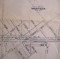
Southern Pacific Lines (San Francisco, Calif).
Right of Way and Track Map of Manteca San Joaquin County California.
San Francisco Calif.: Southern Pacific Company 1934. Map. Blueline print 24" x 56" with red highlighting. Includes Manteca Morrano Calla and vicinity. With L.M. Larson's subdivision Spreckels Sugar Co. Spur. With Schedule of Property listing 17 transfers 1871-1934. Scale 1" = 400'. San Francisco, Calif.: Southern Pacific Company, 1934. unknown
Referentie van de boekhandelaar : 56-0263
|
|
|
Southern Pacific Company
Rules and Regulations for the Government of Employes of the Operating Dept Vol. 2
paperback. Good. Access codes and supplements are not guaranteed with used items. May be an ex-library book. paperback
Referentie van de boekhandelaar : 0282712577.G ISBN : 0282712577 9780282712570
|
|
|
Southern Pacific Company
Rules and Regulations for the Government of Employes of the Operating Dept Vol. 2 Classic Reprint
hardcover. Good. Access codes and supplements are not guaranteed with used items. May be an ex-library book. hardcover
Referentie van de boekhandelaar : 0484472070.G ISBN : 0484472070 9780484472074

|
|
|
Southern Pacific Company
Rules Regarding Accounts Reports and Remittances Classic Reprint
hardcover. Good. Access codes and supplements are not guaranteed with used items. May be an ex-library book. hardcover
Referentie van de boekhandelaar : 0484363670.G ISBN : 0484363670 9780484363679

|
|
 De zoekresultaten per email ontvangen
 Zoekresultaten downloaden als PDF
 RSS feed


