|
|
|
Fausto Codino. a Cura Di
Miti Greci e Romani
16mo, br. ed. pp.320

|
|
|
Fedalto, Giorgio
Ricerche storiche sulla posizione giuridica ed ecclesiastica dei Greci a Venezia nei secoli XV e XVI.
cm. 17 x 24, 176 pp. Fondazione Giorgio Cini - Civilt? veneziana - Saggi 0 gr. 176 p.
|
|
|
Federica Guidi
Morte nell'arena Storia e leggenda dei gladiatori
cartone edit. con titoli al dorso e sovrac. ill., lievi tracce d'umidità alla sovrac., minima macchia al taglio - prima edizione - illustrazioni in b.n. e a colori fuori testo

|
|
|
Feeney Denis.
Letteratura e religione nell'Antica Roma.
8vo, br. ed. 24opp.
|
|
|
FEITH (Everhard), STOEBER (Elias) éditeur, HOMERE (HOMER)
Everhardi Feithii Antiquitatum Homericarum libri IV. Editio Nova prioribus multum emendator, notis et indicibus aucta atque figuris illustrata.
In-12, plein veau havane de l'époque, dos à nerfs orné de caissons fleuronnés et cloisonnés, pièce de titre de maroquin bordeaux, tranches rouges, (10) f, 544 p., 86 p., (37) f. de table et index, titre en rouge et noir avec vignette gravée, 2 planches dépliantes. Nouvelle édition, texte en latin et nombreuses citations en grec, de cette étude très érudite et toujours consultée sur Homère, son œuvre et la Grèce de son temps (organisation sociale, culte, rites, politique, justice, nourriture, musique, jeux, etc.), publiée après la mort précoce de l’auteur par Elias Stoeber, qui signe une préface, ainsi que Jakob Gronovius. Originaire des Pays-Bas, Everhard Feith (1597-ca. 1625) fit ses études en philosophie, philologie et langues anciennes, puis se fixa à La Rochelle, "ville de tête du protestantisme français" où il disparut brutalement, probablement victime d'un assassinat. Deux grandes planches dépliantes, dont une signée "Weis". Petits accrocs aux coins. Très bon exemplaire, bien relié à l'époque.
|
|
|
Fekete, Irene
Athens
[Portraits of Cities series] Nostalgic black ans white photographs of Athens c. 1960. 96p. illus (B & W) maps on end papers.Text neat tight, and complete. with usual library marks, DJ now in protective sleeve Ex-Library
|
|
|
Feliciano Serrao
Classi partiti e legge nella repubblica romana
bross. edit. ill., sottolineature a matita, lieve traccia d'umidità al taglio di testa, leggere fioriture ai tagli, firma d'appartenenza - data di stampa presunta - prima edizione

|
|
|
FENELON.
ANENTURES DE TELEMAQUE.
Paris, 1824, in-8o, 2 vol., 322+400 p., 2 cartes depl.+ 36 planches, rel. 19e plein veau decoree a chaud et a froid, dos a caissons dores, signee Messier.
Riferimento per il libraio : GR415
|
|
|
FENELON.
AVENTURES DE TELEMAQUE.
PARIS, 1830, in-8o, 2 vol., 321+323 p., 25 gravures par Manceau, 1/2 basane contemp.
Riferimento per il libraio : GR027
|
|
|
FENELON
AVENTURES DE TELEMAQUE. Edition collationnée sur les trois manuscrits connus à Paris.
Paris Saintin 1824. 2 volumes petit in-12 2 feuillets non chiffrés 2-340pp, 2 feuillets non chiffrés 3-327pp. Pleine basane blonde, dos lisse orné de filets et larges frises dorées, petite pastilles à froid, plats entièrement frappés à froid d'un décor de filets, large frise et rosace centrale, coupes guillochées, dentelle dorée sur bordure intérieure, tranches dorées, reliure de l'époque. Orné de 8 jolies vignettes hors texte (2 frontispices dont le portrait de Fénelon et 6 illustrations). Travail de vers (1cm) sur 1 mors du Tome II, petit manque de cuir en bordure du 2e plat de ce même tome, pâles rousseurs.
Riferimento per il libraio : GITe122
|
|
|
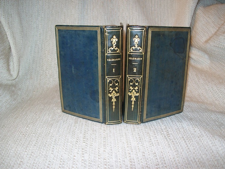
FENELON
AVENTURES DE TELEMAQUE. Edition collationnée sur les trois manuscrits connus à Paris.
Paris De Bure 1823. 2 volumes in-32 2 feuillets non chiffrés XVI 346pp, 2 feuillets non chiffrés 340pp. Plein veau bleu nuit, dos lisse orné en long de filets et fers spéciaux dorés, plats encadrés d'un triple filet doré, coupes filetées, dentelle dorée sur bordure intérieure, tranches dorées, reliure de l'époque. Portrait de Fénelon en frontispice, d'après Daulé et gravé par Pourvoyeur. Quelques rousseurs par endroits. Bel exemplaire, complet de ses volumes, du texte et du frontispice, dans une reliure décorative typique de l'époque, en très bon état.
Riferimento per il libraio : GITe631
|
|
|
FENELON.
Les Aventures d'Aristonous. Préface de Léon Gautier.
Paris, Flammarion, 1920. Petit in-4° broché.
Riferimento per il libraio : 738
|
|
|
Fenaroli, Luigi
Un Frutto D'avvenire Actinidia. Notizie Sul Genere e Sua Coltivazione
Mm 130x195 Collana "Universale". Brossura editoriale di 66 pagine, alcune illustrazioni in bianco e nero e a colori. Rare sottolineature a matita, peraltro buona copia. SPEDIZIONE IN 24 ORE DALLA CONFERMA DELL'ORDINE.
|
|
|
Fenati, Maria Federica
Lucio Flavio Silva Nonio Basso e la Citta di Urbisaglia. [SERIES]: Universita degli Studi di Macerata, Pubblicazioni dell'Istituto di Storia Antica - 1.
Contains color and b&w 16 plates. 245x175 mm. 197 pages. Softcover with dust-jacket. In good condition.
|
|
|
Fenton,Edward
An Island for a Pelican
Original vintage copy of a delightful story for children set on the Greek island of Mykonos and how Vassili rescued Petros the Pelican when he was abducted from the island. Book
|
|
|
Fenton,Edward
The Morning of the Gods
After her mother is killed a young Greek-American girl is sent to stay with relatives in Greece. It is the time of the Junta, and she learn a lot about the village and the kindness of the people and the stresses of living under a dictatorship. Book
|
|
|
Fernand DEVISMES
HISTOIRE des GRANDES CIVILISATIONS
Un ouvrage de 477 pages, format 230 x 185 mm, illustré, relié simili cuir, publié en 1971, Nouvelle Librairie de France (Paris), bon état
Riferimento per il libraio : LFA00a19
|
|
|
Fernand Robert
Homère.
Éditions PUF, 1950, broché, 330 pages.
Riferimento per il libraio : AIX-1837

|
|
|
FERRARIO Giulio.
IL COSTUME ANTICO E MODERNO o Storia del Governo, della Milizia, della Religione, delle Arti, Scienze ed usanze di tutti i popoli antichi e moderni proposta coi monumenti dell'antichità e rappresentata cogli analoghi disegni. Europa, vol. I.
Firenze, V. Bartelli, 1826. In-8o, 3 fasciscules brochees de p. 97 a p. 344 avec 43 planches hors-texte. Dos faible au 2e fasc.
Riferimento per il libraio : HI023
|
|
|
Fernand BRAUDEL
LES MEMOIRES de la MEDITERRANEE : PREHISTOIRE et ANTIQUITE
Un ouvrage de 400 pages, format 155 x 230 mm, illustré, broché couverture couleurs, publié en 1998, bon état
Riferimento per il libraio : LFA-126735863
|
|
|
Fernand COMTE
Les GRANDES FIGURES des MYTHOLOGIES
Un ouvrage de 256 pages, format 130 x 195 mm, illustré, relié cartonnage couleurs, publié en 1988, bon état
Riferimento per il libraio : LFA-126743006
|
|
|
FERRER Giuseppe di
Mémoires d'un ancien capitaine italien sur les guerres et les intrigues d'Italie de 1806 à 1821. Par M. le Comte G.D.F., traduit de l'Italien par l'auteur lui-même
Paris Chez l'auteur [Valence, Impr. de J. Marc Aurel] 1845 in-8 demi-bas. verte, dos lisse orné, filets et fleurons dorés, tr. mouch. [Rel. de l'époque], qq. piqûres
Riferimento per il libraio : 4548
|
|
|
FERDINANDO GREGOROVIUS: TEOFILO GAUTIER
le meraviglie della civiltà del passato vol.II
Raccolta di testi sulle civiltà del passato con 500 illustrazioni e 20 tavole a colori fuori testo. Volume secondo.
|
|
|
Ferguson
Fra gli dei dell'Olimpo. Un'indagine archeologica sulla religione della Grecia Antica
8vo. br. ed. Un'indagine archeologica sulla religione della Grecia antica. Traduzione di Martino Menghi Biblioteca Universale Laterza pp. XVI + 268
|
|
|
Ferguson, Ronald Muir; Halliburton, Richard; O'Brien, R.Barry; Ryall, Monica; Musson, H.P.; Bushby, Geoffrey H.; Green, Lawrence G.; Madison, Tony; Pearson, T.; Frankl, A.; Webb, Harry E.; Maule, D.; Fitzpatrick, Capt. J.F.J.; Pardees, Major John;
The Wide World Magazine - True Stories of Adventure, February 1927 - Trapped in the Volcano of Kilauea
Features: The Singing Tree - a story from the Bushveld of South Africa; The Road to Romanc - Part I of the amazing round-the-world travels of Cyril Holloway; Photo of ice-fishing in Vladivostock Harbour; Timber-Laden Round Cape Horn - a windjamming tale; An Aeroplane Adventure in Waziristan - the story of a British officer who was captured by the Wazirs; A Tenderfoot in Canada, Part II - a disastrous season on a prairie farm; Trapped in the Volcano of Kilauea, in the Hawaiian Islands; The Hundredth Chance - a story from the Union-Castle cargo-steamer Ripley Castle; What Happened to Ah Fong? - an unsolved Chinese mystery; Monasteries in Mid-Air - the remarkable monasteries of Meteora, in Greece - article with excellent photos; A Mystery of the "Bad Lands" - a cowboy story from Wyoming; The Rogue - a rogue elephant in central Africa; Bakhai, the Rebel of Babban Kurmi; The Mountain of Gold - conclusion of the author's journey to Canada; Nice vintage ads, including photo of Earle E. Liederman, the Muscle Builder. Multiple pieces of red, clear and brown tape securing covers. Somewhat above-average wear. A worthy vintage copy. Book

|
|
|
Ferla, Kleopatra (ed.)
Priene
Book is in excellent condition in deep blue cloth HB covers with silver print at cover and spine. decorated endpapers with two -page b&w photo spread of the site. Binding is solid and square, covers have sharp corners, exterior shows no blemishes, text/interior is clean and free of marking of any kind. Faint mark to cover and small coffee dot stain to lower front endpaper are only flaws, otherwise as new. Dust jacket shows light edge wear, 1" open tear top edge back cover. Very detailed study of the excavation of the site of the city of Priene, Greece full of measured drawings, maps, cross sections, elevations, architectural detail in measured drawings, floor plans, color and b&w photos, artist's renderings, contour drawings of the various temples, sanctuaries, theaters, the stadium, houses, Christian structures, with appendicies for the ionic order and doric order columns, roof structures and detail (including lesbian cyma). All glossy paper, oblong format, 231 pages. Copyright 2011 Pistil Books

|
|
|
FERMOR Patrick Leigh
Roumeli. Travels in Northern Greece. [With Photographs by Joan Eyres Monsell]. NEAR FINE COPY IN UNCLIPPED DUSTWRAPPER
8vo., First Edition, with 20 plates and double-page map on grey stock; blue cloth, upper board blocked in gilt, gilt back, some light offsetting from wrapper to backstrip else a near fine copy in unclipped dustwrapper. Wonderful dustwrapper artwork by John Craxton (who also designed the map). VERY SCARCE IN THIS CONDITION.

|
|
|
Fermor, Patrick Leigh
Mani : Travels in the Southern Peloponnese
London: John Murray 1958 Book. Illus. by John Craxton / Joan Eyres Monsell. Fine. Hardcover. 1st UK Edition. 'The Mani is the remotest the wildest and the most isolated region of Greece. Cut off from the rest of the country by the towering range of the Taygetus and hemmed in by the Aegean and Ionian seas this rocky central prong of the Peloponnese is the southernmost point of Mediterranean Europe. . . This book is the beginning of a wider enterprise: the exploration of the Greek world and its long history through a series of penetrations in depth at various unexpected points. Photographs by Joan Eyres Monsell Frontispiece by John Craxton.Map by John Woodcock 320p. Illus.map.index. Crisp almost as new except for slight darkening of spine. John Murray hardcover
Riferimento per il libraio : 047142
|
|
|
Fermor, Patrick Leigh
Mani : Travels in the Southern Peloponnese
London: John Murray 1958 Book. Illus. by John Craxton / Joan Eyres Monsell. Fine. Hardcover. 1st UK Edition. 'The Mani is the remotest the wildest and the most isolated region of Greece. Cut off from the rest of the country by the towering range of the Taygetus and hemmed in by the Aegean and Ionian seas this rocky central prong of the Peloponnese is the southernmost point of Mediterranean Europe. . . This book is the beginning of a wider enterprise: the exploration of the Greek world and its long history through a series of penetrations in depth at various unexpected points. Photographs by Joan Eyres Monsell Frontispiece by John Craxton 320p. Illus.map.index. Neat tight copy.Name of previous owner Prof M.E.B.Wallace University of Toronto on ffep else fine. John Murray hardcover
Riferimento per il libraio : 047140
|
|
|
Fermor, Patrick Leigh
The Broken Road: From the Iron Gates to Mount Athos
In the winter of 1933 eighteen-year-old Patrick Leigh Fermor set out to walk across Europe, starting in Holland and ending in Constantinople, a trip that took him the better part of a year. Decades later, when he was well over fifty, Leigh Fermor told the story of that life-changing journey in A Time of Gifts and Between the Woods and the Water, two works now celebrated as among the most vivid, absorbing, delightful, and beautifully-written travel books of all time.The Broken Road is the long and avidly awaited account of the final leg of his youthful adventure that Leigh Fermor promised but was unable to finish before his death in 2011. Assembled from Leigh Fermor's manuscripts by his prize-winning biographer Artemis Cooper and the travel writer Colin Thubron, this is perhaps the most personal of all Leigh Fermor's books, catching up with young Paddy in the fall of 1934 and following him through Bulgaria and Romania to the coast of the Black Sea. Days and nights on the road, spectacular landscapes and uncanny cities, friendships lost and found, leading the high life in Bucharest or camping out with fishermen and shepherds: in the The Broken Road such incidents and escapades are described with all the linguistic bravura, odd and astonishing learning, and overflowing exuberance that Leigh Fermor is famous for, but also with a melancholy awareness of the passage of time, especially when he meditates on the scarred history of the Balkans or on his troubled relations with his father. The book ends, perfectly, with Paddy's diary from the winter of 1934, when he had reached Greece, the country he would fall in love with and fight for. Across the space of three quarters of century we can still hear the ringing voice of an irrepressible young man embarking on a life of adventure. 384p. Paper age toned. else as new Book
|
|
|
Fermor, Patrick Leigh
Words of Mercury
"Patrick Leigh Fermor was only 18 when he set off to walk from the Hook of Holland to Constantinople ...it was during these early wanderings that he started to pick up languages wherever he went an to develop his extraordinary sense of the continuity of history : a quality that deepens and colours of every place that he writes about , from the parks of the Pyrenees to the cell fo a Trappist Monastery... Its infectious enthusiasm is driven by an insatiable curiosity and an omnivorous mind - all inspired by a passion for words and language that makes hom one of the greatest prose writers of his generation" A wonderful anthology of extracts from his books, book reviews and essays .274p. Book
|
|
|
Fermor, Patrick Leigh & Cooper, Artemis
Patrick Leigh Fermor : An Adventure
Patrick Leigh Fermor (1915-2011) was a war hero whose exploits in Crete are legendary, and above all he is widely acclaimed as the greatest travel writer of our times, notably for his books about his walk across pre-war Europe, A Time of Gifts and Between the Woods and the Water; he was a self-educated polymath, a lover of Greece and the best company in the world. Artemis Cooper has drawn on years of interviews and conversations with Paddy and his closest friends as well as having complete access to his archives. Her beautifully crafted biography portrays a man of extraordinary gifts - no one wore their learning so playfully, nor inspired such passionate friendship. 448 pp. Book
|
|
|
Fermor,Patrick Leigh
Roumeli : Travels in Northern Greece.
London: John Murray 1966 Book. Fine. Hardcover. 1st UK Edition. "South of Macedonia somewhat overlapping ancient Thrace lies the wild isolated region known long ago as Roumeli" Here among people as fiercely independent as those of the Mani peninsula the remarkable Patrick Fermor lived the life of the people joining the wedding guests journeying to the cloud-high monasteries learning the tricks of the professional beggars. Recalling this remote and ardent world Mr. Fermor explores the very heart of the Greek temperament.with the unfailing gaiety sympathy and curiosity which make him one of the best travel writers of our timV 248p. plates map.Index . John Murray hardcover
Riferimento per il libraio : 047144
|
|
|
Fermor,Patrick Leigh
Roumeli : Travels in Northern Greece.
"South of Macedonia, somewhat overlapping ancient Thrace, lies the wild, isolated region known long ago as Roumeli. Here, among people as fiercely independent as those of the Mani peninsula, the remarkable Patrick Fermor lived the life of the people, joining the wedding guests, journeying to the cloud-high monasteries, learning the tricks of the professional beggars. Recalling this remote and ardent world, Mr. Fermor explores the very heart of the Greek temperament.with the unfailing gaiety, sympathy, and curiosity which make him one of the best travel writers of our time." 248p.map.Index. Paper slightly age toned, remainder mark, else fine Book
|
|
|
Fernandez, Dominique
Viaggio in Sicilia
Mm 265x310 Volume cartonato rigido, sopracoperta illustrata, 240 pagine con numerose illustrazioni a colori nel testo. Fotografie di Ferrante Ferranti. Stupendo libro del grande italianista francese sulla Sicilia e i siciliani qui offerto in perfette condizioni di nuovo. Spedizione in 24 ore dalla conferma dell'ordine.
|
|
|
FERNAU, Joachim
Rosen fur Apoll. Die Geschichte der Griechen
1 Vol. In-16 t. editoriale.Risg. e sovracpt. ill pag. 311 PROG 6157 CATT_ATT 14
|
|
|
FERNÁNDEZ CLEMENTE, Eloy.
Ulises en el Siglo XX. Crisis y modernización en Grecia, 1900 - 1930.
Zaragoza, Prensas Universitarias, 1995. 4to.; 295 pp. Cubiertas originales.

|
|
|
FERNÁNDEZ GONZÁLEZ, Vicente.
La Ciudad de las Ideas. Sobre la poesía de C.P. Cavafis y sus traducciones castellanas.
Madrid-Málaga, 2001 ["Nueva Roma"]. 4to. mayor; XXV pp., 460 pp. Cubiertas originales.

|
|
|
Ferrabino, Aldo
Il problema dell'unità nazionale nella Grecia antica: I. Arato di Sicione e l'idea Nazionale
Mm 170x240 Collana "Studia Historica", 105. Ristampa anastatica dell'edizione Firenze 1921 - Volume rilegato in pelle con titolo oro su etichetta applicata al dorso, 307 pagine. Opera in ottime condizioni. SPEDIZIONE IN 24 ORE DALLA CONFERMA DELL'ORDINE.
|
|
|
Ferrandini Troisi Franca (a cura)
Iscrizioni greche d'Italia. Puglia.
<p>27 cm, brossura editoriale, p. 159. Numerose foto in nero n.t.</p>

|
|
|
Ferrara, Mario
Per l'Iconografia della Vita e delle Opere di Giovanni Pascoli. Il Pascoli a Massa
Mm 155x240 Brossura originale con copertina a stampa, 10 pagine. Buona copia. Spedizione in 24 ore dalla conferma dell'ordine.
|
|
|
FERRARIO Giulio
Il costume antico e moderno ovvero storia del governo, della milizia, della religione, delle arti, scienze ed usanze di tutti i popoli antichi e moderni provata coi monumenti dell'antichita' e rappresentata con analoghi disegni. Terza edizione. Europa. Volume primo (-terzo)
3 voll. in 8, pp. 441 + (1b) + (2) con 11 tavv. f.t. inc. all'acq. acquerellate a colori, 2 tavv. sinott. f.t. piu' volte rip., tavv. sinott. n.t.; 580 + (2) con 19 tavv. f.t.; 448 + (4) con 14 tavv. f.t. Fioriture alle cc. Legatura in mz. pl. coeva con tasselli al d. Tre volumi della ponderosa opera di Ferrario sui continenti con notizie geografiche, storiche e di carattere etno-antropologico. I tre volumi sono dedicati alla Grecia.
|
|
|
Ferrario, Carlo Antonio
Vicende e Problemi della Penisola Balcanica 1815-1937
Mm 120x175 Volume in copertina rigida originale, 318 pagine con 5 mappe più volte ripiegate in chiusura. Un ex libris ed un piccolo timbro di biblioteca privata dismessa in apertura, peraltro la copia è in ottime condizioni. Spedizione in 24 ore dalla conferma dell'ordine.
|
|
|
FERRERO GUGLIELMO
LE DONNE DEI CESARI
In-16, pp. VII-164, rilegato in tutta tela, titoli oro, ill.fotografiche f.t.
|
|
|
FERRETTI Francesco (1523 - 1593)
Ragionevole Forma et Vera Postura del' Isola di Andria
Elegante piccola carta geografica dell'isola tratta dai Dialoghi Notturni del Capitano Francesco Ferretti Cavaglier di S. Stefano, edito ad Ancona da Giovan Battista Ciotti, nel 1604. Si tratta della seconda edizione del celebre “isolario” di Francesco Ferretti (per la prima volta edito nel 1579), che contiene 28 mappe di isole europee incise in rame, e racchiuse dentro una cornice ornamentale di forma rotonda, che conferisce alle carte un’inusuale e particolarissima forma alla mappa. Questo raro trattato che fornisce nozioni scientifiche e militari, oltre che geografiche e matematiche. La parte geografica costituisce il corpus principale dell’opera, con le 28 mappe raffiguranti le principali isole del Mediterraneo rappresentate con l’inusuale forma circolare, finemente intagliate da Michelangelo Marelli. Le carte derivano da quelle intagliate da Girolamo Porro per L’isole Piu Famose Del Mondo Descritte Da Thomaso Porcacchi Da Castiglione, edito per la prima volta nel 1572. Ogni carta è racchiusa entro una cornice ornamentale, e mostra le linee dei venti. Il titolo, racchiuso nella parte superiore, è molto grande ed è espresso con la formula Ragionevol’ Forma et vera postura del’ Isola di, seguito dal nome dell’isola. Le mappe sono di piccole dimensioni ma molto accurate. L’opera del Ferretti venne ristampata nel 1608 con il titolo di Arte Militare. Acquaforte e bulino, rifilata la rame o con piccoli margini, in ottimo stato di conservazione. Bibliografia Mortimer 184; Olschki 4539; Cockle 548; Shirley T.FRR-1a. - Nordenskiold Collection I, p.156 no.73; Dufour/La Gumina, p. 85; Ganado 1985 S. 231; Stylianou 81, Navari 33; Zacharakis/Scutari 1499/1003-1518/1022; King, Miniature Antique Maps, pp. 62/3. Nice miniature map of the island, taken from Dialoghi Notturni del Capitano Francesco Ferretti Cavaglier di S. Stefano published in Ancona in 1604. It's the second edition of the rare “Isolario” by Ferretti, that provides scientific knowledge and military, as well as geography and mathematics. The geographical part is the main body of the work, with 28 maps depicting the main islands in the Mediterranean represented with the unusual circular shape, finely carved by Michelangelo Marelli. The maps derive from those engraved by Girolamo Porro for the L’isole Piu Famose Del Mondo Descritte Da Thomaso Porcacchi Da Castiglione, published for the first time in 1572. Each map is enclosed within an ornamental frame, and shows the lines of the winds. The title, enclosed at the top, is very large and is expressed by the formula Ragionevol’ Forma et vera postura del’ Isola di, followed by the name of the island; the maps are small but very accurate. The work of Ferretti was reprinted in 1608 with the title Arte Militare. Literature Mortimer 184; Olschki 4539; Cockle 548; Shirley T.FRR-1a. - Nordenskiold Collection I, p.156 no.73; Dufour/La Gumina, p. 85; Ganado 1985 S. 231; Stylianou 81, Navari 33; Zacharakis/Scutari 1499/1003-1518/1022; King, Miniature Antique Maps, pp. 62/3. G. Tolias, Mapping Greece, 0727; Zacharakis, A Catalogue of Printed Maps of Greece 1477-1800, 1509.

|
|
|
FERRETTI Francesco (1523 - 1593)
Ragionevole Forma et Vera Postura del' Isola di Calamo
Elegante piccola carta geografica dell'isola tratta dai Dialoghi Notturni del Capitano Francesco Ferretti Cavaglier di S. Stefano, edito ad Ancona da Giovan Battista Ciotti, nel 1604. Si tratta della seconda edizione del celebre “isolario” di Francesco Ferretti (per la prima volta edito nel 1579), che contiene 28 mappe di isole europee incise in rame, e racchiuse dentro una cornice ornamentale di forma rotonda, che conferisce alle carte un’inusuale e particolarissima forma alla mappa. Questo raro trattato che fornisce nozioni scientifiche e militari, oltre che geografiche e matematiche. La parte geografica costituisce il corpus principale dell’opera, con le 28 mappe raffiguranti le principali isole del Mediterraneo rappresentate con l’inusuale forma circolare, finemente intagliate da Michelangelo Marelli. Le carte derivano da quelle intagliate da Girolamo Porro per L’isole Piu Famose Del Mondo Descritte Da Thomaso Porcacchi Da Castiglione, edito per la prima volta nel 1572. Ogni carta è racchiusa entro una cornice ornamentale, e mostra le linee dei venti. Il titolo, racchiuso nella parte superiore, è molto grande ed è espresso con la formula Ragionevol’ Forma et vera postura del’ Isola di, seguito dal nome dell’isola. Le mappe sono di piccole dimensioni ma molto accurate. L’opera del Ferretti venne ristampata nel 1608 con il titolo di Arte Militare. Acquaforte e bulino, rifilata la rame o con piccoli margini, in ottimo stato di conservazione. Bibliografia Mortimer 184; Olschki 4539; Cockle 548; Shirley T.FRR-1a. - Nordenskiold Collection I, p.156 no.73; Dufour/La Gumina, p. 85; Ganado 1985 S. 231; Stylianou 81, Navari 33; Zacharakis/Scutari 1499/1003-1518/1022; King, Miniature Antique Maps, pp. 62/3. Nice miniature map of the island, taken from Dialoghi Notturni del Capitano Francesco Ferretti Cavaglier di S. Stefano published in Ancona in 1604. It's the second edition of the rare “Isolario” by Ferretti, that provides scientific knowledge and military, as well as geography and mathematics. The geographical part is the main body of the work, with 28 maps depicting the main islands in the Mediterranean represented with the unusual circular shape, finely carved by Michelangelo Marelli. The maps derive from those engraved by Girolamo Porro for the L’isole Piu Famose Del Mondo Descritte Da Thomaso Porcacchi Da Castiglione, published for the first time in 1572. Each map is enclosed within an ornamental frame, and shows the lines of the winds. The title, enclosed at the top, is very large and is expressed by the formula Ragionevol’ Forma et vera postura del’ Isola di, followed by the name of the island; the maps are small but very accurate. The work of Ferretti was reprinted in 1608 with the title Arte Militare. Literature Mortimer 184; Olschki 4539; Cockle 548; Shirley T.FRR-1a. - Nordenskiold Collection I, p.156 no.73; Dufour/La Gumina, p. 85; Ganado 1985 S. 231; Stylianou 81, Navari 33; Zacharakis/Scutari 1499/1003-1518/1022; King, Miniature Antique Maps, pp. 62/3. G. Tolias, Mapping Greece, 0722; Zacharakis, A Catalogue of Printed Maps of Greece 1477-1800, 1504.

|
|
|
FERRETTI Francesco (1523 - 1593)
Ragionevole Forma et Vera Postura del' Isola di Calogero
Elegante piccola carta geografica dell'isola tratta dai Dialoghi Notturni del Capitano Francesco Ferretti Cavaglier di S. Stefano, edito ad Ancona da Giovan Battista Ciotti, nel 1604. Si tratta della seconda edizione del celebre “isolario” di Francesco Ferretti (per la prima volta edito nel 1579), che contiene 28 mappe di isole europee incise in rame, e racchiuse dentro una cornice ornamentale di forma rotonda, che conferisce alle carte un’inusuale e particolarissima forma alla mappa. Questo raro trattato che fornisce nozioni scientifiche e militari, oltre che geografiche e matematiche. La parte geografica costituisce il corpus principale dell’opera, con le 28 mappe raffiguranti le principali isole del Mediterraneo rappresentate con l’inusuale forma circolare, finemente intagliate da Michelangelo Marelli. Le carte derivano da quelle intagliate da Girolamo Porro per L’isole Piu Famose Del Mondo Descritte Da Thomaso Porcacchi Da Castiglione, edito per la prima volta nel 1572. Ogni carta è racchiusa entro una cornice ornamentale, e mostra le linee dei venti. Il titolo, racchiuso nella parte superiore, è molto grande ed è espresso con la formula Ragionevol’ Forma et vera postura del’ Isola di, seguito dal nome dell’isola. Le mappe sono di piccole dimensioni ma molto accurate. L’opera del Ferretti venne ristampata nel 1608 con il titolo di Arte Militare. Acquaforte e bulino, rifilata la rame o con piccoli margini, in ottimo stato di conservazione. Bibliografia Mortimer 184; Olschki 4539; Cockle 548; Shirley T.FRR-1a. - Nordenskiold Collection I, p.156 no.73; Dufour/La Gumina, p. 85; Ganado 1985 S. 231; Stylianou 81, Navari 33; Zacharakis/Scutari 1499/1003-1518/1022; King, Miniature Antique Maps, pp. 62/3. Nice miniature map of the island, taken from Dialoghi Notturni del Capitano Francesco Ferretti Cavaglier di S. Stefano published in Ancona in 1604. It's the second edition of the rare “Isolario” by Ferretti, that provides scientific knowledge and military, as well as geography and mathematics. The geographical part is the main body of the work, with 28 maps depicting the main islands in the Mediterranean represented with the unusual circular shape, finely carved by Michelangelo Marelli. The maps derive from those engraved by Girolamo Porro for the L’isole Piu Famose Del Mondo Descritte Da Thomaso Porcacchi Da Castiglione, published for the first time in 1572. Each map is enclosed within an ornamental frame, and shows the lines of the winds. The title, enclosed at the top, is very large and is expressed by the formula Ragionevol’ Forma et vera postura del’ Isola di, followed by the name of the island; the maps are small but very accurate. The work of Ferretti was reprinted in 1608 with the title Arte Militare. Literature Mortimer 184; Olschki 4539; Cockle 548; Shirley T.FRR-1a. - Nordenskiold Collection I, p.156 no.73; Dufour/La Gumina, p. 85; Ganado 1985 S. 231; Stylianou 81, Navari 33; Zacharakis/Scutari 1499/1003-1518/1022; King, Miniature Antique Maps, pp. 62/3. G. Tolias, Mapping Greece, 0723; Zacharakis, A Catalogue of Printed Maps of Greece 1477-1800, 1505.

|
|
|
FERRETTI Francesco (1523 - 1593)
Ragionevole Forma et Vera Postura del' Isola di Cerigo
Elegante piccola carta geografica dell'isola tratta dai Dialoghi Notturni del Capitano Francesco Ferretti Cavaglier di S. Stefano, edito ad Ancona da Giovan Battista Ciotti, nel 1604. Si tratta della seconda edizione del celebre “isolario” di Francesco Ferretti (per la prima volta edito nel 1579), che contiene 28 mappe di isole europee incise in rame, e racchiuse dentro una cornice ornamentale di forma rotonda, che conferisce alle carte un’inusuale e particolarissima forma alla mappa. Questo raro trattato che fornisce nozioni scientifiche e militari, oltre che geografiche e matematiche. La parte geografica costituisce il corpus principale dell’opera, con le 28 mappe raffiguranti le principali isole del Mediterraneo rappresentate con l’inusuale forma circolare, finemente intagliate da Michelangelo Marelli. Le carte derivano da quelle intagliate da Girolamo Porro per L’isole Piu Famose Del Mondo Descritte Da Thomaso Porcacchi Da Castiglione, edito per la prima volta nel 1572. Ogni carta è racchiusa entro una cornice ornamentale, e mostra le linee dei venti. Il titolo, racchiuso nella parte superiore, è molto grande ed è espresso con la formula Ragionevol’ Forma et vera postura del’ Isola di, seguito dal nome dell’isola. Le mappe sono di piccole dimensioni ma molto accurate. L’opera del Ferretti venne ristampata nel 1608 con il titolo di Arte Militare. Acquaforte e bulino, rifilata la rame o con piccoli margini, in ottimo stato di conservazione. Bibliografia Mortimer 184; Olschki 4539; Cockle 548; Shirley T.FRR-1a. - Nordenskiold Collection I, p.156 no.73; Dufour/La Gumina, p. 85; Ganado 1985 S. 231; Stylianou 81, Navari 33; Zacharakis/Scutari 1499/1003-1518/1022; King, Miniature Antique Maps, pp. 62/3. Nice miniature map of the island, taken from Dialoghi Notturni del Capitano Francesco Ferretti Cavaglier di S. Stefano published in Ancona in 1604. It's the second edition of the rare “Isolario” by Ferretti, that provides scientific knowledge and military, as well as geography and mathematics. The geographical part is the main body of the work, with 28 maps depicting the main islands in the Mediterranean represented with the unusual circular shape, finely carved by Michelangelo Marelli. The maps derive from those engraved by Girolamo Porro for the L’isole Piu Famose Del Mondo Descritte Da Thomaso Porcacchi Da Castiglione, published for the first time in 1572. Each map is enclosed within an ornamental frame, and shows the lines of the winds. The title, enclosed at the top, is very large and is expressed by the formula Ragionevol’ Forma et vera postura del’ Isola di, followed by the name of the island; the maps are small but very accurate. The work of Ferretti was reprinted in 1608 with the title Arte Militare. Literature Mortimer 184; Olschki 4539; Cockle 548; Shirley T.FRR-1a. - Nordenskiold Collection I, p.156 no.73; Dufour/La Gumina, p. 85; Ganado 1985 S. 231; Stylianou 81, Navari 33; Zacharakis/Scutari 1499/1003-1518/1022; King, Miniature Antique Maps, pp. 62/3. G. Tolias, Mapping Greece, 0719; Zacharakis, A Catalogue of Printed Maps of Greece 1477-1800, 1501.

|
|
|
FERRETTI Francesco (1523 - 1593)
Ragionevole Forma et Vera Postura del' Isola di Dromo et Serachino
Elegante piccola carta geografica dell'isola tratta dai Dialoghi Notturni del Capitano Francesco Ferretti Cavaglier di S. Stefano, edito ad Ancona da Giovan Battista Ciotti, nel 1604. Si tratta della seconda edizione del celebre “isolario” di Francesco Ferretti (per la prima volta edito nel 1579), che contiene 28 mappe di isole europee incise in rame, e racchiuse dentro una cornice ornamentale di forma rotonda, che conferisce alle carte un’inusuale e particolarissima forma alla mappa. Questo raro trattato che fornisce nozioni scientifiche e militari, oltre che geografiche e matematiche. La parte geografica costituisce il corpus principale dell’opera, con le 28 mappe raffiguranti le principali isole del Mediterraneo rappresentate con l’inusuale forma circolare, finemente intagliate da Michelangelo Marelli. Le carte derivano da quelle intagliate da Girolamo Porro per L’isole Piu Famose Del Mondo Descritte Da Thomaso Porcacchi Da Castiglione, edito per la prima volta nel 1572. Ogni carta è racchiusa entro una cornice ornamentale, e mostra le linee dei venti. Il titolo, racchiuso nella parte superiore, è molto grande ed è espresso con la formula Ragionevol’ Forma et vera postura del’ Isola di, seguito dal nome dell’isola. Le mappe sono di piccole dimensioni ma molto accurate. L’opera del Ferretti venne ristampata nel 1608 con il titolo di Arte Militare. Acquaforte e bulino, rifilata la rame o con piccoli margini, in ottimo stato di conservazione. Bibliografia Mortimer 184; Olschki 4539; Cockle 548; Shirley T.FRR-1a. - Nordenskiold Collection I, p.156 no.73; Dufour/La Gumina, p. 85; Ganado 1985 S. 231; Stylianou 81, Navari 33; Zacharakis/Scutari 1499/1003-1518/1022; King, Miniature Antique Maps, pp. 62/3. Nice miniature map of the island, taken from Dialoghi Notturni del Capitano Francesco Ferretti Cavaglier di S. Stefano published in Ancona in 1604. It's the second edition of the rare “Isolario” by Ferretti, that provides scientific knowledge and military, as well as geography and mathematics. The geographical part is the main body of the work, with 28 maps depicting the main islands in the Mediterranean represented with the unusual circular shape, finely carved by Michelangelo Marelli. The maps derive from those engraved by Girolamo Porro for the L’isole Piu Famose Del Mondo Descritte Da Thomaso Porcacchi Da Castiglione, published for the first time in 1572. Each map is enclosed within an ornamental frame, and shows the lines of the winds. The title, enclosed at the top, is very large and is expressed by the formula Ragionevol’ Forma et vera postura del’ Isola di, followed by the name of the island; the maps are small but very accurate. The work of Ferretti was reprinted in 1608 with the title Arte Militare. Literature Mortimer 184; Olschki 4539; Cockle 548; Shirley T.FRR-1a. - Nordenskiold Collection I, p.156 no.73; Dufour/La Gumina, p. 85; Ganado 1985 S. 231; Stylianou 81, Navari 33; Zacharakis/Scutari 1499/1003-1518/1022; King, Miniature Antique Maps, pp. 62/3. G. Tolias, Mapping Greece, 0733; Zacharakis, A Catalogue of Printed Maps of Greece 1477-1800, 1515.

|
|
|
FERRETTI Francesco (1523 - 1593)
Ragionevole Forma et Vera Postura del' Isola di Lango
Elegante piccola carta geografica dell'isola tratta dai Dialoghi Notturni del Capitano Francesco Ferretti Cavaglier di S. Stefano, edito ad Ancona da Giovan Battista Ciotti, nel 1604. Si tratta della seconda edizione del celebre “isolario” di Francesco Ferretti (per la prima volta edito nel 1579), che contiene 28 mappe di isole europee incise in rame, e racchiuse dentro una cornice ornamentale di forma rotonda, che conferisce alle carte un’inusuale e particolarissima forma alla mappa. Questo raro trattato che fornisce nozioni scientifiche e militari, oltre che geografiche e matematiche. La parte geografica costituisce il corpus principale dell’opera, con le 28 mappe raffiguranti le principali isole del Mediterraneo rappresentate con l’inusuale forma circolare, finemente intagliate da Michelangelo Marelli. Le carte derivano da quelle intagliate da Girolamo Porro per L’isole Piu Famose Del Mondo Descritte Da Thomaso Porcacchi Da Castiglione, edito per la prima volta nel 1572. Ogni carta è racchiusa entro una cornice ornamentale, e mostra le linee dei venti. Il titolo, racchiuso nella parte superiore, è molto grande ed è espresso con la formula Ragionevol’ Forma et vera postura del’ Isola di, seguito dal nome dell’isola. Le mappe sono di piccole dimensioni ma molto accurate. L’opera del Ferretti venne ristampata nel 1608 con il titolo di Arte Militare. Acquaforte e bulino, rifilata la rame o con piccoli margini, in ottimo stato di conservazione. Bibliografia Mortimer 184; Olschki 4539; Cockle 548; Shirley T.FRR-1a. - Nordenskiold Collection I, p.156 no.73; Dufour/La Gumina, p. 85; Ganado 1985 S. 231; Stylianou 81, Navari 33; Zacharakis/Scutari 1499/1003-1518/1022; King, Miniature Antique Maps, pp. 62/3. Nice miniature map of the island, taken from Dialoghi Notturni del Capitano Francesco Ferretti Cavaglier di S. Stefano published in Ancona in 1604. It's the second edition of the rare “Isolario” by Ferretti, that provides scientific knowledge and military, as well as geography and mathematics. The geographical part is the main body of the work, with 28 maps depicting the main islands in the Mediterranean represented with the unusual circular shape, finely carved by Michelangelo Marelli. The maps derive from those engraved by Girolamo Porro for the L’isole Piu Famose Del Mondo Descritte Da Thomaso Porcacchi Da Castiglione, published for the first time in 1572. Each map is enclosed within an ornamental frame, and shows the lines of the winds. The title, enclosed at the top, is very large and is expressed by the formula Ragionevol’ Forma et vera postura del’ Isola di, followed by the name of the island; the maps are small but very accurate. The work of Ferretti was reprinted in 1608 with the title Arte Militare. Literature Mortimer 184; Olschki 4539; Cockle 548; Shirley T.FRR-1a. - Nordenskiold Collection I, p.156 no.73; Dufour/La Gumina, p. 85; Ganado 1985 S. 231; Stylianou 81, Navari 33; Zacharakis/Scutari 1499/1003-1518/1022; King, Miniature Antique Maps, pp. 62/3. G. Tolias, Mapping Greece, 0726; Zacharakis, A Catalogue of Printed Maps of Greece 1477-1800, 1508.

|
|
|

 Ricevere i risultati per e-mail
 Scaricare i risultati in PDF
 RSS feed
 Link
Link


