|
Les monuments historiques de Roumanie.
Bucarest, imp. Lucefarul, 1937, 1 br., couverture illustrée par P. Grant, cartes sur les gardes. in-8 carré de 24 pp., illustrations ;
Référence libraire : 5063
|
|
|
Les ennemis de la paix et de la liberte des peuples. La politique agressive et les machinations de l'impérialisme américain contre la République Populaire Roumaine.
in-8° gr., pp. 158-(1). Leg. in cartonato edit. con tit. al piatto ant.; tracce del tempo e d'uso sui piatti, buono l'interno. Timbri annullati di biblioteca all'interno. Etichetta della stessa sul contropiatto ant.
|
|
|
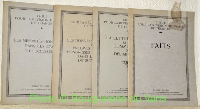
Ligue pour la révision du Traité de Trianon. 4 Fascicules.I: Les minorités hongroises dans leurs états dit successeurs.II: Les données statistiques des enclaves homogènes hongroises et allemandes dans leurs états dit successeurs.III: La lettre d’envoi et les commissions de délimitation.VII: Faits.
Budapest, Victor Hornyansky 1928, 255x185mm, broché.
Référence libraire : 58672
|
|
|
LOTTA (LA) secolare del popolo romeno per l'indipendenza, la libertà e l'unità nazionale. Documenti. VII.
Roma, 1982, in-8, tela editoriale, con sovraccoperta.

|
|
|
Lugos - Land: Ungarn (= General-Karte von Mittel-Europa 1:200 000. 175. 40? 46?)
Wien, Kaiserlich-K?nigliches Milit?r-Geographisches Institut, 1914. Hochformat, ca. 38 x 55 cm, Ausgabe: mehrf?rbig; Zustand: gut +
Référence libraire : A111-118

|
|
|
Lugos - Land: Ungarn (= General-Karte von Mittel-Europa 1:200 000. 175. 40? 46?)
Wien, Kaiserlich-K?nigliches Milit?r-Geographisches Institut, 1895. Hochformat, ca. 38 x 55 cm, gefaltet zu 8 Segmenten, Ausgabe: mehrf?rbig; Zustand: blasser Druck, sonst gut +
Référence libraire : A141-1290

|
|
|
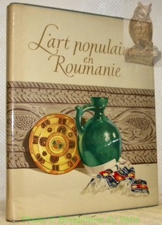
L’art populaire en Roumanie. Textes rédigés par le collectif scientifique du Musée d’Art populaire de la R.P.R.. Couverture: Oswald Adler. Illustrations: Dem Demetresco.
Bucarest, Editions de l’Institut Roumain pour les Relations Culturelles avec l’Etranger 1955, 310x245mm, reliure d'éditeur sous jaquette. Bel exemplaire.
Référence libraire : 30735
|
|
|
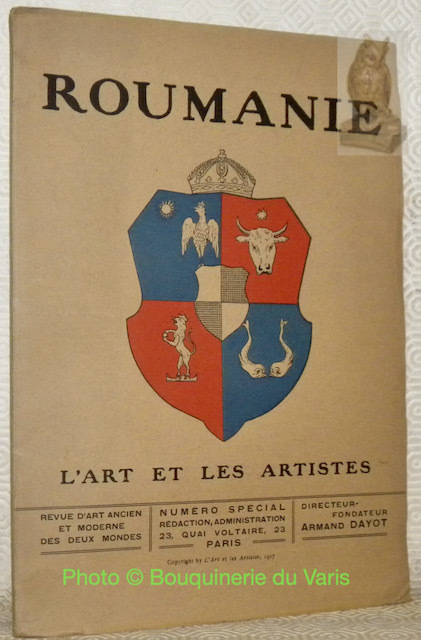
L’Art et les Artistes. Numéro spécial ROUMANIE.
Paris, 1917, 310x210mm, 68pages, broché. Bel exemplaire.
Référence libraire : 55944
|
|
|
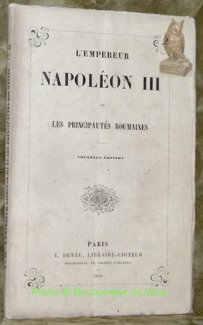
L’empereur Napoléon III et les Principautés roumaines. Nouvelle édition.
Paris, E. Dentu 1858, 225x140mm, 48pages, broché.
Référence libraire : 45145
|
|
|
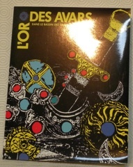
L’or des avars dans le bassin des Carpates VIe-VIIIe siècle. Pavillon des Arts.
Paris, 1986, 270x210mm, 101pages, broché. Exemplaire à l'état de neuf.
Référence libraire : 23093
|
|
|
Maramaros-Sziget - Land: UNGARN (= Specialkarte der ?sterreichisch-Ungarischen Monarchie - 1:75 000 [Zone 14, Colonne XXX. Band: 4555])
Wien, Milit?rgeographisches Institut, [um 1900]. Formatangabe ca 50 x 37 cm, gefaltet zu 8 Segmenten, Ausgabe: einf?rbig ; Zustand: Einzeichnung mit rotem Buntstift, sonst gut
Référence libraire : K-1421

|
|
|
Maramaros-Sziget - Land: Ungarn/ Galizien (= General-Karte von Mittel-Europa 1:200 000. 129. 42? 48?)
Wien, Kaiserlich-K?nigliches Milit?r-Geographisches Institut, [um 1900]. Hochformat, ca. 38 x 55 cm, gefaltet zu 8 Segmenten, Ausgabe: mehrf?rbig; Zustand: Markierungen mit Buntstift, zwei L?cher in rechtem unterem Viertel des Kartenblattes, sonst gut
Référence libraire : K-1430

|
|
|
Maramaros-Sziget - Land: Ungarn/ Galizien (= General-Karte von Mittel-Europa 1:200 000. 129. 42? 48?)
Wien, Kaiserlich-K?nigliches Milit?r-Geographisches Institut, 1914. Hochformat, ca. 38 x 55 cm, Ausgabe: mehrf?rbig; Zustand: gut +
Référence libraire : A111-146

|
|
|
Maramaros-Sziget - Land: Ungarn/ Galizien (= General-Karte von Mittel-Europa 1:200 000. 129. 42? 48?)
Wien, Kaiserlich-K?nigliches Milit?r-Geographisches Institut, 1914. Hochformat, ca. 38 x 55 cm, gefaltet zu 4 Segmenten, Ausgabe: mehrf?rbig; Zustand: Blatt am Rand vollkommen unbeschnitten, Walddruck um etwa 2cm senkrecht nach oben versetzt, sonst gut +
Référence libraire : A141-1259

|
|
|
Maramaros-Sziget - Land: Ungarn/ Galizien (= General-Karte von Mittel-Europa 1:200 000. 129. 42? 48?)
Wien, Kaiserlich-K?nigliches Milit?r-Geographisches Institut, [ca. 1900]. Hochformat, ca. 38 x 55 cm, gefaltet zu 4 Segmenten, Ausgabe: mehrf?rbig; Zustand: gut +
Référence libraire : A141-1258

|
|
|
Maros-Illye -Land: UNGARN (= Specialkarte der ?sterreichisch-Ungarischen Monarchie - 1:75 000 Zone 22 Colonne XXVII [Band: 5669])
Wien, Milit?rgeographisches Institut, 1884. Formatangabe ca 50 x 37 cm, gefaltet zu 8 Segmenten, Ausgabe: einf?rbig ; Zustand: gut
Référence libraire : K-894

|
|
|
Meisterwerke des Expressionismus / Capodopere ale expresionismului. Gemälde und Graphik / Pictura si grafica.
Staatsgalerie Stuttgart., 1972. 24 x 16,5 cm. 121 S. OKarton mit OKlappenumschlag., 2275E Erste Auflage. Kanten etwas berieben, Buchrücken rissg und leicht angestaubt. Sonst gutes Exemplar.
Référence libraire : 2276EB

|
|
|
Mez?kovacshaza und K?rt?s -Land: UNGARN (= Specialkarte der ?sterreichisch-Ungarischen Monarchie - 1:75 000 Zone 20, Colonne XXIV [Band: 5466])
Wien, Milit?rgeographisches Institut, 1912. Formatangabe ca 50 x 37 cm, gefaltet zu 8 Segmenten, Ausgabe: einf?rbig ; Zustand: gut
Référence libraire : K-1181

|
|
|
MIORITA (1972)
20X29, br. ed. ill, con risvolto , pagine non numerate, opuscolo di presentazione dell' opera in sei lingue,Piccolo strappo al dorso, lievi bruniture e segni del tempo, cop. scollata, interno ben conservato, intonso.Luogo di pubblicazione BucarestEditore Editions AlbatrosAnno pubblicazione 1972Materia/Argomento Romania

|
|
|
Mobilier si feronerie populara
1 vol., pagine non numerate, ill. in nero n.t.; 21,5 x 21 cm. Bross. edit. Dedica alla prima pagina bianca. Minime tracce d'uso in copertina
|
|
|
Mogilew - Land: Russland/ Rum?nien (= General-Karte von Mittel-Europa 1:200 000. 132. 45? 48?)
Wien, Kaiserlich-K?nigliches Milit?r-Geographisches Institut, 1915. Hochformat, ca. 38 x 55 cm, Ausgabe: mehrf?rbig; Zustand: gut +
Référence libraire : A111-185

|
|
|
Mogilew - Land: Russland/ Rum?nien (= General-Karte von Mittel-Europa 1:200 000. 132. 45? 48?)
Wien, Kaiserlich-K?nigliches Milit?r-Geographisches Institut, [ca. 1900]. Hochformat, ca. 38 x 55 cm, gefaltet zu 4 Segmenten, Ausgabe: mehrf?rbig; Zustand: gut +
Référence libraire : A141-1254

|
|
|
MOSTRA della sezione artistica [Scuola Romana di Roma], giugno MCMXLII, Valle Giulia.
Roma, Accademia di Romania, 1942, in8 piccolo quadrato, pp. [18], + 16 tavv. f.t. Qualche mancanza al dorso.
|
|
|
Munk?cs - Land: Ungarn (= General-Karte von Mittel-Europa 1:200 000. 127. 40? 48?)
Wien, Kaiserlich-K?nigliches Milit?r-Geographisches Institut, 1914. Hochformat, ca. 38 x 55 cm, Ausgabe: mehrf?rbig; Zustand: gut +
Référence libraire : A111-120

|
|
|
Munk?cs - Land: Ungarn (= General-Karte von Mittel-Europa 1:200 000. 127. 40? 48?)
Wien, Kaiserlich-K?nigliches Milit?r-Geographisches Institut, 1889. Hochformat, ca. 38 x 55 cm, gefaltet zu 8 Segmenten, Ausgabe: mehrf?rbig; Zustand: gut +
Référence libraire : A141-1261

|
|
|
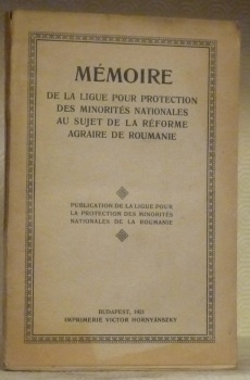
Mémoire de la Ligue pour la Protection des Minorités Nationales sur un sujet de la Réforme Agraire de Roumanie. Publication de la Ligue pour la Protection des Minorités Nationales de la Roumanie.
Budapest, 1921, 240x160mm, 187pages, broché.
Référence libraire : 31083
|
|
|
MÉMOIRE présenté par le Comité de Hongrois Proscrits de Transylvanie à l'"Union Internationale des Associations pour la Société des Nations". Por la défense des droits de la population Hingroise de Transylvanie.
Budapest, Comité de Hongrois... 1922. 144 S., 1 Bl., OKart., abgegriff., Lichtspuren, RüKante oben eingeriss., kl. Eselsohren. In Französisch.
Référence libraire : UNGA0117
|
|
|
Nagy Enyed -Land: UNGARN (= Specialkarte der ?sterreichisch-Ungarischen Monarchie - 1:75 000 Zone 20, Colonne XXIX [Band: 5471])
Wien, Milit?rgeographisches Institut, 1880. Formatangabe ca 50 x 37 cm, gefaltet zu 8 Segmenten, Ausgabe: einf?rbig ; Zustand: gut
Référence libraire : K-1184

|
|
|
Nagy-Banya -Land: UNGARN (= Specialkarte der ?sterreichisch-Ungarischen Monarchie - 1:75 000 Zone 15, Colonne XXIX [Band: 4971])
Wien, Kaiserlich-K?nigliches Milit?r-Geographisches Institut, [um 1912]. Formatangabe ca 50 x 37 cm, gefaltet zu 8 Segmenten, Ausgabe: einf?rbig; Zustand: gut +
Référence libraire : K-1440

|
|
|
Nagy-Szeben (Hermannstadt) - Land: Ungarn/ Rum?nien (= General-Karte von Mittel-Europa 1:200 000. 177. 42? 46?)
Wien, Kaiserlich-K?nigliches Milit?r-Geographisches Institut, 1915. Hochformat, ca. 38 x 55 cm, Ausgabe: mehrf?rbig; Zustand: gut +
Référence libraire : A111-144

|
|
|
Nagy-Szeben (Hermannstadt) - Land: Ungarn/ Rum?nien (= General-Karte von Mittel-Europa 1:200 000. 177. 42? 46?)
Wien, Kaiserlich-K?nigliches Milit?r-Geographisches Institut, 1898. Hochformat, ca. 38 x 55 cm, gefaltet zu 8 Segmenten, Ausgabe: mehrf?rbig; Zustand: gut +
Référence libraire : A141-1288

|
|
|
Nagykikinda-Land: UNGARN (= Specialkarte der ?sterreichisch-Ungarischen Monarchie - 1:75 000 Zone 22 Colonne XXII [Band: 5665])
Wien, Milit?rgeographisches Institut, um 1912. Formatangabe ca 50 x 37 cm, gefaltet zu 8 Segmenten, Ausgabe: einf?rbig ; Zustand: gut
Référence libraire : K-890

|
|
|
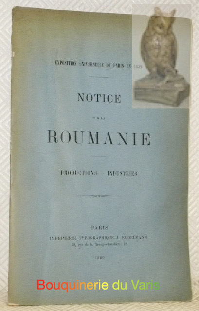
Notice sur la Roumanie. Productions. Industries. Exposition Universelle de Paris en 1889.
Paris, Impr. J. Kugelmann 1889, 240x150mm, 133 + 28pages, broché.
Référence libraire : 20732
|
|
|
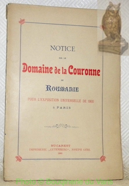
Notice sur le domaine de la Couronne de Roumanie pour l’Exposition Universelle de 1900 à Paris.
Bucarest, Impr. Gutenberg Joseph Göbi 1900, 240x165mm, 111pages, broché. Bel exemplaire.
Référence libraire : 24962
|
|
|
Nyaradt? und Nagy-Kend -Land: UNGARN (= Specialkarte der ?sterreichisch-Ungarischen Monarchie - 1:75 000 Zone 20, Colonne XXXI [Band: 5473])
Wien, Milit?rgeographisches Institut, 1899. Formatangabe ca 50 x 37 cm, gefaltet zu 8 Segmenten, Ausgabe: einf?rbig ; Zustand: gut
Référence libraire : K-1186

|
|
|
Nyir-B?ltek und Hajd?-V?mos-P?rcs -Land: UNGARN (= Specialkarte der ?sterreichisch-Ungarischen Monarchie - 1:75 000 Zone 15 Colonne XXVI [Band: 4968])
Wien, Kaiserlich-K?nigliches Milit?r-Geographisches Institut, um 1915. Formatangabe ca 50 x 37 cm, gefaltet zu 8 Segmenten, Ausgabe: einf?rbig; Zustand: gut +
Référence libraire : K-1438

|
|
|
Oradna und Naszod -Land: UNGARN (= Specialkarte der ?sterreichisch-Ungarischen Monarchie - 1:75 000 Zone 16, Colonne XXXI [Band: 5073])
Wien, Milit?rgeographisches Institut, ca. 1900. Formatangabe ca 50 x 37 cm, gefaltet zu 8 Segmenten, Ausgabe: einf?rbig ; Zustand: gut mit Farbstifteinzeichnungen Milit?r 1. Weltkrieg November 1916
Référence libraire : K-1356

|
|
|
Oradna und Naszod -Land: UNGARN (= Specialkarte der ?sterreichisch-Ungarischen Monarchie - 1:75 000 Zone 16, Colonne XXXI [Band: 5073])
Wien, Milit?rgeographisches Institut, ca. 1900. Formatangabe ca 50 x 37 cm, gefaltet zu 8 Segmenten, Ausgabe: einf?rbig ; Zustand: gut
Référence libraire : K-1191

|
|
|
PAJISTILE DIN MASIVUL PARING SI IMBUNATATIREA LOR.
Bucuresti, Editura Agro-Silvica, Institutul agronomic "Tudor Vladimirescu" Craiova, 1962, Supliment la buletinul stiintific, broché , 18x24,5 cm, 587 pages Nombreuses planches dépliantes. Ouvrage en roumain ?.
Référence libraire : 5442
|
|
|
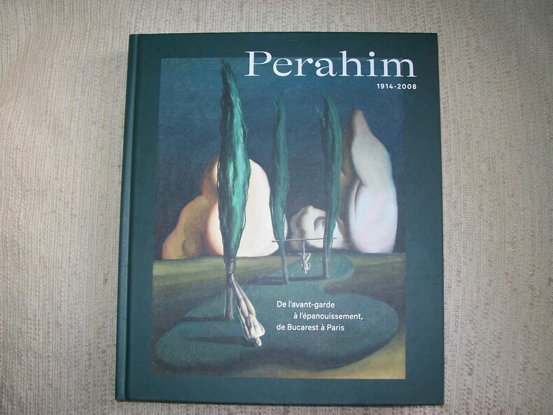
PERAHIM 1914-2008 de l'avant-garde à l'épanouissement, de Bucarest à Paris.
Marseille Musée Cantini Paris Lienart Editions 2021. Grand in-8 191pp. Cartonnage de l'éditeur de papier illustré. Abondante et belle illustration dans le texte ou à pleine page, la plupart en couleurs. Bel exemplaire frais et complet. (4752)
Référence libraire : GITj065
|
|
|
Piano del Porto di Nap. di Romania
Portolano inciso in rame, mm.215x161 relativi alla sola parte incisa, rifilata poco oltre i margini. Veduta della costa, con scandagli espressi in braccia francesi. Da opera stampata in Pisa, 1861. Aloni e ombreggiature di inchiostro. Piccoli interventi di restauro. Non comune.
|
|
|
Ploesti - Land: Rum?nien/ Ungarn (= General-Karte von Mittel-Europa 1:200 000. 203. 44? 45?)
Wien, Kaiserlich-K?nigliches Milit?r-Geographisches Institut, [um 1900]. Hochformat, ca. 42 x 55 cm, gefaltet zu 4 Hauptsegmenten, Ausgabe: mehrf?rbig; Zustand: gut +
Référence libraire : A141-1324

|
|
|
Ploesti - Land: Rum?nien/ Ungarn (= General-Karte von Mittel-Europa 1:200 000. 203. 44? 45?)
Wien, Kaiserlich-K?nigliches Milit?r-Geographisches Institut, 1915. Hochformat, ca. 42 x 55 cm, Ausgabe: mehrf?rbig; Zustand: gut , leicht fleckig
Référence libraire : A111-170

|
|
|
Ramnicu-Valcea - Land: Ungarn/ Rum?nien (= General-Karte von Mittel-Europa 1:200 000. 201. 42? 45?)
Wien, Kaiserlich-K?nigliches Milit?r-Geographisches Institut, [um 1900]. Hochformat, ca. 42 x 55 cm, gefaltet zu 4 Hauptsegmenten, Ausgabe: mehrf?rbig; Zustand: gut +
Référence libraire : A141-1326

|
|
|
Ramnicu-Valcea - Land: Ungarn/ Rum?nien (= General-Karte von Mittel-Europa 1:200 000. 201. 42? 45?)
Wien, Kaiserlich-K?nigliches Milit?r-Geographisches Institut, 1915. Hochformat, ca. 42 x 55 cm, Ausgabe: mehrf?rbig; Zustand: gut +
Référence libraire : A111-143

|
|
|
Rassegna (La) Internazionale. Pubblicazione mensile. Direttore: R. Quintieri. Anno IV - Vol. XIII - Fasc. II e III. (Segnaliamo un ampio articolo su: "Armenia e Macedonia", con contributi di L. Melikow, A. Fogazzaro, G. Sergi, A. De Gubernatis, A.F. Formiggini, C. Lombroso, A. Graf - Fra Ginepro: Sulla via del divorzio fra il papato e la Francia - R. Manzini: Ajaccio - G. Persico: La questione semitica in Romania...).
Roma, Editrice della "Rassegna Internazionale", 1903, fasc. 2 riuniti in volume unico, cop. fittizia (ma conservate le br. edit.), pp. da 129 a 384 in numerazione continua precedute da 8 pp. pubblicitarie per ogni fasc. Con ill. in b.n. nel testo.

|
|
|
Regina Maria di Romania a beneficio della Croce Rossa Tomena
Cartolina con immagine giovanile della Regina in costume tipico, viaggiata. Buona copia.

|
|
|
REVUE roumaine d'histoire. N. 3, 1965.
Bucarest, 1965, in-8, br. edit., pp. 310. (In appendice: Essai de bibliographie sélective concernant l'histoire de Roumanie (P. Cernouvodeanu et P. Simionescu).
|
|
|
Romania d'oggi. Dati storici, geografici, economici, culturali e sociali
17 cm, brossura editoriale; pp. 169, alcune tabelle nel testo

|
|
|
Romania Romana. Colloquio italo-romeno organizzato d'intesa con la Accademia delle Scienze (Roma, 10-11 maggio 1973). Estratto.
Roma, Accademia Nazionale dei Lincei, 1974, in-8, br. edit., pp. numerate da 82 a 104, [4]. Estratto.
|
|
 Recevoir par e-mail
 Télécharger en PDF
 Flux RSS


