|
|
|
[MAP of OTTOMAN PROVINCE of EASTERN ROUMELI].
[MAP of OTTOMAN PROVINCE of EASTERN ROUMELI] Rumeli-yi Sarkî Vilâyeti, Bulgaristan Eyâleti, Edirne Vilâyeti, [Trakya], Selânik Vilâyeti. [East Roumeli, Salonica, Adrianople provinces; Old Zagra Sandjak, Bulgarian State].
Very Good Turkish, Ottoman (1500-1928) Original color map. Folded. Very good. Large oblong 8vo. (21 x 26 cm). In Ottoman script. [MAP of OTTOMAN PROVINCE of EASTERN ROUMELI] Rumeli-yi Sarkî Vilâyeti, Bulgaristan Eyâleti, Edirne Vilâyeti, [Trakya], Selânik Vilâyeti. [East Roumeli, Salonica, Adrianople provinces; Old Zagra Sandjak, Bulgarian State]. Scale: 1/1.500.000. Ottoman Provinces in the Balkan Peninsula.
|
|
|
[MAP of OTTOMAN PROVINCE of ERZURUM].
[MAP of OTTOMAN PROVINCE of ERZURUM] Erzurum Vilâyeti.
Very Good Turkish, Ottoman (1500-1928) Original color map. Folded. Very good. Large oblong 4to. (19 x 37 cm). In Ottoman script. [MAP of OTTOMAN PROVINCE of ERZURUM] Erzurum Vilâyeti. Province of Erzurum of east Anatolia and its around. Many sandjaks and provinces with their detailed place names. Scale: 1/1.500.000.
|
|
|
[MAP of OTTOMAN PROVINCE of KONIA].
[MAP of OTTOMAN PROVINCE of KONIA] Konya Vlâyeti and around; Burdur, Isparta, Teke sandjaks, Hüdavendigâr Province Tozlu Ova, Tuz Gölü etc.
Very Good Turkish, Ottoman (1500-1928) Original color map. Folded. Very good. Oblong 4to. (21 x 42 cm). In Ottoman script. [MAP of OTTOMAN PROVINCE of KONIA] Konya Vlâyeti and around; Burdur, Isparta, Teke sandjaks, Hüdavendigâr Province Tozlu Ova, Tuz Gölü etc. Scale: 1/500.000.
|
|
|
[MAP of OTTOMAN PROVINCE of SIVAS].
[MAP of OTTOMAN PROVINCE of SIVAS] Sivas Vilâyeti, Trabzon Vilâyeti, Tokat Sancagi. [Sivas and Trabzon Provinces, Tokat Sandjak].
Very Good Turkish, Ottoman (1500-1928) Original color map. Folded. Very good. Large oblong 8vo. (26 x 26 cm). In Ottoman script. [MAP of OTTOMAN PROVINCE of SIVAS] Sivas Vilâyeti, Trabzon Vilâyeti, Tokat Sancagi. [Sivas and Trabzon Provinces, Tokat Sandjak]. Scale: 1/1.500.000.
|
|
|
[MAP of OTTOMAN PROVINCE of SIVAS].
[MAP of OTTOMAN PROVINCE of SIVAS] Sivas Vilâyeti, Trabzon Vilâyeti, Tokat Sancagi. [Sivas and Trabzon Provinces, Tokat Sandjak].
Very Good Turkish, Ottoman (1500-1928) Original color map. Folded. Very good. Large oblong 8vo. (26 x 26 cm). In Ottoman script. [MAP of OTTOMAN PROVINCE of SIVAS] Sivas Vilâyeti, Trabzon Vilâyeti, Tokat Sancagi. [Sivas and Trabzon Provinces, Tokat Sandjak]. Scale: 1/1.500.000.
|
|
|
[MAP of OTTOMAN PROVINCE of TREBIZOND].
[MAP of OTTOMAN PROVINCE of TREBIZOND] Trabzon Vilâyeti, Trabzon Sancagi, Canik Sancagi, Sivas Vilâyeti. [Provinces of Trabzon and Sivas; Canik and Trebizond Sandjak].
Very Good Turkish, Ottoman (1500-1928) Original color map. Folded. Very good. Obblong 4to. (21 x 38 cm). In Ottoman script. Scale:: 1/500.000. [MAP of OTTOMAN PROVINCE of TREBIZOND] Trabzon Vilâyeti, Trabzon Sancagi, Canik Sancagi, Sivas Vilâyeti. [Provinces of Trabzon and Sivas; Canik and Trebizond Sandjak]. Black Sea at north.
|
|
|
[MAP of OTTOMAN SALONIQUE].
[MAP of OTTOMAN SALONICA -THESSALONIKI-] Selânik Vilâyeti.
Very Good Turkish, Ottoman (1500-1928) Original color map. Folded. Very good. Large oblong 8vo. (21 x 26 cm). In Ottoman script. [MAP of OTTOMANT SALONICA -THESSALONIKI-] Selânik Vilâyeti. Ottoman Greece. Scale: 1/1.500.000. It shows Thessaloniki and its around. Manastir Vilayat, At north Kosovo, Siroz Sandjak etc.
|
|
|
[Mauri Carlo].
Storia e descrizione delle chiese distrutte ed esistenti oggigiorno in Milano, Corpi Santi e dintorni. [..].
In-16° (cm. 17,8), legatura recente in t. tela; pp. [2] 171 [3] oltre a 1 antiporta e 1 primo frontespizio incisi con inchiostro blu e con raffigurazione di 5 chiese milanesi; bruniture. Edizione originale di una guida per il clero ambrosiano che comprende il Santuario di Saronno, la Certosa di Pavia, il Sacro Monte sopra Varese. Cfr. Villa 251; Hoepli 1291. Buon esemplare.
|
|
|
[MENARDIE (J.)]
Guide du canton de Riom-ès-Montagnes. Cure d'air. Excursions.
S.l., (1960); in-8, 23 pp., ill., broché.
Referentie van de boekhandelaar : 218771
|
|
|
[MEXIQUE].-
Nagel encyclopédie de voyage. MEXIQUE.
P., Genève, Munich, Nagel, 1968, in 12 reliure toile rouge de léditeur, jaquette, 608 pages ; petits frottis à la jaquette.
Referentie van de boekhandelaar : 43305
|
|
|
[Meschinello Giovanni Antonio].
Le due chiese di S. Antonio e di S. Giustina. L'orto de' semplici, le accademie, le pitture principali delle chiese, e il catalogo de' corpi santi.
In-12° (cm. 15,3), brossura marmorizzata coeva (slegata), pp. 84 con 1 tavola di ritratto del santo in antiporta, 2 tavole illustrative ripiegate f.t.; sporadiche fioriture e qualche carta sciolta. Non comune. Esemplare più che discreto.
|
|
|
[MICHAL-LADICHERE (François-Alexandre)]
Guide du voyageur à Grenoble. dans ses environs et aux eaux thermales du département de l'Isère, contenant diverses notices historiques, une carte et neuf dessins lithographiés
Grenoble, Charles Vellot, 1845 in-8 oblong, 82 pp., un f. n. ch. de table, avec 10 planches hors texte (dont une carte, un panorama de Grenoble gravé au trait, et 8 vues lithographiées), demi-chagrin cerise, dos à nerfs (rel. un peu postérieure).
Referentie van de boekhandelaar : 217762
|
|
|
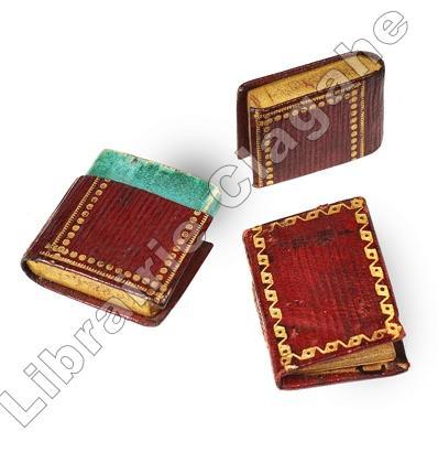
[Minuscule]
Le Petit paroissien de l'enfance.
Paris, Caillot, rue S. André des Arts, n.57, s.d. (avant 1811, date à laquelle il n’est pas maintenu comme imprimeur) ; minuscule 30 x 20,5 mm, maroquin grenat à grain long, roulette décorative d’encadrement des plats, gros pointillé doré au dos, tranches dorées, étui en forme de livre relié : 36 x 25 mm, maroquin grenat à grain long, dos à faux nerfs et fleurons dorés, double encadrement des plats, pointillé fin et pointillé gras, tranches dorées (reliure de l’époque) ; 80 pp. y compris le titre.
Referentie van de boekhandelaar : 20240
|
|
|
[Michelin]
Michelin Italie 1960.
français Michelin, Durin et Cie, 1960. In-8 de 323 pp.; cartonnage rouge imprimé en noir de l'éditeur. Bon état.
|
|
|
[Michelin].
Guide Vert Michelin. 1959.
Un volume broché en hauteur de 254 pp.; très nombreuses cartes , plans de ville... Bon état. Voir photos. Commentaires élogieux sur des sites encore tranquilles dans ces "années 50". Peu courant.
|
|
|
[MILITARY PRINTINGHOUSE].
[MAP of HELLESPONT & GALLIPOLI] [Map of Hellespont, Gallipoli Peninsula, Suvla Bay, Seddülbahir and Tenedos].
Very Good Turkish, Ottoman (1500-1928) Original color map. 65,5x63 cm. In Ottoman script. This rare and decorative Gallipoli map including Hellespont, Gallipoli Peninsula, Suvla Bay, Seddülbahir, and Tenedos, the places of Gallipoli Aar in 1915 (Dardanelles Campaign) during World War 1, separated two map views. Seddulbahir and Suvla Bay at north and Straight, Peninsula, and its shores with Tenedos (now Bozcaada) at the southwest of the map. It's a very detailed and rare map printed with the series of "History of the Dardanelles Campaign" after the seven years of war. The Gallipoli campaign, also known as the Dardanelles campaign, the Battle of Gallipoli or the Battle of Çanakkale (Turkish: Çanakkale Savasi, or, Muharebâti), was a military campaign in the First World War that took place on the Gallipoli peninsula (Gelibolu in modern Turkey), from 17 February 1915 to 9 January 1916. The Entente powers, Britain (with Anzacs), France, and Russia, sought to weaken the Ottoman Empire, one of the Central Powers, by taking control of the Turkish straits.
|
|
|
[MISSIONARY GUIDE BOOK]
The missionary guide-book; or a key to the protestant missionary map of the world: shewing the geography natural history climate population and government of the several countries to which missionary efforts have been directed; with the moral social and religious condition of their inhabitants.
London: Seeley Burnside and Seeley 1846. 2 xix 1 472pp. With an engraved folding map and 45 woodcut illustrations in the text. Original publisher's blind-stamped green cloth lettered in gilt to spine. Lightly rubbed marked spine sunned. Internally clean and crisp. 'Let us all pray for New Zealand that it may please Almighty God to avert the evils of a civil war from this newly-acquired and interesting colony'. The sole edition of an authoritative work of ecclesiastical geography that provides a detailed account of the rise and progress of Protestant missions throughout the world. The anonymous compiler provides detailed information on the political and colonial history of the regions in which missionaries laboured as well as valuable accounts of the 'superstitions' of the natives including instances of human sacrifice the 'prevalence of Paganism and Mahommetanism' cannibalism and the practice of 'Devil-Worship'. The majority of the text is devoted to the missions of Africa and India though extensive chapters relate Christian efforts in inter alia the West Indies Australasia and North America. In regards to West Indies the author provides notices on the origin of the Slave Trade its abolition and the death of the 'ever-to-be revered Mr. Wilberforce'. The chapter concerning North America is predominantly dedicated to Canada in particular the operations of the Hudson's Bay Fur Companies and the 'Native Indians of these Territories favourable to British trade'. The chapter concerning Australasia is divided between New Holland and New Zealand and notably include remarks in character and appearance of the Aborigines and 'the most warlike savages in the world' the New Zealanders respectively. The section on New Zealand strikingly concludes with a brief account of the eruption of conflicts between British and native forces that would prove to be the initial sorties of the bloody and protracted New Zealand Wars. . First edition. 8vo. Seeley, Burnside, and Seeley hardcover
Referentie van de boekhandelaar : AQ31443
|
|
|
[MONTAGNE] - [Guide VALLOT] - HENRY (Pierre) - ICHAC (Marcel) avec la collaboration de GAYET-TANCREDE (Paul) [SAMIVEL] .-
Groupes de Trelatête et de Miage (entre les cols de Miage, de la Seigne et du Bonhomme).
P., Fischbacher, 1933, in 12 relié pleine percaline bleue de l'éditeur, 117 pages.
Referentie van de boekhandelaar : 49951
|
|
|
[MONTAGNE] - KURZ (Marcel).-
Guide des Alpes Valaisannes.
Zollikon, CAS, 1919-1963, 4 volumes in 12 reliés pleine toile de l'éditeur.
Referentie van de boekhandelaar : 49495
|
|
|
[MONTAGNE] - KURZ (Louis).-
Guide de la Chaine du Mont Blanc à l'usage des alpinistes. 4e édition revue et mise à jour par Marcel Kurz.
Lausanne, Payot, 1935, in 12 reliure pleine percaline bordeaux de l'éditeur, 501 pages ; infime frotti sur le 1er plat.
Referentie van de boekhandelaar : 49496
|
|
|
[MONTAGNE] - GAILLARD (Emile).-
Guide Gaillard des Alpes de Savoie (Tome premier), les massifs entre l'Arc et l'Isère. Première partie : Au Nord du Col de la Vanoise. Guide pour l'alpiniste.
Chambery, Editions Lire, 1947, in 12 broché, XI-257 pages ; nombreux dessins et croquis certains dépliants.
Referentie van de boekhandelaar : 49501
|
|
|
[MONTAGNE].-
Guide des sentiers de Montagne. Commune de PASSY.
Bonneville, Liberti-Jourdan, 1979, petit in 12 broché, 73 pages ; couverture illustrée ; nombreux croquis.
Referentie van de boekhandelaar : 49506
|
|
|
[MONTROUGE].-
Indicateur Officiel de la Ville 1924.
8°année. Rues, Plan, Monographie, Partie administrative, etc., Avec le Commerce et l'Industrie. Gd in-8 br.56pp.
Referentie van de boekhandelaar : ORD-7563
|
|
|
[MONTAGNE] - [Guide VALLOT] - G. H. M.-DEVIES (Lucien) et HENRY (Pierre).-
La chaine du Mont Blanc. Aiguille verte - Dolent - Argentière - Trient.
P., Grenoble, 1949, in 12 plein cartonnage beige de l'éditeur, 381 pages.
Referentie van de boekhandelaar : 49945
|
|
|
[MONTAGNE] - [Guide VALLOT] - DEVIES (Lucien), HENRY (Pierre), LAGARDE (Jacques) - G.H.M.-
La Chaine du Mont Blanc. Mont Blanc - Trélatête.
P., Grenoble, Arthaud, 1946, in 12 cartonnage bleu de l'éditeur, 335 pages ; dos décollé renforcé au scotch, cartonnage défraichi.
Referentie van de boekhandelaar : 49947
|
|
|
[MONTAGNE] - [Guide VALLOT] - DEVIES (Lucien) et HENRY (Pierre).-
La chaine du Mont-Blanc. III : Aiguille verte - Triolet - Dolent - Argentière - Trient.
Grenoble, Arthaud, 1959, in 12 pleine reliure toile verte de l'éditeur, 451 pages ; 80 figures.
Referentie van de boekhandelaar : 52361
|
|
|
[MONTAGNE] - PREVOST (Edouard).-
Sommets pour tous.
Chambery, Imprimeries réunies, 1977, petit in 12 reliure orange souple de l'éditeur, 230 pages ; nombreux croquis.
Referentie van de boekhandelaar : 49493
|
|
|
[MONTAGNE] - RAVELLI (Don Luigi).-
Valsesia e monte Rosa. Guide alpinistico, artistico, storico. Volume I : Alagna Sesia e monte Rosa. IV edizione.
Varallo, CAI, 1962, in 12 reliure cartonnée de l'éditeur, 125 pages ; ilustrations hors-texte en couleurs.
Referentie van de boekhandelaar : 49499
|
|
|
[MULHOUSE, GUIDE] - LOLIGER (Claudine), BOEGLIN (Edouard) -
Le guide de mulhouse.
Jena, Editions de la manufacture, 1993 ; grand in-12, 178 pp., cartonnage de l'éditeur. Les vallées de la thur et de la doller, le florival, le sundgau, belfort, montbéliard et la <<régio…>>.
Referentie van de boekhandelaar : 200713550
|
|
|
[N. A.].
[OTTOMAN MILITARY MAP of PATAGONIA and FALKLAND ISLANDS: ROUTE of DRESDEN] Alman kruvazörü Dresden'in takîbi ve tahrîbi.
Very Good Turkish, Ottoman (1500-1928) Original color map. Elephant folio. (59x75 cm). In Ottoman script. [OTTOMAN MILITARY MAP of PATAGONIA and FALKLAND ISLANDS: ROUTE of DRESDEN] Alman kruvazörü Dresden'in takîbi ve tahrîbi. SMS Dresden cruiser's routes between 1913-1915 (World War 1) on the Patagonian shelf; western shores of South America, Patagonia and Falkland Islands. Dresden spent much of her career overseas. After commissioning, she visited the United States in 1909 during the Hudson-Fulton Celebration, before returning to Germany to serve in the reconnaissance force of the High Seas Fleet for three years. In 1913, she was assigned to the Mediterranean Division. She was then sent to the Caribbean to protect German nationals during the Mexican Revolution. In mid-1914, she carried the former dictator Victoriano Huerta to Jamaica, where the British had granted him asylum. She was due to return to Germany in July 1914, but was prevented by the outbreak of World War I from doing so. At the onset of hostilities, Dresden operated as a commerce raider in South American waters in the Atlantic, then moved to the Pacific Ocean in September and joined Maximilian von Spee's East Asia Squadron. Dresden saw action in the Battle of Coronel in November, where she engaged the British cruiser HMS Glasgow, and at the Battle of the Falkland Islands in December, where she was the only German warship to escape destruction. She eluded her British pursuers for several more months, until she put into Robinson Crusoe Island in March 1915. Her engines were worn out and she had almost no coal left for her boilers, so the ship's captain contacted the local Chilean authorities to have Dresden interned. She was trapped by British cruisers, including her old opponent Glasgow. The British violated Chilean neutrality and opened fire on the ship in the Battle of Más a Tierra. The Germans scuttled Dresden and the majority of the crew escaped to be interned in Chile for the duration of the war. The wreck remains in the harbor; several artifacts, including her bell and compass, have been returned to Germany.
|
|
|
[N.A.]
A guide to Çatalhöyük. Translated by Hasan Inal.
Very Good English Paperback. Pbo. Cr. 8vo. (19 x 13 cm). In English. [14] p. Booklet. B/w and color ills. A guide to Çatalhöyük. Translated by Hasan Inal.
|
|
|
[N.A.].
Agriculture in Turkey. Some key information for foreign investors.
Very Good English Paperback. Pbo. Roy. 8vo. (24 x 17 cm). In English. 95 p. Ex-library copy. Agriculture in Turkey. Some key information for foreign investors.
|
|
|
[N.A.].
Negotiating in Asia: A buyer's manual for successful negotiation in selected Asian markets.
Fine English Paperback. Pbo. Demy 8vo. (22 x 15 cm). In English. [4], 109, [5] p., b/w ills. Negotiating in Asia: A buyer's manual for successful negotiation in selected Asian markets.
|
|
|
[NATURE, FRANCE, GUIDE]
La natue en france itinéraires et guide visuel pour tout reconnaitre en un clin d oeil.
Paris, Selection du reader's digest, 2007 ; in-4, 400 pp., br.
Referentie van de boekhandelaar : 201411530
|
|
|
[NANTES]
Le Conducteur de l'étranger à Nantes. contenant la description complète des monuments anciens et modernes, des musées, des promenades, des sites et des points de vue. Seconde édition
Nantes, Prosper Sebire, s.d. in-16, IX-150-(5) pp., front. replié, 4 planches dont 2 repliés, dérelié, tranches rouges.
Referentie van de boekhandelaar : 219577
|
|
|
[NATURE - CAMPAGNE]
Les Mille Visages de la campagne française. Guide encyclopedique illustre.
petit in-4° etroit, 628 pages entièrement illustrees en couleurs, cartes, gloss., index, relie pleine toile grège ed. Bel exemplaire. [P-38]
|
|
|
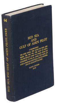
[NAVIGATION - RED SEA - PILOT GUIDE].
Red Sea and Gulf of Aden pilot comprising the Suez canal the Gulfs of Suez and 'aqaba the Red Sea the Gulf of Aden the South-east coast of Arabia from Ras Baghashwa to Ras al Hadd the coast of Africa from Ras Asir to Ras Hafun Socotra and its adjacent islands. Tenth edition.
London 1955. 8vo. Published for the Hydrographic Department Admiralty Original blue cloth with yellow lettering on the spine and the front board the supplement is loosely inserted at the end of the volume: original printed paper wrappers stapled. With a folding map printed on both sides 2 coloured plates with diagrams printed on both sides 28 plates showing coastlines and occasionally a map many printed on both sides and many some illustrations in text. 2 LI = LIII: II plus 1 1 blank 1 blank 518 1 1 blank pp; Supplement: 20 pp. The essential standard sailing directions for the Red Sea and Gulf of Aden corresponding with zone NP64 on the official Admiralty charts. These nautical works - pilot guides and charts - were published by the United Kingdom Hydrographic Office which provides the necessary hydrographic and marine geospatial data to all kinds of maritime organisations across the world. The publications are not only used by the British Royal Navy but can also be found on board the majority of international merchant ships. The data provided in the pilot guides and other publications are compliant with SOLAS the Safety of Life at Sea treaty guidelines and are updated constantly in weekly "Notices to mariners" and supplements to and new editions of the pilot guides whenever necessary.The present copy is the 10th edition 1955 of the pilot guide with sailing directions and other information on the weather currents radar ranges etc. relating to the Red Sea and Gulf of Aden including the supplement issued in 1957. It includes an erroneous "advertisement to the eight edition" by the Hydrographer of the Navy Rear-Admiral Kenneth St Barbe Collins 1904-1982. The advertisement states that with the publication of "the ninth edition" presumably this volume the previous edition and its supplements are cancelled since the most up-to-date information has been compiled in the new edition and the weekly "Notices to mariners" that appeared after the publication of the 11th edition. The 10th edition of 1955 and its 1957 supplement were made redundant with the publication of the 11th edition in 1967. Each subsequent edition of the pilot supersedes the last which have appeared infrequently depending on newly available information from the mid-19th century until the present day.The front paste-down and recto of the first free endpaper contain a "caution" notice and room for the notation of "supplements and annual summaries of notices to mariners relating to this book" the first two pages are printed on red-pink paper. The binding shows minor signs of wear around the spine and corners of the boards the gutter after page II is somewhat weakened the head edge of the wrappers of the supplement are very slightly browned. Otherwise in very good condition. hardcover
Referentie van de boekhandelaar : ABC_47446
|
|
|
[NAVIGATION - RED SEA - PILOT GUIDE].
Red Sea and Gulf of Aden pilot comprising the Suez Canal the Gulfs of Suez and Aqaba the Red Sea the Gulf of Aden the South-East coast of Arabia from Ras Baghashwa to Ras Al Hadd the coast of Africa from Ras Asir to Ras Hafun Socotra and its adjacent islands.
London: United Kingdom Hydrographic Office 1967. Grey-blue back wrapper; the two quires map and back wrapper held together by two metal staples. Blue cloth with title information in yellow on front cover and spine the supplement loosely inserted at the end of the volume. Large 8vo. The main work with 3 maps including 2 folding and 82 views of coastal profiles on 52 plates. The supplement with 2 folding maps on the two sides of a single folding leaf and 4 views of coastal profiles on 3 pages. With: NAVIGATION - RED SEA - PILOT GUIDE. Supplement No. 7 - 1977 to Red Sea and Gulf of Aden pilot eleventh edition 1967 corrected to 4th March 1977 Whenever reference is made to the pilot this supplement must be consulted.London United Kingdom Hydrographic Office 1977. The essential standard sailing directions for the Red Sea and Gulf of Aden corresponding with zone NP64 on the official Admiralty charts. These nautical works - pilot guides and charts - were published by the United Kingdom Hydrographic Office which provides the necessary hydrographic and marine geospatial data to all kinds of maritime organisations across the world. The publications are not only used by the British Royal Navy but can also be found on board the majority of international merchant ships. The data provided in the pilot guides and other publications are compliant with SOLAS the Safety of Life at Sea treaty guidelines and are updated constantly in weekly "Notices to mariners" and supplements to and new editions of the pilot guides whenever necessary.The present copy is the 11th edition 1967 of the pilot guide with sailing directions and other information on the weather currents radar ranges etc. relating to the Red Sea and Gulf of Aden including the supplement issued in 1977. The first two pages are printed on red-pink paper. Binding slightly rubbed and faded board edges very slightly soiled fore-edge of the supplement slightly frayed. Overall in good condition. United Kingdom Hydrographic Office, hardcover
Referentie van de boekhandelaar : ABC_46470
|
|
|
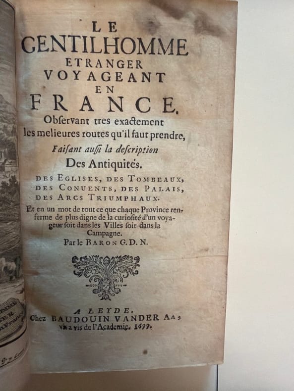
[NEMEITZ (Joachim Christoph von)].
Le Gentilhomme étranger voyageant en France. Observant très exactement les melieures (sic) routes qu'il faut prendre, faisant aussi la description des antiquités, des églises, des tombeaux, des convents, des palais, des arcs triumphaux. Et en un mot de tout ce que chaque province renferme de plus digne de la curiosité d'un voyageur soit dans les villes soit dans la campagne. Par le baron G. D. N
Leyde, Baudouin Van der Aa, 1699 in-16, [3] ff. n. ch. (titre, préface), 241 pp., [3] pp. n. ch. de catalogue, avec un frontispice gravé par Jan Goeree, basane fauve marbrée, dos à nerfs cloisonné et fleuronné, pièce de titre, double filet à froid latéral sur les plats, tranches rouges (reliure de l'époque). Coins abîmés, quelques mouillures claires.
Referentie van de boekhandelaar : 240484
|
|
|
[NORMANDIE].-
Guides Bleus. Normandie.
Hachette, 1933, in 12 cartonnage bleu de l'éditeur, LXL-512 pages.
Referentie van de boekhandelaar : 46454
|
|
|
[NORMANDIE] - [Guides Bleus].-
Guides bleus illustrés. ROUEN.
P., Hachette, 1932, in 12 broché, 72 pages ; illustrations.
Referentie van de boekhandelaar : 46568
|
|
|
[NORMADIE] - [Guides Pratiques CONTY].-
Guides Pratiques Conty. Collection des Guides Circulaires, publiés sous le patronage des Compagnies de Chemins de fer. CÔTES de NORMANDIE. Guide Circulaire correspondant aux voyages de plaisir organisés par la Compagnie de l'Ouest. Huitième édition.
P., Office des Guides Conty, sans date (1888), fort volume petit in 12 relié pleine percaline bleue de l'éditeur, 366 pages - 75 pages sur papier bleu (Agenda du voyageur - Hotels et Maisons recommandés) - 72 pages (Annonces industrielles) et IV pages ; très nombreuses illustrations ; quelques traits de crayon dans les marges ; quelques rousseurs ; cartonnage légèrement frotté, ors un peu passés.
Referentie van de boekhandelaar : 52039
|
|
|
[NORMANDIE] - [Guides DIAMANT].-
Rouen et ses environs.
P., Hachette, 1921, petit in 12 broché, 64 pages et 156 pages de publicités ; couverture rouge.
Referentie van de boekhandelaar : 55609
|
|
|
[OCEANIE, GUIDES BLEUS] - VILLARET (Bernard) -
OCEANIE.
Paris, Les albums des guides bleus, 1955 ; in-8, 125 pp., cartonnage d'éditeur avec jaquette. 12e titres de la collection - bon état mais rousseurs (avec sa jaquette bien usagée).
Referentie van de boekhandelaar : 201508584
|
|
|
[OCEAN LINERS -- TRAVEL GUIDE].
Guide through Germany Austria-Hungary Switzerland Italy France Belgium Holland The United Kingdom Spain Portugal &c. . . Souvenir of the Hamburg-American Line.
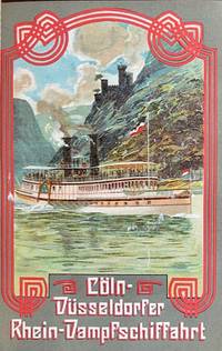
Berlin: Hamburg-American Line J. Hermann Herz 1907. 12mo. 887 1 pp. Approx. 920 pp. including inserts duplicate numbering inserts. With 22 colour inserts plates chromolithograph folding panoramas chromolith pictorial maps colour-printed inserted ads numerous photo plates plates illustrated ads street maps maps. Pictorial red publisher’s cloth gilt black & white lettering front cover black advertising lettering spine & back cover minor shelfwear chipping & faint reinforcement to ffep. uniform interior toning as usual slight offsetting to a couple of the chromolith inserts ex-lib marking foot of spine title still G copy. Eighth edition of this detailed and nicely illustrated brochure for Hamburg-American Line ocean liner passengers detailing hotels restaurants museums and sights throughout Europe. Of particular interest are the beautifully printed chromolithograph inserts including steamships down the Rhine on the Coln-Dusseldorfer steamships; colour insert & map for the Rhaetian Railway Grisons Switzerland colour views traveling through Switzerland on the Montreux-Oberland Bernois railroad and the Bucher-Durrer’s Hotels folding panorama of seven lakes and peaks in the Swiss Alps. Hamburg-American Line, J. Hermann Herz, hardcover
Referentie van de boekhandelaar : 59689
|
|
|
[OISE].-
Abbaye de Chaalis et Musée Jacquemart-André.-
Notice et Guide sommaire des monuments, des collections et de la Promenade du Désert. Avec 24 planches hors texte et 2 cartes en couleurs. Paris. Bulloz. s.d. In-8 (133 x 183mm) broché, couverture imprimée noir et rouge, 127 pages. Bon exemplaire.
Referentie van de boekhandelaar : ORD-7908
|
|
|
[ORANGE].-
Guide indicateur d'Orange. Description - Historique. Plan de la ville avec renseignements utiles aux voyageurs et aux touristes.
Orange, Sibourg, sans date (vers 1900), in 12 broché, 96 pages + 14 pages de publicités.
Referentie van de boekhandelaar : 17143
|
|
|
[ORANIE].-
L'Oranie pittoresque.-
Publié par le Syndicat d'Initiative de l'Oranie. s.d. (début XX°). In-8 (128 x 209mm) broché (attaché par un cordonnet); couverture illustrée couleurs et photos, 21 pages, nombreuses illustrations dans le texte et publicités, carte de la méditerranée en dernière de couverture. Couverture lgt abîmée, bon état intérieur. Charmant guide.
Referentie van de boekhandelaar : ORD-7928
|
|
|
[OSMAN] SAFVET [GEYLANGIL], (1887-1944).
[BEAUTIFUL CHROMOLITHOGRAPHED MAPS / OTTOMAN ATLAS] Yeni resimli ve haritali cografya-yi Osmanî. Mekâtîb-i Ibtidâiyye Devre-i Aliye birinci sinifa mahsus.
Very Good Turkish, Ottoman (1500-1928) Contemporary red cloth. Roy. 8vo. (24 x 16 cm). In Ottoman script (Old Turkish with Arabic letters). [1], 229, [1] p., many b/w and color ills., 30 chromo-lithographed maps. Wear and fading on spine, some ex-library stamps on the colophon and several blank pages, ownership ink inscription and signature on the first page-overall a good copy. First edition of this rare Ottoman atlas for the primary schools in the late Ottoman Empire, including beautiful 30 chromo-lithographed maps of the Ottoman land according to administrative regions (provinces) and richly illustrated with b/w plates of the cities and provinces in the Middle East. Map list: 1. World map 2. Complete Imperial Ottoman 3. Arabian Peninsula 4. Anatolia 5. Asia Minor 6. Marmara and Black Sea 7. Aegean (The Archipelago) 8. Demography of Anatolia and Syria, Libya, etc 9. Administrative map of Anatolia 10. Map of mines of Anatolia 11. Agricultural map of the Imperial Ottoman 12. Arabian Peninsula 13. Map of the Edirne Vilayat [Adrianople Province of the Ottoman Empire] 14. Map of the Bosphorus 15. Map of the Hüdavendigâr Vilayat [Brusa Province] 16. Maps of Izmit and Biga Sanjaks 17. Map of Aydin Vilayat and Mentese Sanjak 18. Map of the Konya Vilayat 19. Maps of the Adana Vilayat and the Mediterranean Sea 20. Maps of the Erzurum and Ankara Vilayats 21. MAps of Kastamonu Vilayat and Bolu Sanjak 22. Map of the Trebizond Vilayat 23. Maps of the Van and Bitlis Vilayats 24. Maps of the Sivas and Harput Vilayats 25. Maps of the Bagdad and Basrah Vilayats 26. Map of the Mosul Vilayat and Day al-Zor Sanjak 27. Map of the Aleppo Vilayat and Urfa Sanjak 28. Map of the Syria and Beirut Vilayats 29. Map of the Arabia 30. Maps of the Yemen vilayat and Asir Sanjak. This atlas was printed four times for the different classes of the early Turkish / Ottoman schools, during World War 1 (two times in 1916) and the National Struggle (two times in 1921). Geylangil was born in Istanbul in 1887 and studied in Aleppo and Baghdad. Geylangil, who also studied economic geography, taught geography at many schools, including Galatasaray High School. Until his death, he wrote 14 books on geography, most of which were geographical atlases. In 1941, he was among the founding members of the Turkish Geographical Society. Özege 23216.; TBTK 11481.; We couldn't find any copy of this edition worldwide.
|
|
|
[PARIS] - [Guides Pratiques CONTY].-
Guides Pratiques Conty. PARIS en POCHE. Dix-neuvième édition.
Paris, Guides Conty, sans date (vers 1900), fort volume petit in 12 relié pleine percaline bleue de l'éditeur, 392-72-VIIIpp et de nombreuses pages de publicités non chiffrées ; très nombreuses illustrations ; cachets ex-libris ; sans la carte dépliante volante.
Referentie van de boekhandelaar : 29148
|
|
|

 De zoekresultaten per email ontvangen
 Zoekresultaten downloaden als PDF
 RSS feed
 Permanente link


