|
|
|
Erina Gavotti
Erbe e bellezza Il sole, l'acqua, i fiori, le foglie, il vento, gli alberi, la pioggia: 280 consigli per essere più belli
Legatura datata, copertina in robusto cartonato illustrata, segnata da piccoli urti alle estremità e generale scoloritura, toni leggermente velati da polvere e umido, casto corredo illustrativo arricchisce 280 consigli per la bellezza, sporadiche fioriture ai fogli avvolti da ossidazione vintage, intensa ai margini e scura ai tagli. N. pag. 178. USATO

|
|
|
Erina Gavotti
Erbe e bellezza Il sole, l'acqua, i fiori, le foglie, il vento, gli alberi, la pioggia; 280 consigli per essere più belli
Illustrazioni presenti nel volume. Il volume si presenta in buono stato di conservazione. Il dorso e le copertine mostrano lievi segni di usura, piegature al dorso. Le pagine interne sono ingiallite dal tempo e fruibili. I tagli bruniti e regolari. La cerniera è ben salda. Numero pagine 259 USATO

|
|
|
Eringer Travel Guide
The Magic Principality: A Pocket Guide to Monaco-Monte Carlo Eringer Travel Guide
Bartleby Pr. Used - Good. Ships from Reno NV. Shows some signs of wear and may have some markings on the inside. 100% Money Back Guarantee. Shipped to over one million happy customers. Your purchase benefits world literacy! Bartleby Pr unknown
Riferimento per il libraio : GRP96229552 ISBN : 0910155305 9780910155304

|
|
|
Erismann Theodor:
Allgemeine Psychologie I
Walter de Gruyter Berlin 1965. Walter de Gruyter Berlin, 1965. unknown
Riferimento per il libraio : 137205
|
|
|
ERKÂN-I HARBIYE UMUMIYE].
[MAP of Kharpout] Harput. Dersim, Palu, Malatya, Siverek.
Very Good Turkish, Ottoman (1500-1928) Original map. Oblong elephant folio. (50 x 60 cm). In Ottoman script. Scale: 1/200.000. [MAP of Kharpout]. Harput. Dersim, Palu, Malatya, Siverek. Rare Ottoman map shows Elaziz (Elazig), Dersim, ancient Harput et environment. This is one the serie of the Bonn projection maps which are the first map series in modern techniques in Turkey and the Ottoman Empire. This is one the serie of the Bonn projection maps which are the first map series in modern techniques in Turkey and the Ottoman Empire. In order to produce these maps covering Turkish territory, Reconnaissance Branch was incorporated into The Mapping Commission. The maps were produced in the datum based on the latitude and longitude of Ayasofya Mosque in equal area Bonn Projection. The field works for the 123 sheets covering the country were conducted by 76 staff. The production was completed in 18 years starting from east west. Field works continued without stopping except in years 1914 and 1920. This map series called also reconnaissance maps contributed a lot to producing 1:25.000 scale maps.
|
|
|
ERKÂN-I HARBIYE- UMUMIYE HARITA HEYETI [PREPARED BY THE MAP COMMITTEE].
[MAP of the BOSPHORUS and ENVIRONMENT] Istanbul Bogaz ve civar haritasi.
Very Good Turkish, Ottoman (1500-1928) Original cromolithograph mounted on cloth. Folded. Some foxing and slimming on creases. Oblong double elephant folio. (97 x 107 cm). In Ottoman script. Shows the Bosphorus, Istanbul city with detailed place names. Black Sea at North, Marmara Sea at South and the Princes' Islands seen at southwest area. Mapmaker not described usual like in Turkish military maps. An extremely rare the Bosphorus map with its unusual size. Not in TBBMM library (The Grand Assembly of Turkish Republic Liibrary). Not in Military Libraries in Turkey.
|
|
|
ERKÂN-I HARBIYE- UMUMIYE HARITA HEYETI [PREPARED BY THE MAP COMMITTEE].
[MAP of the BOSPHORUS] Bogaziçi; Kavaklar: Rumeli Kavagi, Belgrad, Hisarlar.
Very Good Turkish, Ottoman (1500-1928) Original cromolithograph color map. Repaired. A good copy. Oblong atlas folio. (50 x 60 cm). In Ottoman script. [MAP of the BOSPHORUS] Bogaziçi; Kavaklar: Rumeli Kavagi, Belgrad, Hisarlar. Shows Asian and European shores, topography with detailed place names in its Bosphorus part of Anadolu and Rumeli Kavagi of Istanbul. At east, Belgrad; at northeast, Black Sea. No information on mapmaker. Hegira:: 1327 = Gregorian: 1911. Scale: 1/25.000. Rare.
|
|
|
ERKÂN-I HARBIYE-I UMUMIYE.
[MAP of the BOSPHORUS / CONSTANTINOPLE] Kavaklar: Rumeli Kavagi, Hisarlar.
Very Good Turkish, Ottoman (1500-1928) Original color map. Folded. Chipped and slightly tears on extremities. Slightly stained and yellowing on paper. Oblong atlas folio. (50 x 60 cm). In Ottoman script. [MAP of the BOSPHORUS / CONSTANTINOPLE] Kavaklar: Rumeli Kavagi, Hisarlar. Shows the Bosphorus, and its Kavaklar and Hisarlar shores. Mapmaker is not described. Scale: 1/25.000. Mubde-i tul: Hagia Sophia. This is one the serie of the Bonn projection maps which are the first map series in modern techniques in Turkey and the Ottoman Empire. This is one the serie of the Bonn projection maps which are the first map series in modern techniques in Turkey and the Ottoman Empire. In order to produce these maps covering Turkish territory, Reconnaissance Branch was incorporated into The Mapping Commission. The maps were produced in the datum based on the latitude and longitude of Ayasofya Mosque in equal area Bonn Projection. The field works for the 123 sheets covering the country were conducted by 76 staff. The production was completed in 18 years starting from east west. Field works continued without stopping except in years 1914 and 1920. This map series called also reconnaissance maps contributed a lot to producing 1:25.000 scale maps. Hegira: 1328 = Gregorian: 1911. A good copy. Very scarce.
|
|
|
ERKÂN-I HARBIYE-I UMUMIYE.
[MAP of WEST ANATOLIA - SHORES of NORTH AEGEAN] Edremid Bay, The Dardanelles, Limni, Bozcaada (Tenedos), Balikesir, Ayvalik, Kal'a-yi Sultaniye.
Very Good Turkish, Ottoman (1500-1928) Original color map on cloth. Folded. A good copy. Oblong atlas folio. (50 x 60 cm). In Ottoman script. [MAP of WEST ANATOLIA] Edremid Bay, The Dardanelles, Limni, Bozcaada (Tenedos), Balikesir, Ayvalik, Kal'a-yi Sultaniye. Shows Northeast Anatolia; southwest entrance of the Dardanelles, Çanakkale, Balikesir cities, Ayvalik, Tenedos Island, shores of North Aegean, Bay of Edremit. Mapmaker is not described. Scale: 1/200.000. Mubde-i tul: Greenwich and Dersaadet. This is one the serie of the Bonn projection maps which are the first map series in modern techniques in Turkey and the Ottoman Empire. This is one the serie of the Bonn projection maps which are the first map series in modern techniques in Turkey and the Ottoman Empire. In order to produce these maps covering Turkish territory, Reconnaissance Branch was incorporated into The Mapping Commission. The maps were produced in the datum based on the latitude and longitude of Ayasofya Mosque in equal area Bonn Projection. The field works for the 123 sheets covering the country were conducted by 76 staff. The production was completed in 18 years starting from east west. Field works continued without stopping except in years 1914 and 1920. This map series called also reconnaissance maps contributed a lot to producing 1:25.000 scale maps. Hegira: 1327 = Gregorian: 1910. Slightly stained and yellowing on paper. Loose extremities. A good copy. Very scarce. One copy in TBMM Library Map Collection: 201102274.
|
|
|
ERKÂN-I HARBIYE-I UMUMIYE.
[OTTOMAN MAP of HASANKALE - ERZERON] Erzurum, Hasankale, Oltu, Hinis, Karakilise.
Very Good Turkish, Ottoman (1500-1928) Original color map. Oblong atlas folio. (51 x 61 cm). In Ottoman script. Folded. Topography and toponyms of East Anatolia: Shows Erzurum region, Hasankale (Pasinler), Oltu, Hinis, Karakilise and surroundings. Scale: 1: 200.000. This is one the serie of the Bonn projection maps which are the first map series in modern techniques in Turkey and the Ottoman Empire. In order to produce these maps covering Turkish territory, Reconnaissance Branch was incorporated into The Mapping Commission. The maps were produced in the datum based on the latitude and longitude of Ayasofya Mosque in equal area Bonn Projection. The field works for the 123 sheets covering the country were conducted by 76 staff. The production was completed in 18 years starting from east west. Field works continued without stopping except in years 1914 and 1920. This map series called also reconnaissance maps contributed a lot to producing 1:25.000 scale maps. Rare.
|
|
|
ERKÂN-I HARBIYE-I UMUMIYE].
[MAP of ALEXANDRETTA] Iskenderun - Tayakadin.
Very Good Turkish, Ottoman (1500-1928) Original color map on cloth. Folded. Wrinkled on paper. Stains on cloth. 12 sheets on paper. Oblong atlas folio. (50 x 60 cm). In Ottoman script.[MAP of ALEXANDRETTA] Iskenderun - Tayakadin. It shows villages and settlements in Tayakadin of Iskenderiye. Scale: 1/25.000. Hegira: 1329 = Gregorian: 1913. This is one the serie of the Bonn projection maps which are the first map series in modern techniques in Turkey and the Ottoman Empire. In order to produce these maps covering Turkish territory, Reconnaissance Branch was incorporated into The Mapping Commission. The maps were produced in the datum based on the latitude and longitude of Ayasofya Mosque in equal area Bonn Projection. The field works for the 123 sheets covering the country were conducted by 76 staff. The production was completed in 18 years starting from east west. Field works continued without stopping except in years 1914 and 1920. This map series called also reconnaissance maps contributed a lot to producing 1:25.000 scale maps. Not description on map-maker. A very detailed map. Extremely rare.
|
|
|
ERKÂN-I HARBIYE-I UMUMIYE].
[MAP of EAST & SOUTHEAST ANATOLIA] Maras - Elbistan - Birecik - Kilis.
Very Good Turkish, Ottoman (1500-1928) Original color map. Folded. Oblong atlas folio. (50 x 60 cm). In Ottoman script. Shows Eastern and Southeastern parts of Anatolia; Maras, Elbistan, Birecik and Kilis areas. Hegira: 1333 = Gregorian: 1917. Not description on map-maker.
|
|
|
ERKÂN-I HARBIYE-I UMUMIYE].
[MAP of EAST ANATOLIA and EAST BLACK SEA] Oltu, Artvin, Ispir, Hasankale.
Very Good Turkish, Ottoman (1500-1928) Original color map. Folded. Oblong atlas folio. (50 x 60 cm). In Ottoman script. [MAP of EAST ANATOLIA and ARTVIN] Oltu, Artvin, Ispir, Hasankale. Shows Artvin, Ispir, Hasankale and Kars city. Scale: 1/200.000. This is one the serie of the Bonn projection maps which are the first map series in modern techniques in Turkey and the Ottoman Empire. In order to produce these maps covering Turkish territory, Reconnaissance Branch was incorporated into The Mapping Commission. The maps were produced in the datum based on the latitude and longitude of Ayasofya Mosque in equal area Bonn Projection. The field works for the 123 sheets covering the country were conducted by 76 staff. The production was completed in 18 years starting from east west. Field works continued without stopping except in years 1914 and 1920. This map series called also reconnaissance maps contributed a lot to producing 1:25.000 scale maps. Hegira: 1332 = Gregorian: 1916. Not description on map-maker.
|
|
|
ERKÂN-I HARBIYE-I UMUMIYE].
[MAP of EAST ANATOLIA] Hozat, Dersim.
Very Good Turkish, Ottoman (1500-1928) Original color map. Folded. Oblong atlas folio. (50 x 60 cm). In Ottoman script. [MAP of EAST ANATOLIA] Hozat, Dersim. Shows Eastern parts of Anatolia; Dersim-Horat and border of Erzincan city; Divrigi; Harput (Kharpout); Kilis; and Munzur Mountains, et alli. Scale: 1/200.000. Hegira: 1330 = Gregorian: 1914. Not description on map-maker.
|
|
|
ERKÂN-I HARBIYE-I UMUMIYE].
[MAP of EAST BLACK SEA] Artvin, Rize, Oltu.
Good Turkish, Ottoman (1500-1928) Original color map. Folded. Tears in margins. Slightly stained. Otherwise a good copy. Oblong atlas folio. (50 x 60 cm). In Ottoman script. [MAP of EAST BLACK SEA] Artvin, Rize, Oltu. Shows Artvin and Georgian borders, Rize (Rizeon - Rizunda - Rizini) and Oltu cities and regions. Scale: 1/200.000. Hegira: 1330 = Gregorian: 1914. This is one the serie of the Bonn projection maps which are the first map series in modern techniques in Turkey and the Ottoman Empire. In order to produce these maps covering Turkish territory, Reconnaissance Branch was incorporated into The Mapping Commission. The maps were produced in the datum based on the latitude and longitude of Ayasofya Mosque in equal area Bonn Projection. The field works for the 123 sheets covering the country were conducted by 76 staff. The production was completed in 18 years starting from east west. Field works continued without stopping except in years 1914 and 1920. This map series called also reconnaissance maps contributed a lot to producing 1:25.000 scale maps. Not description on map-maker. Extremely rare.
|
|
|
ERKÂN-I HARBIYE-I UMUMIYE].
[MAP of EAST BLACK SEA] Trabzon, Giresun, Erzincan, Ispir.
Very Good Turkish, Ottoman (1500-1928) Original color map. Folded. Oblong atlas folio. (50 x 60 cm). In Ottoman script. [MAP of EAST BLACK SEA] Trabzon, Giresun, Erzincan, Ispir. Shows Trebizond, Cerasonte, Erzingan (Eriza), Suspiritis (Sper) of Erzurum (Erzeron city); mostly Black Sea shores of Trabzon and Giresun. . Scale: 1/200.000. This is one the serie of the Bonn projection maps which are the first map series in modern techniques in Turkey and the Ottoman Empire. In order to produce these maps covering Turkish territory, Reconnaissance Branch was incorporated into The Mapping Commission. The maps were produced in the datum based on the latitude and longitude of Ayasofya Mosque in equal area Bonn Projection. The field works for the 123 sheets covering the country were conducted by 76 staff. The production was completed in 18 years starting from east west. Field works continued without stopping except in years 1914 and 1920. This map series called also reconnaissance maps contributed a lot to producing 1:25.000 scale maps. Hegira: 1336 = Gregorian: 1920. Not description on map-maker. Extremely rare.
|
|
|
ERKÂN-I HARBIYE-I UMUMIYE].
[MAP of ISTANBUL / CONSTANTINOPLE] Küçükköy, Petnahor (Old Greek-Byzantine name of Göktürk), Makriköy, Kagidhane [Kagithane].
Very Good Turkish, Ottoman (1500-1928) Original color map on cloth. Oblong atlas folio. (49 x 60 cm). Toponyms in Turkish with Arabic letters. In Ottoman script. Scale: 1/25.000. [MAP of ISTANBUL / CONSTANTINOPLE] Küçükköy, Petnahor, Makriköy, Kagidhane [Kagithane]. A rare Istanbul map including some old Byzantine toponyms.
|
|
|
ERKÂN-I HARBIYE-I UMUMIYE].
[MAP of KONIA and ALAIYYA] Konya, Beysehir, Alaiyye.
Very Good Turkish, Ottoman (1500-1928) Original color map on cloth. Folded. Oblong atlas folio. (50 x 60 cm). In Ottoman script. Shows Konya city and around, Alaiye at south. Not description on map-maker. Scale: 1: 200.000. This is one the serie of the Bonn projection maps which are the first map series in modern techniques in Turkey and the Ottoman Empire. In order to produce these maps covering Turkish territory, Reconnaissance Branch was incorporated into The Mapping Commission. The maps were produced in the datum based on the latitude and longitude of Ayasofya Mosque in equal area Bonn Projection. The field works for the 123 sheets covering the country were conducted by 76 staff. The production was completed in 18 years starting from east west. Field works continued without stopping except in years 1914 and 1920. This map series called also reconnaissance maps contributed a lot to producing 1:25.000 scale maps. Rare.
|
|
|
ERKÂN-I HARBIYE-I UMUMIYE].
[MAP of MAGNESIA - AEGEAN REGION] Manisa - Soma, Izmir, Aydin.
Very Good Turkish, Ottoman (1500-1928) Original color map on cloth. Folded. Oblong atlas folio. (50 x 60 cm). In Ottoman script. [MAP of MAGNESIA - AEGEAN REGION] Manisa - Soma, Izmir, Aydin cities (Magnesia, Smyrna and Tralleis) in Aegean region. It shows villages and settlements in Tayakadin of Iskenderiye. Scale: 1/25.000. Hegira: 1328 = Gregorian: 1912. This is one the serie of the Bonn projection maps which are the first map series in modern techniques in Turkey and the Ottoman Empire. In order to produce these maps covering Turkish territory, Reconnaissance Branch was incorporated into The Mapping Commission. The maps were produced in the datum based on the latitude and longitude of Ayasofya Mosque in equal area Bonn Projection. The field works for the 123 sheets covering the country were conducted by 76 staff. The production was completed in 18 years starting from east west. Field works continued without stopping except in years 1914 and 1920. This map series called also reconnaissance maps contributed a lot to producing 1:25.000 scale maps. Not description on map-maker. A very detailed map showing lakes, rivers and mountains. Extremely rare.
|
|
|
ERKÂN-I HARBIYE-I UMUMIYE].
[OTTOMAN MAP of BIGA PENINSULA & TENEDOS] Biga Peninsula, Çanakkale Straight, Tenedos [Bozcaada], Edremit Bay.
Very Good Turkish, Ottoman (1500-1928) Original color map on cloth. Oblong atlas folio. (44 x 58 cm). Scale: 1/200.000. Toponyms in Ottoman script /Turkish with Arabic letters). Shows southwest of the Gallipoli Peninsula [and the Hellespont], Edremid Gulf, Tenedos, and North Aegean shores of Anatolia]. Folded. This is one of the series of the Bonn projection maps which are the first map series in modern techniques in Turkey and the Ottoman Empire. In order to produce these maps covering Turkish territory, Reconnaissance Branch was incorporated into The Mapping Commission. The maps were produced in the datum based on the latitude and longitude of the Ayasofya Mosque in equal area Bonn Projection. The field works for the 123 sheets covering the country were conducted by 76 staff. The production was completed in 18 years starting from east-west. Fieldworks continued without stopping except in the years 1914 and 1920. This map series called also reconnaissance maps contributed a lot to producing 1:25.000 scale maps. Hegira: 1336 = Gregorian: 1920. Not description on map-maker. Extremely rare.
|
|
|
ERKÂN-I HARBIYE-I UMÛMIYE HARITA MÜDÜRLÜGÜ].
[MAP of ARCHIPELAGO] Sisam (Vathy), Arki (Arkioi), Lipso (Leipsoi), Nekarya, Patmos, Istanköy (Kos), Forni (Fournoi) Islands and Izmir (Smyrna) shores. Mübde-i tûl: Dersaadet.
Very Good Turkish, Ottoman (1500-1928) Original chromolithograph folded map mounted on cloth. A good copy. Oblong atlas folio. (47 x 60 cm). In Ottoman script. Scale: 1/200.000. Shows Vathy, Arkioi, Leipsoi, Nekaria, Patmos, Kos, and Fournoi Islands in Greek archipelago with Smyrna shores at east. A decorative and rare map.
|
|
|
ERKÂN-I HARBIYE.
[MAP of EAST ANATOLIA - ERZERON] [Erzurum:] Oltu, Artvin, Hasankale, Ispir.
Very Good Turkish, Ottoman (1500-1928) Original color map. Folded. Oblong atlas folio. (50 x 60 cm). In Ottoman script. Scale: 1/200.000. [MAP of EAST ANATOLIA - ERZERON] [Erzurum:] Oltu, Artvin, Hasankale, Ispir. This is one the serie of the Bonn projection maps which are the first map series in modern techniques in Turkey and the Ottoman Empire. This is one the serie of the Bonn projection maps which are the first map series in modern techniques in Turkey and the Ottoman Empire. In order to produce these maps covering Turkish territory, Reconnaissance Branch was incorporated into The Mapping Commission. The maps were produced in the datum based on the latitude and longitude of Ayasofya Mosque in equal area Bonn Projection. The field works for the 123 sheets covering the country were conducted by 76 staff. The production was completed in 18 years starting from east west. Field works continued without stopping except in years 1914 and 1920. This map series called also reconnaissance maps contributed a lot to producing 1:25.000 scale maps. Not in Ataturk Library and TBMM Library.
|
|
|
ERKÂN-I HARBIYE].
[MAP of CAUCASUS] Demirhan - Sûra (Buynaksk).
Very Good Turkish, Ottoman (1500-1928) Original color map. Folded. Atlas folio. (82 x 57 cm). In Ottoman script. Scale: 1/400000. A clean copy. Including Azerbaijan, Dagestan, Mahaçkala, Tbilisi, Yerevan, Darband, et alli. A fine map of Caucasus and shores of Caspian Sea. Extremely rare.
|
|
|
ERKÂN-I HARBIYYE-I UMUMIYYE.
[OTTOMAN MAP of EAST ANATOLIA in ENVERÎ SCRIPT - HURÛF-I MUNFASILA] Bayazid, Bargiri, Nahcivan, Karakilise.
Very Good Turkish, Ottoman (1500-1928) Original color map of Eastern Anatolia, Dogu Beyazit, Bayazid, Bargiri, Nakhchevan, Karakilise, Van, etc. 50x60 cm. In Ottoman script (Enverî). 1 p. Scale: 1:200.000. Slightly toned, several small holes on paper. Otherwise a very good copy. Enverî script is the war minister Enver Pasha's alphabet and writing amendment, which he tried to implement within the Ministry of War between 12 March 1914 and 10 August 1914. Starting from the Tanzimat (Westernization) period in the Ottoman Empire, the discussions on simplification in language, writing, alphabet and reading-writing had increased and at the end of the 19th century, military necessities also became one of the concerns. The problems such as the low rate of literacy among the recruited soldiers, the need to teach the soldiers how to read and write in a short time, and their misconceptions about the spelling of proper nouns led Enver Pasha to add the writing problem to his reform agenda, once he took office. Enver Pasha's reform is based on the principle of writing the Ottoman letters, which take different forms in the beginning, in the middle and at the end according to their unification with the other letters, separately in their original state without merging them. While this new alphabet was being created, the existing 32 letters in the Ottoman were preserved. The 8 vowels in the Turkish language, which could not be written with the old letters, was shown by placing small marks on the existing vowels and by doing so a new alphabet consisting of a total of 40 letters was created. With this alphabet, officially called 'Ordu Elifbasi', rules were adopted such as writing of the letters without merging them, writing the words as they are pronounced. At first glance, Enver Pasha's writing reform, which appeared as a definite solution to the theory of the solution of the ongoing debates on the alphabet and the spelling, formed a wide experiment field in the military. It was not possible to use Ordu Elifbasi, which essentially is a transliteration alphabet that allows transferring the sounds of these three different languages (Turkish, Arabic, Persian) to a single alphabet, in the daily life. Thanks to this new alphabet and spelling, learning to read and write were accelerated to some extent. However, it was seen that the literacy rate of the well-educated, literate people fell to the spelling and did not even progress. This alphabet and spelling reform, which Enver Pasha thought of spreading to the whole country, caused much more problems as it was experienced in the army. Although it was postponed until the end of the mobilization period following the declaration of the mobilization, Ordu Elifbasi, which remained in force for 152 days, eventually failed to be realized. (Source: Karakus: Enver Pasha's Alphabet And Spelling Attempt: Ordu Elifbasi (Army Alphabet)).In this extremely rare document, there are some articles and thoughts on a case. This is one the serie of the Bonn projection maps which are the first map series in modern techniques in Turkey and the Ottoman Empire. In order to produce these maps covering Turkish territory, Reconnaissance Branch was incorporated into The Mapping Commission. The maps were produced in the datum based on the latitude and longitude of Ayasofya Mosque in equal area Bonn Projection. The field works for the 123 sheets covering the country were conducted by 76 staff. The production was completed in 18 years starting from east west. Field works continued without stopping except in years 1914 and 1920. This map series called also reconnaissance maps contributed a lot to producing 1:25.000 scale maps. Extremely rare. KW: "Harfleri Islah Cemiyeti" Hurûf-i munfasila Reform Turkish Letter revolution First World War WW 1 Map Geography Military maps.
|
|
|
Erlande Brandenburg
L'abbaye de cluny
Ouest-France 1986 in8. 1986. Agrafé. Bon Etat
Riferimento per il libraio : 42712
|
|
|
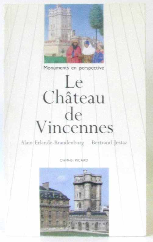
Erlande-Brandenburg - Jestaz
Le château de Vincennes
Picard 1989 115 pages in8. 1989. Broché. 115 pages. nombreuses illustrations in et hors texte noir et blanc et en couleurs
Riferimento per il libraio : 232343
|
|
|
Erlebach E. U. Ihlefeld und K. Zehner:
Psychologie F�r Lehrer Und Erzieher.
Volk und Wissen Berlin 1972. Volk und Wissen Berlin, 1972. unknown
Riferimento per il libraio : 17630
|
|
|
Erlenkotter und Reher:
Standardsoftware Benutzeroberfl�che MS Windows eine Strukturierte Einf�hrung
Rowohlt TB-V. Rnb. Reinbeck Hamburg 1991. Rowohlt TB-V., Rnb. Reinbeck, Hamburg, 1991. unknown
Riferimento per il libraio : 137796 ISBN : 3499181452 9783499181450
|
|
|
Erlenkotter und Reher:
Standardsoftware Benutzeroberfl�che MS-Windows - eine Strukturierte Einf�hrung
Rowohlt TB-V. Rnb. Reinbeck Hamburg 1991. Rowohlt TB-V., Rnb. Reinbeck, Hamburg, 1991. unknown
Riferimento per il libraio : 97631 ISBN : 3499181452 9783499181450
|
|
|
Erlewein Eugenie:
Hauswirtschaftslehre der Neuzeit Wegweiser zur Ausbildung und Weiterbildung f�r das gesamte Wirken und Schaffen im Deutschen Haushalt 1. Teil 1. Band 1. Teil 2. Band und 2. Teil = 3. B�nde
Verlag Peter & Co. M�nchen 1940. Verlag Peter & Co., M�nchen, 1940. unknown
Riferimento per il libraio : 200519
|
|
|
Erlinghagen Karl:
Katholisches Bildungsdefizit in Deutschland
Herder GmbH & Co KG Verlag Freiburg 1965. Herder GmbH & Co, KG, Verlag Freiburg, 1965. unknown
Riferimento per il libraio : 133678
|
|
|
Ermisse Gérard, Le Tréguilly Philippe
Archives Nationales - Guide du lecteur
Archives Nationales. 1993. In-8. Broché. Etat d'usage, Couv. partiel. décollorée, Dos satisfaisant, Intérieur frais. 77 pages. Quelques photos en couleurs hors texte.. . . . Classification Dewey : 53-Guide
Riferimento per il libraio : RO80253643

|
|
|
ERMACORA CHINO
GUIDA DI UDINE.
16°, PERCALLINA VERDE CON LOGO EDITORIALE E TITOLO IN ORO AL PIATTO, RISGUARDI CON LOGO EDITORIALE, PG. 305, TRA LE PAGINE DA 121 A 124 SI SEGNALA UNA MANCANZA AL BORDO BIANCO INFERIORE, NUMEROSE FOTO B.N. N.T. (ANCHE A PIENA PG.) E PUBBLICITÀ, A FINE VOLUME PIANTA RIPIEGATA DELLA CITTÀ (CM. 32X48 APERTA) CON LEGENDA IN ALTO A DESTRA E FASCIO A SINISTRA, DATA E FIRMA DI PROPRIETÀ ALL'OCCHIETTO, PUBBLICATA SOTTO GLI AUSPICI DEL CONSIGLIO PROV. DELL'ECONOMIA CORPORATIVA, BUONO STATO. PRIMA EDIZIONE.
|
|
|
ERMACORA CHINO
IL FRIULI (UDINE E GORIZIA). ITINERARI E SOSTE - 1935
In 8o, pp. 225, br., numerosissime fotografie n. t. Cop. di Cisari. Seconda edizione a cura dell'Unione Fascista dei Commercianti di Udine. Presentazione di Enrico Broili. Ottimo (2560/ FRIULI - GUIDE)
|
|
|
ERMACORA CHINO
IL FRIULI (UDINE E GORIZIA).ITINERARI E SOSTE (CON LUNGA DEDICA AUTOGRAFA ERMACORA) - 1938
In 8o, pp. 239, br., numerosissime fotografie n.t. Terza edizione. Con lunga dedica autogra autore a Viscardo Montanari. Ottimo. Altra copia senza dedica autografa euro 25 (2561/ FRIULI - GUIDE - UDINE - GORIZIA)
|
|
|
Ermando Bruno
Il libro del Gatto
Brossura vintage, copertina segnata da lievi mende alle cuffie, al piatto anteriore piccolo strappo trasmesso all'occhietto, leggero attrito ai piatti e dorso, pigmento lievemente ingiallito appesantito da ombre di polvere e impronte di umido, consunto da sfregamento il patinato, prefaz. F. Fiorone, introduz. E. Bruno, testo impreziosito da illustrazioni, fogli in ottimo stato ossidati non uniformemente, denso pulviscolo ai tagli. N. pag. 254. USATO

|
|
|
Ermani Paolo; Pignatta Valerio
Pensare come le montagne. Manuale teorico-pratico di decrescita per salvare il pianeta cambiando in meglio la propria vita
br. Questo manuale teorico-pratico è diviso in due parti; la prima è una ricca analisi della realtà italiana e mondiale, che si sofferma su temi fondamentali come ambiente, salute, alimentazione, potere, tecnologia. Si tratta di tematiche affrontate anche attraverso le riflessioni dei maggiori pensatori ecologisti contemporanei, riformulate però sulla base delle esperienze concrete dei due autori, da decenni impegnati nei movimenti ambientalisti. La seconda parte del volume illustra delle alternative concrete ai modelli di vita dominanti. L'alimentazione biologica e vegetariana, le medicine non convenzionali, le energie rinnovabili, la riduzione dei consumi e la sobrietà, la cooperazione solidaristica, l'autoproduzione, il recupero della comunità, il cohousing, l'ecovicinato sono solo alcuni esempi di come provare a uscire dalla crisi ambientale e sociale attuale. Un volume che unisce riflessione e azione, che si basa sull'idea del cambiamento dal basso, sulla gioia e sulla speranza che infondono pratiche già ben avviate. Prefazione di Simone Perotti.

|
|
|
Ermanno Heeren
Manuale storico del sistema politico degli stati d'Europa e delle loro colonie dalla sua fondazione sino ai nostri tempi
Prima versione italiana sulla quinta edizione originale tedesca del prof. Giuseppe Parola. Brossura in cartoncino particolarmente segnata dal tempo, con strappi alle cerniere e priva quasi del tutto del dorso, con usura ai margini e mancanza al margine inferiore dalla copertina fino alla n. 32 e con alcuni aloni sparsi. Pagine brunite, con tagli irregolari, legatura molto allentata o quasi sciolta in più parti, con ampio margine ed alcune rare sottolineature a pastello colorato. Numero pagine 213. USATO

|
|
|
Ermanno Libenzi
Il Piccolo codice della strada
Manuale di educazione stradale per ragazzi dagli 8 agli 80 anni. Volume privo di coperta, numero 5 nella collana Piccole strenne. Risguardi illustrati, aloni di umidità presenti ai fogli. Pagine fruibili, riccamente illustrate con oltre 200 disegni di Oppio, dentro al testo in bianco e nero. Numero pagine 198 USATO

|
|
|
Ermi Guides
Guide of Europe
Wurzburg: Conrad Trilltsch 1936. Book. Very Good. Hardcover. 18 pamphlets NF Austria Czech Denmark Germany 11 Hungaria Italy Luxembourg and Switzerland photos graphic art ads of the period basic data 1936 Olympics in Munich shown comes in original wraparound folder rare. Conrad Trilltsch Hardcover
Riferimento per il libraio : 98514
|
|
|
Erminia Vescovi
Come presentarmi in società Galateo moderno della vita civile
Brossura in cartoncino rigido, dalla copertina muta. Buono lo stato di conservazione, pagine perfettamente tenute, velate da tonalità seppia come i tagli, con XVII ( 17 ) tavole fuori testo di disegni eseguiti dal pittore Gastone Muller. Numero pagine 374. USATO

|
|
|
Erminio Mascherpa
Locomotive trifasi A comando multiplo
Spillato con copertina flessibile lucida illustrata su ambedue i piatti, appena intaccata ai margini. Timbro omaggio per recensione al frontespizio. Stato di conservazione buona con pagine avorio, corredate da disegni e fotografie in bianco e nero con didascalie nel testo. Numero pagine 63. USATO

|
|
|
Ernst Philipp
Asthma and other allergies - an explanation for the layman
A.H. & A.W. Reed 1970 in12. 1970. Cartonné.
Riferimento per il libraio : 100069269

|
|
|
Ernest Mamboury
Istanbul touristique - édition française mise à jour à fin mars 1951
Cituri Biraderler Basimevi / Istanbul 1951 in12. 1951. Cartonné. iconographie en noir et blanc cartes en noir et blanc
Riferimento per il libraio : 100096502
|
|
|
Erna Horn, A. Lodispoto
Dieta e cucina Il medico parla e la donna cucina
Legatura editoriale in cofanetto mezza tela non danneggiato ma segnato da ombre e velature di polvere, illustrato in entrambi i lati, ottimo lo stato della sovraccoperta illustrata con solo un piccolo strappetto al dorso, titolo oro al piatto anteriore e al dorso della copertina texture tela rossa, disegni alle carte di guardia e nel testo a cura di Vittorio Antinori, pagine allo stato di nuovo corredate da 32 illustrazioni a colori su tavole fuori testo. Prefazione di Alberto Lodispoto, traduzione dal tedesco a cura di Anna Venturini e Luciano Rasny. N. pag. 549. USATO

|
|
|
ERNANI
Dramma lirico i quattro parti di F. M. Piave. Musica di G. Verdi
ERNANI Dramma lirico i quattro parti di F. M. Piave. Musica di G. Verdi. Milano, Ricordi (1911), In 16°, bross. arancio, pp. 36. Timbro a secco 11/11. Timbo a inchiostro alla cop. e alle prime 2 pagine Buono (Good) . <br> <br> <br>
|
|
|
ERNANI
Dramma lirico in quattro parti di F. M. Piave. Musica di G. Verdi
ERNANI Dramma lirico in quattro parti di F. M. Piave. Musica di G. Verdi. Milano, Ricordi (1900), In 16°, bross. beige, pp. 36. Timbro secco 3/1900 Buono (Good) . <br> <br> <br>
|
|
|
ERNANI
Dramma lirico in quattro parti di F.M. Piave. Musica di G. Verdi
ERNANI Dramma lirico in quattro parti di F.M. Piave. Musica di G. Verdi. , 1928, Pp. 32 Buono (Good) . <br> <br> <br>
|
|
|
ERNANI
Musica di G. Verdi
ERNANI Musica di G. Verdi. , , Buono (Good) . <br> <br> <br>
|
|
|
ERNANI
Musica di G. Verdi
ERNANI Musica di G. Verdi. , 1913, Buono (Good) . <br> <br> <br>
|
|
|
 Ricevere i risultati per e-mail
 Scaricare i risultati in PDF
 RSS feed


