|
Buvards - n°Ancel
(Ref.: Ref98932)
Riferimento per il libraio : 9782845235881
|
|
|
Buvards - n°Boussac (ballons)
(Ref.: Ref98932)
Riferimento per il libraio : 9782845235869
|
|
|
Buvards - n°Boussac (enfants)
(Ref.: Ref98932)
Riferimento per il libraio : 9782845235870
|
|
|
Buvards - n°Cémoi
(Ref.: Ref98932)
Riferimento per il libraio : 9782845235873
|
|
|
Buvards - n°Evian
(Ref.: Ref98932)
Riferimento per il libraio : 9782845235878
|
|
|
Buvards - n°Izarra
(Ref.: Ref98932)
Riferimento per il libraio : 9782845235875
|
|
|
Buvards - n°Léonce Guyon
(Ref.: Ref98932)
Riferimento per il libraio : 9782845235880
|
|
|
Buvards - n°Marcel Avez
(Ref.: Ref98932)
Riferimento per il libraio : 9782845235866
|
|
|
Buvards - n°Menier
(Ref.: Ref98932)
Riferimento per il libraio : 9782845235871
|
|
|
Buvards - n°Novemail
(Ref.: Ref98932)
Riferimento per il libraio : 9782845235868
|
|
|
Buvards - n°Poulain
(Ref.: Ref98932)
Riferimento per il libraio : 9782845235874
|
|
|
Buvards - n°Saphir
(Ref.: Ref98932)
Riferimento per il libraio : 9782845235872
|
|
|
Buvards - n°Teinture idéale
(Ref.: Ref98932)
Riferimento per il libraio : 9782845235876
|
|
|
Buvards - n°Unicoop
(Ref.: Ref98932)
Riferimento per il libraio : 9782845235879
|
|
|
Buvards - n°Util
(Ref.: Ref98932)
Riferimento per il libraio : 9782845235877
|
|
|
California points of interest and touring map
1 map in 6 segments : color ; on sheets 23 x 41 cm, folded to 23 x 10 cm Prepared exclusively for Standard Oil Company of California. || Map Info: Scale [ca. 1:1,267,200].; (W 124∞22í--W 114∞07í/N 42∞00í--N 32∞32í). || Cartgraph Code: Category of scale: a Constant ratio linear horizontal scale: 1267200 West longitude: W1242200 East longitude: W1140700 North latitude: N0420000 South latitude: N0323200 || Relief shown by shading and spot heights./ Panel title./ Also shows roads, trails, state and national parks and reserves, airports, drainage, etc./ Collated in booklet format (19 p.)./ Ancillary maps: Simplified touring map of California (p. 1-2) -- Road map of United States (p. 17-18) -- San Francisco and vicinity (p. 19). Scale [ca. 1:234,430] 1 in. = approx. 3.7 miles -- Los Angeles and vicinity (p. 19). Scale [ca. 1:304,130]. 1 in. = approx. 4.8 miles./ Includes index, mileage charts, text and ill./ "606-S-AA-1." || Roads -- California -- Maps. Tourist maps.
|
|
|
CAMP de Mr le duc d'Harcourt. près de Deckendorf en Bavière. Levé exactement sur les lieux par N.N
A Paris, chez le Sr Le Rouge, 1742 75 x 51,
Riferimento per il libraio : 168213
|
|
|
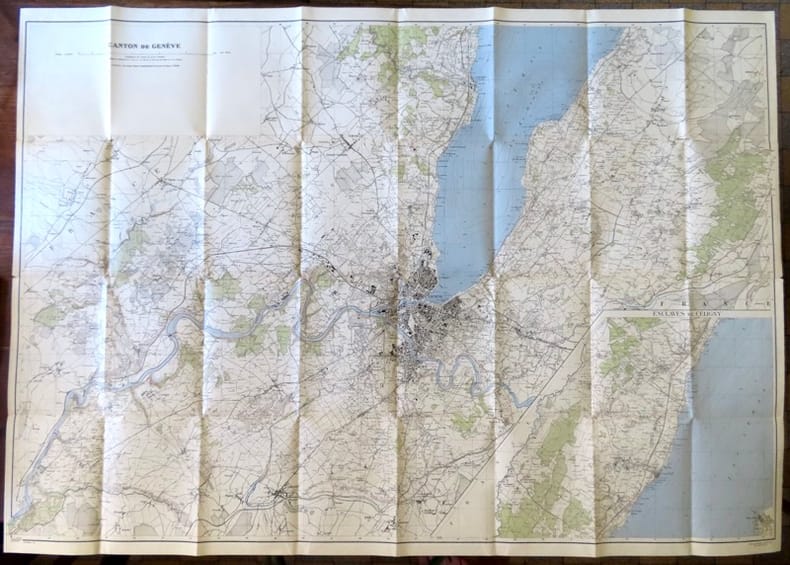
Canton de Genève, avec enclaves de Céligny.
Berne, Service topographique fédéral, 1946. Carte au 1:25 000, au format ouvert de 111 x 79 cm. Tampon au premier plat.
Riferimento per il libraio : 18657
|
|
|
Carly's Radfahr-Automobil- und Touristenkarte mit Angabe der Entfernungen in Kilometern nebst Plan des Ohlsdorfer Friedhofes, Theater-Plänen etc. etc. [Außentitel: Carly's Radfahr-Automobil-Touristenkarte m. Angabe der Entfernungen in Kilometern].
Hamburg, O. und R. Enoch, [ca. 1905]. Farbiger, lithograph. Faltplan (verso s/w Druck). Blattmaß: 62 x 70,5 cm, Kartenmaß 60 x,69 cm, gefaltet 16 x 9,5 cm. OKart.
Riferimento per il libraio : 88148
|
|
|
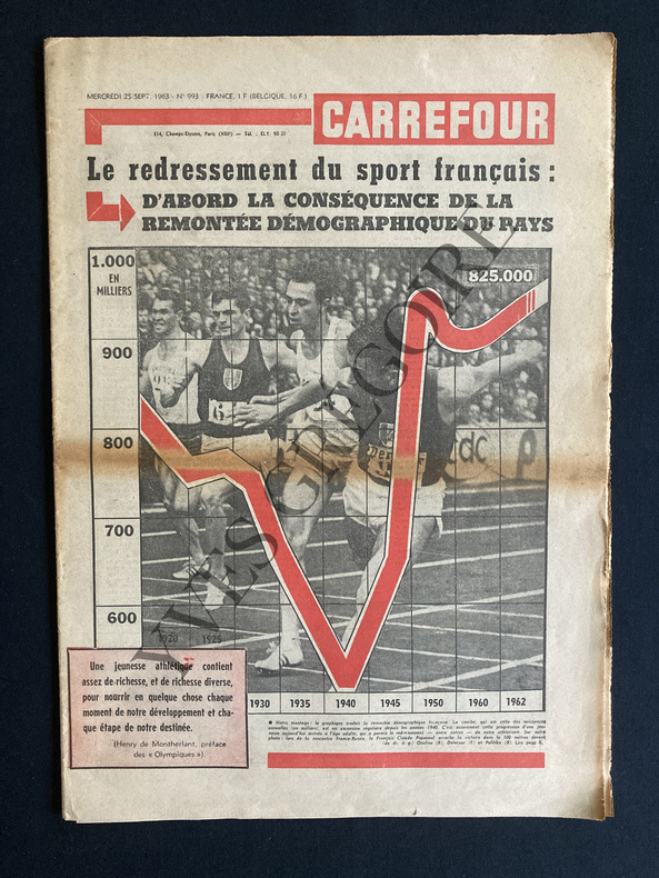
CARREFOUR-N°993-25 SEPTEMBRE 1963
24 PAGES-30,5 CM X 43 CM-LE POUVOIR D'UN SEUL, PAR ANDRE STIBIO, DE GAULLE-ARTHUR CONTE A VU ET ECOUTE L'ASIE A L'HEURE CHINOISE, 1P, UNE "GRANDE POLITIQUE CHINOISE" DE LA FRANCE?, PAR MAURICE NEGRE, 1P-APRES LES SPOLIATIONS QUI FRAPPENT LES FRANCAIS D'ALGERIE IL NE SUFFIT PAS DE PROTESTER IL FAUT REPARER, "EVIAN N'EST PAS LE CORAN", 1 PAGE-VICTIME DE L'ABANDON DE L'AFRIQUE DU NORD MARSEILLE N'EST PLUS LE PREMIER PORT FRANCAIS POUR LE TRAFIC PASSAGERS, 1P, PHOTO-POUR L'AMNISTIE I ANNIVERSAIRES PAR RENE CATHALA, 1P, SI L'ON REPARLAIT DE L'OAS.-L'ONU A 18 ANS ELLE A BIEN MAL TOURNE, 1P PAR BERNARD CABANES, DESSIN DE MOISAN-ON NE PEUT PAS (ENCORE) DECROCHER LA LUNE, 2P, 2 PHOTOS, FRANCE 1-APRES LE CRI D'ALARME DES HYGIENISTES ET DES MEDECINS: FAUT-IL SUIVRE LE BOEUF.ATTENDRI?, 2 PAGES-LA TROISIEME BIENNALE DE PARIS-LES CARTES A JOUER, 1 PAGE, 5 ILL-EN DERNIERE PAGE DESSIN D'ANGE MICHEL "LA LUNE PAR DESSUS LE MUR", MUR DE BERLIN
Riferimento per il libraio : ABE-1635033102530
|
|
|
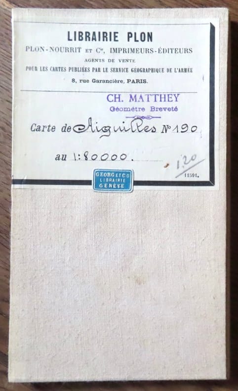
Carte d'Aiguilles.
Paris, Librairie Plon / Plon, Nourrit et Cie. Carte au 1/80'000, entoilée, au format ouvert de 46 x 32 cm., vignette de la Librairie plon contrecollée au premier plat. Tampon de géomètre.
Riferimento per il libraio : 18273
|
|
|
Carte de l'Egypte appellée en Arabe Barr Masr c'est à dire Pays de Masr. Kupferstich.
[Paris, 1787]. 32,5 x 26 cm.
Riferimento per il libraio : 81418

|
|
|
Carte de l'Empire Ottoman pour mettre a la fin de chaque volume de l'Histoire des Turcs. Kupferstichkarte.
La Haye [Den Haag], T. Johnson, 1709. 33,5 x 44,5 cm. Unter Passepartout.
Riferimento per il libraio : 81229

|
|
|
Carte de la ligne du Mont Cenis. Ligne Londres-Paris-Rome. Echelle 1:120000,
Zurih, Orell Füssli & Co. s.d. , in-4to, 16 p. + carte géographique dessinée sur papier par G. Maggini d'après les cartes des Etats majors français et italiens, brochure originale illustrée avec dos toilé (petite perte au dos),
Riferimento per il libraio : 76774aaf
|
|
|
Carte de Pontarlier.
Paris, Librairie Plon / Plon, Nourrit et Cie. Carte au 1/80'000, entoilée, au format ouvert de 49 x 59 cm., vignette de la Librairie plon contrecollée au premier plat.
Riferimento per il libraio : 18272

|
|
|
CARTE DE ROYAUME DE FRANCE Divisee En 86 Departmens Comprenant Les Chefs lieux Les Sous Prefectures et Les Chefs Lieux De Cantons
Paris - 21 Quai Voltaire: Rosselin 1830. A fine map hand-coloured in outline folding into original marbled paper boards with title label to the front board. Boards rubbed conrners worn. The map measures 74 x 55cm and is in very good condition with the paper bright. A very good to fine copy of this rare map. Map. Fine. Rosselin Hardcover
Riferimento per il libraio : 009582

|
|
|
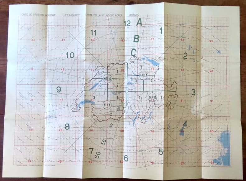
Carte de situation aerienne / Luftlagekarte / Carta deall situazione aerea.
Berne, Service topographique fédéral / Eidg. Landestopographie / Servizio topografico federale, 1963. Carte au 1:1.000.000, au format ouvert de 78 x 57 cm. En belle condition
Riferimento per il libraio : 18438
|
|
|
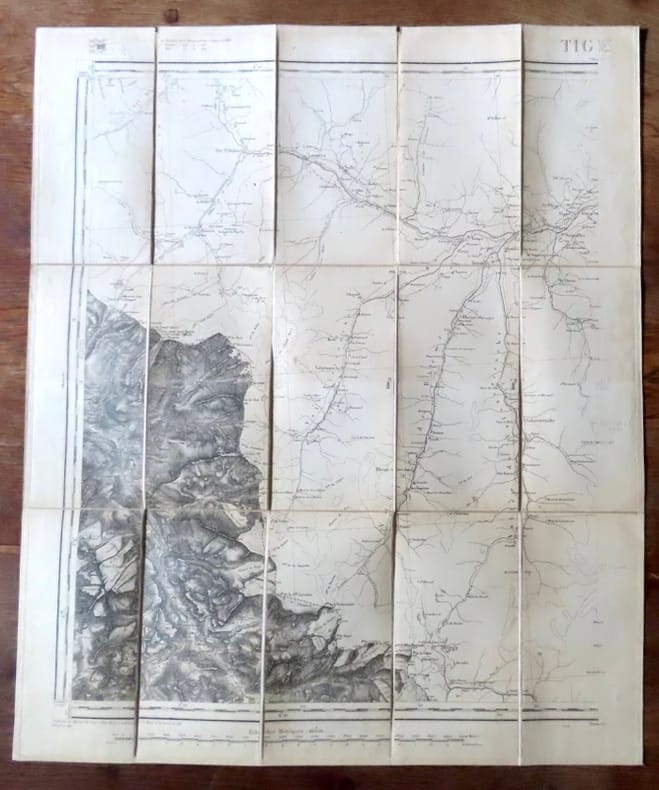
Carte de Tignes.
Paris, Librairie Plon / Plon, Nourrit et Cie. Carte au 1/80'000, entoilée, au format ouvert de 49 x 59 cm., vignette de la Librairie plon contrecollée au premier plat. Tampon de géomètre, un autre de libraire. En belle condition.
Riferimento per il libraio : 18276
|
|
|
Carte du fleuve Niger depuis le village de Pot d'Or jausu'au Village de Condel. Kupferstich.
[Amsterdam / Paris, Maradan, 1789]. Bildgröße 8 x 13,5 cm, Blattgröße 10 x 15 cm. Unter Passepartout.
Riferimento per il libraio : 81634

|
|
|
Carte du fleuve Niger depuis son embouchure jusqu'au village de Pot d'Or. Kupferstich.
[Amsterdam / Paris, Maradan, 1789]. Bildgröße 8,5 x 14 cm, Blattgröße 10,5 x 17 cm. Unter Passepartout.
Riferimento per il libraio : 81620

|
|
|
CARTE DU MASSIF DU MONT-BLANC. Region Nord-ouest - Paris 1946 - Mapa
Paris, Edit. SCAP, 1946. Mapa topográfico excursionista. Escala 1: 50.000. En français. Muy buen ejemplar.
|
|
|
Carte du monde, par Hérisson format 24x19cm, bel état, vers 1820
format 24x19cm, bel état, vers 1820 ref/classeur 5
Riferimento per il libraio : CZC-12717

|
|
|
Carte du monde, par Hérisson format 24x19cm, bel état, vers 1820
format 24x19cm, bel état, vers 1820 ref/classeur 5
Riferimento per il libraio : CZC-12717
|
|
|
Carte du monde, par Hérisson format 35x17cm, bel état, vers 1820
format 35x17cm, bel état, vers 1820 ref/classeur 5
Riferimento per il libraio : CZC-12716

|
|
|
Carte du monde, par Hérisson format 35x17cm, bel état, vers 1820
format 35x17cm, bel état, vers 1820 ref/classeur 5
Riferimento per il libraio : CZC-12716
|
|
|
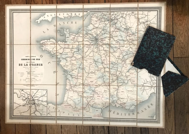
Carte générale des Chemins de Fer et des Voies navigables de la France.
Paris, Chaix, (vers 1860). 86 x 64,5 cm au cadre. Entoilée et repliée sous un étui-chemise de papier cuve.
Riferimento per il libraio : 8170
|
|
|
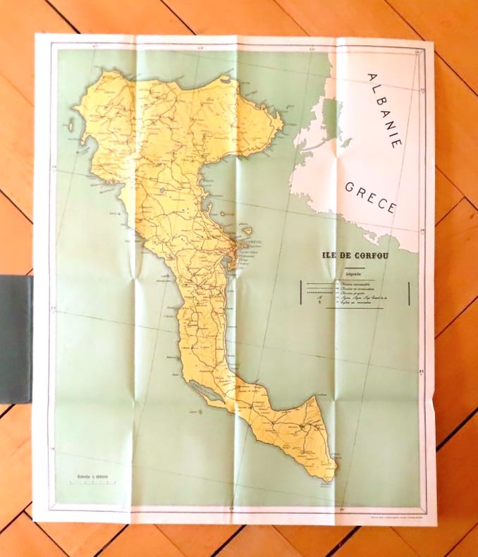
Carte géographique de l'île de Corfou.
Corfu, The greek graphic arts ltd / G. Aspiotis Brothers, sans date. Carte au format 53 x 64, sous couverture imprimée. En belle condition.
Riferimento per il libraio : 19035
|
|
|
Carte Michelin 204: Allemagne (Frankfurt)
1cm to 2km. eng
|
|
|
Carte Michelin 205: Allemagne (Strasbourg)
1cm to 2km. eng
|
|
|
CARTE MICHELIN de la FRANCE ( En 47 Feuilles ) N° 37 / GAP - CONI
Paris Librairie Charles Delagrave, sans date (vers 1910) 1 carte routière ancienne, imprimée en couleurs, sous couverture illustrée. Feuille: GAP-CONI, de format : 42,5 x 101 cms, de la France en 47 feuilles. Carte au 200.000e. Bel exemplaire ( Photographies sur demande / We can send pictures of this print on simple request )
Riferimento per il libraio : 40786
|
|
|
Carte nazionale d. Svizzera / Landeskarte d. Schweiz 1: 100 000. Verkauf pro Karte: Blatt: 32 Beromünster 1970 / 33 Toggenburg 1973 / 38 Panixerpass 1973 / 42 Oberwallis 1971 / 43 Sopa Ceneri 1972 / 48 Sotto Ceneri 1967.
Wabern, Eidg. Landestopogr., 1967 - 1973, 20x14 gefaltet, Unschlag Rotaufdruck Verkauf Pro Karte.
Riferimento per il libraio : 136254aaf
|
|
|
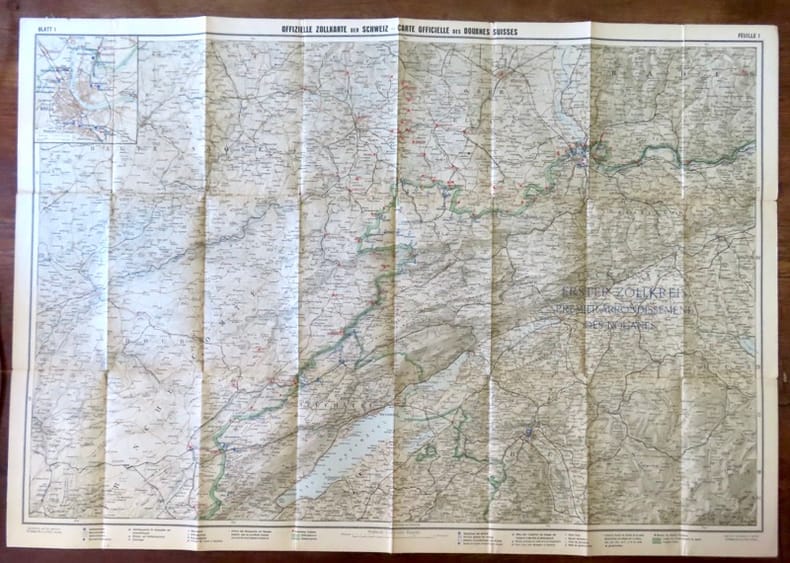
Carte officielle des douanes suisses, feuille 1 / Offizielle Zollkarte der Schweiz, Blatt 1.
Berne, Département des douanes suisses / Zollderpartement - Kümmerli & Frey, sans date. Carte entoilée au 1:200.000, au format ouvert de 93 x 65 cm.
Riferimento per il libraio : 18439
|
|
|
carte postale publicitaire Soulié & Macé
Carte postale ancienne | Etat : Bon état (Ref.: ref97086)
Riferimento per il libraio : 9782845227149
|
|
|
Carte postale publicitaire Soulié & Macé
Carte postale ancienne | Etat : Bon état (Ref.: ref97087)
Riferimento per il libraio : 9782845227150
|
|
|
Carte postale publicitaire Soulié & Macé
Carte postale ancienne | Etat : Bon état (Ref.: ref97088)
Riferimento per il libraio : 9782845227151
|
|
|
Carte postale publicitaire Soulié & Macé
Carte postale ancienne | Etat : Bon état (Ref.: ref97089)
Riferimento per il libraio : 9782845227152
|
|
|
Carte postale publicitaire Soulié & Macé
Carte postale ancienne | Etat : Bon état (Ref.: ref97090)
Riferimento per il libraio : 9782845227153
|
|
|
CARTE ROUTIERE 722 FRANCE RECTO-VERSO 2009
MICHELIN 2009 16 pages 10 8x0 2x23 2cm. 2009. map. 16 pages.
Riferimento per il libraio : 500179372

|
|
|
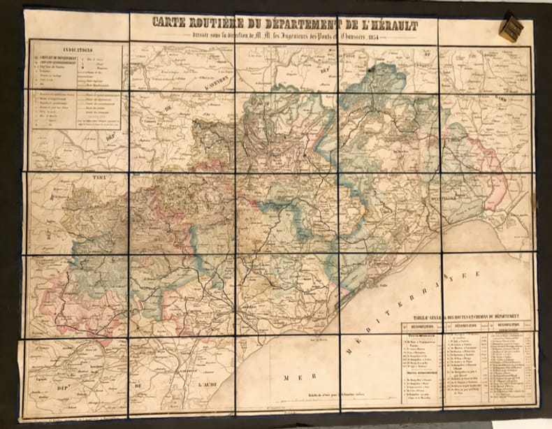
Carte routière du département de l'Hérault. Dressée sous la direction de MM. les Ingénieurs des Ponts & Chaussées.
Montpellier, Boehm, 1854. 72 x 56 cm à la feuille. Épreuve morcelée et marouflée sur une toile bleu nuit, repliée au format in-12.
Riferimento per il libraio : 31732
|
|
|
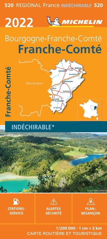
Carte Régionale Franche-Comté 2022
MICHELIN 2022 11 2x25x2 3cm. 2022. map.
Riferimento per il libraio : 500111091
|
|
 Ricevere i risultati per e-mail
 Scaricare i risultati in PDF
 RSS feed


