|
|
|
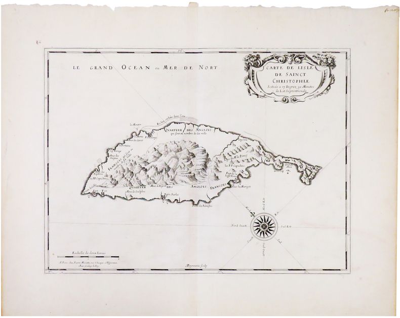
SANSON d'ABBEVILLE (Nicolas).
[SAINT KITTS] Carte de lisle de Sainct Christophle.
Paris, Pierre Mariette, [1670]. 308 x 424 mm.
Référence libraire : LBW-606
|
|
|
SANSON d'ABBEVILLE (Nicolas).
[SARLAT] Petrocorii. Évesché de Sarlat. Partie méridionale de l'eslection de Périgord.
Paris, Pierre Mariette, 1676. 327 x 475 mm.
Référence libraire : LBW-7221

|
|
|
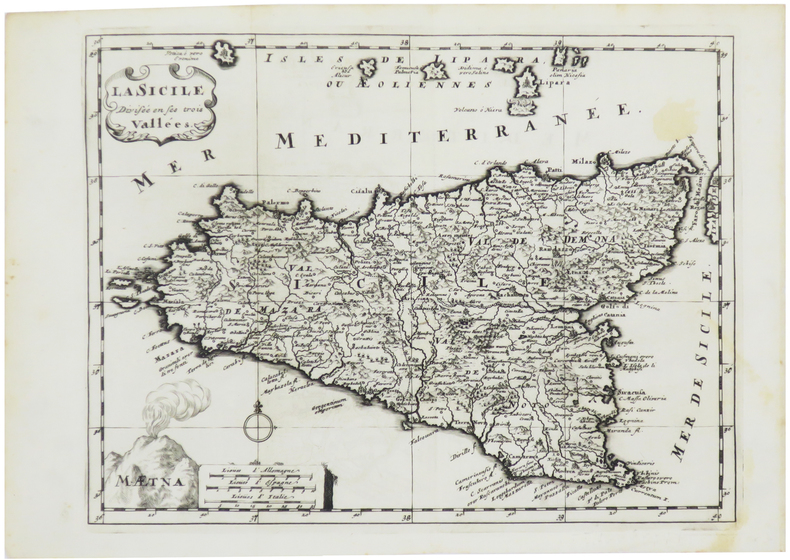
SANSON d'ABBEVILLE (Nicolas).
[SICILE] La Sicile divisée en ses trois vallées.
[1700]. 202 x 266 mm.
Référence libraire : LBW-5427
|
|
|
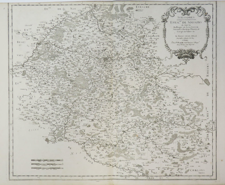
SANSON d'ABBEVILLE (Nicolas).
[SOISSONS] Suessones. Evesc.hé de Soissons où sont les balliages et eslections de Soissons, Chasteau Thierry et Crespy en Valois &c.
Paris, P. Mariette, 1656. 415 x 485 mm.
Référence libraire : LBW-3411
|
|
|
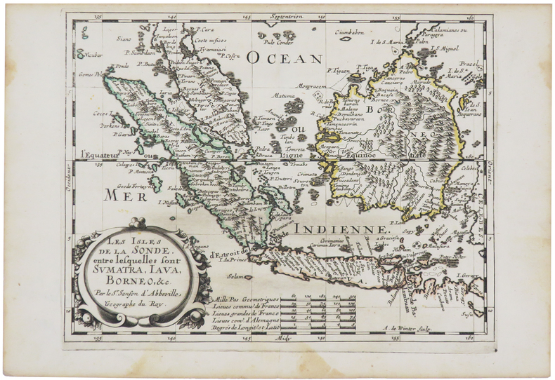
SANSON d'ABBEVILLE (Nicolas).
[SUMATRA/JAVA/BORNÉO] Les isles de la Sonde, entre lesquelles sont Sumatra, Java, Bornéo, &c.
[circa 1660]. 195 x 247 mm.
Référence libraire : LBW-5437
|
|
|
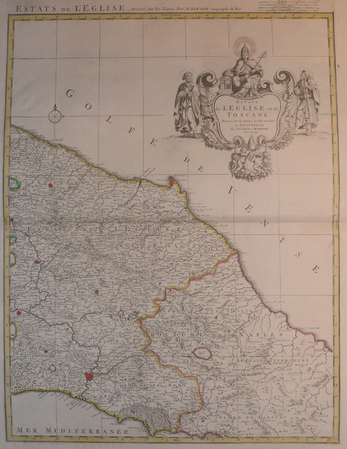
SANSON d'ABBEVILLE (Nicolas) & COVENS et MORTIER.
[TOSCANE/ETATS DE L'EGLISE] Estats de l'Eglise et de Toscane.
Amsterdam, Covens et Mortier, [circa 1710]. 580 x 445 mm.
Référence libraire : LBW04176
|
|
|
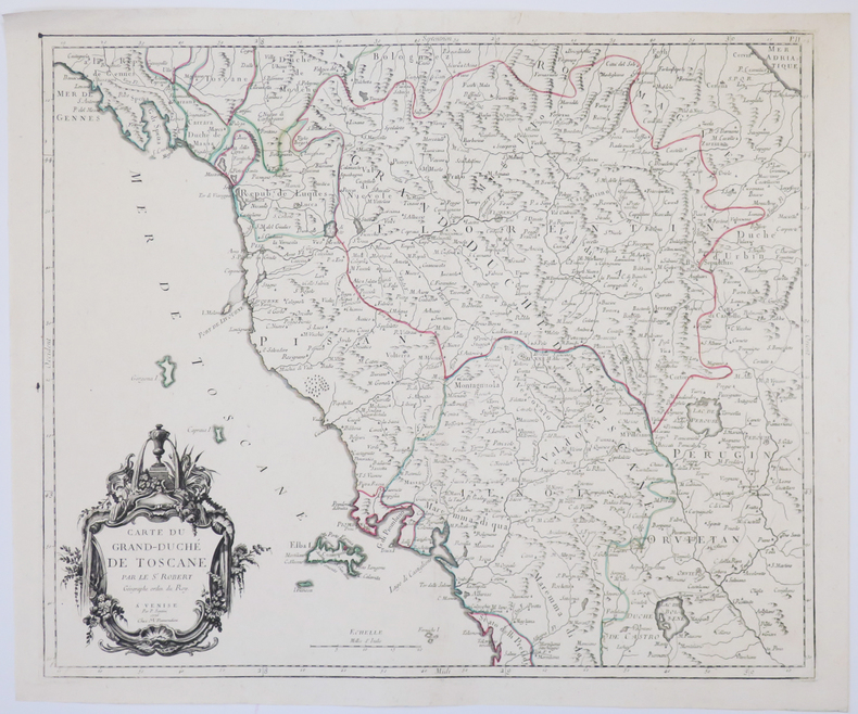
SANTINI (Paolo).
[TOSCANE] Carte du Grand-Duché de Toscane.
Venise, M. Remondini, 1776. 470 x 564 mm.
Référence libraire : LBW-4927
|
|
|
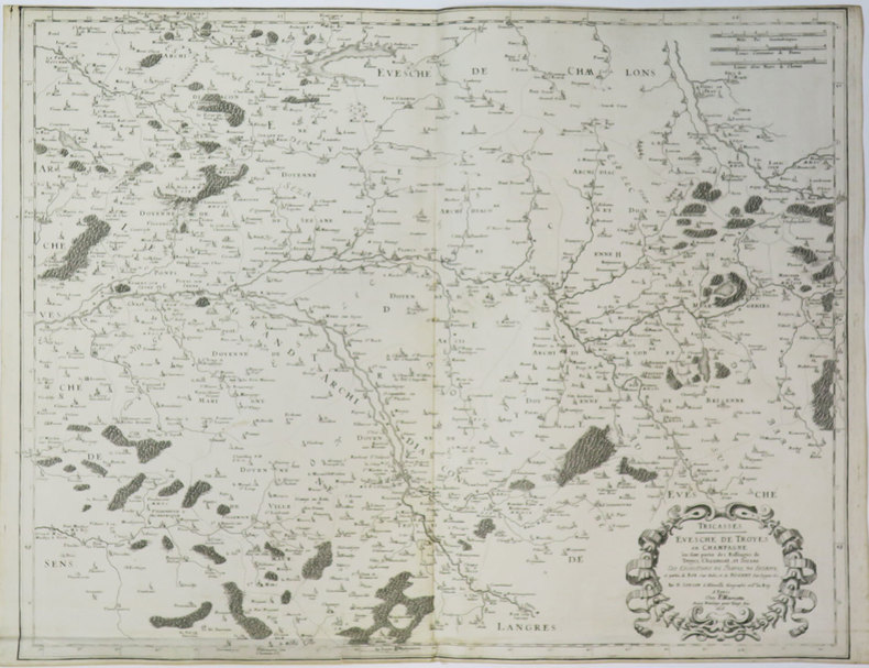
SANSON d'ABBEVILLE (Nicolas).
[TROYES] Tricasses. Evesché de Troyes en Champagne où sont partie des balliages de Troyes, Chaumont, et Sézane.
Paris, P. Mariette, 1656. 430 x 544 mm.
Référence libraire : LBW-3638
|
|
|
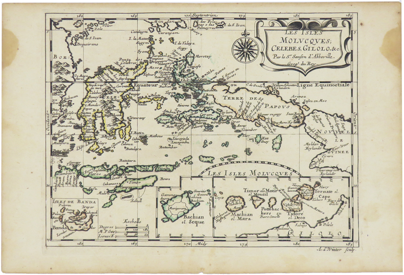
SANSON d'ABBEVILLE (Nicolas).
[ÎLES MOLUQUES] Les isles Molucques, Célèbes, Gilolo, &c.
[Paris, circa 1680]. 187 x 245 mm.
Référence libraire : LBW-5478
|
|
|
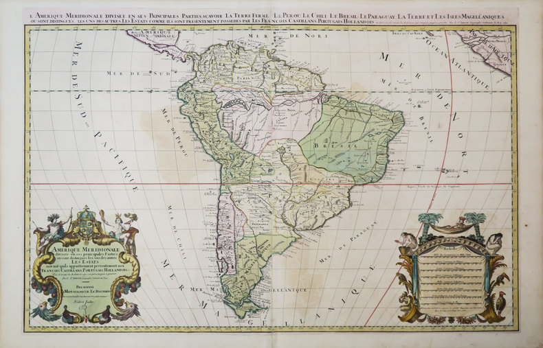
SANSON d'ABBEVILLE (Nicolas) & JAILLOT (Hubert).
Amérique méridionale divisée en ses principales parties où sont distingués les uns des autres les estats suivant qu'ils appartiennent présentement aux François, Castillans, Portugais, Hollandois, &c.
Paris, H. Jaillot, 1691. En deux feuilles jointes de 573 x 884 mm.
Référence libraire : LBW-3673
|
|
|
SANSON d'ABBEVILLE (Nicolas);
Audience de Guatimala.
1683 182 x 276 mm.
Référence libraire : LBW-697

|
|
|
SANSON d'ABBEVILLE.
Baillage de Mascon en Bourgogne, Evesché de Mascon.
1659 Limites aquarellées. 1 carte gravée sur cuivre, 43 x 53 cms. P. Sanson 1659
Référence libraire : 12214
|
|
|
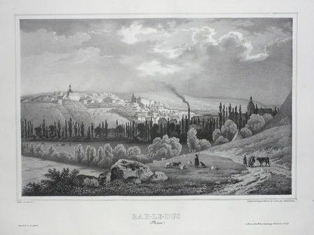
SANDMANN;
BAR-LE-DUC (Meuse).
Paris Benard circa 1850 222 x 295 mm.
Référence libraire : LBW03d58
|
|
|
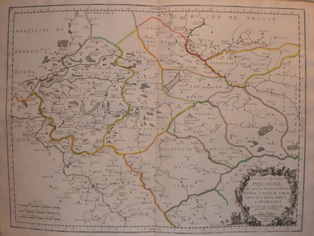
SANSON d'ABBEVILLE (Nicolas);
Basse ou Grande Pologne où sont les palatinats de Posna, Calisch, Sirad, Lencici, Rava, Brest, et Inowlocz.
Paris chez l'autheur 1703 417 x 560 mm.
Référence libraire : LBW02524
|
|
|
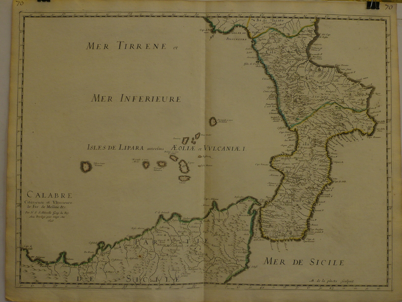
SANSON d'ABBEVILLE (Nicolas);
Calabre citérieure et ultérieure, le far de Messine &c.
1648 409 x 558 mm.
Référence libraire : LBW-969
|
|
|
sans auteur
CARTE DEPARTEMENTALE DE LOIRE-ATLANTIQUE
1970 carte papier en couleurs (map in paper in colours) - repliée sous une chemise orange éditeur in-octavo (folding under editor jacket), couverture imprimée (cover printed), dimensions (size in Inches) : 75,50 centimètres de largeur (width : 29,72) sur 56 de hauteur (height :22,04 ), sans date (les années 1950) à Paris Editions Géographiques André Lesot - Imprimerie Gaillac-Monrocq et Compagnie,
Référence libraire : 9208
|
|
|
SANSON Nicolas
Carte "MAPPE-MONDE OU CARTE GENERALE DU GLOBE TERRESTRE , Représentée en deux Plan-Hémisphères, Reveüe et changée en plusieurs endroits suivant les Relations les plus récentes"par le Sieur SANSON Géographe Ordinaire de sa Majesté
Amsterdam Chatelain 1745 une carte ancienne gravée sur cuivre (Copper etching) en noir . Format : 16 x 19,1 cm, Échelle au1:200,000,000ème, pli central vertical normal venant d'un atlas( horizontal centerfold), avec note dans la marge en haut à droite : Tome I Page I, pour "l'introduction à l'histoire générale et politique de l'univers, Ou l'on voit l'Origine, les Révolutions, l'Etat présent, & les Intérêts des Souverains" ; Commencée par Mr. le Baron de Pufendorff ; complétée et continuée jusqu'à 1745 par Mr. Bruzen de la Martinière, 8 volumes in-12, 1745 à Amsterdam chez Zacharie Chatelain Editeur,
Référence libraire : 18847
|
|
|
SANSON Nicolas
CARTE "LE GLOBE CELESTE, ou l'on voit, 1022 étoiles en 48 constellations, 12 dans le zodiaque et 36 hors du zodiaque, etc."
Amsterdam Chatelain 1745 une carte ancienne gravée sur cuivre (Copper etching) en noir . Format : 16 x 19,1 cm, Échelle au1:200,000,000ème, pli central vertical normal venant d'un atlas( horizontal centerfold), avec note dans la marge en haut à droite : Tome I Page I, pour "l'introduction à l'histoire générale et politique de l'univers, Ou l'on voit l'Origine, les Révolutions, l'Etat présent, & les Intérêts des Souverains" ; Commencée par Mr. le Baron de Pufendorff ; complétée et continuée jusqu'à 1745 par Mr. Bruzen de la Martinière, 8 volumes in-12, 1745 à Amsterdam chez Zacharie Chatelain Editeur,
Référence libraire : 18848
|
|
|
SANSON Nicolas
Carte "AFRIQUE" par le Sieur Sanson d'Abbeville, géographe du roy
Amsterdam Chatelain 1745 une carte ancienne gravée sur cuivre (Copper etching) en noir . Format : 17 x 19,2 cm, Échelle au1:200,000,000ème, pli central vertical normal venant d'un atlas( vertical centerfold), avec note dans la marge en haut à droite : Tome VII Page 246, pour "l'introduction à l'histoire générale et politique de l'univers, Ou l'on voit l'Origine, les Révolutions, l'Etat présent, & les Intérêts des Souverains" ; Commencée par Mr. le Baron de Pufendorff ; complétée et continuée jusqu'à 1745 par Mr. Bruzen de la Martinière, 8 volumes in-12, 1745 à Amsterdam chez Zacharie Chatelain Editeur,
Référence libraire : 18849
|
|
|
SANSON Nicolas
Carte de "SUEDE, DANEMARK, ET NORVEGE" par le Sieur Sanson d'Abbeville, géographe du roy
Amsterdam Chatelain 1745 une carte ancienne gravée sur cuivre (Copper etching) en noir . Format : 17 x 20,5 cm, Échelle au1:200,000,000ème, pli central vertical normal venant d'un atlas ( vertical centerfold), avec note dans la marge en haut à droite : Tome IV Page 267, pour "l'introduction à l'histoire générale et politique de l'univers, Ou l'on voit l'Origine, les Révolutions, l'Etat présent, & les Intérêts des Souverains" ; Commencée par Mr. le Baron de Pufendorff ; complétée et continuée jusqu'à 1745 par Mr. Bruzen de la Martinière, 8 volumes in-12, 1745 à Amsterdam chez Zacharie Chatelain Editeur,
Référence libraire : 18850
|
|
|
SANSON Nicolas
Carte "LES DIX SEPT PROVINCES DES PAYS-BAS" par le Sieur Sanson d'Abbeville, géographe du roy
Amsterdam Chatelain 1745 une carte ancienne gravée sur cuivre (Copper etching) en noir . Format : 17 x 19,5 cm, Échelle au1:200,000,000ème, pli central vertical normal venant d'un atlas ( vertical centerfold), avec note dans la marge en haut à droite : Tome IV Page 151, pour "l'introduction à l'histoire générale et politique de l'univers, Ou l'on voit l'Origine, les Révolutions, l'Etat présent, & les Intérêts des Souverains" ; Commencée par Mr. le Baron de Pufendorff ; complétée et continuée jusqu'à 1745 par Mr. Bruzen de la Martinière, 8 volumes in-12, 1745 à Amsterdam chez Zacharie Chatelain Editeur,
Référence libraire : 18851
|
|
|
SANSON Nicolas
Carte "ASIE" par le Sieur Sanson d'Abbeville, Géographe Ordinaire du Roy
Amsterdam Chatelain 1745 une carte ancienne gravée sur cuivre (Copper etching) en noir . Format : 17 x 19,5 cm, Échelle au1:200,000,000ème, pli central vertical normal venant d'un atlas ( vertical centerfold), avec note dans la marge en haut à droite : Tome VI Page 1, pour "l'introduction à l'histoire générale et politique de l'univers, Ou l'on voit l'Origine, les Révolutions, l'Etat présent, & les Intérêts des Souverains" ; Commencée par Mr. le Baron de Pufendorff ; complétée et continuée jusqu'à 1745 par Mr. Bruzen de la Martinière, 8 volumes in-12, 1745 à Amsterdam chez Zacharie Chatelain Editeur,
Référence libraire : 18853
|
|
|
SANSON Nicolas
Carte "AMERICQUE SEPTENTRIONALE" par le N. Sanson d'Abbeville, Géographe du Roy
Amsterdam Chatelain 1745 une carte ancienne gravée sur cuivre (Copper etching) en noir . Format : 17 x 19,5 cm, Échelle au1:200,000,000ème, pli central vertical normal venant d'un atla ( vertical centerfold), avec note dans la marge en haut à droite : Tome VIII Page 87, pour "l'introduction à l'histoire générale et politique de l'univers, Ou l'on voit l'Origine, les Révolutions, l'Etat présent, & les Intérêts des Souverains" ; Commencée par Mr. le Baron de Pufendorff ; complétée et continuée jusqu'à 1745 par Mr. Bruzen de la Martinière, 8 volumes in-12, 1745 à Amsterdam chez Zacharie Chatelain Editeur,
Référence libraire : 18854
|
|
|
SANSON Nicolas
Carte "AMERICQUE MERIDIONALE" par le N. Sanson d'Abbeville, Géographe du Roy
Amsterdam Chatelain 1745 une carte ancienne gravée sur cuivre (Copper etching) en noir . Format : 17 x 19,5 cm, Échelle au1:200,000,000ème, pli central vertical normal venant d'un atlas ( vertical centerfold), avec note dans la marge en haut à droite : Tome VIII Page 1, pour "l'introduction à l'histoire générale et politique de l'univers, Ou l'on voit l'Origine, les Révolutions, l'Etat présent, & les Intérêts des Souverains" ; Commencée par Mr. le Baron de Pufendorff ; complétée et continuée jusqu'à 1745 par Mr. Bruzen de la Martinière, 8 volumes in-12, 1745 à Amsterdam chez Zacharie Chatelain Editeur,
Référence libraire : 18855
|
|
|
SANSON Nicolas
Carte "ISLES BRITANNIQUES" par le N. Sanson le Fils, Géographe du Roy
Amsterdam Chatelain 1745 une carte ancienne gravée sur cuivre (Copper etching) en noir . Format : 17 x 19,5 cm, Échelle au1:200,000,000ème, pli central vertical normal venant d'un atlas ( vertical centerfold), avec note dans la marge en haut à droite : Tome IV Page 142, pour "l'introduction à l'histoire générale et politique de l'univers, Ou l'on voit l'Origine, les Révolutions, l'Etat présent, & les Intérêts des Souverains" ; Commencée par Mr. le Baron de Pufendorff ; complétée et continuée jusqu'à 1745 par Mr. Bruzen de la Martinière, 8 volumes in-12, 1745 à Amsterdam chez Zacharie Chatelain Editeur,
Référence libraire : 18856
|
|
|
SANSON Nicolas
Carte "SCANDINAVIE ou sont les Estats de DANEMARK, de SUEDE etc." par le N. Sanson le Fils, Géographe du Roy
Amsterdam Chatelain 1745 une carte ancienne gravée sur cuivre (Copper etching) en noir . Format : 17 x 19,5 cm, Échelle au1:200,000,000ème, pli central vertical normal venant d'un atlas ( vertical centerfold), avec note dans la marge en haut à droite : Tome IV Page 309, pour "l'introduction à l'histoire générale et politique de l'univers, Ou l'on voit l'Origine, les Révolutions, l'Etat présent, & les Intérêts des Souverains" ; Commencée par Mr. le Baron de Pufendorff ; complétée et continuée jusqu'à 1745 par Mr. Bruzen de la Martinière, 8 volumes in-12, 1745 à Amsterdam chez Zacharie Chatelain Editeur,
Référence libraire : 18857
|
|
|
SANSON Nicolas
Carte "LA PRUSSE" lieues d'Allemagne de 15 au degré (par N. Sanson le Fils, Géographe du Roy)
Amsterdam Chatelain 1745 une carte ancienne gravée sur cuivre (Copper etching) en noir . Format : 17 x 19,5 cm, Échelle au1:200,000,000ème, pli central vertical normal venant d'un atlas ( vertical centerfold), avec note dans la marge en haut à droite : Tome III Page 233, pour "l'introduction à l'histoire générale et politique de l'univers, Ou l'on voit l'Origine, les Révolutions, l'Etat présent, & les Intérêts des Souverains" ; Commencée par Mr. le Baron de Pufendorff ; complétée et continuée jusqu'à 1745 par Mr. Bruzen de la Martinière, 8 volumes in-12, 1745 à Amsterdam chez Zacharie Chatelain Editeur,
Référence libraire : 18858
|
|
|
SANSON Nicolas
Carte "ALLEMAGNE" par N. Sanson le Fils, Géographe du Roy
Amsterdam Chatelain 1745 une carte ancienne gravée sur cuivre (Copper etching) en noir . Format : 17 x 19,5 cm, Échelle au1:200,000,000ème, pli central vertical normal venant d'un atlas ( vertical centerfold), avec note dans la marge en haut à droite : Tome III Page1, pour "l'introduction à l'histoire générale et politique de l'univers, Ou l'on voit l'Origine, les Révolutions, l'Etat présent, & les Intérêts des Souverains" ; Commencée par Mr. le Baron de Pufendorff ; complétée et continuée jusqu'à 1745 par Mr. Bruzen de la Martinière, 8 volumes in-12, 1745 à Amsterdam chez Zacharie Chatelain Editeur,
Référence libraire : 18859
|
|
|
SANSON Nicolas
Carte "LA GRANDE BRETAGNE ET IRLANDE" (par N. Sanson le Fils, Géographe du Roy)
Amsterdam Chatelain 1745 une carte ancienne gravée sur cuivre (Copper etching) en noir . Format : 17 x 19,5 cm, Échelle au1:200,000,000ème, pli central vertical normal venant d'un atlas ( vertical centerfold), avec note dans la marge en haut à droite : Tome IV Page17, pour "l'introduction à l'histoire générale et politique de l'univers, Ou l'on voit l'Origine, les Révolutions, l'Etat présent, & les Intérêts des Souverains" ; Commencée par Mr. le Baron de Pufendorff ; complétée et continuée jusqu'à 1745 par Mr. Bruzen de la Martinière, 8 volumes in-12, 1745 à Amsterdam chez Zacharie Chatelain Editeur,
Référence libraire : 18860
|
|
|
SANSON Nicolas
Carte "POLOGNE" (par N. Sanson le Fils, Géographe du Roy)
Amsterdam Chatelain 1745 une carte ancienne gravée sur cuivre (Copper etching) en noir . Format : 17 x 19,5 cm, Échelle au1:200,000,000ème, pli central vertical normal venant d'un atlas ( vertical centerfold), avec note dans la marge en haut à droite : Tome IV Page 439, pour "l'introduction à l'histoire générale et politique de l'univers, Ou l'on voit l'Origine, les Révolutions, l'Etat présent, & les Intérêts des Souverains" ; Commencée par Mr. le Baron de Pufendorff ; complétée et continuée jusqu'à 1745 par Mr. Bruzen de la Martinière, 8 volumes in-12, 1745 à Amsterdam chez Zacharie Chatelain Editeur,
Référence libraire : 18861
|
|
|
SANSON Nicolas
Carte "LA SUISSE" lieues de Suisse de 13 au degré (par N. Sanson le Fils, Géographe du Roy)
Amsterdam Chatelain 1745 une carte ancienne gravée sur cuivre (Copper etching) en noir . Format : 17 x 19,5 cm, Échelle au1:200,000,000ème, pli central vertical normal venant d'un atlas (vertical centerfold), avec note dans la marge en haut à droite : Tome IV Page 221, pour "l'introduction à l'histoire générale et politique de l'univers, Ou l'on voit l'Origine, les Révolutions, l'Etat présent, & les Intérêts des Souverains" ; Commencée par Mr. le Baron de Pufendorff ; complétée et continuée jusqu'à 1745 par Mr. Bruzen de la Martinière, 8 volumes in-12, 1745 à Amsterdam chez Zacharie Chatelain Editeur,
Référence libraire : 18862
|
|
|
SANSON Nicolas
Carte "ITALIE" par N. Sanson le Fils, Géographe du Roy
Amsterdam Chatelain 1745 une carte ancienne gravée sur cuivre (Copper etching) en noir . Format : 17 x 20 cm, Échelle au1:200,000,000ème, pli central vertical normal venant d'un atlas (vertical centerfold), avec note dans la marge en haut à droite : Tome II Page 1, pour "l'introduction à l'histoire générale et politique de l'univers, Ou l'on voit l'Origine, les Révolutions, l'Etat présent, & les Intérêts des Souverains" ; Commencée par Mr. le Baron de Pufendorff ; complétée et continuée jusqu'à 1745 par Mr. Bruzen de la Martinière, 8 volumes in-12, 1745 à Amsterdam chez Zacharie Chatelain Editeur,
Référence libraire : 18864
|
|
|
SANSON Nicolas
Carte "MOSCOVIE" (par N. Sanson le Fils, Géographe du Roy)
Amsterdam Chatelain 1745 une carte ancienne gravée sur cuivre (Copper etching) en noir . Format : 17 x 19,5 cm, Échelle au1:200,000,000ème, pli central vertical normal venant d'un atlas ( vertical centerfold), avec note dans la marge en haut à droite : Tome V Page 37, pour "l'introduction à l'histoire générale et politique de l'univers, Ou l'on voit l'Origine, les Révolutions, l'Etat présent, & les Intérêts des Souverains" ; Commencée par Mr. le Baron de Pufendorff ; complétée et continuée jusqu'à 1745 par Mr. Bruzen de la Martinière, 8 volumes in-12, 1745 à Amsterdam chez Zacharie Chatelain Editeur,
Référence libraire : 18866
|
|
|
SANSON Nicolas
Carte "TURQUIE EN EUROPE" (par N. Sanson le Fils, Géographe du Roy)
Amsterdam Chatelain 1745 une carte ancienne gravée sur cuivre (Copper etching) en noir . Format : 17 x 19,5 cm, Échelle au1:200,000,000ème, pli central vertical normal venant d'un atlas ( vertical centerfold), avec note dans la marge en haut à droite : Tome V Page 117, pour "l'introduction à l'histoire générale et politique de l'univers, Ou l'on voit l'Origine, les Révolutions, l'Etat présent, & les Intérêts des Souverains" ; Commencée par Mr. le Baron de Pufendorff ; complétée et continuée jusqu'à 1745 par Mr. Bruzen de la Martinière, 8 volumes in-12, 1745 à Amsterdam chez Zacharie Chatelain Editeur,
Référence libraire : 18867
|
|
|
SANSON Nicolas
Carte "TURQUIE EN ASIE" (par N. Sanson le Fils, Géographe du Roy)
Amsterdam Chatelain 1745 une carte ancienne gravée sur cuivre (Copper etching) en noir . Format : 17 x 19,5 cm, Échelle au1:200,000,000ème, pli central vertical normal venant d'un atlas ( vertical centerfold), avec note dans la marge en haut à droite : Tome V Page 177, pour "l'introduction à l'histoire générale et politique de l'univers, Ou l'on voit l'Origine, les Révolutions, l'Etat présent, & les Intérêts des Souverains" ; Commencée par Mr. le Baron de Pufendorff ; complétée et continuée jusqu'à 1745 par Mr. Bruzen de la Martinière, 8 volumes in-12, 1745 à Amsterdam chez Zacharie Chatelain Editeur,
Référence libraire : 18868
|
|
|
SANSON Nicolas
Carte "LA HONGRIE" lieues de Hongrie de 12 au degré (par N. Sanson le Fils, Géographe du Roy)
Amsterdam Chatelain 1745 une carte ancienne gravée sur cuivre (Copper etching) en noir . Format : 17 x 19,5 cm, Échelle au1:200,000,000ème, pli central vertical normal venant d'un atlas ( vertical centerfold), avec note dans la marge en haut à droite : Tome V Page 200, pour "l'introduction à l'histoire générale et politique de l'univers, Ou l'on voit l'Origine, les Révolutions, l'Etat présent, & les Intérêts des Souverains" ; Commencée par Mr. le Baron de Pufendorff ; complétée et continuée jusqu'à 1745 par Mr. Bruzen de la Martinière, 8 volumes in-12, 1745 à Amsterdam chez Zacharie Chatelain Editeur,
Référence libraire : 18869
|
|
|
SANSON Nicolas
Carte "LA BOHEME" lieues d'Allemagne de 15 au degré (par N. Sanson le Fils, Géographe du Roy)
Amsterdam Chatelain 1745 une carte ancienne gravée sur cuivre (Copper etching) en noir . Format : 17 x 19,5 cm, Échelle au1:200,000,000ème, pli central vertical normal venant d'un atlas ( vertical centerfold), avec note dans la marge en haut à droite : Tome V Page 338, pour "l'introduction à l'histoire générale et politique de l'univers, Ou l'on voit l'Origine, les Révolutions, l'Etat présent, & les Intérêts des Souverains" ; Commencée par Mr. le Baron de Pufendorff ; complétée et continuée jusqu'à 1745 par Mr. Bruzen de la Martinière, 8 volumes in-12, 1745 à Amsterdam chez Zacharie Chatelain Editeur,
Référence libraire : 18870
|
|
|
SANSON Nicolas
Carte "TURQUIE EN EUROPE" par N. Sanson le Fils, Géographe du Roy
Amsterdam Chatelain 1745 une carte ancienne gravée sur cuivre (Copper etching) en noir . Format : 17 x 19,5 cm, Échelle au1:200,000,000ème, pli central vertical normal venant d'un atlas ( vertical centerfold), avec note dans la marge en haut à droite : Tome V Page 117, pour "l'introduction à l'histoire générale et politique de l'univers, Ou l'on voit l'Origine, les Révolutions, l'Etat présent, & les Intérêts des Souverains" ; Commencée par Mr. le Baron de Pufendorff ; complétée et continuée jusqu'à 1745 par Mr. Bruzen de la Martinière, 8 volumes in-12, 1745 à Amsterdam chez Zacharie Chatelain Editeur,
Référence libraire : 18871
|
|
|
SANSON Nicolas
Carte "ESTATS DE LA COURONNE DE POLOGNE" par N. Sanson le Fils, Géographe du Roy
Amsterdam Chatelain 1745 une carte ancienne gravée sur cuivre (Copper etching) en noir . Format : 17 x 19,5 cm, Échelle au1:200,000,000ème, pli central vertical normal venant d'un atlas ( vertical centerfold), avec note dans la marge en haut à droite : Tome IV Page 536, pour "l'introduction à l'histoire générale et politique de l'univers, Ou l'on voit l'Origine, les Révolutions, l'Etat présent, & les Intérêts des Souverains" ; Commencée par Mr. le Baron de Pufendorff ; complétée et continuée jusqu'à 1745 par Mr. Bruzen de la Martinière, 8 volumes in-12, 1745 à Amsterdam chez Zacharie Chatelain Editeur,
Référence libraire : 18872
|
|
|
SANSON Nicolas
Carte "FRANCE" par N. Sanson le Fils, Géographe du Roy
Amsterdam Chatelain 1745 une carte ancienne gravée sur cuivre (Copper etching) en noir . Format : 17 x 19,5 cm, Échelle au1:200,000,000ème, pli central vertical normal venant d'un atlas ( vertical centerfold), avec note dans la marge en haut à droite : Tome I Page 277, pour "l'introduction à l'histoire générale et politique de l'univers, Ou l'on voit l'Origine, les Révolutions, l'Etat présent, & les Intérêts des Souverains" ; Commencée par Mr. le Baron de Pufendorff ; complétée et continuée jusqu'à 1745 par Mr. Bruzen de la Martinière, 8 volumes in-12, 1745 à Amsterdam chez Zacharie Chatelain Editeur,
Référence libraire : 18873
|
|
|
SANSON Nicolas
Carte "PERSE" (par N. Sanson le Fils, Géographe du Roy)
Amsterdam Chatelain 1745 une carte ancienne gravée sur cuivre (Copper etching) en noir . Format : 17 x 19,5 cm, Échelle au1:200,000,000ème, pli central vertical normal venant d'un atlas ( vertical centerfold), avec note dans la marge en haut à droite : Tome I Page 5, pour "l'introduction à l'histoire générale et politique de l'univers, Ou l'on voit l'Origine, les Révolutions, l'Etat présent, & les Intérêts des Souverains" ; Commencée par Mr. le Baron de Pufendorff ; complétée et continuée jusqu'à 1745 par Mr. Bruzen de la Martinière, 8 volumes in-12, 1745 à Amsterdam chez Zacharie Chatelain Editeur,
Référence libraire : 18875
|
|
|
SANSON Nicolas
Carte "EUROPE" par N. Sanson le Fils, Géographe du Roy
Amsterdam Chatelain 1745 une carte ancienne gravée sur cuivre (Copper etching) en noir . Format : 17 x 19,5 cm, Échelle au1:200,000,000ème, pli central vertical normal venant d'un atlas ( vertical centerfold), avec note dans la marge en haut à droite : Tome I Page 2, pour "l'introduction à l'histoire générale et politique de l'univers, Ou l'on voit l'Origine, les Révolutions, l'Etat présent, & les Intérêts des Souverains" ; Commencée par Mr. le Baron de Pufendorff ; complétée et continuée jusqu'à 1745 par Mr. Bruzen de la Martinière, 8 volumes in-12, 1745 à Amsterdam chez Zacharie Chatelain Editeur,
Référence libraire : 18877
|
|
|
SANSON Nicolas
Carte "ESPAGNE" par N. Sanson le Fils, Géographe du Roy
Amsterdam Chatelain 1745 une carte ancienne gravée sur cuivre (Copper etching) en noir . Format : 17 x 19,5 cm, Échelle au1:200,000,000ème, pli central vertical normal venant d'un atlas ( vertical centerfold), avec note dans la marge en haut à droite : Tome I Page 39, pour "l'introduction à l'histoire générale et politique de l'univers, Ou l'on voit l'Origine, les Révolutions, l'Etat présent, & les Intérêts des Souverains" ; Commencée par Mr. le Baron de Pufendorff ; complétée et continuée jusqu'à 1745 par Mr. Bruzen de la Martinière, 8 volumes in-12, 1745 à Amsterdam chez Zacharie Chatelain Editeur,
Référence libraire : 18878
|
|
|
SANSON Nicolas
Carte "ESPAGNE ET PORTUGAL" (par N. Sanson le Fils, Géographe du Roy)
Amsterdam Chatelain 1745 une carte ancienne gravée sur cuivre (Copper etching) en noir . Format : 17 x 19,5 cm, Échelle au1:200,000,000ème, pli central vertical normal venant d'un atlas ( vertical centerfold), avec note dans la marge en haut à droite : Tome I Page 240, pour "l'introduction à l'histoire générale et politique de l'univers, Ou l'on voit l'Origine, les Révolutions, l'Etat présent, & les Intérêts des Souverains" ; Commencée par Mr. le Baron de Pufendorff ; complétée et continuée jusqu'à 1745 par Mr. Bruzen de la Martinière, 8 volumes in-12, 1745 à Amsterdam chez Zacharie Chatelain Editeur,
Référence libraire : 18880
|
|
|
SANSON Nicolas . Auteur adapté Sanson, Guillaume (1633-1703). Auteur adapté Sanson et Gilles Robert De Vaugondy Cartographe - Delamarche
Carte des Voyages de Notre Seigneur Jesus-Christ et ceux des Apostres St. Pierre et St. Paul dans l'Asie et dans l'Europe . . . 1747 (dressée sur les ouvrages des Sieurs SANSON)
PARIS SANSON 1747 une carte dépliante sur papier ligné filigrané, reliure bradel cartonné in-octavo (12,6 x 19 cm) recouvert d'un papier velin saumon, titre à l'encre brune sur une etiquette de papier ligné blanc au trois quart centre de la première de couverture, carte ancienne colorée d'époque en vert , rouge et jaune, cartouche non coloré. Format total dépliée : 47 centimètres de haut par 60 centimètres de large (Size: 23 x 18 inches), 1747,
Référence libraire : 20246
|
|
|
SANSON Nicolas Cartographe
Carte : "GEOGRAPHIA SACRAE EX VETER ET NOVO TESTAMENTO DE SUMPTAE TABULA IN QUA TERRA PROMISSA, SIVE JUDAEA IN SUAS TRIBUS PASTESQ. DISTINCTA" , autore N. Sanson,... 1662
1662 une carte ancienne gravée sur cuivre (Copper etching) en noir . Format : 46,5 x 58 cm, par Nicolas SANSON carthographe, 1662 [s.n.] Editeur,
Référence libraire : 28097
|
|
|
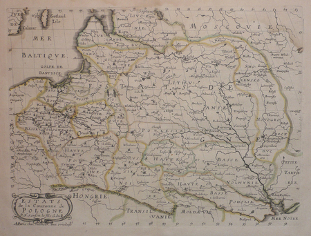
SANSON d'ABBEVILLE (Nicolas);
Estats de la couronne de Pologne.
Paris chez l'autheur 1657 191 x 253 mm.
Référence libraire : LBW0418d
|
|
|
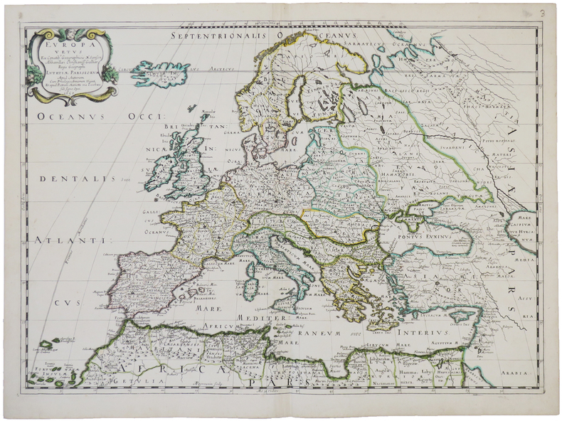
SANSON d'ABBEVILLE (Nicolas).
Europa vetus.
Paris, chez l'auteur et chez Pierre Mariette, 1650. 393 x 553 mm.
Référence libraire : LBW-4944
|
|
|
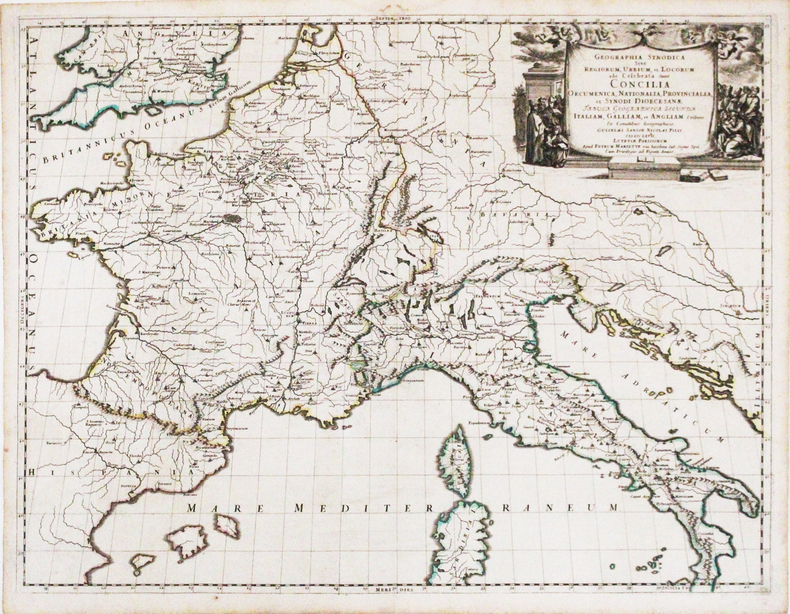
SANSON d'ABBEVILLE (Nicolas).
Geographia synodica sive regionum, urbium, et locorum, ubi celebrata sunt Concilia œcumenica, nationalia, provincialia, et synodi diœcesanæ tabula geographica secunda Italiam, Galliam, et Angliam.
Paris, Pierre Mariette, 1667. 422 x 554 mm.
Référence libraire : LBW-3266
|
|
|
SANDS M. Et Mme H. et BOLAND Henri
Guides-Joanne : Angleterre , Écosse , Irlande . Complet De Sa Carte Indépendante En Fin D'ouvrage
Paris - Londres - New York Hachette & Cie 1908 In 16 Collection " Des Guides-Joanne " avec 7 plans et 10 cartes en couleurs dont certaines dépliantes . Nombreuses publicités , notamment d'hôtels mais aussi de Michelin , de chocolat Menier etc . Illustré de photographies en noir et blanc .- 190 p. + 152 p. , 450 gr.
Référence libraire : 015241

|
|
|
 Recevoir par e-mail
 Télécharger en PDF
 Flux RSS


