|
Scott, Cameron: Editor
Nanaimo Magazine, June 1993 - Gabriola Island Diving Photo on Cover
46 pages. Features: Nice photo of Harleys in front of the Queen's; Beachcombing - photo-illustrated article by Dave Drexhage; Hiking - photo-illustrated article by Jean Macleod le Cheminant - with maps of local hiking destinations; Sanctuary of the Sea - Gabriola Pass may harbour one of Canada's first Marine Reserves - photo-illustrated article by Iain Cuthbert; Nice photo ad for the ill-fated Pacliacchi's Restaurant in the old downtown firehall features photo outside the restaurant with dozens of supporters; Dozens of ads for local small businesses; and more. Moderate wear. Unmarked. A sound copy. Book

|
|
|
Scott, Munroe; McClure, Robert (Signed)
McClure : The China Years of Dr. Bob McClure *SIGNED BY SUBJECT*
409 pages. Dr. McClure's attractive signature upon half-title page. "This book started out to be a full biography of Dr. Bob McClure from his birth in 1900 up to the present time. It gradually transformed itself into something that may seem to fall halfway between an adventure story and a history of China through the first half of the twentieth century." - from Foreward. Prior owner's neatly written gift greetings upon half-title page which has a small piece cleanly clipped from top corner. Maps printed upon endpapers. Contents clean and unmarked. Light wear. Excellent copy. Book
|
|
|
Scott, Schomberg
Culzean : a History and Guidebook
No marks or inscriptions to contents. No creasing to covers. A very clean very tight copy with bright unmarked silightly rubbed boards, staples not rusted and no bumping to corners. 68pp. Culzean in the province of Carrick in South Ayrshire became the stronghold of the Kennedy clan whose roots go back to the 12th century. First edition, second printing. We do not use stock photos, the picture displayed is of the actual book for sale. Every one of our books is in stock in the UK ready for immediate delivery.

|
|
|
Scott-Elliot, W.
THE STORY OF ATLANTIS. A Geographical, Historical, and Ethnological Sketch. With a Preface by A. P. Sinnett.
pp. xiii, 87. Four colored folding maps of the World's Configuration. 8vo. Original full cloth binding. Joints detached. Old water spotting not affecting text. This edition was first issued in 1909. Scarce. **PRICE JUST REDUCED! OCC 6
|
|
|
SCULPTURE MONDIALE par André MALRAUX.
Le musée imaginaire de la sculpture mondiale volume 2 : des bas-reliefs aux grottes sacrées. Richement documenté (planches en couleurs, héliogravures, cartes).
Ed. Gallimard 1954 (coll. la Galerie de la Pléiade). Bel exemplaire relié, reliure pleine toile ornée et jaquette d'éd., gd et fort in-8, 512 pages + planches.
書籍販売業者の参照番号
: AUB-6203
|
|
|
SEACHART SCOTLAND - JOHN MARR, JOHN THORNTON.
A New Description of the East Coast of Scotland from Berwick to Bokannais: Wherein is fully shewed the Chief Forelands, Bays, Roads, Rivers, Havens, Creeks, Sands, Shoals, Depths of Water and Anchoridg, with the Course of the Tides, and what Moon make...
(London, ca. 1810). Folio. (45 x 28 cm.). Later hcloth. Gilt lettering on upper cover. 4 pp. in folio. + engraved map (44 x 52 cm.) Chart of the East Coast of Scotland Bu John Thornton. Left and right margins shaved (no loss of image). Light browning and a few brownspots.
書籍販売業者の参照番号
: 55309
|
|
|
SEACHART SCOTLAND - JOHN MARR, JOHN THORNTON.
A New Description of the East Coast of Scotland from Berwick to Bokannais: Wherein is fully shewed the Chief Forelands, Bays, Roads, Rivers, Havens, Creeks, Sands, Shoals, Depths of Water and Anchoridg, with the Course of the Tides, and what Moon make...
(London, ca. 1810). Folio. (45 x 28 cm.). Later hcloth. Gilt lettering on upper cover. 4 pp. in folio. + engraved map (44 x 52 cm.) Chart of the East Coast of Scotland Bu John Thornton. Left and right margins shaved (no loss of image). Light browning and a few brownspots.
|
|
|
SEBASTIAN MÜNSTER, (Map-maker), (1488-1552).
[HAND-COLOURED MAP of ASIA MINOR by MÜNSTER] Von den Landern Asie.
Very Good German Original hand-colored map. 4to. 27x19 cm, with cartoon frame: 40x30 cm. A decorative small map of Asia Minor, from east to the Euphrates, South to the Mediterranean, North to the Black Sea and including Thracia (Thrace). It shows Thracia, Bithynia, Pontus, Paphlagonia, Galatia, Phrygia Minor, Mysia, Phrygia Maior, Lydia, Ionia, Ephesos, Meandros, Lycus [Valley], Caria, Lycia, Pamphylia, Cilicia, Lycaoni, Pisidia, Argos Mt., Taurus Mt., Sebastia, Cappadocia, Armenia, Syria, Nicopolis. Seas decorated with sea monsters. The land filled with mountains. "Münster's Cosmography was one of the most influential geographical works of the 16th Century. It was published in a number of editions over a half century and was continuously revised and updated to include new illustrations and updated information. Sebastian Münster (1488-1552) was a cosmographer and professor of Hebrew who taught at Tübingen, Heidelberg, and Basel. He settled in the latter in 1529 and died there, of plague, in 1552. As a young man, Münster joined the Franciscan order and studied philosophy in Heidelberg. He also studied geography and mathematics in Loewen, as well as Hebrew at Freiburg. In 1512, he was ordained as a priest and taught philosophy and theology at Tübingen from 1514 to 1518. While in Tübingen, he also conducted further studies in geography. He moved to Basel in 1518 and published a Hebrew grammar, one of the first books in Hebrew published in Germany. In 1521 Münster moved again, back to Heidelberg, where he continued to publish Hebrew texts and the first German-produced books in Aramaic. After converting to Protestantism in 1529, he took over the chair of Hebrew at Basel, where he published his main Hebrew work, a two-volume Old Testament with a Latin translation. Münster made himself the center of a large network of scholars from whom he obtained geographic descriptions, maps, and directions. He published his first known map, a map of Germany, in 1525. Three years later, he released a treatise on sundials. In 1540, he published Geographia universalis vetus et nova, an updated edition of Ptolemy's Geographia. In addition to the Ptolemaic maps, Münster added 21 modern maps. One of Münster's innovations was to include one map for each continent, a concept that would influence Ortelius and other early atlas makers. The Geographia was reprinted in 1542, 1545, and 1552. Münster is best known today for his Cosmographia universalis, the first German-language description of the world. It was first published in 1554 and contained 471 woodcuts and 26 maps over 6 volumes. Many of the maps were taken from the Geographia and modified over time. It was released in at least 46 editions in 6 languages by 1650, with 21 German editions alone. The Cosmographia was widely used in the sixteenth and seventeenth centuries and the text, woodcuts, and maps all influenced geographical thought for generations.".
|
|
|
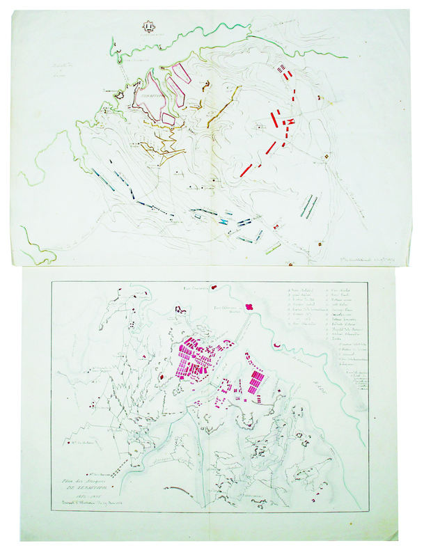
SEBASTOPOL. MANUSCRIT.
[Plan du siège de Sébastopol] [et] Plan des attaques de Sébastopol.
1854-1855. 272 x 422 mm et 288 x 386 mm, sur papier fin.
書籍販売業者の参照番号
: LBW-4226
|
|
|
SEBE Alain
ALGER : CARTES POSTALES ANCIENNES.
L'Harmattan, 1994. In-8 broché, 111 pages, album illustré de reproductions de cartes postales anciennes. Bel exemplaire, état neuf.
書籍販売業者の参照番号
: 5532
|
|
|
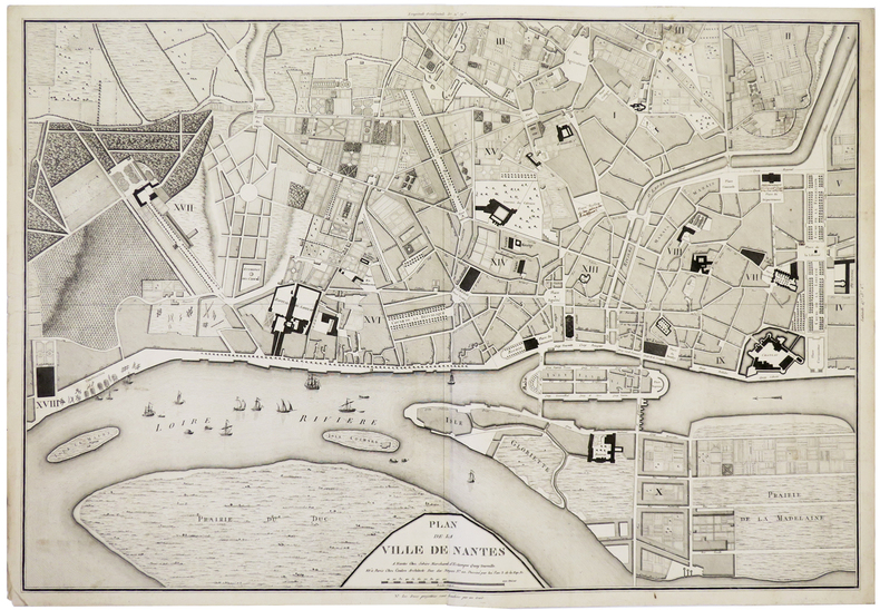
SEBIRE (J.) & COULON.
[NANTES] Plan de la ville de Nantes.
Nantes, Sebire, et Paris, Coulon, An 3. de la Rép. Fr. [1795]. 490 x 707 mm.
書籍販売業者の参照番号
: LBW-5910
|
|
|
SEDAN
Carte au 1/200 000e. Sans date.
Une feuille 32x50 cm.
|
|
|
Seeger Maps
Ozaukee Co. WI
Seeger Maps. Used - Good. Shows some signs of wear and may have some markings on the inside. Seeger Maps unknown
書籍販売業者の参照番号
: GRP68037819 ISBN : 1890552895 9781890552893
|
|
|
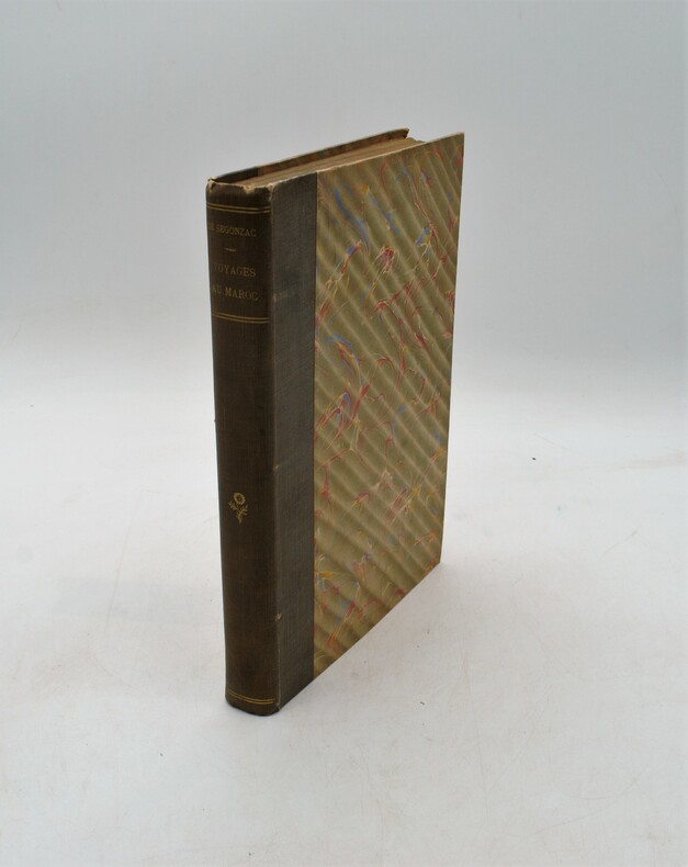
SEGONZAC (René Marquis de).
Voyages au Maroc (1899-1901). Avec 178 photographies Dont 20 grandes planches hors texte. Une carte en couleurs hors texte Et des Annexes politique, astronomique, météorologique, botanique, entomologique, numismatique, géographique Par MM. DE VANSSAY, HASSE et DE VILLEDEUIL, MM. LE BONNET et BEDEL, E. FICHEUR, R. DE FLOTTE ROQUEVAIRE.
Paris, Librairie Armand Colin, 1903. grand in-8 ( 280x195mm), demi toile époque , dos lisse avec auteur et titre , xi-408pp-1ff , illustré de 20 planches hors texte dépliantes (panorama) et de nombreuses photos , un graphique et une carte in fine.
書籍販売業者の参照番号
: PHO-1142
|
|
|
SEGUIN Jean-Pierre
Le jeu de carte.
Paris: Hermann, 1968 pet. in-4, 346 pages, riche illustration, bibliographie. Reliure toile, jaquette avec pet. marques.
書籍販売業者の参照番号
: 1105424
|
|
|
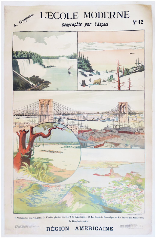
SEIGNETTE (Adrien) & LUNOIS (Alexandre).
L'École moderne. Géographie par l'aspect. N°12. Région américaine.
Paris, Paul Dupont, [1900]. 1,22 x 0,85 m ; montée sur toile.
書籍販売業者の参照番号
: LBW-7872
|
|
|
SELF INSTRUCTOR.
The Self Instructor, or, Young Man's Best Companion; being an Introduction to all the various branches of useful Learning and Knowledge. Containing Writing, Grammar, Arithmetic, Astronomy, Geography, Chronology, and Miscellaneous Articles. To which is added, The Artist's Assistant; comprising the Arts of Drawing, Perspective, Etching, Engraving, Mezzotinto, Scraping, Painting, Drying, Colouring of Maps, etc. A brief account of Naval and Military Affairs. Also, various useful Medicinal Receipts.
8vo (218 x 135 mm), [4], 593, [3] pp., 3pp. of contents at end, folding engraved map of the world before the engraved and printed titles, 7 engraved plates, contemporary tree calf, spine gilt, morocco label, a nice copy. The map and the engraved frontispiece are "Published by Nuttall, Fisher, & Co., Liverpool, Sept. 1814, and Aug. 1815", respectively.
|
|
|
Seltzer Leon
THE COLUMBIA LIPPINCOTT GAZETTEER OF THE WORLD with 1961 Supplement
New York: Columbia University Press 1962. pp. x 2148 22. thumb indexed. Original brown cloth binding very good with slight wear only. Contents clean and tight no inscriptions. a very good clean tight copy. Please note: This is a substantial volume and a small shipping surcharge is likely. Second Printing. Hard Cover. Very Good. 4to. Columbia University Press Hardcover
書籍販売業者の参照番号
: 008077
|
|
|
Selwyn, Victor
Plan Your Route: The New Approach to Map Reading
Good+ Hardback with good+ dust jacket. Including the electronic technology and satellite navigation. Minor shelf wear. Corners of boards have been knocked very slightly. Clean text. Black & white/colour illustrations. 196p.
|
|
|
SELZ
Carte allemande au 1/80 000?. Fin XIXe.
1 feuille repli?e. 31,5x45 cm.
|
|
|
SEMIR, Ramon de
MAPA DE VALL FERRERA - 1951
Edit. Con. Sup. Geográfico, 1951. Mapa topográfico excursionista. 1:37.500. Mapa entelado y plegado. Firma antiguo proopietario. Muy buen ejemplar.
|
|
|
SEMIR, Ramon de
RIBAGORÇA. Llauset. Mulleres. Beciberri. Fenarroi - Granollers 1961 - Mapa
Granollers, Editorial Alpina, 1961. Mapa topográfico excursionista. Escala 1:25.000. Mapa entelado y plegado. Muy buen ejemplar.
|
|
|
SEMPÉ
Sempe : A question of balance
2006, Phaidon Press, coffret cartonné toilé contenant 23 cartes postales sur le thème du vélo (dessins et aquarelles) - manque 1 carte postale | Etat : bon, coffret défraîchi, cartes postales en très bon état, manque 1 carte postale (Ref.: ref98251)
書籍販売業者の参照番号
: 9782845233112
|
|
|
SEMUR
Carte routi?re de l'arrondissement de Semur (C?te d'Or) au 1/50 000e. Sans date.
Une feuille 64x49 cm. Plis r?par?s.
|
|
|
Senecal, C.O.; Yorston, R.B.; Faribault, E.R.
Province of Nova Scotia, Halifax County (City of Halifax Sheet, No. 68)
Approx. 27" x 19". Library markings. Faint discolouration to upper right corner. Map

|
|
|
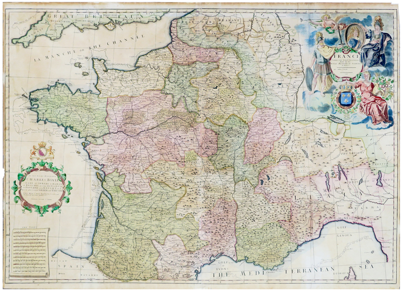
SENEX (John).
France corrected from ye observations made by the Royal Academy of Sciences at Paris.
1708. 635 x 918 mm.
書籍販売業者の参照番号
: LBW-5811
|
|
|
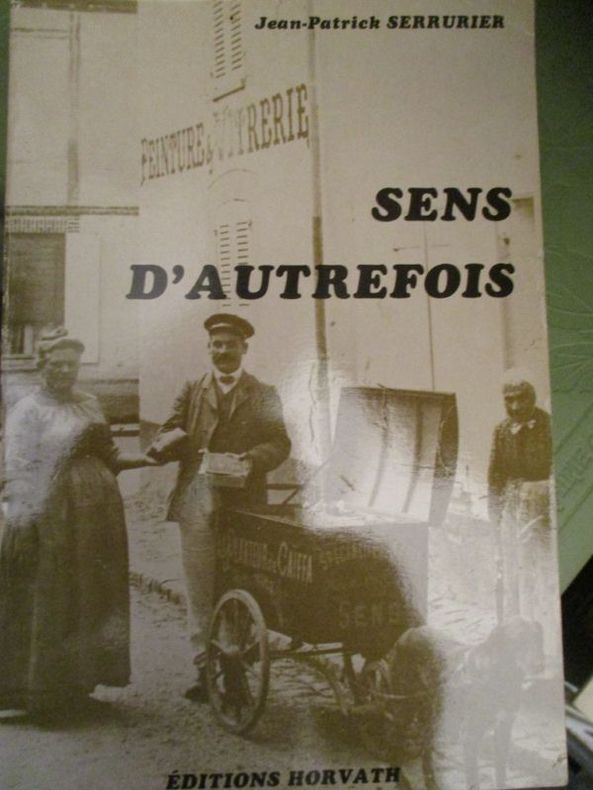
serrurier (jean patrick)
sens d'autrefois
édition horvath 1982 In8 broché 193 pages
書籍販売業者の参照番号
: 4730
|
|
|
Service de Tourisme Michelin
CARTE MICHELIN n° 90 "CORSE" Edition 1961
Une carte Michelin au 200 000éme, bon état
書籍販売業者の参照番号
: LFA0024c
|
|
|
SERVICE GEOGRAPHIQUE DE L'ARMEE.
Matériaux d'étude topologique pour l'Algérie et la Tunisie. 1, 3, 4, 5, 6emes séries.
1900 in-8, br. L'ensemble, sans la 2eme série: Paris Impr. du Service géographique de l'armée 1900-1906,
書籍販売業者の参照番号
: 3327
|
|
|
Service Géographique de l'Armée
CARTE n° 178 "GRENOBLE S.E."
Type 1889, révisée en 1897, état moyen
書籍販売業者の参照番号
: LFA00252
|
|
|
Service Géographique de l'Armée
CARTE n° 178 "GRENOBLE"
Type 1889, révisée en 1897, format 53 x 75 cm, assez bon état
書籍販売業者の参照番号
: LFA00254
|
|
|
Service géographique de l'armée
Les Ecritures sur les cartes topographiques
Paris : Service géographique de l'armée, 1934 In-8, 27 (17) p., fig. [92]Note(s) : La préface indique comme auteur M. Zabern, chef dessinateur
書籍販売業者の参照番号
: 12493
|
|
|
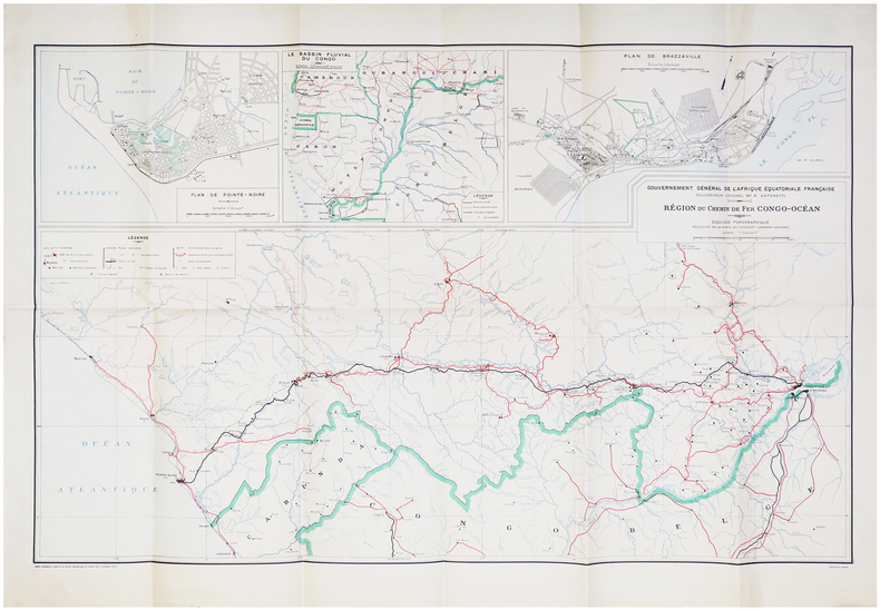
SERVICE GÉOGRAPHIQUE de l'ARMÉE.
[RÉPUBLIQUE du CONGO] Gouvernement général de l'Afrique Équatoriale Française. Gouverneur général M.r R. Antonetti. Région du chemin de fer Congo-Océan.
Paris, Service Géographique de l'Armée, 1934. 638 x 994 mm.
書籍販売業者の参照番号
: LBW-6664
|
|
|
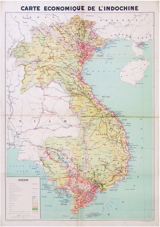
SERVICE GÉOGRAPHIQUE de l'INDOCHINE.
[INDOCHINE] Carte économique de l'Indochine.
Mars 1937. 870 x 604 mm.
書籍販売業者の参照番号
: LBW-6795
|
|
|
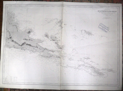
Service hydrographique de la Marine
Oc�an Pacifique. Nouvelle Guin�e : De la Pointe Keppel � la Baie Hercule �les d'Entrecasteaux et archipel de la Louisiade. D'apr�s les cartes les plus r�centes de l'Amiraut� anglaise. carte marine
Service hydrographique de la Marine 1938. Carte. Tr�s bon. Aucune reliure. Service hydrographique de la Marine 1899. Edition n� 2 juin 1938. N� 4977. Format : 106 x 75 cm. Tampon : carte condamn�e dangereuse pour la navigation. Pliure : une centrale petite trace de torsion longitudinale. Etat : petites torsions. Service hydrographique de la Marine unknown
書籍販売業者の参照番号
: 0583

|
|
|
Service hydrographique de la Marine
Océan Pacifique. Nouvelle Guinée : De la Pointe Keppel à la Baie Hercule, Îles d'Entrecasteaux et archipel de la Louisiade. D'après les cartes les plus récentes de l'Amirauté anglaise. [carte marine]
1938 Service hydrographique de la Marine, 1899. Edition n° 2, juin 1938. N° 4977. Format : 106 x 75 cm.
書籍販売業者の参照番号
: 583
|
|
|
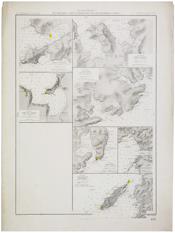
SERVICE HYDROGRAPHIQUE DE LA MARINE.
[BALÉARES] Îles Baléares. Ports et mouillages des îles Majorque et Ivice.
1892-1911. 647 x 434 mm.
書籍販売業者の参照番号
: LBW-5435
|
|
|
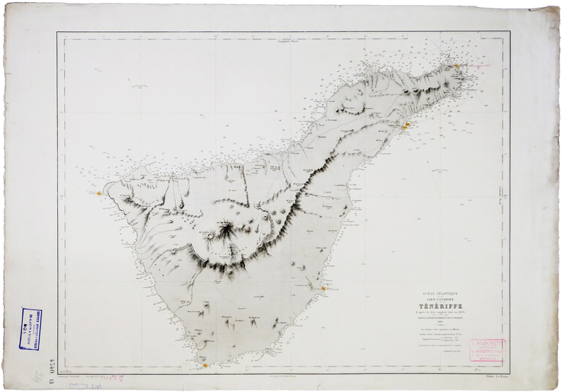
SERVICE HYDROGRAPHIQUE DE LA MARINE.
[CANARIES] Ténériffe.
1888. 465 x 617 mm.
書籍販売業者の参照番号
: LBW-5486
|
|
|
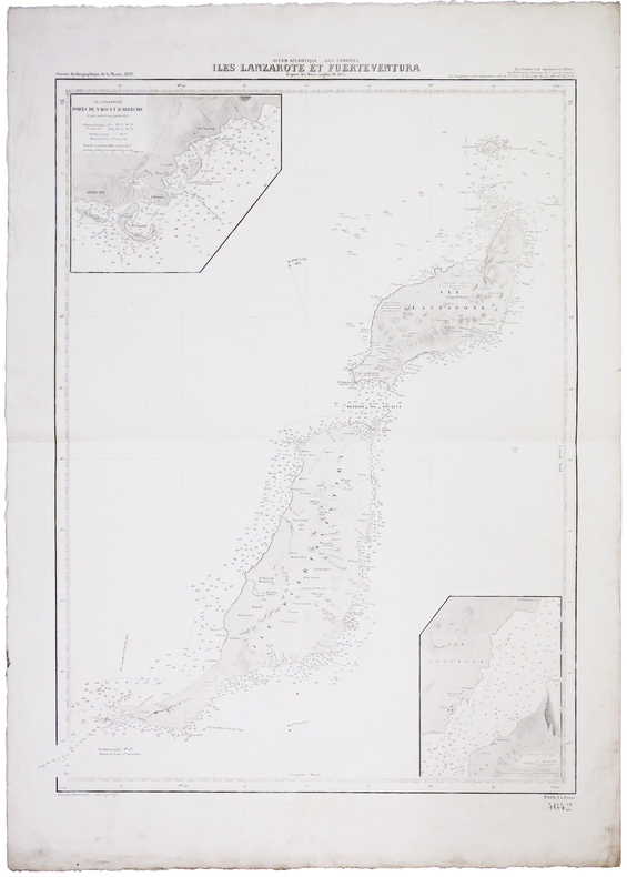
SERVICE HYDROGRAPHIQUE DE LA MARINE.
[CANARIES] Îles Lanzarote et Furteventura.
1892. 638 x 471 mm.
書籍販売業者の参照番号
: LBW-5450
|
|
|
SERVICE HYDROGRAPHIQUE DE LA MARINE.
[CEYLAN/SRI LANKA] Ile de Ceylan. Port de Colombo et ses approches.
Paris, 1888. 615 x 441 mm.
書籍販売業者の参照番号
: LBW-2417

|
|
|
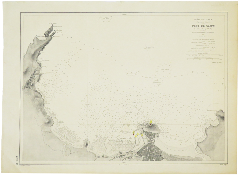
SERVICE HYDROGRAPHIQUE DE LA MARINE.
[GIJÓN] Port de Gijón.
Service Hydrographique de la Marine, 1887. 319 x 432 mm.
書籍販売業者の参照番号
: LBW-5712
|
|
|
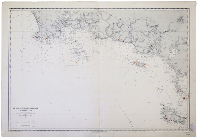
SERVICE HYDROGRAPHIQUE DE LA MARINE.
[MORBIHAN/QUIBERON/BELLE-ÎLE-en-MER/GROIX/GLÉNAN] Côte ouest de France. De la Pointe de Penmarch à Belle-Île. Abords de Lorient.
Service Hydrographique de la Marine, 1912-1931. 697 x 984 mm.
書籍販売業者の参照番号
: LBW-5229
|
|
|
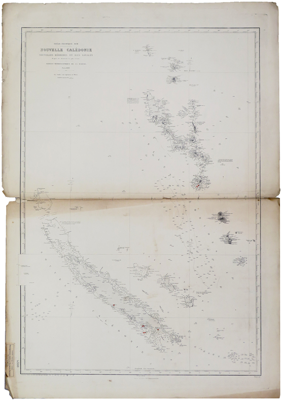
SERVICE HYDROGRAPHIQUE DE LA MARINE.
[NOUVELLE-CALÉDONIE] Océan Pacifique Sud. Nouvelle Calédonie, Nouvelles Hébrides et îles Loyalty.
Paris, Service Hydrographique de la Marine, 1888-1909. 943 x 654 mm.
書籍販売業者の参照番号
: LBW-6011
|
|
|
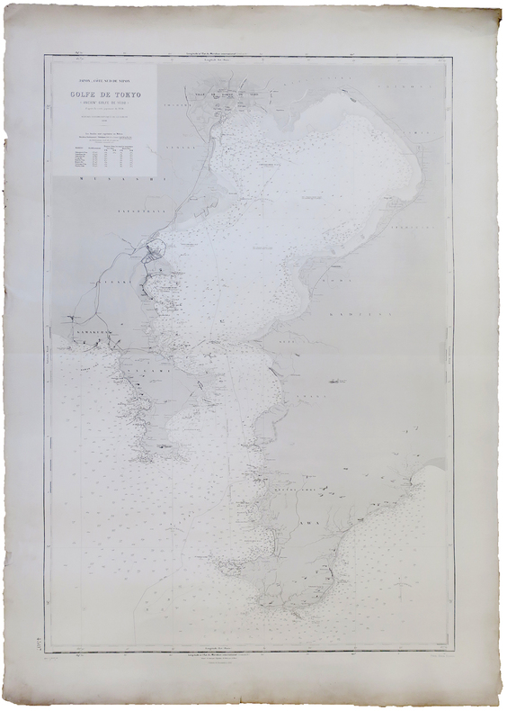
SERVICE HYDROGRAPHIQUE DE LA MARINE.
[TOKYO] Japon - Côte sud de Nipon. Golfe de Tokyo (ancien.t de Yédo).
Service Hydrographique de la Marine, 1891-1914. 940 x 629 mm.
書籍販売業者の参照番号
: LBW-5908
|
|
|
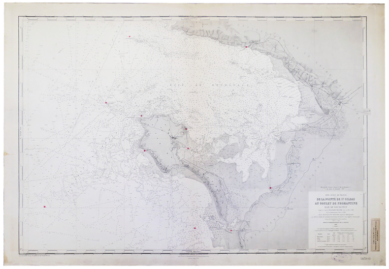
SERVICE HYDROGRAPHIQUE DE LA MARINE.
[VENDÉE/ÎLE de NOIRMOUTIER] Côte ouest de France. De la Pointe de St. Gildas au Goulet de Fromantine. Baie de Bourgneuf.
Service Hydrographique de la Marine, 1900-1922. 690 x 977 mm.
書籍販売業者の参照番号
: LBW-5214
|
|
|
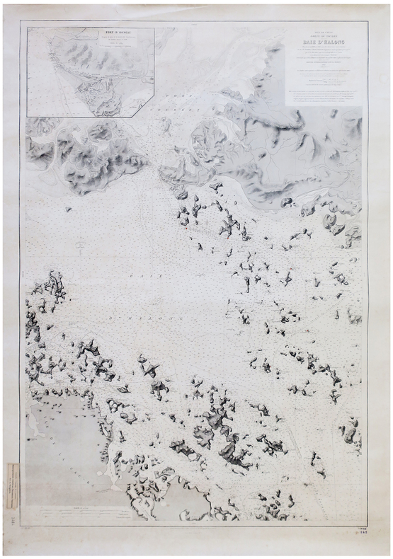
SERVICE HYDROGRAPHIQUE DE LA MARINE.
[VIETNAM/BAIE d'HALONG] Mer de Chine. Golfe du Tonkin. Baie d'Halong.
Service Hydrographique de la Marine, 1912-1936. 669 x 980 mm.
書籍販売業者の参照番号
: LBW-5773
|
|
|
SERVICE HYDROGRAPHIQUE.
Catalogue des cartes, plans et ouvrages qui composent l'hydrographie française au Ier Janvier 1935.
1935 in-8, XVI, 326pp., br. Paris Imprimerie nationale 1935,
書籍販売業者の参照番号
: 3303
|
|
|
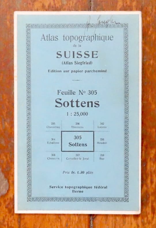
Service topographique fédéral:
Atlas topographique de la Suisse (Atlas Siegfried) - Feuille n° 305, Sottens.
Berne, Service topographique fédéral, 1882. Carte au 1 : 25,000, au format de 44 x 35 cm., sur papier parcheminé. Nom de possesseur au titre, pour le reste en très belle condition.
書籍販売業者の参照番号
: 16904
|
|
|
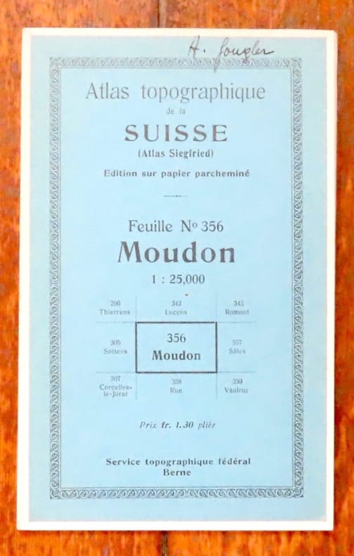
Service topographique fédéral:
Atlas topographique de la Suisse (Atlas Siegfried) - Feuille n° 356, Moudon.
Berne, Service topographique fédéral, 1880. Carte au 1 : 25,000, au format de 43 x 35 cm., sur papier parcheminé. Nom de possesseur au titre, pour le reste en très belle condition.
書籍販売業者の参照番号
: 16905
|
|
|
Service topographique fédéral:
Atlas topographique de la Suisse (Atlas Siegfried) - Feuille n° 342, Lucens.
Berne, Service topographique fédéral, 1931. Carte au 1 : 25,000, au format de 43 x 35 cm., sur papier parcheminé. Nom de possesseur au titre, pour le reste en très belle condition.
書籍販売業者の参照番号
: 16908

|
|
 検索結果のメールを受信する
 PDFファイルの検索結果をダウンロード
 RSSフィード


