|
Waldburger, A
Ragaz und Umgebung. Ragaz
Ragaz 1910. Karte mit vollst. Wegmarkierung. 1:25 000. Landkarte 55x59 cm, Faltmaß 19x12 cm. [2 Warenabbildungen]
書籍販売業者の参照番号
: 6414

|
|
|
Waley Arthur; maps Endpaper
THE LIFE AND TIMES OF PO CHU-I 772-846 A.D.
George Allen & Unwin. Very Good. 1949. First Edition. Hardcover. 8vo 8" - 9" tall . George Allen & Unwin hardcover
書籍販売業者の参照番号
: 158170
|
|
|
Walk Maps By Tim Locke.
10 Good Walks. GUIDE.
London UK.: Consumers' Association 1992. This is the first edition of this edition. This booklet contains material first published in 1990 in Holiday Which Town and Country Walks Guide. Natural brown stained staple marks. This book will be POSTED AT OUR STANDARD RATES FULLY INSURED UK ONLY . Please email for further details. OFFERED FOR SALE BY A FULL-TIME STOCKHOLDING CAREER BOOKSELLER WHO TELLS YOU WHO THEY ARE AND WHAT THEIR TELEPHONE AND ADDRESS CONTACT DETAILS ARE! POSTED AT OUR STANDARD RATES FULLY INSURED! UK ONLY. FEEL FREE TO E-MAIL FOR PHOTOGRAPHS AND FURTHER DETAILS. Not Signed or Inscribed. Pictorial Card. Very Good AVERAGE/No Jacket. Illus. by Map Illustrations Throughout. 12mo - over 6�" - 7�". Guide. Consumers' Association Hardcover
書籍販売業者の参照番号
: 573493
|
|
|
WALKER'S County Maps.
Walker's Monmouthshire.
Longman Rees and Co. 1839. Early Edition. Hardback. No DW. Brown textured cloth. 9cm x 12.5cm. Linen-backed fold-out map in colour 35cm x 42cm . Ownership signature to inside cover. A lovely copy. 1839 hardcover
書籍販売業者の参照番号
: 78212
|
|
|
Walker, J und C.:
Dorsetshire. (County map).
Engraved map, hand-coloured in outline, dissected into 15 sheets. Mounted on linen, folding into blue cloth covers, original printed label. Dimensions: 340 x 410 mm. (13 x 16 inches). Landkarten de
|
|
|
Wallace E. Caldwell; Editor Edward H. Merrill;editors Illustrator and maps by Erwin Raisz; maps byIntroduction Lowell Thomas
The New Popular History of the World: The Story of Mankind From Earliest Times to the Present Day 2 VOLUMES SET
Greystone 1964. Hardcover. Very Good. Very good 2 VOLUME SET of hardcovers. No DJs. Ex-Library with usual markings. Text is clean and unmarked. Covers show very minor shelf wear. Bindings tight hinges strong.; 100% Satisfaction Guaranteed! Ships same or next business day! Greystone hardcover
書籍販売業者の参照番号
: 1203130122
|
|
|
Wallis Helen Keeper of Maps British Library
The Voyage of Sir Francis Drake Mapped in Silver and Gold
Friends of Bancroft Library 1979. Very Good. Wallis Helen Keeper of Maps British Library. The Voyage of Sir Francis Drake Mapped in Silver and Gold. Berkeley: Friends of Bancroft Library 1979. 26pp. 8vo. Blue wraps. Book condition: Very good. Friends of Bancroft Keepsake #27. Friends of Bancroft Library paperback books
書籍販売業者の参照番号
: UWALVOY00LNW
|
|
|
WALLIS James. REID W. HAND COLOURED MAPS
The Panorama: Or Traveller's Instructive Guide; Through England And Wales Exhibiting All The Direct And Principal Cross Roads Cities Towns Villages Parks Canals &C. Accompanied By A Description Of Each County With The Cities And Principal Towns: Likewise a List of Fairs London and County Bankers Members of Parliament The Route of the Mail Coaches and The Postage of Letters. With a Variety of other useful information.
Printed by J. Wallis and Published by W. H. Reid. Pocket edition. 1824. 12.75 x 7.5cm. Bound in early 19th century full speckled calf gilt with gilt decorations to spine and decorative gilt borders to boards slightly worn to extremities. Extra engraved vignette title with an illustration of a coach and horses with engraved contents page opposite. All maps present. Hand-coloured map of England and Wales plus 52 hand-coloured maps of England 40 and Wales 12 163 pages of text. Marbled endpapers. Early ownership signature of Wm. Davies to top of title page and reverse of front free endpaper. Slight offsetting from maps to opposite page otherwise a remarkably clean and sound copy of a very scarce item. James Wallis engraver and publisher at '77 Berwick Street Soho' London from 1812. It is known that he went bankrupt twice in 1801 and 1805. Rights to Wallis's maps later went to Patrick Martin then to Simpkin and Marshall then to the master printer William Lewis. He worked on S. A. Oddy's New General Atlas of the World 1811 Wallis's New Pocket Edition of the English Counties or Travellers Companion. 1812 re-published by P. Martin 1816 maps included in Martin's Sportsman's Almanack 1818 and 1819 and Lewis's New Travellers Guide 1819 and later Wallis's New British Atlas Containing a Complete Set of County Maps S. A. Oddy 1812 re-issued as A New and Improved British Atlas 1813 Wallis's Second and Superior British Atlas; containing a complete set of county maps. 1814 and 1816 Ellis's New and Correct Atlas of England and Wales. 1819; and The Panorama or Traveller's Instructive Guide through England and Wales 1820. [1824] hardcover
書籍販売業者の参照番号
: 73650
|
|
|
Wallis, Geoff & West, Ben
The Rough Guide to Family Fun in Ireland
No marks or inscriptions. No creasing to covers or to spine. A very clean very tight copy with bright unmarked boards and no bumping to corners. 172pp.

|
|
|
Wally Koval
ACCIDENTALLY WES ANDERSON : POSTCARDS
Card Book, ENG, 26 postcards in colour, 160 x 115 mm, NEW, from different places in the world,. ISBN 9781399608725. 26-POSTCARD SET featuring 26 full-colour photographs from the bestselling Accidentally Wes Anderson book, based on the Instagram phenomenon. FOR FANS OF WES ANDERSON and Wally Koval alike, these postcards pay homage to the director's unique style with photographs from the most interesting locations spotted all around the world. STURDY PAD-BOUND BOOK allows for easy browsing and detachment of each postcard individually. Accidentally Wes Anderson: The Book invited us to journey to more than 200 real-life "Andersonian" locations around the world. From the tasteful technicolour of the Venetian Lagoon to Hong Kong's Choi Hung Estate (aptly named after the word for "rainbow" in Cantonese), the collection is an irreverent reverie for the armchair traveller, drenched in nostalgia, whimsy and charm. Now wherever you are in the world - home or away - with this beautiful postcard set you can send a little piece of Wes Anderson's unique aesthetic to your loved ones, complete with your own 'wish you were here' note.

|
|
|
Walvin, James
The Slave Trade (History Files)
Book is in excellent condition, as new. Binding is solid and square, covers have sharp corners, exterior shows no blemishes, text/interior is clean and free of marking of any kind. 144 pages, heavily illustrated, included unopened pack of "facsmile documents" in back pocket. 145 illustrations, 90 in color, 10 facsimile documents.
|
|
|
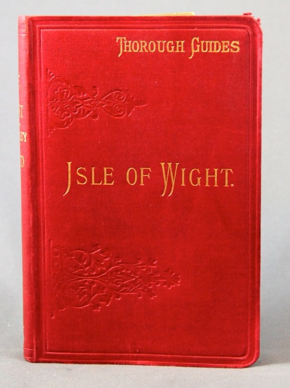
WARD C.S:
The Isle of Wight. With notes for geologists & cyclists.
London, Dulau & Co, 1895. In-8 de X-[4]-96 pages, pleine percaline rouge d'éditeur ornée à froid, dos lisse. Coins supérieur du second plat frotté.
書籍販売業者の参照番号
: 2308
|
|
|
Ward Bob; Photographs & Maps Illustrator
Mountain Biking in the Northern Sierra Volume Two: Grouse Ridge and the Excelsior District
Bobo Productions 1990-01-01. Paperback. Very Good. Very Good Condition. Crisp pages. Tight binding. Great reading copy. Some wavy Pages. Shelf wear on cover. - All products inspected inside and out and shipped by USPS with a tracking number! I highly suggest that you choose expedited shipping. For a small fee you get priority shipping insurance and a padded envelope for the best protection. Bobo Productions paperback
書籍販売業者の参照番号
: 45x00K042B22

|
|
|
Ward, Greg
The Rough Guide to Brittany & Normandy
No marks or inscriptions. No creasing to covers or to spine. A very clean very tight copy with bright unmarked boards, very slight rub to front and no bumping to corners. 462pp. Travel guide to Northern France.

|
|
|
Warner George F.
Diving and Marine Biology : The Ecology of the Sublittoral
Cambridge: Cambridge University Press 1984. 210 pages; numerous b/w illustrations. Original dust jacket near fine minimal fading to spine not price clipped. Hard back binding fine. Contents clean and tight unmarked no inscriptions. A fine copy in a near fine jacket. Signed by Author. First Edition. Hardback. Fine/Near Fine. 8vo. Cambridge University Press Hardcover
書籍販売業者の参照番号
: 022855 ISBN : 0521257514 9780521257510

|
|
|
Warner, Judith and Simon
The South Pennines and the Bronte Country
Book in virtually mint condition. Dust jacket not price clipped or marked or torn with slight creasing to upper edge. 64pp. Ten pages of introduction followed by beautiful photographs of the West Yorkshire area on quality art/photographic paper and accompanied extensive captions..

|
|
|
Warren Maps
Western United States Regional Map
2014-02-09. Good. Ships with Tracking Number! INTERNATIONAL WORLDWIDE Shipping available. May not contain Access Codes or Supplements. May be re-issue. May be ex-library. Shipping & Handling by region. Buy with confidence excellent customer service! unknown
書籍販売業者の参照番号
: 1598623931 ISBN : 1598623931 9781598623932

|
|
|
Warren Maps
Western United States Regional Map
2009-01-01. New. Ships with Tracking Number! INTERNATIONAL WORLDWIDE Shipping available. May be re-issue. Buy with confidence excellent customer service! unknown
書籍販売業者の参照番号
: XH02VBTI0En ISBN : 1890552534 9781890552534

|
|
|
Warren Maps
Western United States Regional Map
2009-01-01. Good. Ships with Tracking Number! INTERNATIONAL WORLDWIDE Shipping available. May not contain Access Codes or Supplements. May be re-issue. May be ex-library. Shipping & Handling by region. Buy with confidence excellent customer service! unknown
書籍販売業者の参照番号
: XH02VBTI0E ISBN : 1890552534 9781890552534

|
|
|
WASHBURN, Wilcomb E. (1915-1997).
Representation of unknown lands in the XIV, XV and XVI Century Cartography.
Coimbra, 1969 [Separata da "Revista da Universidade"]. Folio; 20 pp. Cubiertas originales.

|
|
|
WASHINGTON STATE MAPS O'KEANE James J. Surveyor & Real Estate Agent.
Collection of seven original cyanotype blueprint plat maps of lands available for sale above the Columbia River between Goldendale & Bickleton Washington showing those reserved for the Northern Pacific Railway Co. as well as School Lands and the Yakima Indian Reservation lands. Township No. 4 North Range Nos. 18-19; Township No. 5 North Range Nos. 14 18-19; Township No. 6 North Range Nos. 18-19 East Willamette Meridian.
Vancouver WA: Jas James J. O’Keane Land Office Christ Block 1910-1911. Seven cyanotype blueprint maps sized 14 x 14 in. all w/ fold creases original manuscript annotations w/in the image red annotated checkmarks added afterwards to blank lands as noted by O’Keane in margins minor edgewear rubbing some closed tears to fold creases old tape repairs to versos still a VG- set of maps. First editions of these scarce land plat maps for Klickitat County Washington at the beginning of the 20th Century executed during the land rush spawned by the development of the Northern Pacific Railway Co.’s North Bank Road Spokane Portland & Seattle Railway. These plat maps show the odd sections alongside the rights of way for the Northern Pacific Railway Co. & Great Northern the required sections for “School†lands as well as carefully noting all of the landowners at the time. In addition the boundaries on the Township maps also indicate the limits of the Yakima Indian Reservation at the time as well as Rock Creek in Klickitat County it’s tributaries and the Columbia River. For the purpose of those interested in purchasing land for wheat farms or other development purposes O’Keane has carefully indicated all of those lots still vacant or available with red check marks. Wheat farms and other small landholdings at the time were producing agricultural products to be shipped into Goldendale WA and then taken by wagon road to Cliffs WA where the Samuel Hill Syndicate was constructing a cement and stone dam for irrigation and a great deal of infrastructure. Within two years after the drawing of these maps the railroads shifted to Wishram to connect with the Oregon Truck Railway and much of the development simply evaporated. Rock Creek had served for generations as a seasonal Pow Wow site and pathway for Northwest Chinook and Sahaptin Indians to Celilo Falls -- whom were consolidated after 1855 into the Confederated Tribes of the Yakima Nation. O’Keane 1871-1972 was the son of John J. O’Keane first Indian Agent to the Tulalip Indian Reservation and by the 1890s was a draftsman and surveyor with the U.S. Land Office based in Vancouver WA. By 1903 when he marries he was operating as a real estate agent and land developer out of the Christ Block in downtown Vancouver WA and later began working as a timber cruiser for the Dole Lumber Co. and surveyor for the Alaska United Copper Co. No similar copies in Worldcat; See: James O’Keane Papers Davies Family Research Library Oregon Historical Society MSS 1719; Washington State Historical Society Klickitat Heritage Klickitat County Historical Society Vol. 34 2011. Jas [James] J. O’Keane, Land Office, Christ Block, unknown
書籍販売業者の参照番号
: 56777
|
|
|
Waterford Press Corporate Author/ National Geographic Maps Corporate Author
Cape Cod Adventure Set: Map & Naturalist Guide
Waterford Pr 2015. Hardcover. New. paperback/map edition. 14 pages. 9.25x4.50x0.25 inches. Waterford Pr hardcover
書籍販売業者の参照番号
: 2-1583559248 ISBN : 1583559248 9781583559246

|
|
|
Waterford Press Corporate Author/ National Geographic Maps Corporate Author
Denali National Park & Preserve Adventure Set: Map & Naturalist Guide
Waterford Pr 2015. Paperback. New. paperback/map edition. 14 pages. 9.25x4.50x0.25 inches. Waterford Pr paperback
書籍販売業者の参照番号
: __1583559256 ISBN : 1583559256 9781583559253

|
|
|
Waterford Press National Geographic Maps
Glacier/Waterton Lakes National Parks Adventure Set: Travel Map & Wildlife Guide
Waterford Press. New. Special order direct from the distributor Waterford Press unknown
書籍販売業者の参照番号
: ING9781583559277 ISBN : 1583559272 9781583559277

|
|
|
Waterford Press Corporate Author/ National Geographic Maps Corporate Author
Grand Canyon National Park Adventure Set
Waterford Pr 2015. Paperback. New. paperback/map edition. 14 pages. 9.25x4.50x0.25 inches. Waterford Pr paperback
書籍販売業者の参照番号
: 2-1583559108 ISBN : 1583559108 9781583559109

|
|
|
Waterford Press National Geographic Maps
Great Smoky Mountains National Park Adventure Set: Trail Map & Wildlife Guide
Waterford Press. New. Special order direct from the distributor Waterford Press unknown
書籍販売業者の参照番号
: ING9781583559123 ISBN : 1583559124 9781583559123

|
|
|
Waterford Press National Geographic Maps
Hawaiian Islands Adventure Set: Travel Map & Wildlife Guide
Waterford Press. New. Special order direct from the distributor Waterford Press unknown
書籍販売業者の参照番号
: ING9781583559130 ISBN : 1583559132 9781583559130

|
|
|
Waterford Press Compiler/ National Geographic Maps Compiler
Springer & Cohutta Mountains Adventure Set: Map & Naturalist Guide
Waterford Pr 2016. Hardcover. New. paperback/map edition. 14 pages. 9.25x4.25x0.10 inches. Waterford Pr hardcover
書籍販売業者の参照番号
: 2-1583559639 ISBN : 1583559639 9781583559635
|
|
|
Waterford Press Corporate Author/ National Geographic Maps Corporate Author
The Great Canadian Rockies Adventure Set
Waterford Pr 2015. Paperback. New. paperback/map edition. 14 pages. 9.25x4.50x0.25 inches. Waterford Pr paperback
書籍販売業者の参照番号
: 2-158355906X ISBN : 158355906X 9781583559062

|
|
|
Watson Jane Werner Illustrated by Maps By Henri Fluchere
THE INDUS South Asia's Highway of History
Champaign Ill: Garrad 1970 Hard Cover. FINE in a Near Fine Dustjacket. Juvenile nonfiction illustrated with maps and photos. Book is in uread condition. Champaign, Ill: Garrad, 1970 hardcover
書籍販売業者の参照番号
: 00915

|
|
|
Watson, Ken W. (Signed)
The Rideau Route: Exploring the Pre-Canal Waterway
Signed, without inscription, by author upon title page. 146 pages. Bibliography. "Takes the reader on a 1783 canoe trip along the Rideau Route, revealing the landscape as it appeared prior to any European settlement. Transcriptions and maps of Lt. French's 1783 survey, as well as those of Lt. Joshua Jebb in 1816 and Samuel Clowes in 1823-24, are included as first hand accounts of the route. This newly revealed pre-canal engineering achievement will allow readers to better understand and appreciate the enormous engineering achievement of the Rideau Canal. Profusely illustrated with maps and period paintings." - from back cover. Clean and unmarked with light wear. A quality copy. Book

|
|
|
WATTS E. J. M. with illustrations and maps by SOUTER D. H
STORIES FROM AUSTRALIAN HISTORY
William Brooks & Co. Sydney 1928. 224 pp tinted end-papers b&w illustrations pen marks on upper board damp stained else good copy in papered boards with blue cloth spine. . Third edition. William Brooks & Co., Sydney, 1928 hardcover
書籍販売業者の参照番号
: 227456
|
|
|
WATTS E. J. M. with illustrations and maps by SOUTER D. H
STORIES FROM AUSTRALIAN HISTORY
William Brooks & Co. Sydney c. 1910. 224 pp b&w illustrations bookplate on front paste-down stamp on front end-paper end-papers browned losses to paper covering boards else good copy in papered boards. . Second edition. William Brooks & Co., Sydney, c. 1910 hardcover
書籍販売業者の参照番号
: 226350
|
|
|
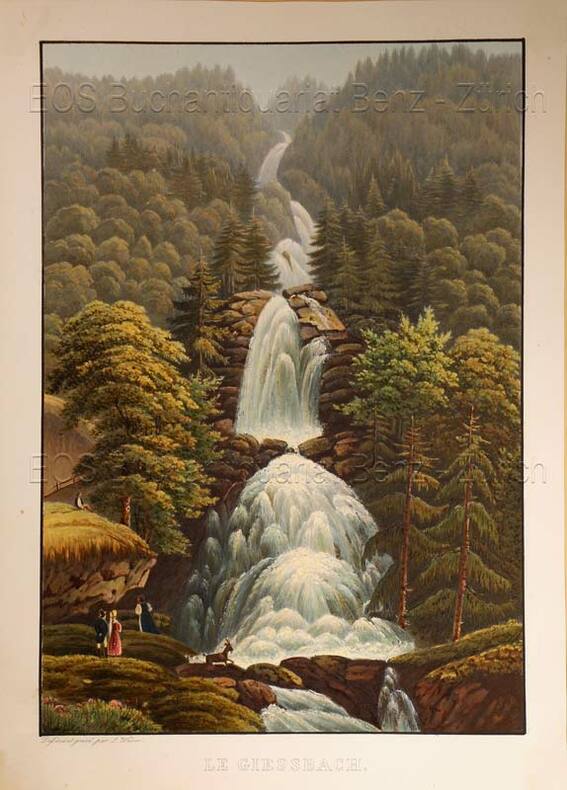
Weber, Lukas (1811-1860):
Le Giessbach.
O.O., um 1935. Altkolorierte Aquatinta von Lukas Weber. Bildgrösse: 24,8 x 17,3 cm. Blattgrösse: 28,3 x 20,2 cm.
書籍販売業者の参照番号
: 619DG
|
|
|
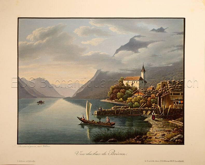
Weber, Lukas (1811-1860):
Vue du lac de Brienz.
Zürich, H. F. Leuthold, um 1840. Altkolorierte Aquatinta von Lukas Weber. Bildgrösse: 13 x 17,3 cm. Blattgrösse: 17,1 x 21,5 cm.
書籍販売業者の参照番号
: 781CG
|
|
|
Weber, Lukas (1811-1860)
Le Giessbach.
O.O., um 1935. Altkolorierte Aquatinta von Lukas Weber. Bildgrösse: 24,8 x 17,3 cm. Blattgrösse: 28,3 x 20,2 cm. + Wichtig: Für unsere Kunden in der EU erfolgt der Versand alle 14 Tage verzollt ab Deutschland / Postbank-Konto in Deutschland vorhanden +, Abb.
書籍販売業者の参照番号
: 619DG

|
|
|
Weber, Lukas (1811-1860)
Vue du lac de Brienz.
Zürich, H. F. Leuthold, um 1840. Altkolorierte Aquatinta von Lukas Weber. Bildgrösse: 13 x 17,3 cm. Blattgrösse: 17,1 x 21,5 cm. + Wichtig: Für unsere Kunden in der EU erfolgt der Versand alle 14 Tage verzollt ab Deutschland / Postbank-Konto in Deutschland vorhanden +, Abb.
書籍販売業者の参照番号
: 781CG

|
|
|
Wedgwood, Iris
Northumberland and Durham
192 pages including index plus 7 additional pages of maps. Illustrated with sixty drawings and twenty-four photographs reproduced in photogravure. A book of the beauty and legend of the North - of the most perfect and unspoiled countryside in England. Average wear. Average bumping and some fading to boards. Bright gilt lettering upon spine. Binding intact. Former owner's signature upon front endpaper. Book
|
|
|
WEIGEL (Christoph);
[ITALIE DU NORD] Gallia Cisalpina et Italia propria.
Nuremberg circa 1720 315 x 397 mm.
書籍販売業者の参照番号
: LBW027ca

|
|
|
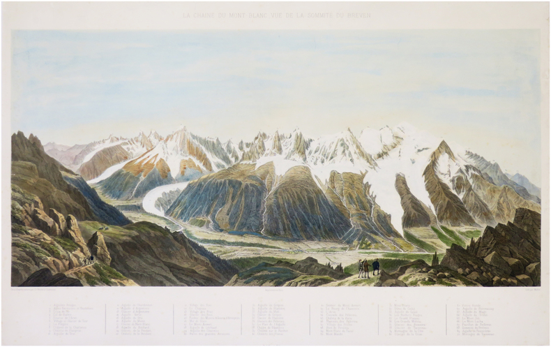
WEIBEL (Charles).
[MONT-BLANC] La chaîne du Mont-Blanc, vue de la sommité du Breven.
1856. 378 x 620 mm.
書籍販売業者の参照番号
: LBW-8113
|
|
|
WEISBUCH (Claude).
Carte de voeux illustrée d'une gravure originale signée.
Paris Société des peintres-graveurs français 1998 1 vol. Broché Carte dépliante sur Arches illustrée d'un beau portrait d'Eugène Delacroix gravé à la pointe-sèche (18 x 14 cm), numéroté 96/240 et signé par Claude Weisbuch. En parfait état.
書籍販売業者の参照番号
: 109084
|
|
|
WEISBUCH (Claude).
Carte de voeux illustrée d'une gravure originale signée.
Paris Société des peintres-graveurs français 1991 1 vol. Broché Carte dépliante sur Arches illustrée d'un beau portrait de Mozart gravé à la pointe-sèche (19 x 14 cm) et signé par Claude Weisbuch. En parfait état.
書籍販売業者の参照番号
: 109085
|
|
|
Weinberg Albert:
Dan Cooper. Sérigraphie originale.
Lausanne, La Marge. Sérigraphie originale au format 25,5 x 17 cm., tirage non mentionné.
書籍販売業者の参照番号
: 6316

|
|
|
Weidinger Otto/Lindner Heinz maps
Division Das Reich im Bild The Reich Division in Photographs
Osnabruck: Munin Verlag GmbH 1987. 3rd edition. VG/VG dust jacket. 287 p. photos maps color map on endpapers 4to DUAL TEXT IN GERMAN AND ENGLISH; Munin Verlag GmbH hardcover
書籍販売業者の参照番号
: 67786 ISBN : 3921242452 9783921242452

|
|
|
Weil Thomas E. & Blackjan Knippers; Townsend Charles; Maps Illustrator
Area Handbook for Peru Hand Book
USGPO. american University 1978-01-01. Revised 2nd pt. Hardcover. Very Good. NICE CONDITION HARDCOVER BOOK. NO WRITING OR MARKINGS IN THE TEXT. ALMOST NO WEAR TO COVER. A CLEAN AND SOLID BOOK. 2ND EDITION. USGPO. american University hardcover
書籍販売業者の参照番号
: R-2295
|
|
|
Weißenburg in Bayern:
Accurater Prospect und Grundris der Gegend der Kayserl. Freyen Reichs-Stadt Weissenburg am Nordgau. Altkolorierter Kupferstich bei J. B. Homann. Kolorierte Landkarte, darin mittig die Stadt Weißenburg, unten mit einer unkolorierten Ansicht, flankiert von 2 Detailansichten.
50 x 59 cm. 50 x 59 cm. *Sauber und sehr gut erhalten. Landkarten de
|
|
|
WELCH Anthony:
Collection of Islamic Art. Prince Sadruddin Aga Khan.
Château de Bellerive, Geneva, [privatly printed], 1972 - 1978. 4 volumes in-4 de 224-[8]; 224-[4]; 218-[4]; 220-[4] pages, reliés en plein maroquin vert, tranches dorées. Reliure d'éditeur.
書籍販売業者の参照番号
: 20179
|
|
|
Wellbye, Reginald and the Staff of 'Cycling'
'Cycling' Book of Tours
No marks or inscriptions to contents. Very minor creasing to some corners. Clean tight pages with very slightly marked dusty boards, rusty staples and no bumping to corners. With eight attached fold-out coloured maps of major tourist areas in Britain and Ireland in very good condition. 84pp. With forty itineraries of 7 to 14 day Tours in England, Scotland, Ireland and Wales, forty sketch maps and eighty illustrations.

|
|
 検索結果のメールを受信する
 PDFファイルの検索結果をダウンロード
 RSSフィード


