|
William Guthrie
Geographical Historical and Commercial Grammar Kingdoms & Maps of the World 1792
1792. leather. Fair. Photo Gallery Original Edition <b>-RARE!-</b> <b>1792 -Thirteenth Edition- </b>Corrected First Edition was about 1770 Publisher-Printing Location: Printed for Charles Dilly etc. London Author: William Guthrie the Astronomical Part by James Ferguson Date: 1792 Size and Page Count: 5.5 X 8.5 Tall; 910 Pages Condition: -Fair- Leather Bound that has <b>ancient repairs</b> with leather on hinge and spine corners heavy wear a few pages have stain spots tears on edges Foxing heavier on front pages; text block Good many fold out maps that extend at their fold past the paper text block that have wear and tears from storage.over 220 years <br /><br />Illustrations Information: <b>15 foldout MAPS and Hundreds of Tables and Charts</b> -------- An excellent opportunity for the collector researcher or historian --------- Articles and <i>Information: Includes: </i><br />Title page <br />advertisement bibliography of changes to each edition up to this one <b>mentions the 13 Colonies</b> <br />Preface6 pages <br />Contents <br />Introduction pages 1 to 58 <br />Body Part 1 astronomical Geography <br />Part II Origin of Laws Government and Commerce <br />Part III Origin and Progress of religion <br />Each Continent divided up into Countries - Title page- A New Geographical Historical and Commercial Grammar and Present State of the Several Kingdoms of the World Containing I. The Figures Motions and Distances of the planets according to the Newtonian System and the latest Observations. II. A general View of the Earth considered as a Planet ; with several useful Geographical Definitions and Problems. III. The grand Divisions of the Globe into Land and Water Continents and Islands. IV. The Situation and Extent of Empires Kingdoms States Provinces and Colonies. V. Their Climates Air Soil vegetable Productions Metals Minerals natural Curiosities Seas Rivers Bays Capes Promontories and Lakes. VI. The Birds and Beads peculiar to each Country. VII. Observations on the Changes that have been any where observed upon the Face of Nature fince the moll early Periods of Hiftory. VIII. The History and Origin of Nations; their Forms of Government Religion Laws Revenues Taxes naval and military Strength. IX. The Genius Manners Customs and Habits of the People. X. Their Language Learning Arts Sciences Manufactures and Commerce. XI. The chief Cities Structures Ruins and artificial Curiosities. XII. The Longitude Latitude Bearings and Distances of principal Places from London. TO WHICH ARE ADDED I. A Geographical Index with the Names and Places alphabetically arranged. II. A Table of the Coins of all Nations and their Value in English Money. III. A Chronological Table of remarkable Events from the Creation to the prefent Time. Maps not in this book: World Sphere Europe West Indies South America North America Foldout MAPS: Denmark Sweden and Norway 61 40% missing Russia in Europe 116 a piece missing Scotland 148 England and Wales 198 Ireland 417 France 445 Germany Netherlands 490 Poland Lithuania and Prussia 537 Switzerland 557 Spain and Portugal 564 Italy 597 Turkey in Durope and Hungary 626 Asia 635 East Indies India etc half missing 678 Africa torn but complete 726 hardcover
Référence libraire : 730

|
|
|
William Seymour with maps & battle plans drawn by W F N Watson
BATTLES IN BRITAIN 1066 - 1547 Volume 1 Narrative accounts of main battles
Sidgwick & Jackson publishers London 1975 hardcover 6�" x 9�" with dust jacket Ours is an ex-library copy in transparent protective covering with usual stamps stickers & barcode etc. GOOD book in GOOD unclipped dust jacket This is an account of all the major battles fought on British soil from 1066 to 1547. It includes 1 Narrative accounts of the main battles 2 An analysis of the historical background and results of battles 3 A guide to all battlefields including road directions; 4 Aerial photographs keyed with the positions of the troops during the battle; 5 Battle-plans specially commissioned for this book; 6 Numerous contemporary illustrations. Sidgwick & Jackson, publishers, London hardcover
Référence libraire : 37061
|
|
|
William Seymour with maps & battle plans drawn by W F N Watson
BATTLES IN BRITAIN 1642 - 1746 Volume 2 Narrative accounts of main battles
Sidgwick & Jackson publishers London 1975 hardcover 6�" x 9�" with dust jacket Ours is an ex-library copy in transparent protective covering with usual stamps stickers & barcode etc. GOOD book in GOOD unclipped dust jacket This is an account of all the major battles fought on British soil from 1642 to 1746. It includes 1 Narrative accounts of the main battles 2 An analysis of the historical background and results of battles 3 A guide to all battlefields including road directions; 4 Aerial photographs keyed with the positions of the troops during the battle; 5 Battle-plans specially commissioned for this book; 6 Numerous contemporary illustrations. A fascinating synopsis of fifteen major conflicts. Sidgwick & Jackson, publishers, London hardcover
Référence libraire : 37041
|
|
|
William Seymour maps drawn by W F N Watson
DECISIVE FACTORS IN TWENTY GREAT BATTLES OF THE WORLD
Sidgwick & Jackson Bloomsbury Way London 1988 Hardcover 16�cms x 24cms 6�" x 9�" with dust jacket VERY GOOD book in VERY GOOD unclipped dust jacket In every battle it is possible to discern one or more factors that have a bearing on the outcome. In this book each battle is set in its historical background with a detailed outline of the action battles included here range from 202BC to 1954 and cover the Battle of Hastings the Saratoga Campaign the Battle of Waterloo The American Civil War the Battle of Warsaw and the Siege of Dien Bien Phu and many others. Clearly written thoroughly researched and illustrated throughout with maps this highly original book provides a convincing insight into the anatomy of victory and defeat. Sidgwick & Jackson, Bloomsbury Way, London hardcover
Référence libraire : 42534
|
|
|
William T. Sherman; Illustrator Maps
Memoirs
Barnes & Noble Books 2005. Paperback. Good. Barnes & Noble Books paperback
Référence libraire : SONG0760773688 ISBN : 0760773688 9780760773680
|
|
|
Williams Kenneth P. and Clark Ray maps
Lincoln Finds A General 2 vols:
Macmillan 1949. Hardcover. Acceptable. Disclaimer:A readable copy. All pages are intact and the cover is intact. Pages can include considerable notes-in pen or highlighter-but the notes cannot obscure the text. The dust jacket is missing. At ThriftBooks our motto is: Read More Spend Less. Macmillan hardcover
Référence libraire : GB002DIOOZYI5N01

|
|
|
Williams Kenneth P. and Clark Ray maps.
Lincoln Finds A General 2 vols:
New York:: Macmillan 1949. Hardcover. Near Fine. 902 pp. 8vo. Hardcovers in slc. 2 vols. 47 military maps - 11 full pg photos by Mathew Brady. Light rubbing & sunning to spines. Bindings sturdy. Light foxing to textblock edges. Textblocks clean & crisp. Slight wear to slc. Macmillan, hardcover
Référence libraire : 162389

|
|
|
Williams Jay. Maps By Richard Edes Harrison
The Battle for the Atlantic. Landmark Books Series No. 87
Random House 1959. Hardcover. Good. Disclaimer:A copy that has been read but remains in clean condition. All pages are intact and the cover is intact. The spine may show signs of wear. Pages can include limited notes and highlighting and the copy can include previous owner inscriptions. At ThriftBooks our motto is: Read More Spend Less.Dust jacket in good condition. Fourth printing. Shelf and handling wear to cover and binding with general signs of previous use. Unclipped dust jacket in protective mylar cover. Secure packaging for safe delivery.Dust jacket quality is not guaranteed. Random House hardcover
Référence libraire : 727925710
|
|
|
Williams Jay. Maps By Richard Edes Harrison
The Battle for the Atlantic. Landmark Books Series No. 87
Random House 1959. Hardcover. Acceptable. Disclaimer:A readable copy. All pages are intact and the cover is intact. Pages can include considerable notes-in pen or highlighter-but the notes cannot obscure the text. The dust jacket is missing. At ThriftBooks our motto is: Read More Spend Less. Random House hardcover
Référence libraire : GB000QXT8LII5N01

|
|
|
Williams County Chapter of the Ohio Genealogical Society. D. J. Lake et al. maps
Williams County Ohio. 1874 1894 Atlases; 1904 Plat Book; 1864 Wall Map Combined.
Bryan Ohio Williams County Chapter O. G. S. 1983. Price HAS BEEN REDUCED by 10% until Monday June 29 sale item small folio leaves 30.5 cm. tall not consecutively paginated but approximately 250 pages; facsimiles of Map of Williams Co. Ohio. Philadelphia: Stone & Titus 1864 An Illustrated Historical Atlas of Williams County Ohio. Chicago: Andreas & Baskin 1874 Atlas of Williams County Ohio. Cleveland: Gordon Lathrop & Co. 1894 Plat Book of Williams County Ohio. Bryan: Democrat Publishing Company 1904; although much reduced from the originals and a glass with be needed by most a clear reproduction; library hand stamps else very good in publishers cloth Bryan (Ohio) Williams County Chapter O. G. S., hardcover
Référence libraire : ZB868940
|
|
|
Willis Bailey. Editor of Geologic Maps
GEOLOGIC ATLAS Of The UNITED STATES. NEVADA CITY SPECIAL FOLIO. CALIFORNIA
Washington D.C.: U.S. Geological Survey. Very Good. 1896. FIRST EDTION FIRST ISSUE. Soft Cover. 21 3/4" x 18 1/2" Department of the Interior. 21 3/4" x 18 1/2". 9 pp. plus 8 color maps in stiff covers. Former staples missing covers soiled margins damp-stained. . U.S. Geological Survey paperback
Référence libraire : 30643
|
|
|
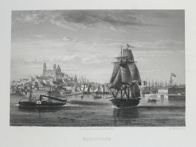
WILLMANN (Edward).
[URUGUAY] Montevideo.
Paris, [circa 1860]. 126 x 168 mm.
Référence libraire : LBW-1233
|
|
|
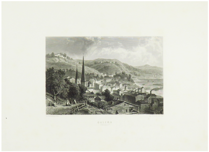
WILLMANN (Edward).
Galena (Illinois).
Paris, [circa 1860]. 131 x 172 mm.
Référence libraire : LBW-1248
|
|
|
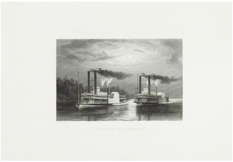
WILLMANN (Edward).
Lutte entre deux steamboats.
Paris, [circa 1860]. 125 x 170 mm.
Référence libraire : LBW-1249
|
|
|
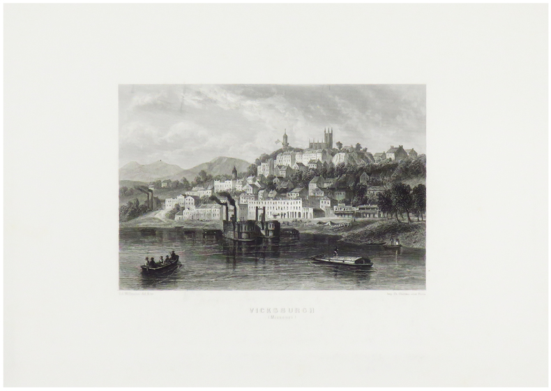
WILLMANN (Edward).
Vicksburgh (Missouri).
Paris, [circa 1860]. 130 x 170 mm.
Référence libraire : LBW-1247
|
|
|
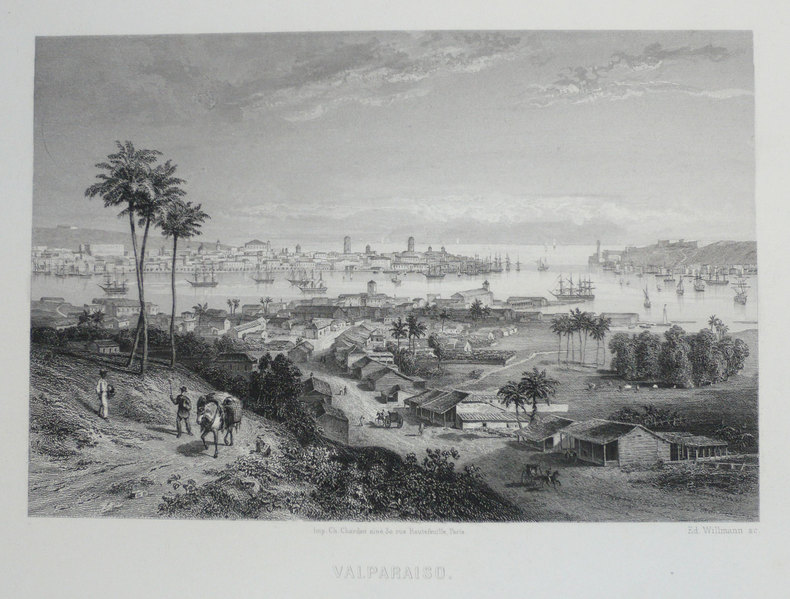
WILLMANN (Edward);
[CHILI] Valparaiso.
Paris circa 1860 126 x 168 mm.
Référence libraire : LBW-1203
|
|
|
WILLOUGBY Martin
"La carte postale; une histoire illustrée du tournant du siècle à nos jours."
Paris, Bookking International, 1993. 23 x 30, 153 pp., très nombreuses illustrations en couleurs, reliure d'édition carton imprimé + jaquette, très bon état.
Référence libraire : 73751 ISBN : 287714173
|
|
|
Wills, F. Alex (The Vagabond)
The English Gate (Northumberland)
No marks or inscriptions. No creasing to covers or to spine. A very clean very tight copy with bright unmarked slightly sunned orange cloth boards, rubbing to a small number of page edges and bumping to lower front corner. 242pp. Historical and touring account of the county of Northumberland. Illustrated. Undated ca 1950.

|
|
|
WILLY PAUL ROMAIN
Assasins de dieu.
Grasset, 1969, etat d'usage, 202 pages avec bandeau, in12.
Référence libraire : 4372
|
|
|
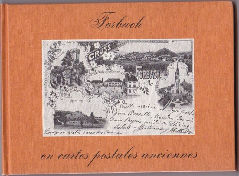
WILMIN H
Forbach En Cartes Postales Anciennes
Pays Bas Bibliotheque Europeenne 1980 In 12 Oblong Non paginé - env. 80 pages - cartonnage editeur illustré - trés nombreuses reproductions de CPA - bel etat
Référence libraire : RES10L74
|
|
|
WILMIN H
Forbach En Cartes Postales Anciennes
Pays Bas Bibliotheque Europeenne 1980 In 12 Oblong Non paginé - env. 80 pages - cartonnage editeur illustré - trés nombreuses reproductions de CPA - bel etat
Référence libraire : RES10L74
|
|
|
Wilson Geoff Text and Classon Bill Maps
FISHING VICTORIA'S COASTLINE
South Croydon: Australian Fishing Network. Fine. 2002. 1st Edition. Paperback. 1865130338 . With colour photographic illustrations and many maps a fine copy. This book is light and postage will be reduced for shipment within Australia. ; 300 x 220mm; 112 pages . Australian Fishing Network paperback
Référence libraire : 20138 ISBN : 1865130338 9781865130330

|
|
|
Wilson John cover illustration and interior maps by Celeste Gagnon
FOUR STEPS TO DEATH
Toronto ON / Tonawanda NY: KCP Fictino / Kids Can Press 2005. Fine. 2005. First Edition. Trade Paperback. 1553377052 . First edition. "It is 1942. The Battle of Stalingrad one of the bloodiest in history is underway. Three participants --- two fighters and a boy --- are caught in its horrors". Pictorial wrappers 207 pages illustrated with maps. Fine copy. . KCP Fictino / Kids Can Press [2005] paperback
Référence libraire : 70998 ISBN : 1553377052 9781553377054

|
|
|
Wilson, H. L. & Clayton Jones, H.
Mountain Skylines and Place Names in Llandudno and District
No marks or inscriptions to contents. No creasing to covers. A clean tight booklet with slightly foxed boards, mark to rear (ink ?), rusty staples and no bumping to corners. 24pp. In three parts - 'Guide to the Welsh pronunciation', 'Mountains in the vicinity of Llandudno' and 'Welsh Place Names in Llandudno and District'. Undated ca 1900.

|
|
|
Wilson, Martin Anthony
Unwind by Water in Lakeland
Book in mint unread condition. 132pp. For those who come to the Lake District to unwind and enjoy some time relaxing in a glorious waterside setting. This book tells you the places to go.

|
|
|
Wilson, Robert H. (Editor).
PHILADELPHIA. Official Handbook for Visitors.
128p. Illustrated with numerous photographs, many in color, and maps. 16mo. Original wraps very soiled. PA PAMPH 20_18 BX6
|
|
|
WILSON, Robert Thomas
History Of The British Expedition To Egypt; To Which Is Subjoined A Sketch Of The Present State Of That Country And Its Means Of Defence; Illustrated With Maps And Portraits of Sir Ralph Abercromby
London: T. Egerton, 1803. in-4° , (270x215) , relié demi basane et coins , dos lisse avec pièce de titre et auteur, xxi-387pp , frontispice , 2 tableaux dépliants et 3 cartes dépliantes légèrement coloriées ,quelques rousseurs , déchirure à une carte sans manque ,ex-libris charles Kettaneh, bon exemplaire .
Référence libraire : PHO-893
|
|
|
Winchester Simon maps and charts by Cezanne Wong Dust Wrapper design by Marc Burckhardt author photo by Garfield Wong
PACIFIC NIGHTMARE: HOW JAPAN STARTS WORLD WAR III A FUTURE HISTORY
New York: A Birch Lane Press Book / Carol Publishing Group 1992. Near Fine in Near Fine dust jacket. 1992. First Edition. Hardcover. 1559721367 . First edition. Near future fiction. 302 pages illustrated with maps including the endpapers index. Near Fine copy light spine end bumping in Near Fine Dust Wrapper very short creased bottom edge tear. . A Birch Lane Press Book / Carol Publishing Group [1992] hardcover
Référence libraire : 70945 ISBN : 1559721367 9781559721363

|
|
|
Winchester Simon; Wong Cezanne Maps & Charts
Pacific Nightmare: A Third World War In The Far East
Sidgwick & Jackson Ltd. Very Good in Very Good dust jacket. 1992. First Edition; First Printing. Hardcover. 0283061065 . Book and DJ have mild edgewear 4 pages have small wrinkle to fore-edge w/tiny tear to 2 of those pages little bit of very light soiling to page ends; DJ has light toning to flaps little bit of wrinkling to edges 2 small faint moisture marks to interior front edge that doesn't show through; DJ in protective Brodart cover ; 302 pages . Sidgwick & Jackson Ltd hardcover
Référence libraire : S1933 ISBN : 0283061065 9780283061066

|
|
|
Winsor, Justin; Boston.
MEMORIAL HISTORY OF BOSTON - INLCLUDING SUFFOLK COUNTY, MASSACHUSETTS. 1630-1880. Four Volume Set.
Four Volumes. pp. 596; 577; 691; 713 + Folded two page map of Boston in color, and other illustrations, maps etc. 4to. Original full cloth binding; somewhat worn and stained. XLib. Skidompha Library, Damriscotta, ME. **PRICE JUST REDUCED! NEW ENG 4
|
|
|
Winston Halstead (editor)
Lancashire Magazine : Autumn 1978
No marks or inscriptions. Light creasing to covers. A very clean very tight copy with bright unmarked boards and no bumping to corners. 71pp. Features on Clitheroe and Gisburn, curious Lancashire, Ferries across the Mersey, fashion, leisure, local history.

|
|
|
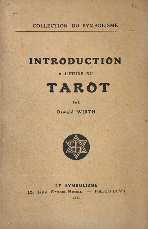
Wirth (Oscar) :
Introduction à l'étude du Tarot.
Paris, Le Symbolisme, 1931 ; in-8, broché ; 49 pp., (3) ff. de table, achevé d'imprimer, le dernier blanc, couverture beige imprimée, nombreuses figures in-texte.
Référence libraire : 14773
|
|
|
WIRTH Thierry
LA PROVENCE LA COTE D'AZUR A LA BELLE EPOQUE
Bruxelles, SODIM, 1976, 1 vol. in-4, reliure d'éditeur illustrée, de 214 reproductionsde cartes postales,
Référence libraire : 10968
|
|
|
Wisconsin State Planning Board & Wisconsin Conservation Commission maps B/W photographs
A Park Parkway and Recreational Area Plan Wisconsin State Planning Board and Conservation Commission
Wisconsin State Planning Board Wisconsin Conservation Commission 1939. Price HAS BEEN REDUCED by 10% until Monday June 29 sale item 134 pp. foldout map rebound in buckram hardcover ex library covers rubbed several pages lightly creased at top corner or fore edge glue residue to front free endpaper else text clean and binding tight Wisconsin State Planning Board, Wisconsin Conservation Commission hardcover
Référence libraire : ZB783545
|
|
|
Wises Maps
Wises Photomaps: Auckland & Gulf
Auckland: Air Logistics NZ Ltd. 1st Edition 1st Printing. Soft cover. Near Fine. Elephant Folio - over 15 - 23" tall. Book is in near new condition with only light shelf wear. Undated. 117pp. Photographic maps of the Auckland region and Auckland Gulf. 0 <br/> <br/> Air Logistics (NZ) Ltd paperback
Référence libraire : 016554 ISBN : 9415803066401 9415803066
|
|
|
Wit Frederick de Pugsley William H. William Howard donor WH. Pugsley Collection of Early Canadian Maps W. H.
Terra Nova ac maris tractus circa Novam Franciam Angliam Belgium Venezuelam Novam Andalusiam Guianam et Brasiliam 1675 Leather Bound
2019. Leather Bound. New. Leather Binding on Spine and Corners with Golden Leaf Printing on round Spine extra customization on request like complete leather Golden Screen printing in Front Color Leather Colored book etc. Reprinted in 2019 with the help of original edition published long back 1675. This book is printed in black & white sewing binding for longer life Printed on high quality Paper re-sized as per Current standards professionally processed without changing its contents. As these are old books we processed each page manually and make them readable but in some cases some pages which are blur or missing or black spots. If it is multi volume set then it is only single volume if you wish to order a specific or all the volumes you may contact us. We expect that you will understand our compulsion in these books. We found this book important for the readers who want to know more about our old treasure so we brought it back to the shelves. Hope you will like it and give your comments and suggestions. Lang: - latdut. EXTRA 10 DAYS APART FROM THE NORMAL SHIPPING PERIOD WILL BE REQUIRED FOR LEATHER BOUND BOOKS. COMPLETE LEATHER WILL COST YOU EXTRA US$ 25 APART FROM THE LEATHER BOUND BOOKS. hardcover
Référence libraire : LB1111007010814
|
|
|
Wit Frederick de Pugsley William H. William Howard donor WH. Pugsley Collection of Early Canadian Maps W. H.
Terra Nova ac maris tractus circa Novam Franciam Angliam Belgium Venezuelam Novam Andalusiam Guianam et Brasiliam 1675 FULL LEATHER BOUND
2019. SUPER DELUXE EDITION. New. Antique look with Golden Leaf Printing and embossing with round Spine completely handmade bindingextra customization on request like Color Leather Colored book special gold leaf printing etc. Reprinted in 2019 with the help of original edition published long back 1675. This book is printed in black & white sewing binding for longer life Printed on high quality Paper re-sized as per Current standards professionally processed without changing its contents. As these are old books we processed each page manually and make them readable but in some cases some pages which are blur or missing or black spots. If it is multi volume set then it is only single volume if you wish to order a specific or all the volumes you may contact us. We expect that you will understand our compulsion in these books. We found this book important for the readers who want to know more about our old treasure in old look so we brought it back to the shelves. Hope you will like it and give your comments and suggestions. Lang: - latdut. EXTRA 10 DAYS APART FROM THE NORMAL SHIPPING PERIOD WILL BE REQUIRED. Normal Hardbound Edition is also available on request. unknown
Référence libraire : SD1111007010814
|
|
|
Wit Frederick de Pugsley William H. William Howard donor WH. Pugsley Collection of Early Canadian Maps W. H.
Terra Nova ac maris tractus circa Novam Franciam Angliam Belgium Venezuelam Novam Andalusiam Guianam et Brasiliam 1675
2019. Paperback. New. Lang: - latdut. Reprinted in 2019 with the help of original edition published long back 1675. This book is Printed in black & white sewing binding for longer life with Matt laminated multi-Colour Soft Cover HARDCOVER EDITION IS ALSO AVAILABLE Printed on high quality Paper re-sized as per Current standards professionally processed without changing its contents. As these are old books we processed each page manually and make them readable but in some cases some pages which are blur or missing or black spots. If it is multi volume set then it is only single volume if you wish to order a specific or all the volumes you may contact us. We expect that you will understand our compulsion in these books. We found this book important for the readers who want to know more about our old treasure so we brought it back to the shelves. Any type of Customisation is possible with extra charges. Hope you will like it and give your comments and suggestions. paperback
Référence libraire : PB1111007010814
|
|
|
Wit Frederick de Pugsley William H. William Howard donor WH. Pugsley Collection of Early Canadian Maps W. H.
Terra Nova ac maris tractus circa Novam Franciam Angliam Belgium Venezuelam Novam Andalusiam Guianam et Brasiliam 1675 Hardcover
2019. Hardcover. New. Lang: - latdut. Reprinted in 2019 with the help of original edition published long back 1675. This book is Printed in black & white Hardcover sewing binding for longer life with Matt laminated multi-Colour Dust Cover Printed on high quality Paper re-sized as per Current standards professionally processed without changing its contents. As these are old books we processed each page manually and make them readable but in some cases some pages which are blur or missing or black spots. If it is multi volume set then it is only single volume if you wish to order a specific or all the volumes you may contact us. We expect that you will understand our compulsion in these books. We found this book important for the readers who want to know more about our old treasure so we brought it back to the shelves. Any type of Customisation is possible with extra charges. Hope you will like it and give your comments and suggestions. hardcover
Référence libraire : 1111007010814
|
|
|
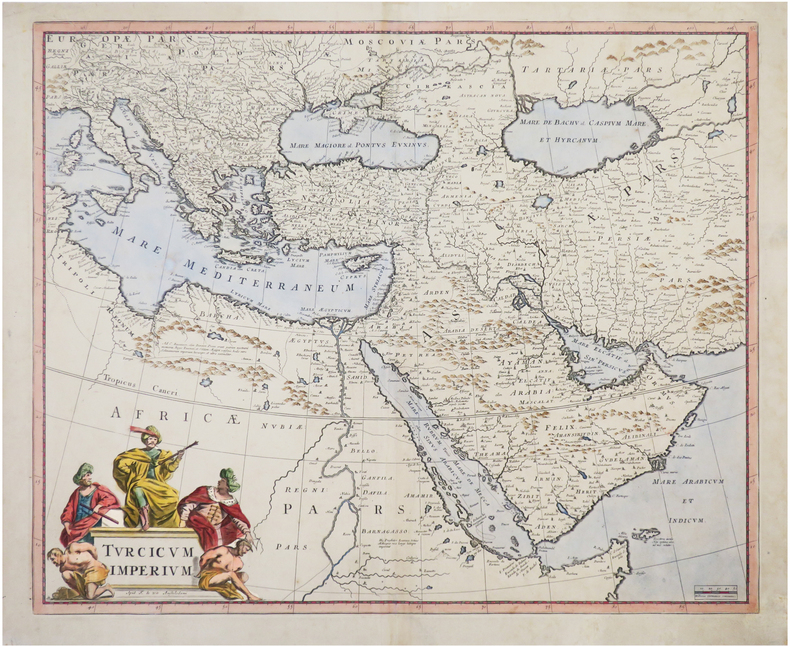
WIT (Frederick de).
[EMPIRE OTTOMAN] Turcicum Imperium.
Amsterdam, F. de Wit, [circa 1680]. 454 x 557 mm.
Référence libraire : LBW-8054
|
|
|
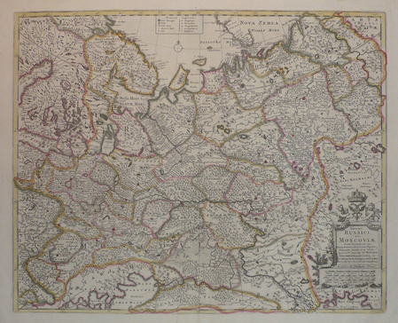
WIT (Frederick de).
[RUSSIE] Imperii Russici, sive Moscoviae.
London, Christopher Browne, [circa 1700]. 450 x 558 mm.
Référence libraire : LBW04171
|
|
|
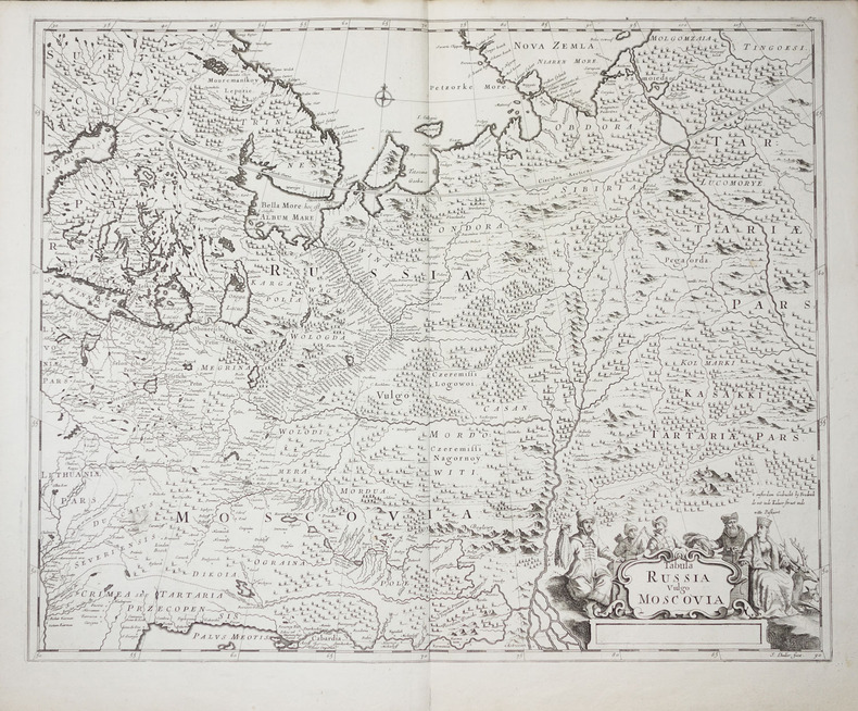
WIT (Frederick de).
Tabula Russia vulgo Moscovia.
vers 1700. 450 x 558 mm.
Référence libraire : LBW-2278
|
|
|
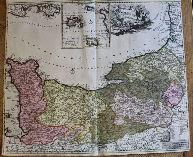
WITT (F. De).
Duché et Gouvernement de Normandie divisé en Haut et Bas en divers Pays et Bailliages avec le Gouvernement General de Havre de Grace.
Amsterdam, F. De Witt avec Privilège des Etats d'Hollandeet de Westfrise, s.d. (ca 1700-1708). Carte de 600 x 525 mm. Baillages mis en couleurs et cartouche central avec les îles anglo-normandes Garnezy, Ierzay et Aurigny. En très bon état, sans marges latérales
Référence libraire : 22401
|
|
|
Wittemberg:
Wittemberg. "Plan der Action, welche d. 2.Oct. 1760 zwischen einem Kön. Preussischen Corps und einem Corps der Kayseerlichen und Reichs Armee bey Wittemberg vorgefallen." Schlachtenplan von Wittemberg, links mit Legende. Kupferstich mit farbigen Truppenaufstellungen aus "Neues Kriegs-Theater ...", 23. Supplement.
Format: 18 x 29,5 cm. *Leicht gebräunt, insgesamt gut erhalten. Landkarten de
|
|
|
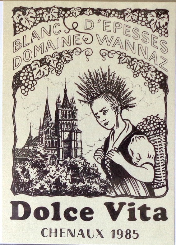
Witzig Roland:
Dolce Vita - étiquette de vin.
Etiquette pour un blanc d'Epesses, domaine Wannaz à Chenaux, 1985.
Référence libraire : 1901
|
|
|
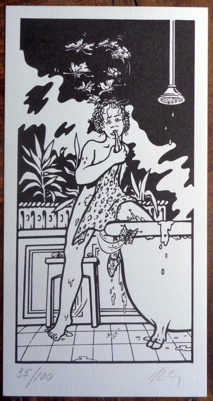
Witzig Roland:
Petite sérigraphie en noir, sans titre.
Petite sérigraphie au format 11 x 21 cm.
Référence libraire : 985
|
|
|
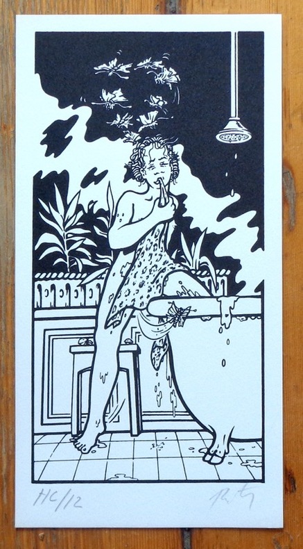
Witzig Roland:
Witzig - Petite sérigraphie signée.
Lausanne, La Marge. Sérigraphie en noir, au format 11 x 21 cm.
Référence libraire : 6308
|
|
|
Witzleben, A. von
Deutschlands Militär-Literatur im letzten Jahrzehnt und Übersicht der wichtigsten Karten und Pläne Central-Europas.
Bln., Mittler 1850. VII, 247 S., HLn. m. gldgepr. Rückentit., Kanten leicht bvestoß., Bibl.-Stemp. u. hs. Vermerk am Innentit., schwach stockfl.
Référence libraire : BIBG0021
|
|
|
WO Hotchkiss; Illustrator charts photos. fold out maps
Mineral Land Classification.showing indications of Iron Formation in parts of Ashland Bayfield Washburn.
State of Wisconsin 1/1/1915. Hardcover. Acceptable. FAIR CONDITION THICK HARDCOVER BOOK. NO WRITING OR MARKINGS IN TEXT. OWNER SIGNATURE ON FRONT ENDPAPER. HINGES CRACKED AND LOOSE. WEAR AND FRAYING TO COVERS. State of Wisconsin hardcover
Référence libraire : SKU-98157
|
|
|
Woerl, Joseph Edmund [1803-1865]:
Die Badischen Bäder. Baden, Rippoldsau, Griesbach, Hub, Petersthal, Erlenbad, Antogast, Freiersbach etc. oder Specialkarte der Gegend zwischen Strassburg, Carlsruhe, Offenburg und Freudenstadt. Maßstab 1 : 135 000.
Lithographierte Karte, auf Leinen aufgezogen in 15 Segmenten. 55 x 48 cm, gefaltet: 17 x 12 cm. In Orig.-Halbleinenmappe. *Datierung nach den Angaben zu dem Exemplar der Universitätsbibliothek Basel. Landkarten de
|
|
 Recevoir par e-mail
 Télécharger en PDF
 Flux RSS


