|
ATLAS MIGEON
Carte d?partementale couleurs : Loire. Fin XIXe.
Feuille 34 x 26 cm.
|
|
|
ATLAS MIGEON
Carte d?partementale couleurs : Loiret. Fin XIXe.
1 feuille 25x33 cm.
|
|
|
ATLAS MIGEON
Carte d?partementale couleurs : Ni?vre. Fin XIXe.
1 feuille 36 x 42 cm.
|
|
|
ATLAS MIGEON
Carte d?partementale de la Haute-Loire. Fin XIXe.
Une feuille 26x34 cm.
|
|
|
ATLAS MIGEON
Carte d?partementale en couleurs : Pyr?n?es-Orientales. Fin XIXe.
Une feuille 25x33 cm.
|
|
|
ATLAS MIGEON
Carte d?partementale en couleurs de l'Ard?che. Fin XIXe.
Une feuille 25x33 cm.
|
|
|
ATLAS MIGEON
Carte d?partementale en couleurs de la Haute-Garonne. Fin XIXe.
Une feuille 26x34 cm.
|
|
|
ATLAS MIGEON
Cartes d?partementales couleurs : Is?re. Fin XIXe.
1 feuille 26 x 34 cm.
|
|
|
ATLAS NATIONAL
Vend?e. Notice historique et g?ographique. Gravure couleurs du d?partement. Fin XIXe.
4 pages.
|
|
|
ATLAS PILON - LE VASSEUR
Carte d?partementale couleurs : Ain. Fin XIXe.
Feuille 36x46 cm.
|
|
|
ATLAS PILON - LE VASSEUR
Carte d?partementale couleurs : Dr?me. Fin XIXe.
1 feuille. 36X42 cm.
|
|
|
ATLAS PILON - LE VASSEUR
Carte d?partementale couleurs : Gard. Fin XIXe.
1 feuille 36x46 cm.
|
|
|
ATLAS PILON - LE VASSEUR
Carte d?partementale couleurs : Haute Sa?ne. Fin XIXe.
1 feuille. 36x42 cm.
|
|
|
ATLAS PILON - LE VASSEUR
Carte d?partementale couleurs : Is?re. Fin XIXe.
1 feuille. 36X42 cm.
|
|
|
ATLAS PILON - LE VASSEUR
Carte d?partementale couleurs : Jura. Fin XIXe.
1 feuille. 36x42 cm.
|
|
|
ATLAS PILON - LE VASSEUR
Carte d?partementale couleurs : Loiret. Fin XIXe.
1 feuille 36x42 cm.
|
|
|
ATLAS PILON - LE VASSEUR
Carte d?partementale couleurs : Rh?ne. Fin XIXe.
Feuille 36x46 cm.
|
|
|
ATLAS PILON - LE VASSEUR
Carte d?partementale couleurs : Sa?ne et Loire. Fin XIXe.
1 feuille. 36x42 cm.
|
|
|
ATLAS PILON - LE VASSEUR
Carte d?partementale couleurs : Tarn Fin XIXe.
1 feuille 36x46 cm.
|
|
|
ATLAS PILON - LE VASSEUR
Carte d?partementale couleurs :Indre et Loire. Fin XIXe.
1 feuille 36x42 cm.
|
|
|
ATLAS.
Atlas Portátil, arreglado y traducido de la 41ª edición alemana de H. Habenicht, por Br. Domann. Con noticias geográfico-estadísticas por H. Wichmann y la colaboración de Don José Romagosa.
Gotha, Instituto Geográfico de Justus Perthes, 1906. 8vo. alargado; 36 pp. y 28 mapas dobles grabados en cobre y coloreados. Encuadernación original en tela estampada.

|
|
|
ATLAS.
Atlas Portátil, arreglado y traducido de la edición alemana de H. Habenicht, por Br. Domann. Con noticias geográfico-estadísticas por H. Wichmann y la colaboración de Don José Romagosa.
Gotha - Madrid, Instituto Geográfico de Justus Perthes, Füssel Hermanos, 1904. 8vo. alargado; 36 pp. y 28 mapas dobles grabados en cobre y coloreados. Encuadernación original en tela estampada, fatigada. El mundo en la mano, tal como era poco antes de la Guerra Europea, WWI.

|
|
|
ATLAS.
Nuevo Atlas de España.
Madrid, Aguilar, 1961. Folio; 455 pp. Mapas, gráficos y fotografías. Encuadernación original en tela, ligeramente fatigada.

|
|
|
Attenborough D. and color photos Drawings Maps
The Atlas Of The Living World
Hardcover. Fine. First Edition First Printing. The former owner's name is written on first page which could easily be covered with a new bookplate. Overall excellent condition with crisp clean covers and pages and tight binding with very slight shelf wear. hardcover
Referentie van de boekhandelaar : 18-L56Y-ZWG1 ISBN : 0297796429 9780297796428
|
|
|
Atwood E. Bagby; Maps Linguistic
A Survey of Verb Forms In The Eastern United States
University of Michigan Press. Good. 1953. Hardcover. Exlibrary usual markings. Cover Wear. ; 53 pages . University of Michigan Press hardcover
Referentie van de boekhandelaar : 805734
|
|
|
AUBIER Catherine
Astrologie chinoise.
Paris, M.A. Editions, 1982. 16 x 24, 255 pp., très nombreux dessins, broché, bon état (2 cachets privés).
Referentie van de boekhandelaar : 35142
|
|
|
AUBIN Eugène:
En Haïti, planteurs d'autrefois, nègres d'aujourd'hui.
Paris, Armand Colin, 1910. Fort in-8 de [4]- XXXV- 348 pages, demi-veau blond, dos à nerfs, pièce de titre en maroquin grenat et celle de tomaison en maroquin fauve.
Referentie van de boekhandelaar : 17526
|
|
|
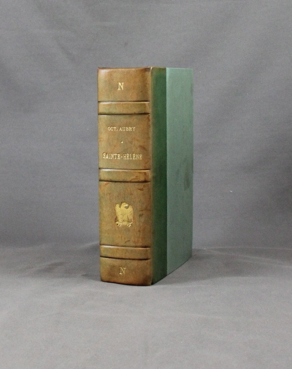
AUBRY Octave:
Sainte-Hélène. Tome 1: La captivité de Napoléon -Tome 2: La mort de l'Empereur.
Paris, Flammarion, 1935. 2 tomes en 1 volume in-8 de XVI-315-335-[2] pages, demi-basane verte, dos à nerfs orné de l’aigle impérial. Dos passé.
Referentie van de boekhandelaar : 1777
|
|
|
AUDE
Carte d?partementale couleurs au 1/200 000?me. Sans date.
Une feuille. 56x76 cm.
|
|
|
AUGSBOURG Géa; SIMENON Georges (préf.):
12 dessins.
Lausanne, éditions EDIP, 1968. In-4 à l'italienne en [12] feuillets sous chemise à un rabats sur lequel se trouve l'achevé d'imprimer. Fac-similé d'une lettre de Simenon au second plat, premier plat orné d'un fac-similé de Géa Augsbourg.
Referentie van de boekhandelaar : 11477

|
|
|
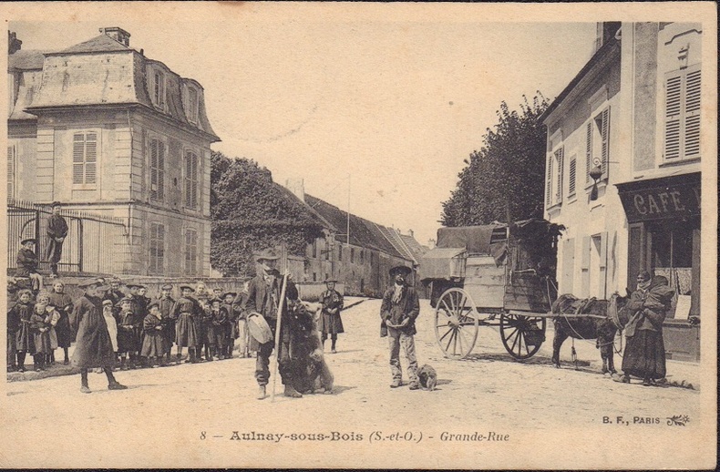
AULNAY-SOUS-BOIS.-
Montreur d'ours dans la grande rue.-
Paris. B. F. 1906 (date de l'oblitération). Carte postale en noir et blanc montrant le montreur d'ours avec, au second plan, un autre personnage et la roulotte avec une femme et un mulet. Écriture et adresse au verso. Bon état. Photo sur demande.
Referentie van de boekhandelaar : ORD-17390
|
|
|
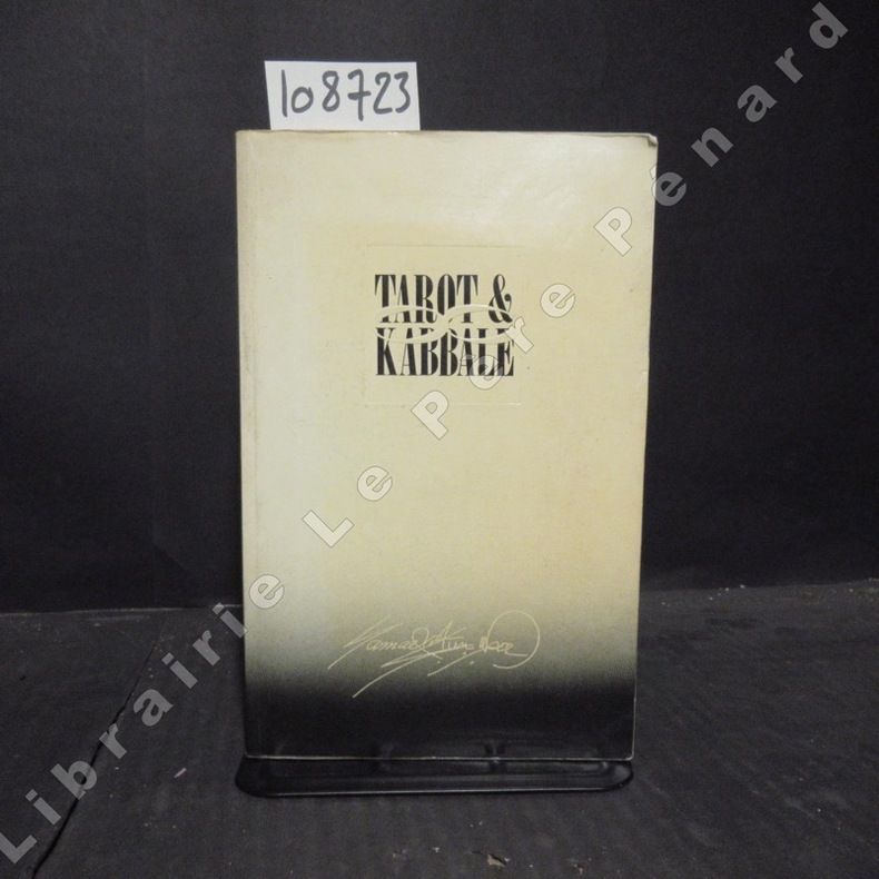
AUN WEOR, Samaël (Victor Manuel Gomez Rodriguez)
Tarot & Kabbale
1988 Editions Thoth - 1988 - In-8, broché - 406 p. - Quelques illustrations in-texte en N&B
Referentie van de boekhandelaar : 108723
|
|
|
AUSCHER (Jean); ROMAINS (Jules)
Le Baccara
Paris, Galerie Noblesse de l'art, s.d. In-folio, [2] ff. 10 pl., en feuilles, couverture originale imprimée (couverture défraîchie, justification manquante).
Referentie van de boekhandelaar : 18534
|
|
|
Aust Albert Hrsg..
Die Elbkarte des Melchior Lorichs vom Jahre 1568. Gekürzte und vollständig umgearbeitete Auflage des 1847 erschienenen Werkes von Johann Martin Lappenberg.
Hamburg 1927. . Möller/Tecke I 443. - Der Hrsg. war Inhaber der Hamburg-Stade-Altländer Linie. - Rücken wenig verblaßt. Gutes Exemplar. Hamburg, 1927. unknown
Referentie van de boekhandelaar : 30692
|
|
|
AUSTRALIA TAA ROUTE MAPS
Maps of TAA Inter-Capital Routes.
Melbourne.: Trans Australia Airlines. No date. Ca. 1950s. Booklet 8 x 4 inches; five double page color pictographic route maps unpaginated 12 pp including covers color pictorial wrappers. Very good condition. Booklet features double page color pictorial route maps descriptive text in lower margin. Maps have small illustrations and text banners indicating the products of various regions. Routes shown are: Sydney-Melbourne; Brisbane-Sydney; Adelaide-Melbourne; Perth-Adelaide; Melbourne-Hobart. Information on the rear cover of the booklet discusses Navigational Aids. . Trans Australia Airlines. unknown
Referentie van de boekhandelaar : 52031

|
|
|
AUSTRALIA - JAMES WYLD.
Map of South Australia, New South Wales, Van Diemens Land, and Settled parts of Australia. Respectfully dedicated to Major Sir T.L. Mitchell.
(London), JAs (James) Wyld, (around 1850). (62,5 x 94 cm.). Engraved map, with original outline colourung.. A few small tears in margins, not affecting image.
Referentie van de boekhandelaar : 44333
|
|
|
AUSTRALIA - JAMES WYLD.
Map of South Australia, New South Wales, Van Diemens Land, and Settled parts of Australia. Respectfully dedicated to Major Sir T.L. Mitchell.
(London), JAs (James) Wyld, (around 1850). (62,5 x 94 cm.). Engraved map, with original outline colourung.. A few small tears in margins, not affecting image.
|
|
|
auteur inconnu
ACADEMIE DES JEUX DE SOCIETE
1840 plaquette éditeur petit in-octavo, couverture jaune illustrée en noir sur le verso, long papier, illustrations : frontispice, très rares et très légères piqûres, 107 pages, 1840 environ Paris .J. Moronval Imprimeur-Libraire Editeur,
Referentie van de boekhandelaar : 66
|
|
|
auteur inconnu
CARTE MICHELIN de la FRANCE ( En 48 FEUILLES ) PARIS (SUD)
Clermont-Ferrand Michelin et Compagnie 1912 -in-8 carte sur papier en couleurs légèrement défraîchie, pliée in-octavo, dépliée in-plano, Sans Date ( Vers 1912 ) Clermont-Ferrand Michelin et Compagnie Propriétaires-Editeurs,
Referentie van de boekhandelaar : 24601
|
|
|
auteur inconnu
CARTE MICHELIN de la FRANCE (NORD)( En 48 FEUILLES )N°10 EVREUX - 1ére SERIE - 7ème EDITION MAI 1924 (4296)
Clermont-Ferrand Michelin et Compagnie 1924 -in-8 carte sur papier en couleurs légèrement défraîchie, pliée in-octavo, dépliée in-plano, Sans Date ( 1924 ) Clermont-Ferrand Michelin et Compagnie Propriétaires-Editeurs,
Referentie van de boekhandelaar : 25587
|
|
|
auteur inconnu
CARTE MICHELIN de la FRANCE (NORD)( En 48 FEUILLES )N°41 DIGNE-NICE - 1ére SERIE - 3ème EDITION 1919 (2160)
Clermont-Ferrand Michelin et Compagnie 1912 -in-8 carte sur papier en couleurs légèrement défraîchie, pliée in-octavo, dépliée in-plano, Sans Date ( 1919 ) Clermont-Ferrand Michelin et Compagnie Propriétaires-Editeurs,
Referentie van de boekhandelaar : 25588
|
|
|
auteur inconnu
L'ART DE TIRER LES CARTES suivi de nombreuses réussites - 1894 -
Paris Vermot 1894 -in-12 broché un volume, broché crème in-douze Editeur (paperback in-12 Editor) (18 x 12,5 cm), dos imprimé en noir, 1ère de couverture imprimée en noir et rouge et illustrée en couleur, Edition ornée de trés nombreuses figures in-texte en noir, quelques plis à la couverture, mais bel état de l'ensemble, 128 pages, sans date (1894) Paris : Vermot Editeur,
Referentie van de boekhandelaar : 24668
|
|
|
auteur inconnu
THE MAGIC BOOK master the mysteries of over 150 magic tricks
1997 reliure pleine toile bleue in-quarto, titre frappé or sur le dos, illustrations photographiques en couleurs, 224 pages, 1997 London Apple Press,
Referentie van de boekhandelaar : 5255
|
|
|
auteur inconnu
TRAITE DE LA BELOTE
1950 plaquette petit in-octavo, dos muet rose, couverture ornée d'une petite illustration, 32 pages, sans date (les années 1930-40 environ) Paris Editions JLR,
Referentie van de boekhandelaar : 6802
|
|
|
Author Not Stated
"Hawaiian Islands and Hayti (or San Domingo)" - 2 Map Plates in Colour Circa 1902
Outside dimensions 14.5" x 10.5" Circa 1902. Centerfold. Light wear. Please see our photo for details. Book

|
|
|
Author Not Stated
(Michigan) County Maps, Region II (Two), Northern Lower Peninsula,
35 pages including 34 maps. Oblong 14" x 18". "This collection of county maps presents in detail basic geographical features of the northern lower peninsula. Also, it includes all types of roads, federal and state-owned lands, state and local parks, camp grounds, fishing sites, and other public recreational facilities." - from title page. Includes the following counties: Emmet, Cheboygan, Presque Isle, Charlevoix, Antrim, Otsego, Montmorency, Alpena, Leelanau, Benzie, Grand Traverse, Kalkaska, Crawford, Oscoda, Alcona, Manistec, Wexford, Missaukee, Roscommon, Ogemaw, Iosco, Mason, Lake, Osceola, Clare, Gladwin, Arenac, Oceana, Newaygo, Muskegon, Mecosta, Isabella, Midland, Bay. Average wear. Unmarked. Maps clean and bright. A sound copy. Book

|
|
|
Author Not Stated
(Michigan) County Maps, Upper Peninsula, Region 1 (One)
31 pages including 30 maps. Oblong 14" x 18". "This collection of county maps presents in detail basic geographical features of the upper peninsula. Also, it includes all types of roads, federal and state-owned lands, state and local parks, camp grounds, fishing sites, and other public recreational facilities." - from title page. Includes the following counties: Gogebic, Ontonagon, Houghton, Keweenaw, Baraga, Iron, Marquette, Dickinson, Menomnee, Delta, Alger, Schoolcraft, Luce, Mackinac, Chippewa. Moderate wear. Minor external soiling. Maps clean and bright. A quality copy. Book

|
|
|
Author Not Stated
1895 Colour Map of the Main Portion of Buffalo, New York - Rand McNally & Co.
Outside dimensions 14.5" x 10.5". Circa 1902. Includes railroads and street car lines. Centerfold. Light wear. Please see our photo for details. Book

|
|
|
Author Not Stated
1899 Colour Map of the Dominion of Canada and Newfoundland
Outside dimensions 14.5" x 10.5" Circa 1902. Centerfold. Light wear. Please see our photo for details. Book

|
|
|
Author Not Stated
1901 Colour Map of the State of Minnesota
Outside dimensions 14.5" x 10.5" Circa 1902. Centerfold. Light wear. Please see our photo for details. Book

|
|
 De zoekresultaten per email ontvangen
 Zoekresultaten downloaden als PDF
 RSS feed


