|
BEAUTEMPS-BEAUPRÉ (Charles-François) & DÉPÔT des CARTES et PLANS de la MARINE.
[RAZ et ÎLE de SEIN] Carte particulière des côtes de France. Chaussée de Sein et passage du Raz de Sein.
Dépôt des Cartes et Plans de la Marine, 1877-1888. 630 x 952 mm.
Référence libraire : LBW-5765

|
|
|
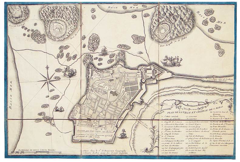
BEAURAIN (Jean de).
[SAINT-MALO] Plan de la ville et château de S. Malo.
Paris, Sr. de Beaurain, [circa 1730]. En 6 sections montées sur toile bordée de soie bleue et pliées, formant un plan de 284 x 420 mm.
Référence libraire : LBW-4015
|
|
|
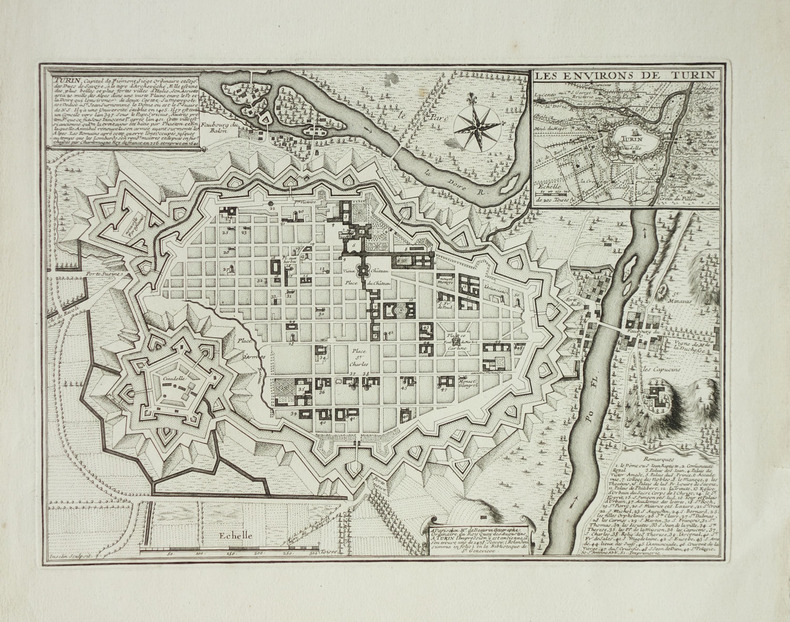
BEAURAIN (Jean de).
[TURIN] Turin, capital de Piémont.
Paris, Mr. de Beaurain, vers 1750. 250 x 343 mm.
Référence libraire : LBW-1902
|
|
|
BEAURAIN (Jean de).
[TURIN] Veüe de la ville de Turin et ses environs dessinée sur les lieux du costé de la montagne au dessus de la vigne de Madame la Princesse.
Paris, Mr. de Beaurin, [circa 1730]. 243 x 330 mm.
Référence libraire : LBW-3493

|
|
|
BEAURAIN (Jean de).
[ÎLES ANGLO-NORMANDES] Carte topo-hidro-graphique des isles d'Aurigny, de Burhou et des Casquets, appartenantes aux Anglois, levées sur les lieux par ordre de la Cour angloise.
Paris, le Chevalier de Beaurain, 1757. 390 x 685 mm.
Référence libraire : LBW-2861

|
|
|
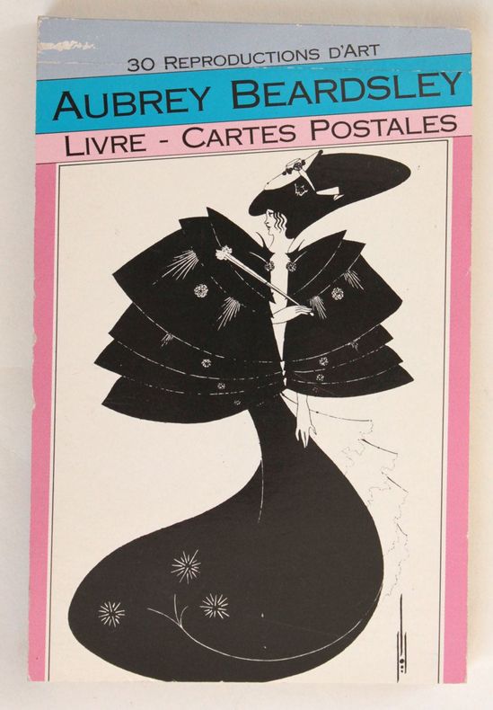
Beardsley, Aubrey
Aubrey Beardsley : Livre - cartes postales, 30 reproductions d'art
Paris Bookking international 1990 in-16 broché Paris, Bookking international, 1990. 16 x 10,5 cm, 2 ff. n. ch. - 30 cartes postales détachables en noir, broché sous couverture illustrée.
Référence libraire : 3191
|
|
|
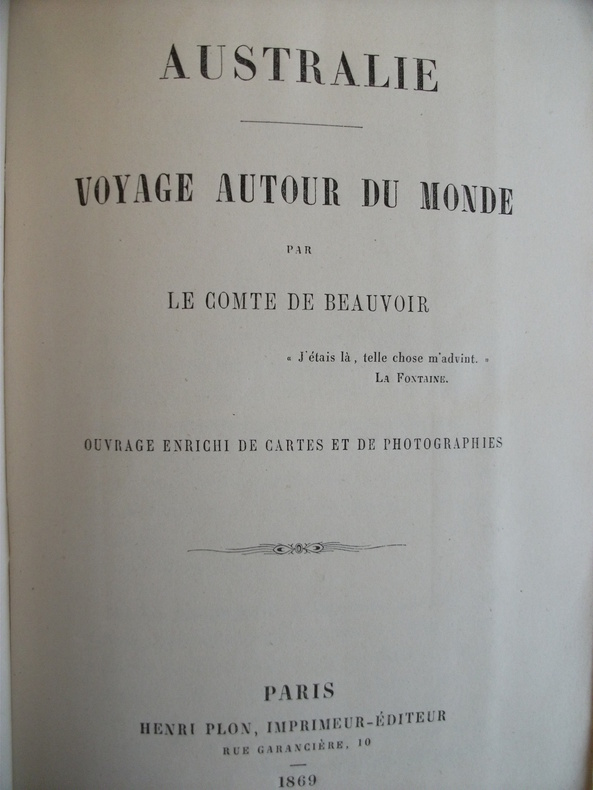
BEAUVOIR Comte (de)
AUSTRALIE voyage autour du monde.
In 12 broché,faux-titre photographie originale d’un aborigène,sous serpente,en frontispice,titre,X,une carte dépliante,en couleurs,360 pages 1feuillet de table.Une deuxième carte dépliante en couleurs en regard de la page 150.une deuxième photos originale d’un aborigène,sous serpente, en regard de la page 172.Henri PLON 1869.petits défauts au dos.Edition peu courante avec ses deux photos originales d’aborigène
Référence libraire : 4014
|
|
|
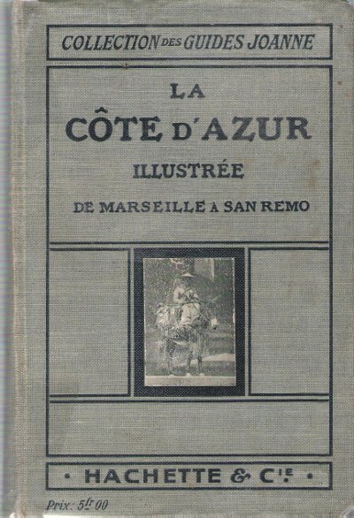
BEAUVAIS Gaston
La Côte d'Azur Illustrée de Marseille à San Remo
Paris Hachette & Cie 1913 In 16 Collection " Des Guides-Joanne " avec 60 gravures , 16 plans et 29 cartes en couleurs dont certaines dépliantes . Nombreuses publicités , notamment d'hôtels mais aussi de Michelin , de chocolat Menier etc . Illustré de photographies en noir et blanc .- 236 p. + 88 p.+ 156 p. , 600 gr.
Référence libraire : 015240
|
|
|
BEAUBOURG].
Le Centre Beaubourg.
Paris Ministère des affaires culturelles, Ministère de l'éducation nationale 1971 1 vol. en feuilles in-4 oblong dépliant formant une affiche 50 x 70 cm. Publication annonçant le choix du projet de Piano, Rogers et Franchini pour la création du Centre Beaubourg, avec une photographie de la maquette et un grand plan en couleurs du bâtiment.
Référence libraire : 90934
|
|
|
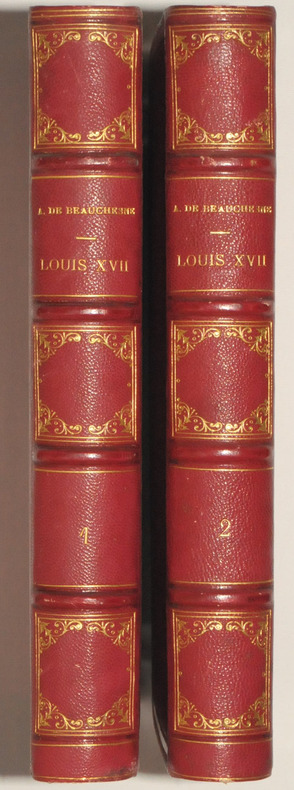
BEAUCHESNE A de.
LOUIS XVII. Sa vie, - Son agonie. - Sa mort. Captivité de la Famille Royale au Temple. Quatrième édition, enrichie d'autographes et de plans ornée de portraits gravés en taille-douce sous la direction de M. Henriquel Dupont et précédée d'une Lettre de Mgr Dupanloup évêque d'Orléans.
Paris, Henri Plon, 1867. 2 volumes grands in-8, 613 et 532 pp, plus table des matière dans chaque volume et placement des gravures et des autographes. Demi-chagrin rouge, dos à 4 nerfs, caissons ornés et filets dorés, tranches dorées. Belle reliure.
Référence libraire : 24447
|
|
|
BEAURAIN (Jean, chevalier de).
Plan de Strasbourg, ville capitale de la province d'Alsace.
Paris, Mr. de Beaurin, 1741. 263 x 338 mm.
Référence libraire : LBW-429
|
|
|
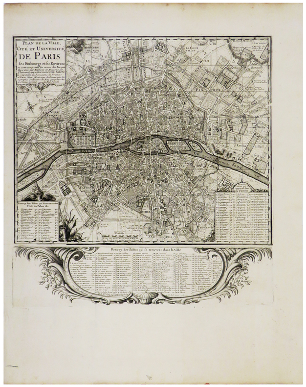
BEAURAIN (Jean de).
Plan de la ville, cité, et université, de Paris ses faubourgs et ses environs.
Paris, Monsieur de Beaurain, [circa 1720]. 299 x 296 mm.
Référence libraire : LBW-3471
|
|
|
Beausacq Comte de
Premières leçons de bridge
Bornemann S. Broché 1935 In-12 (13,5 x 17,9 cm), broché, 56 pages ; ensemble bruni, coiffe inférieure usée, par ailleurs bon état général. Livraison a domicile (La Poste) ou en Mondial Relay sur simple demande.
Référence libraire : fy751
|
|
|
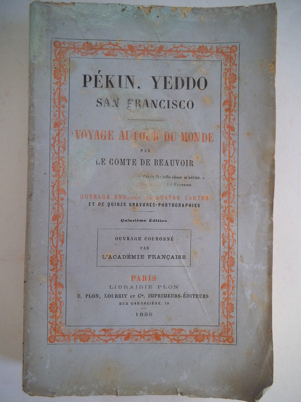
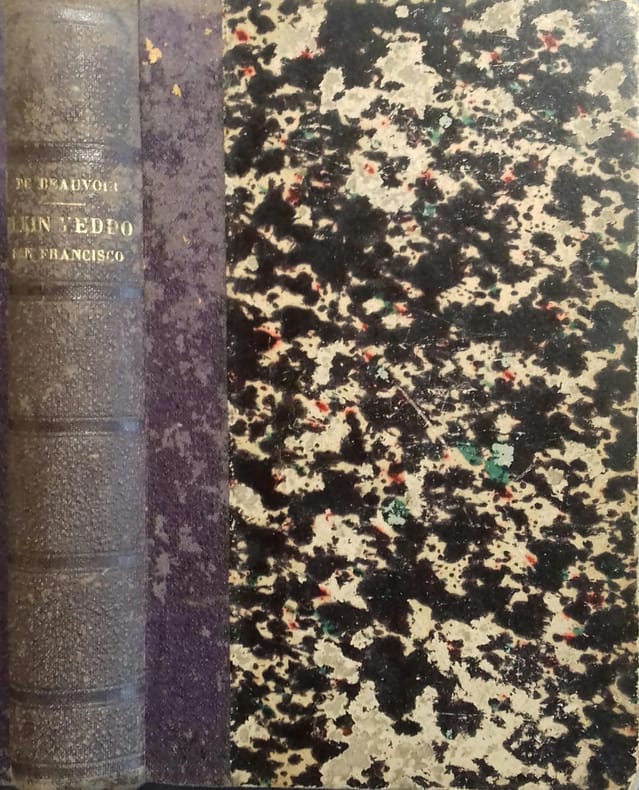
BEAUVOIR Le Comte de
Pékin, Yeddo, San Francisco. Voyage autour du monde
in 12 broché, faux-titre, frontispice sur double page, titre, 335 pages, quatre cartes en couleurs, sur double page, 15 gravures-photographies, certaines sur double page, dont le frontispice, 2 pages de table. Paris Librairie Plon Nourrit& Cie 1888. Dos frotté avec titre et références pratiquement illisibles. A signaler: taches brun clair en demi-cercle dans la marge supérieure du frontispice, une tache brun clair dans la marge supérieure de l’illustration en regard de la page 50, une pâle mouillure en marge extérieure de l’illustration en regard de la page 244. Une mouillure en demi-cercle en marge supérieure de l’illustration en regard de la page 313
Référence libraire : 8922
|
|
|
BEAUVOIR (Comte de) 4 cartes et 15 gravures.
Pékin, Yeddo, San Francisco. Voyage autour du monde par le Comte de Beauvoir.
Couverture souple. Reliure demi-toile. 359 pages.
Référence libraire : 140134
|
|
|
BEANS, George H
A LIST OF JAPANESE MAPS OF THE TOKUGAWA ERA.
Jenkintown, Tall Tree Library (#23), 1951. (4) 51 (1) pages, 19 plates with fullpage map-prints; ca. 40 blank sheets - as published - apparently for additional entries. - Publisher's gilt-titled red cloth; 4to.(ca. 31 x 23 x 2 cm; ca. 1,5 kg.).
Référence libraire : 2310070160xpkv
|
|
|
Bearss Edwin C./Whitman David maps
The Battle of Wilson's Creek
Bozeman: Wilson's Creek National Battlefield Foundation 1988. 3rd edition. VG date on front cover. 170 p. photos illus maps notes appendix index trade paperback; Wilson's Creek National Battlefield Foundation paperback
Référence libraire : 47276

|
|
|
BEAUCHESNE A de.
LOUIS XVII. Sa vie, - Son agonie. - Sa mort. Captivité de la Famille Royale au Temple. Quatrième édition, enrichie d'autographes et de plans ornée de portraits gravés en taille-douce sous la direction de M. Henriquel Dupont et précédée d'une Lettre de Mgr Dupanloup évêque d'Orléans.
Paris, Henri Plon, 1867. 2 volumes grands in-8, 613 et 532 pp, plus table des matière dans chaque volume et placement des gravures et des autographes. Demi-chagrin rouge, dos à 4 nerfs, caissons ornés et filets dorés, tranches dorées. Belle reliure. Bel exemplaire sans rousseurs.
|
|
|
Beaufort, J. M. De.
BEHIND THE GERMAN VEIL. A Record of a Journalistic War Pilgrimage. With Illustrations and Maps.
pp. xix, 403 + Plus portrait frontis, photographs and maps. Inked ownership of Julia B. Martingale, Dec. 11, 1928. Inner hinges cracked. 8vo. Original full black cloth binding, worn. Eighth edition. Poor copy. Virulent but readable anti-German propaganda based on travels throughout Germany with interviews of people from all walks of life. Includes chapters on: Zeppelins; the Navy and its tactics; Spies; etc. WWI 5
|
|
|
BEAURAIN, JEAN de.
(Feldzüge des Marschalls von Luxemburg, oder Militärgeschichte von Flandern in den Jahren 1690-1694). Nur die 4 Kartentheile.
(Potsdam, 1783-85). 4to. (36 x 29 cm.). 4 portfolios in hcalf with ties. Gilt titlelabels on upper boards. Containing maps to all 4 campaigns. 64 (of 70 ?) folded maps in folio, partly handcoloured. Occasionally faint scattered brownspots, but generally clean.
|
|
|
BEAUVAIS Gaston
La Côte d'Azur Illustrée de Marseille à San Remo
Collection " Des Guides-Joanne " avec 60 gravures , 16 plans et 29 cartes en couleurs dont certaines dépliantes . Nombreuses publicités , notamment d'hôtels mais aussi de Michelin , de chocolat Menier etc . Illustré de photographies en noir et blanc .- 236 p. + 88 p.+ 156 p. , 600 gr.

|
|
|
BECKER-CARUS (Ewald).
[TERRE SAINTE] Carte illustrée de l'Ancien Testament.
Hambourg, Éditions Ewald Becker, [circa 1950]. En 4 feuilles jointes formant une carte de 1,70 x 1,66 m ; montée sur toile, entre deux baguettes de bois avec liens de cuir.
Référence libraire : LBW-7220

|
|
|
BECKER, F.:
Die schweizerische Kartographie im Jahre 1914, Landesausstellung in Bern. Wesen u. Aufgaben einer Landesaufnahme. (S.-A. aus: Schweiz. Zeitschrift für Artillerie u. Genie)
Frauenfeld: Huber, 1915, in-8vo, 87 S., unaufgeschnitten, Original-Broschüre. Umschlag knitterig.
Référence libraire : 126360aaf
|
|
|
Beck, Raymond
(1920) Goodrich Road Map of New York (State)
Vintage 1920 New York State road map. 24" x 18.75". Somewhat tender with several openings at fold lines and junctures through use. Two faint contemporary ink stamps on back panel. Average wear. Back side provides city maps for New York City, Buffalo, Rochester, Utica, Syracuse, Brooklyn and Binghamton. A worthy copy of thiis wonderfully nostalgic item. Book

|
|
|
Beckmann, Otto
Orts-Verzeichnis zur Spezial-Post- u. Eisenbahnkarte des Deutschen Reiches. Bearb. von Otto Beckmann. Rev. von Gustav Müller.
Stuttgart, Klemm und Beckmann, [ca. 1905]. 210 S. Gr.-8vo. 23,5 cm. OHLn. m. gold- u. schwarzgeprägtem VDeckel.
Référence libraire : 89526

|
|
|
Beckmann, Otto
Special-Post- und Eisenbahnkarte des Deutschen Reiches. Bearb. von Otto Beckmann. Rev. von Gustav Müller. SECTION 1, 3 und 4 (von 4).
Stuttgart, Klemm und Beckmann, [ca. 1905]. Jeweils ein farbiger Faltplan (178 x 143 cm). Gr.-8vo. 23,5 cm. OKart. m. gold- u. schwarzgeprägtem VDeckel.
Référence libraire : 89469

|
|
|
Beddow Dominic/ Collins Maps
Discovering Glasgow Illustrated Map Maps
Collins 2018. Map. New. 7.80x5.04x0.83 inches. Collins unknown
Référence libraire : __0008266913 ISBN : 0008266913 9780008266912

|
|
|
Beddow Dominic/ Collins Maps
Discovering London Illustrated Map Maps
Collins 2018. Map. New. new edition edition. 8.27x5.91x0.87 inches. Collins unknown
Référence libraire : __0008214166 ISBN : 0008214166 9780008214166

|
|
|
BEECK (Anna);
[GAND] Plan du siège et des attaques de la ville et citadelle de Gand.
La Haye Anna Beek circa 1710 488 x 586 mm.
Référence libraire : LBW06229
|
|
|
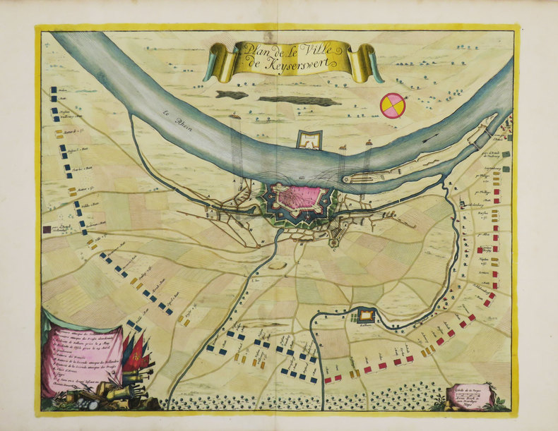
BEECK (Anna).
[KAISERSWERTH] Plan de la ville de Keyserswert.
La Haye, Anna Beek, [1702]. 383 x 470 mm.
Référence libraire : LBW-3491
|
|
|
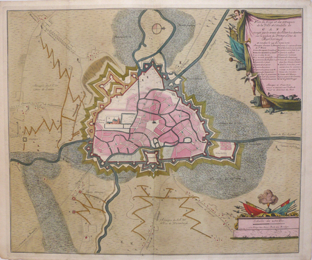
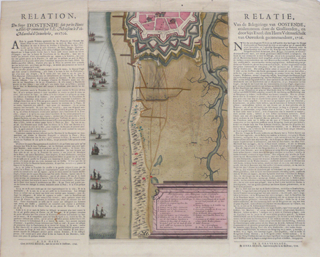
BEECK (Anna);
[OSTENDE] Fortificatie en attaque van Oostende.
La Haye Anna Beeck 1706 En 3 feuilles collées ensemble de 370 x 467 mm.
Référence libraire : LBW0622a
|
|
|
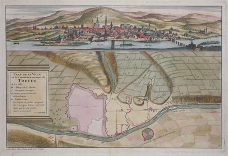
BEECK (Anna);
[TREVES] Plan de la ville et des nouveaux ouvrages de Treves.
La Haye Anna Beek circa 1710 244 x 370 mm.
Référence libraire : LBW0622b
|
|
|
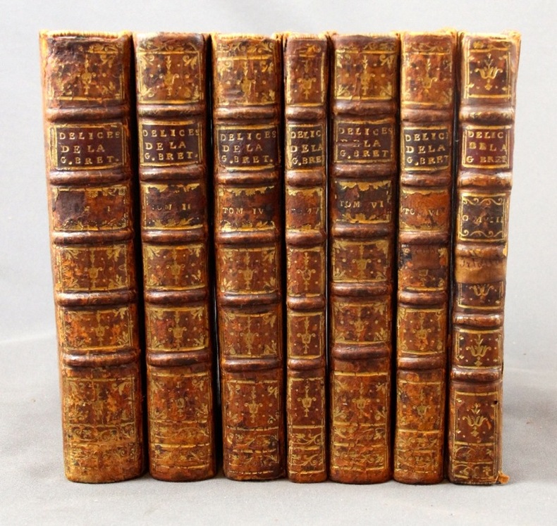
BEEVERELL James:
Les délices de la Grand’ Bretagne, & de l’Irlande; Où sont exactement décrites les Antiquitez, les Provinces, les Villes, les Bourgs, les Montagnes, les Rivières, les Ports de mer, les Bains, les Forteresse, Abbaies,...
A Leide, Chez Pierre Vander, 1727. 7 vol. (sur 8) in-8 de 1506-[2] (Pagination continue : [17 ff.], [278] + [299] + [164] + [128] + [198] + [177] + [131] pp.), plein veau havane moucheté, dos à nerfs ornés de fleurons dorés, étiquettes de titre bordeaux, tranches rouges. Dos et coins frottés, coiffes sup. des vol. 1, 4, 5 et 8 manquantes, coiffes inf. du vol. 8 manquante, accroc à la coiffe sup. vol. 6 et à la coiffe inf. vol. 4, mors 1er plat légèrement fendu aux vol. 1, 2, 4 et 5 (env. 1 cm.), quelques rousseurs sur les cartes et pl.
Référence libraire : 2311
|
|
|
Bee Jay
Scotland's Shangri-La
No marks or inscriptions. A very clean very tight copy with bright unmarked pale green boards, slight bumping to lower page corners and no bumping to board corners. Dust jacket not price clipped or torn with slight marking and very minor creasing to edges. 359pp. The far north-west of Scotland in Wester Ross and Sutherland.

|
|
|
Beebe Lucius AUTOGRAPHED/Clegg Charles AUTOGRAPHED/Hammack ES. decorations/Shaw Fredric maps/lettering E. S.
Virginia & Truckee: A Story of Virginia City and Comstock Times
Oakland: Grahame H. Hardy 1949. 3rd edition. VG/VG dust jacket 1/4 inch tears to edges of dust jacket. SIGNED BY BOTH AUTHORS special Bucket of Blood edition 72 p. photos illus maps illus endpapers 8vo; Grahame H. Hardy hardcover
Référence libraire : 67522

|
|
|
Behrman S. N. & line drawings/photos/maps
Portrait of Max
Random House. Very Good in Good dust jacket. 1960. Hardcover. used but still very attractive. Dustjacket is good though rippled at the top from moisture; 9 X 6.60 X 1.60 inches . Random House hardcover
Référence libraire : 112237

|
|
|
BELLIN (Jacques-Nicolas).
[AFRIQUE DU SUD] Carte de la baye de Saldana ou Saldane.
[circa 1760]. 200 x 278 mm.
Référence libraire : LBW024b7
|
|
|
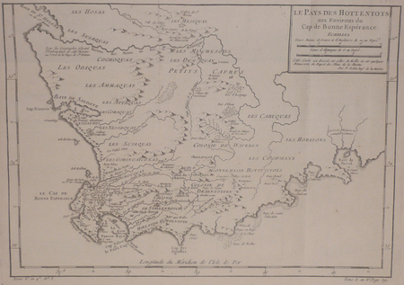
BELLIN (Jacques-Nicolas).
[AFRIQUE DU SUD] Le pays des Hottentots aux environs du Cap de Bonne Espérance.
[circa 1760]. 245 x 348 mm.
Référence libraire : LBW024b8
|
|
|
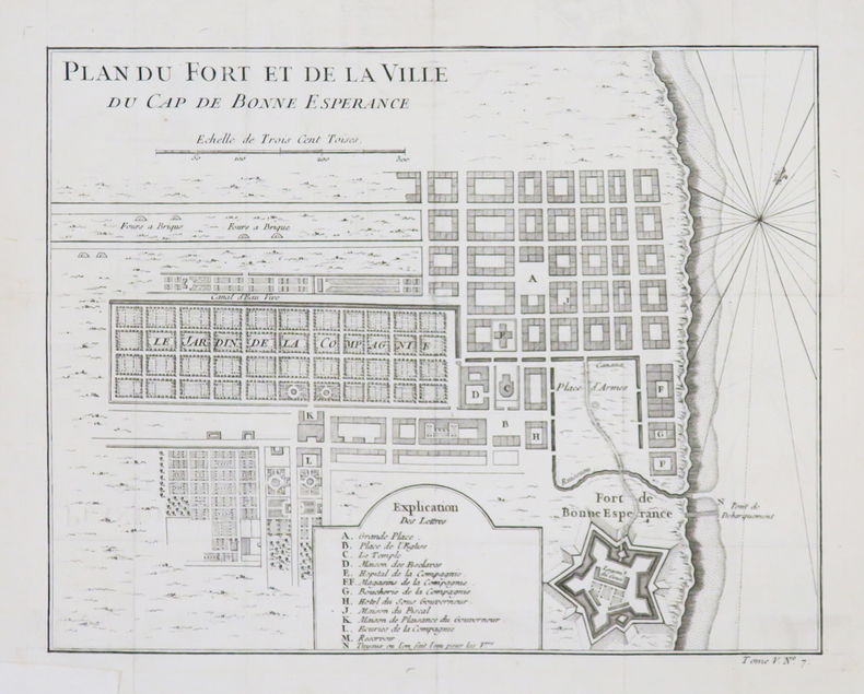
BELLIN (Jacques-Nicolas).
[AFRIQUE du SUD/LE CAP] Plan du fort et de la ville du Cap de Bonne Espérance.
[circa 1760]. 209 x 265 mm.
Référence libraire : LBW-4532
|
|
|
BELLIN (Jacques-Nicolas).
[ALGERIE] Plan de la ville forts et port d'Alger.
[1764]. 211 x 169 mm.
Référence libraire : LBW01b58
|
|
|
BELMAS (Jacques-Vital) & TARDIEU (Ambroise).
[ALMEIDA] Plan du siège d'Almeida par l'armée française de Portugal en 1810.
[1836]. 596 x 878 mm.
Référence libraire : LBW-5980

|
|
|
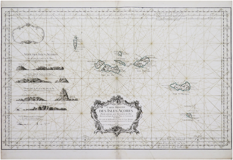
BELLIN (Jacques-Nicolas).
[AÇORES] Carte réduite des Isles Açores.
Paris, M. Bellin, 1755. 557 x 897 mm.
Référence libraire : LBW-8147
|
|
|
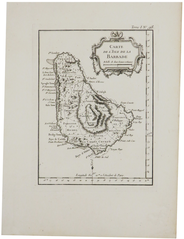
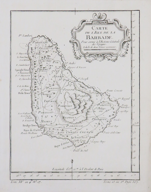
BELLIN (Jacques-Nicolas).
[BARBADE] Carte de l'isle de la Barbade.
1764. 200 x 147 mm.
Référence libraire : LBW-2370
|
|
|
BELLIN (Jacques-Nicolas).
[BARBADE] Carte de l'isle de la Barbade.
[circa 1770]. 199 x 149 mm.
Référence libraire : LBW-4879
|
|
|
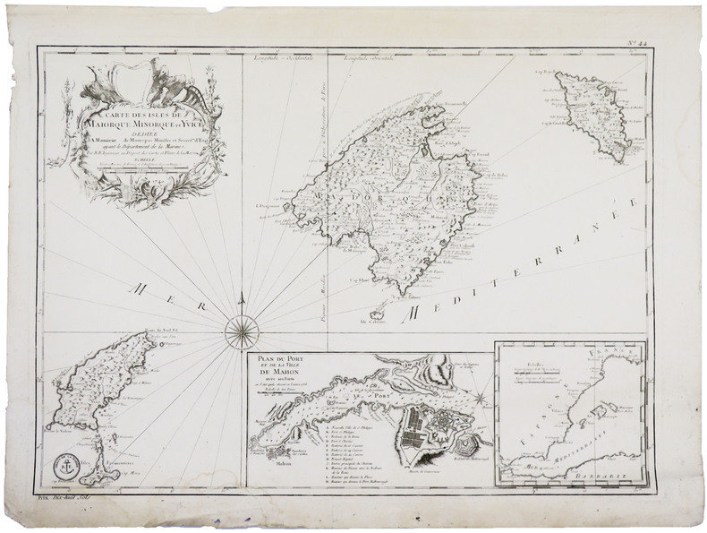
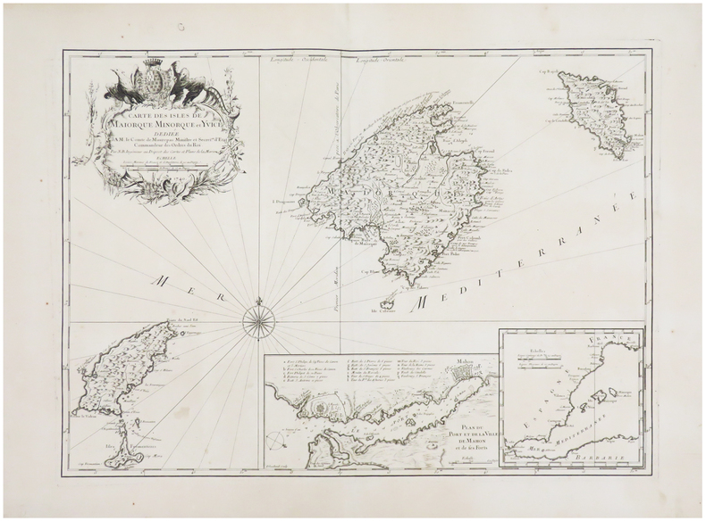
BELLIN (Jacques-Nicolas).
[BALÉARES] Carte des isles de Maiorque Minorque et Yvice.
[Paris], 1740-1756. 410 x 576 mm.
Référence libraire : LBW-5915
|
|
|
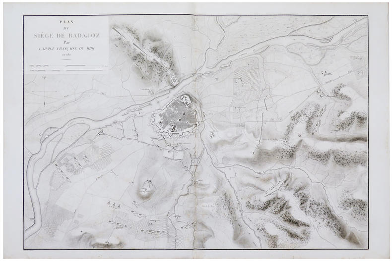
BELMAS (Jacques-Vital) & TARDIEU (Ambroise).
[BADAJOZ] Plan du siège de Badajoz par l'armée française du Midi en 1811.
[1836]. 611 x 898 mm.
Référence libraire : LBW-5982
|
|
|
BELLIN (Jacques-Nicolas).
[BALÉARES/MINORQUE] Carte des isles de Maiorque Minorque et Yvice.
Paris, 1740. 408 x 563 mm.
Référence libraire : LBW-6526
|
|
|
BELLIN (Jacques-Nicolas).
[BALÉARES] L'isle de Maiorque - L'isle de Minorque - Carte de l'isle d'Yvice et des Fromentieres.
[Paris, 1764]. 238 x 346 mm.
Référence libraire : LBW-7210

|
|
 Recevoir par e-mail
 Télécharger en PDF
 Flux RSS


