|
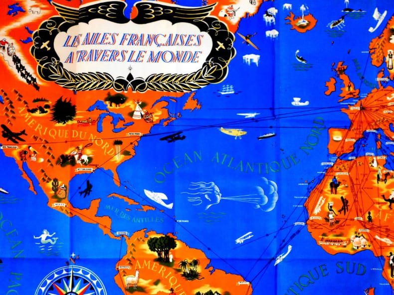
Bié (André)
Soixante ans de performances Française. Illustration de Claude Staudenmayer.
La Nouvelle édition, 1945. In quarto au format 18.5 x 24 cm, couverture unie titré en rouge et noirXXII planches au trait, 127 pages. Complet de la carte du monde dépliante d'1,50 mètre par 65 cm, laquelle est remarquablement conservée. Dos réparé, petits manques, première garde contrecollée sur le second plat, tenue bien carrée. Rare.
書籍販売業者の参照番号
: 20484
|
|
|
Blackie & Son.
A SURVEY OF THE BRITISH EMPIRE. Historical, Geographical and Commercial.
352p. + color maps. Numerous text maps, photographs and drawings. Decorated title page stamped with a Glasgow bookseller's label. Lacks first and last endpapers. Small 8vo. (7") Original full red cloth binding, decorated and lettered in black. Binding soiled. Hardbound. ENGLAND BOX 2
|
|
|
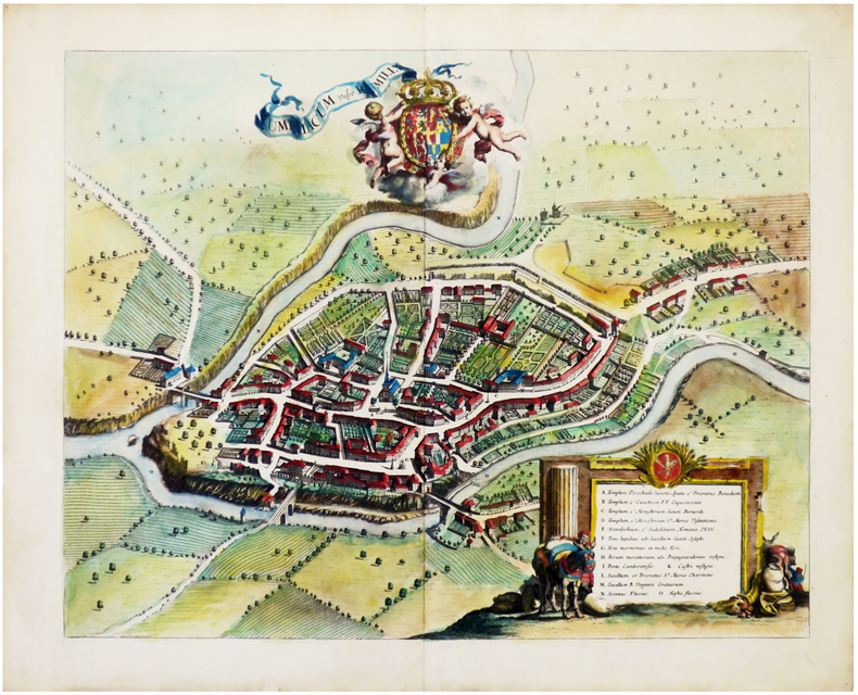
BLAEU (Guillaume)
Bressia vulgo BRESSE.
1645 cadre en bois moderne, sous vitre. carte encadrée, dimmensions 44 x 55 cm. Amsterdam Blaeuw (ca. 1645)
書籍販売業者の参照番号
: 16408
|
|
|
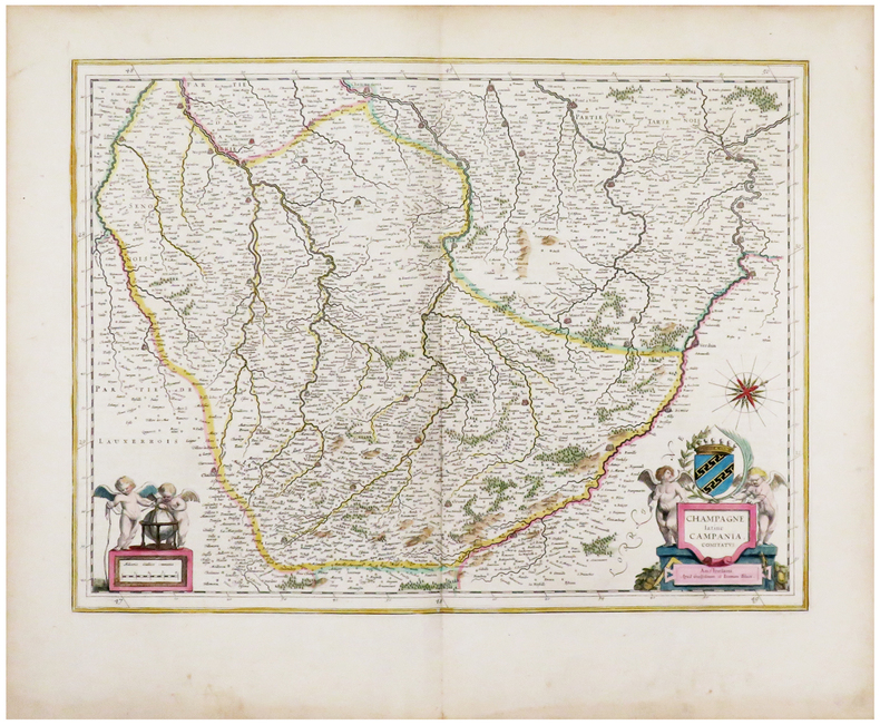
BLAEU (Johannes) & BLAEU (Willem).
[CHAMPAGNE] Champagne latine Campania, comitatus.
Amsterdam, [1643-1650]. 379 x 497 mm.
書籍販売業者の参照番号
: LBW-6197
|
|
|
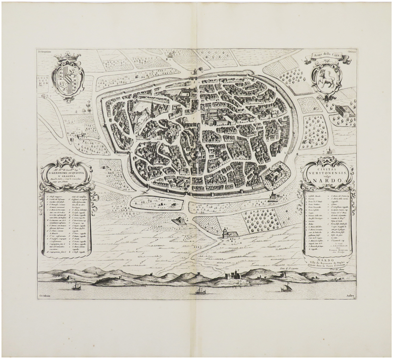
BLAEU (Johannes) & MORTIER (Pierre).
[NARDO] Civitas Neritonensis, vulgo Nardo - Nardo ville du Royaume de Naples située dans la terre d'Otranto.
[Amsterdam, Pierre Mortier, 1704-1705]. 413 x 523 mm.
書籍販売業者の参照番号
: LBW03593
|
|
|
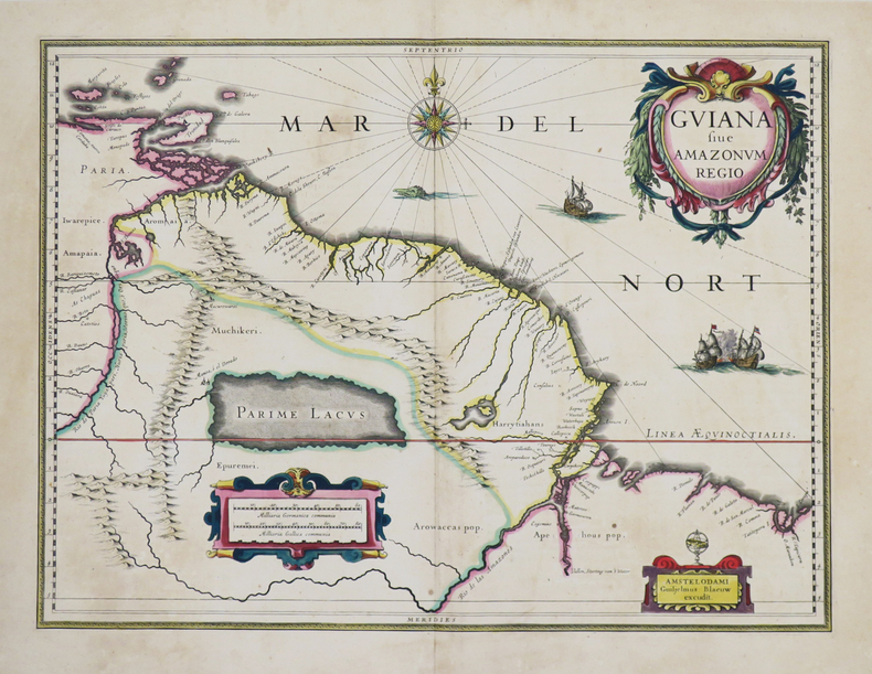
BLAEU (Johannes).
[GUYANE] Guiana sive Amazonum regio.
[Amsterdam, 1635-1638]. 373 x 494 mm.
書籍販売業者の参照番号
: LBW-4801
|
|
|
BLAEU (Johannes).
[LUXEMBOURG] Luceburgum.
[1649-1652]. 219 x 303 mm.
書籍販売業者の参照番号
: LBW-1063

|
|
|
BLAEU (Johannes).
[SAVOIE/RUMILLY] Rumiliacum vulgo Rumilly.
[Amsterdam, 1682]. 457 x 575 mm.
書籍販売業者の参照番号
: LBW-6784
|
|
|
BLAEU (Johannes).
Gouvernement général du Lyonnois.
Amsterdam, [circa 1660]. 410 x 572 mm.
書籍販売業者の参照番号
: LBW-422
|
|
|
BLAEU (Johannes);
[BRESIL] Nova et accurata Brasiliae totius tabula.
Amsterdam Petrus Schenk circa 1680 497 x 588 mm.
書籍販売業者の参照番号
: LBW04170

|
|
|
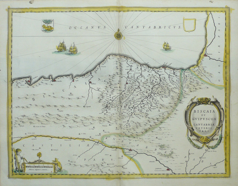
BLAEU (Johannes);
[PAYS BASQUE] Biscaia et Guipuscoa Cantabriae veteris pars.
Amsterdam vers 1640 380 x 497 mm.
書籍販売業者の参照番号
: LBW02501
|
|
|
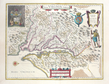
BLAEU (Johannes);
[VIRGINIE] Nova Virginiae tabula.
Amsterdam 1643-1650 376 x 481 mm.
書籍販売業者の参照番号
: LBW03574
|
|
|
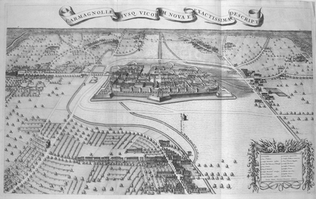
BLAEU (Johannes);MORTIER (Pierre);
[CARMAGNOLA] Carmagnoliae eiusq. vicorum nova et exactissima descriptio.
Amsterdam Pierre Mortier 1704-1705 496 x 817 mm.
書籍販売業者の参照番号
: LBW03597
|
|
|
BLAEU (Johannes);MORTIER (Pierre);
[LIVOURNE] La ville de Livorne.
Amsterdam Pierre Mortier 1704-1705 446 x 533 mm.
書籍販売業者の参照番号
: LBW03594
|
|
|
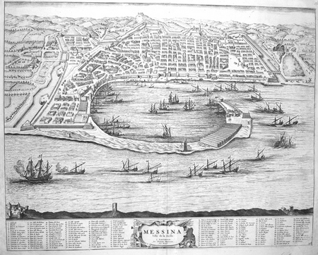
BLAEU (Johannes);MORTIER (Pierre);
[MESSINE] Messina ville de la Sicile.
Amsterdam Pierre Mortier 1704 414 x 522 mm.
書籍販売業者の参照番号
: LBW00282
|
|
|
BLAEU (Johannes);MORTIER (Pierre);
[MILAZZO] Melazzo ou Milazzo, ville de la vallée de Demona, en Sicile.
Amsterdam Pierre Mortier 1704-1705 410 x 541 mm.
書籍販売業者の参照番号
: LBW03599
|
|
|
BLAEU (Johannes);MORTIER (Pierre);
[NOCERRA/CASTELNOVO] Nocerra ville de l'Etat de l'Eglise, dans le duché de Spoleto - Castel Novo. Entre Lorete & Rome.
Amsterdam Pierre Mortier 1704-1705 408 x 514 mm.
書籍販売業者の参照番号
: LBW0359a
|
|
|
BLAEU (Johannes);MORTIER (Pierre);
[POUZZOLES] Puteolanus ager. Le golfe de Pouzol et une partie du golfe de Naples elle est vers la ville de Pouzol, & les ruines des Baies.
Amsterdam Pierre Mortier 1704 406 x 510 mm.
書籍販売業者の参照番号
: LBW00281

|
|
|
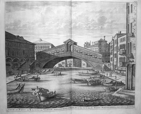
BLAEU (Johannes);MORTIER (Pierre);
[VENISE] Veue du pont de Rialto de Venise.
Amsterdam Pierre Mortier 1704 442 x 534 mm.
書籍販売業者の参照番号
: LBW00271
|
|
|
BLAEU (Johannes);MORTIER (Pierre);
[VOLTERRA] Nova Vulterrae delineatio. Volterre ancienne ville de Toscane, suffragante de Florence, située dans le Pisan.
Amsterdam Pierre Mortier 1704-1705 403 x 558 mm.
書籍販売業者の参照番号
: LBW03598

|
|
|
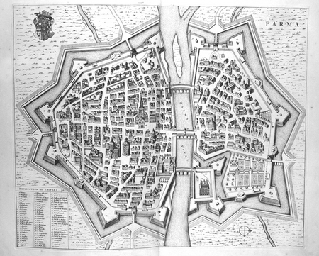
BLAEU (Johannes);MORTIER (Pierre);
Parma.
Amsterdam Pierre Mortier 1704 411 x 498 mm.
書籍販売業者の参照番号
: LBW00272
|
|
|
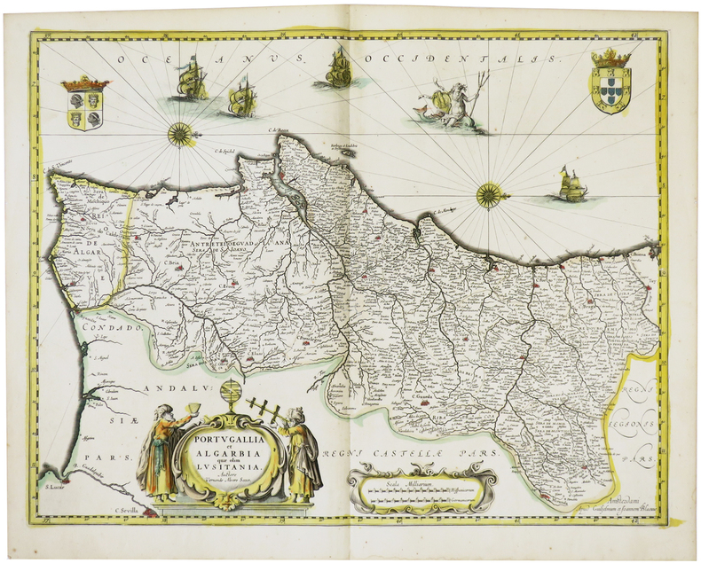
BLAEU (Willem & Johannes).
[PORTUGAL] Portugallia et Algarbia quae olim Lusitania.
Amsterdam, [circa 1640]. 382 x 498 mm.
書籍販売業者の参照番号
: LBW-1469
|
|
|
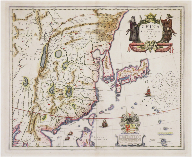
BLAEU (Willem & Johannes).
China veteribus Sinarum regio nunc incolis tame dicta.
[Amsterdam, 1640-1655]. 413 x 502 mm.
書籍販売業者の参照番号
: LBW-8068
|
|
|
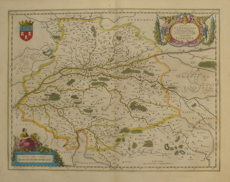
BLAEU (Willem & Johannes);
Ducatus Turonensis - Touraine.
Amsterdam 1661 380 x 497 mm.
書籍販売業者の参照番号
: LBW-862
|
|
|
BLAEU (Willem & Johannes);
Picardia regio Belgica.
Amsterdam 1661 379 x 532 mm.
書籍販売業者の参照番号
: LBW-859

|
|
|
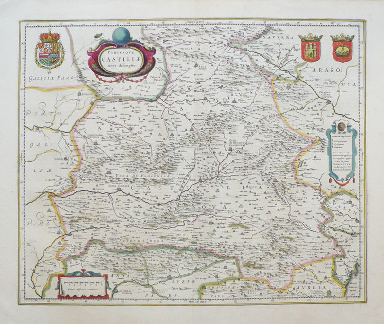
BLAEU (Willem & Johannes);
Utriusque Castiliae nova descriptio.
Amsterdam 1638-1640 411 x 501 mm.
書籍販売業者の参照番号
: LBW-949
|
|
|
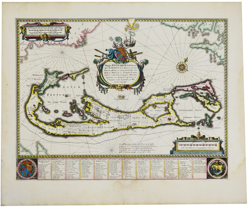
BLAEU (Willem).
[BERMUDES] Mappa aestivarum insularum, alias Barmudas.
[Amsterdam, 1643-1650]. 403 x 532 mm.
書籍販売業者の参照番号
: LBW-2736
|
|
|
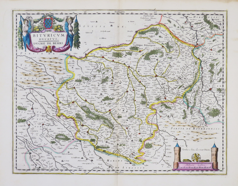
BLAEU (Willem).
[BERRY] Bituricum ducatus - Duché de Berri.
Amsterdam, [1643-1650]. 380 x 498 mm.
書籍販売業者の参照番号
: LBW-861
|
|
|
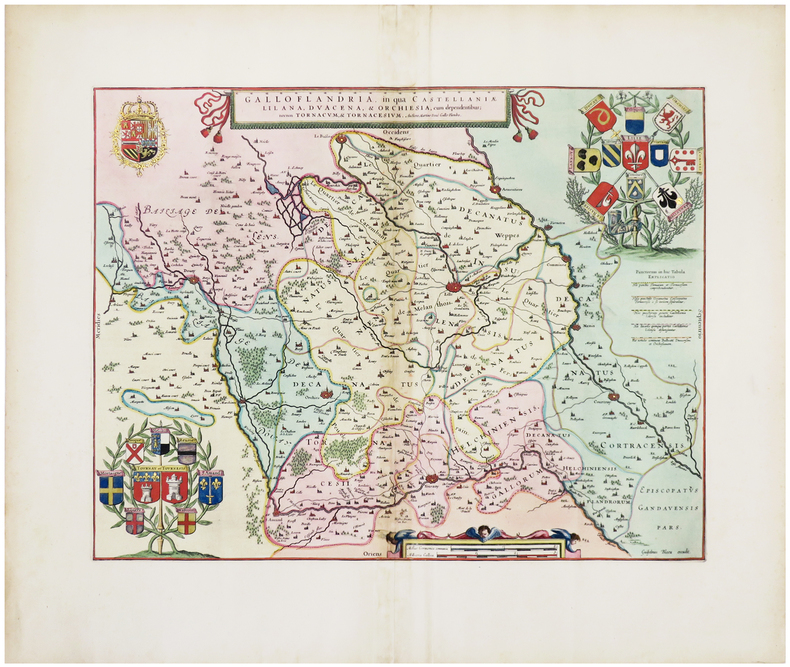
BLAEU (Willem).
[FLANDRE] Galloflandria, in qua Castellaniæ Lilana, Duacena, & Orchiesia, cum dependentibus ; nec non Tornacum, & Tornacesium.
[Amsterdam, 1662]. 374 x 486 mm.
書籍販売業者の参照番号
: LBW-6308
|
|
|
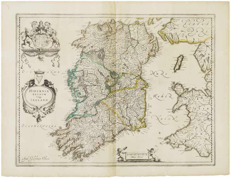
BLAEU (Willem).
[IRLANDE] Hibernia regnum vulgo Ireland.
[Amsterdam, vers 1640]. 384 x 497 mm.
書籍販売業者の参照番号
: LBW-1474
|
|
|
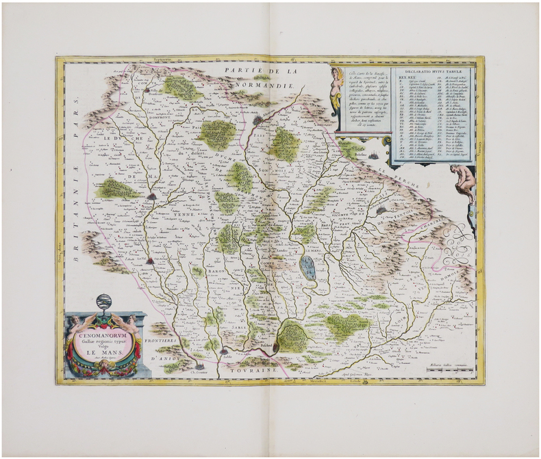
BLAEU (Willem).
[MAINE] Cenomanorum Galliæ regionis typus vulgo Le Mans.
[Amsterdam, 1642-1650]. 382 x 500 mm.
書籍販売業者の参照番号
: LBW-8049
|
|
|
BLAEU (Willem).
[VENEZUELA] Venezuela, cum parte australi Novæ Andalusiæ.
Amsterdam, [1643-1650]. 374 x 486 mm.
書籍販売業者の参照番号
: LBW-6242

|
|
|
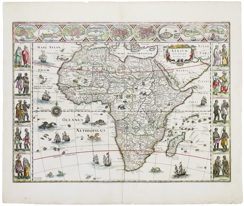
BLAEU (Willem).
Africæ nova descriptio.
[Amsterdam, 1642-1664]. 409 x 557 mm.
書籍販売業者の参照番号
: LBW-5053
|
|
|
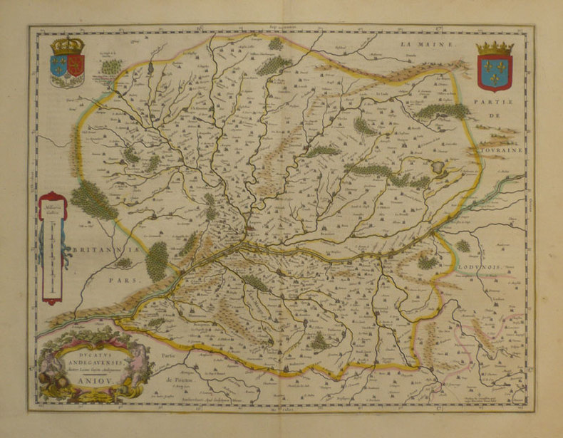
BLAEU (Willem);
Ducatus Andegavensis - Anjou.
Amsterdam 1661 381 x 497 mm.
書籍販売業者の参照番号
: LBW-863
|
|
|
Blaeu, Johan [Joan Blaeuw]
Iutia olim Cimbrica Chersonesus [Jütland, einst Cimbrica Chersonesus]. Kolorierte Kupferstichkarte mit 2 figürlichen Kartuschen.
[Amsterdam, Johannes Blaeu, [ca. 1667]. Darstellung ca. 43,5 x 57,5 cm., Blatt ca. 52 x 61 cm.
書籍販売業者の参照番号
: 79684

|
|
|
Blaeu, Johannes; [Joan Bleau]
Calabria Citra olim Magna Graecia. [Altkolorierter Kupferstich / colored copper engraving].
o.J. Joan Blaeu (Johannes Blaeu), geboren 1596 in Alkmaar, Niederlande; gestorben 1673 in Amsterdam.
書籍販売業者の参照番号
: 53247BB

|
|
|
Blaeu, Willem
Stiria. Steyrmarck. Zeitgenössisch grenzkolorierte Kupferstichkarte.
Amsterdam, W. Blaeu um 1639. Bildausschnitt: 50x37,5 cm, Blattgröße: 49,7 x 59 cm; mittiger, gebräunter Falz, oben rechts dekorative Wappenkartusche, auf Rückseite lateinische Legende mit attraktiver Anfangsinitiale. Attraktives Blatt.
書籍販売業者の参照番号
: KART0160

|
|
|
Blaeu, Willem Janszoon
Circulus Westphalicus sive Germaniae inferioris. [Altkolorierter Original-Kupferstich / original colored copper engraving].
o.J. Willem Janszoon Blaeu, (auch: Guiljelmus Blaeuw, Willem Jansz, Willems Jans Zoon, Guilielmus oder G. Blaeu), geboren 1571 in Alkmaar oder Uitgeest, gestorben 1638 in Amsterdam. Niederländischer Kartograf und Verleger. [2 Warenabbildungen]
書籍販売業者の参照番号
: 12065DB

|
|
|
Blaeu, Willem Janszoon:
"Territorium Norimbergense". Kupferstich mit zwei zeitgenössisch kolorierten dekorativen Kartuschen und rechts unten mit einer Gesamtansicht von Nürnberg aus der Vogelschau sowie mit zeitgenössischenm Grenz- und Landschaftskolorit.
36,5 x 47 cm. Blattgröße: 50 x 61 cm. *Rückseitig ohne Text. Breitrandiges sehr gut erhaltenes Exemplar, lediglich am Unterrand leicht fingerfleckig. Landkarten de
|
|
|
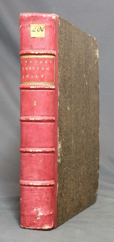
BLAINVILLE:
Travels Through Holland, Germany, Switzerland, and Other Parts of Europe, But Especially Italy. Vol. I.
London, printed by W. Strahan for John Noon and R. Dodsley, 1743. In-4 de [6]-XII-[16-index]; de 49 à 564-XII (the contents)-[2] pages, demi-basane vieux rose, coins de veau brun, dos à 5 nerfs avec titre et encadrement dorés, tranches marbrées.
書籍販売業者の参照番号
: 12672
|
|
|
Blair, John L. (editor)
The Lake District
No marks or inscriptions. A very clean very tight copy with bright unmarked boards and no bumping to corners. Dust jacket not price clipped with dusty rear, piece missing around spine foot and a few small tears. 124pp. A guide to England's Lake District. Undated ca 1958.

|
|
|
Blake, Don
Blakeburn - From Dust to Dust: The Rise and Fall of a Coal Mining Town
(iv), 164 pages. Bibliography. Tables. Many black and white reproductions of archival black and white photos. Two fold-out maps. Author discovered the remains of Blakeburn while on vacation and, after finding a dearth of relevant history, decided to write a history of the town, located northwest of Princeton, B.C. First fold-out map shows the major buildings in Blakeburn and the underground workings of her three major mines in 1935. Second map shows No. 4 mine after the August 13, 1930 explosion. (Hale & Barman 84) Book

|
|
|
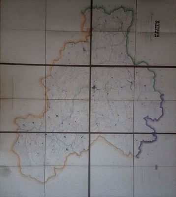
BLANC - DUVIOL
Carte routière et vicinale de l'arrondissement de Lodève dressée sous l'administration de Monsieur Balland, Préfet de l'Hérault, de Monsieur Alazard sous Préfet par Blanc, Agent Voyer ordinaire et Duviol, Agent Voyer conducteur, dessinateur
Vers 1850. Superbe carte monumentale entoilée manuscrite, encre et aquarelle, de 6 feuilles mesurant en totalité 1, 20 mêtre sur 1,32 mètre. Chaque feuille de 60 x 44 cm. L'ensemble replié dans un étui cartonné, titre sur une vignette contrecollée. Echelle de 23 dix millième de mètres pour 100 mètres. On notera une grande précision dans le dessin quant aux chemins vicinaux, à l'habitat, aux noms des Hameaux, Mas, Lieux dits, Riviéres ou Ruisseaux, Moulins ou Usines, Auberges, Relais de Poste, Eglises, Ponts, Ruines, Bergeries avec noms des propriétaires etc. Etui un peu frotté, vignette contrecollée tachée. Très bel état de la carte.

|
|
|
BLANC - DUVIOL
Carte routière et vicinale de l'arrondissement de Lodève dressée sous l'administration de Monsieur Balland, Préfet de l'Hérault, de Monsieur Alazard sous Préfet par Blanc, Agent Voyer ordinaire et Duviol, Agent Voyer conducteur, dessinateur
Sans lieu Vers 1850. Superbe carte monumentale entoilée manuscrite, encre et aquarelle, de 6 feuilles mesurant en totalité 1, 20 mêtre sur 1,32 mètre. Chaque feuille de 60 x 44 cm. L'ensemble replié dans un étui cartonné, titre sur une vignette contrecollée. Echelle de 23 dix millième de mètres pour 100 mètres. On notera une grande précision dans le dessin quant aux chemins vicinaux, à l'habitat, aux noms des Hameaux, Mas, Lieux dits, Riviéres ou Ruisseaux, Moulins ou Usines, Auberges, Relais de Poste, Eglises, Ponts, Ruines, Bergeries avec noms des propriétaires etc. Etui un peu frotté, vignette contrecollée tachée. Très bel état de la carte.
書籍販売業者の参照番号
: 131674
|
|
|
Blandford, Percy W.
Maps & Compasses : A User's Handbook
243 pages including index and glossary. Normal library markings. Abover average wear to boards with portion of front board peeled off at lower left corner. Corner of title page clipped off. Learn to read all there is to be found on a map. Learn to use the map with a compass. Learn to make simple maps and plans. These are worthwhile accomplishments. They are what this book is all about. Complete with many black and white diagrams and occasional photographs. A very practical book. Book
|
|
|
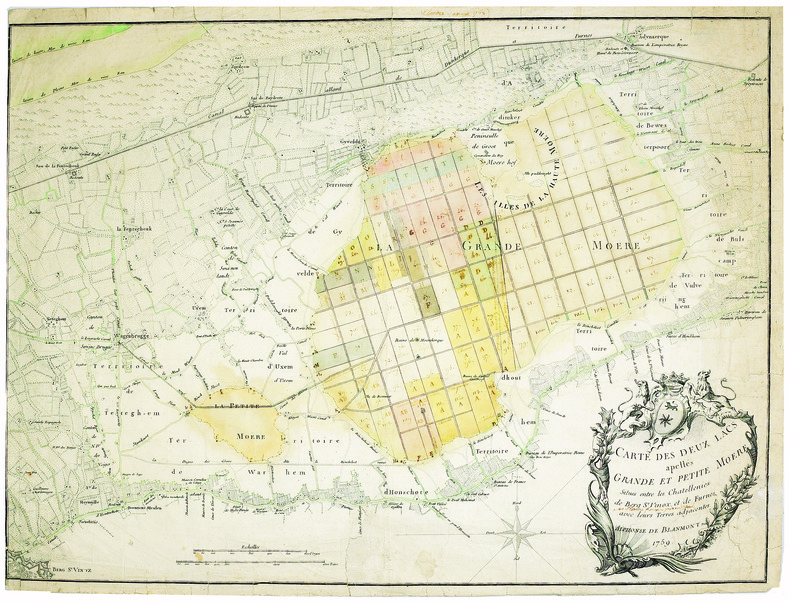
BLANMONT (Alphonse). MANUSCRIT.
Carte des deux lacs apellés Grande et Petite Moëre, situés entre les chatellenies de Berg S.t Vinox, et de Furnes avec leurs terres adjacentes.
1759. 480 x 635 mm.
書籍販売業者の参照番号
: LBW-4098
|
|
|
Blanpied Pamela Wharton Illustrated by Photos Maps
Dragons
NY: Warner Books. VG. 1980. 1st Edition. Hardcover. Cloth & Boards. Very Good/Very Good. First Edition. 8vo - over 7�" - 9 �" tall. First edition bound in brown cloth & yellow boards. A little shelf wear small ink spot on the upper spine. Dj faded shelf worn p rice clipped. . Warner Books hardcover
書籍販売業者の参照番号
: 9855
|
|
|
BLASI Alfredo
Roma (Veduta dal Gianicolo)
Veduta panoramica della città dal Gianicolo. Pubblicazione fatta a cura del Consiglio Centrale per l'Italia dalla Pontificia Opera della Propagazione della Fede.In basso una legenda di 46 richiami sui luoghi notabili della città.Xilografia a colori, di Alfredo Blasi, la cui firma è in basso a destra.Rara. Veduta panoramica della città dal Gianicolo. Pubblicazione fatta a cura del Consiglio Centrale per l'Italia dalla Pontificia Opera della Propagazione della Fede.In basso una legenda di 46 richiami sui luoghi notabili della città.Xilografia a colori, di Alfredo Blasi, la cui firma è in basso a destra.Rara.

|
|
|
BLASSELLE Ren? - BONNET Marc - SERRYN Pierre
Les atlas.Tome second : -1 Atlas g?ographique -2 Atlas historique.
Reli?. 168 + 79 pages. 21 x 30 cm.
|
|
|
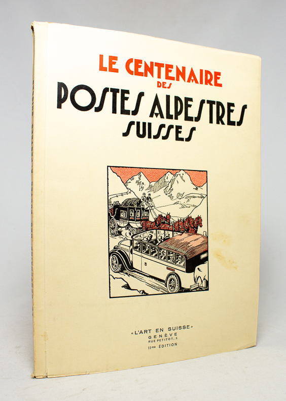
BLOESCH H.; BUDRY Paul; CHAPONNIERE Paul; GRELLET Pierre; HENRIOUD Marc:
Le centenaire des postes alpestres suisses.
Genève, L'Art en Suisse, 1932. In-4 broché de 80 pages, couverture à rabats illustrée en deux tons.
書籍販売業者の参照番号
: 17496
|
|
 検索結果のメールを受信する
 PDFファイルの検索結果をダウンロード
 RSSフィード


