|
HÜSEYIN HÜSNÜ EMIR [ERKILET], (Turkish map maker, author and soldier), (1883-1958).
[Original photograph of Hüseyin Hüsnü Emir Erkilet].
Very Good Turkish Original b/w photograph. 9x14 cm. It shows Erkilet and many women and men with a child around him. Probably it's taken during a travel. Erkilet was an officer of the Ottoman Army and the general of the Turkish Army. In the fall 1941 he, along with General Ali Fuad Erden, visited the occupied territories in Ukraine (including Crimea) on invitation of Gerd von Rundstedt. From there he and other Turkish officers flew to Rastenburg to meet Hitler in person. In 1943 he published his essays on that trip under title "What I Saw on the Eastern Front". Being a staunch Turanist, he was briefly detained for Panturkic activities in 1948 together with some other prominent Turanists.
|
|
|
HÜSEYIN HÜSNÜ EMIR [ERKILET], (Turkish map maker, author and soldier), (1883-1958).
[Original photograph of Hüseyin Hüsnü Emir Erkilet].
Very Good Turkish Original b/w photograph. 9x14 cm. It shows Erkilet and two other men and a woman sitting around a table. Erkilet was an officer of the Ottoman Army and the general of the Turkish Army. In the fall 1941 he, along with General Ali Fuad Erden, visited the occupied territories in Ukraine (including Crimea) on invitation of Gerd von Rundstedt. From there he and other Turkish officers flew to Rastenburg to meet Hitler in person. In 1943 he published his essays on that trip under title "What I Saw on the Eastern Front". Being a staunch Turanist, he was briefly detained for Panturkic activities in 1948 together with some other prominent Turanists.
|
|
|
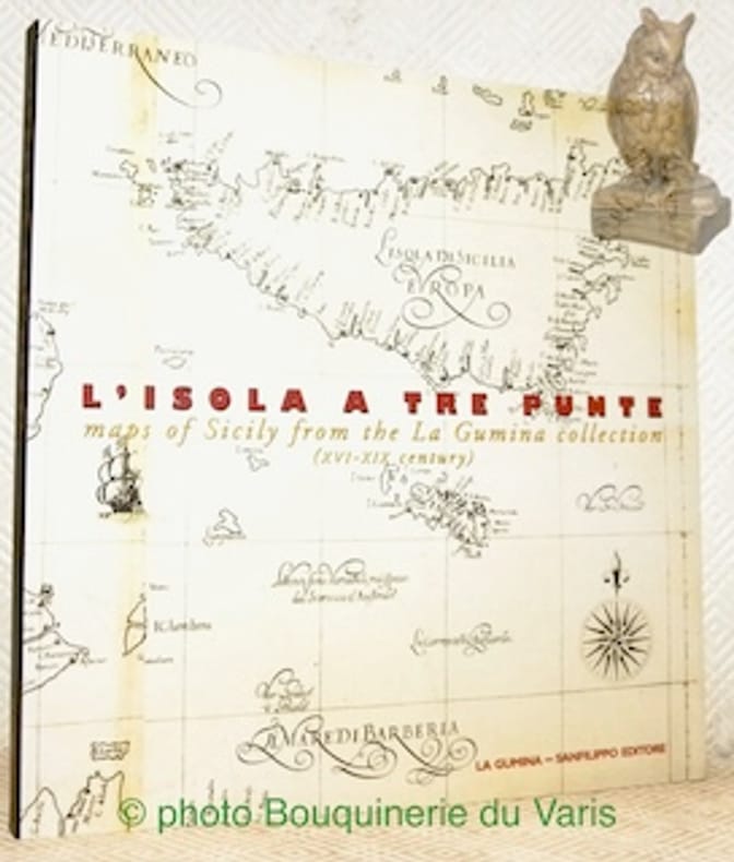
Iachello, Enrico.
L’isola a tre punte maps of Sicily from the La Gumina collection (XVIe-XIX Century).
Catania, La Gumina - Sanfilipo Editore 1999, 230x220mm, 191pages, paperback. Book in good condition.
Référence libraire : 110522
|
|
|
IAN DOBRACZYNSKI
Celui qui vint la nuit, lettres d'un pharisien.
Selection Mame, 1956, 293 pages, in 8 broché, état d'usage, papier jauni, usures et pliures, dos fatigué, jaquette état moyen, quelques déchirures.
Référence libraire : 8004
|
|
|
ILHAN PINAR
Izmir city plans and maps from the Ottoman Era.= Osmanli dönemi Izmir planlari ve haritalari.
New English Original decorative cloth bdg. Folio. (33 x 33 cm). In English and Turkish.155 p., color and b/w ills., maps (some folded). Some of plans - maps and their makers from the contents of book: "The earliest city planning sketches displaying the then status of the city are the plans drawn by Livio Amedeo Missir located at the Santa Maria Church.", The well-known geographer Jean Denis barbie de Bocage's plan, In 1830s, British Navy Officer's plans, Luigi Storari's plan, Lamec Saad's plan, Charles Goad's plans, Karl Baedeker's plans, and very important maps of Izmir (Smyrna - Smyrne) city. 500 copies were printed.
|
|
|
ILLE ET VILAINE
Carte grav?e (en noir) du d?partement. Extrait du Petit Atlas National. Fin XIXe.
1 feuille 24x30 cm. Rousseurs.
|
|
|
ILLE ET VILAINE
Carte routi?re d?partementale couleurs au 1/320 000?.
Une feuille 58x39 cm.
|
|
|
Illustrated in Color Maps
1978 Los Angeles Times Orange County Los Angeles Glove Compartment Street Atlas Complete Street Index California With Color Maps Places of Interest Cemeteries Colleges Beaches Amusement Parks Legitimate Theatre Golf Courses Museums Hotels ET
CReated & Publ. Gousha/Chek-Chart San Jose Mitock North Hollywood 1978. PBO Spiral Bound Softcover 1978 1st Edition Nice Condition You turn over Book to Back for different 2 Counties NF/NF- SOFTCOVER COVER light ruB wear Creases & Scuff Hotels ETC Orange County & Los Angeles Street Index. First Edition. Soft Cover. CReated & Publ. Gousha/Chek-Chart, San Jose Mitock North Hollywood paperback
Référence libraire : 23102
|
|
|
Illustrated with photographs maps in colour and a time chart of Bible history
Atlas of the Bible Lands
C.S. Hammond & Co distributed in the UK by Oldbourne Press. Used - Good. Shows some signs of wear and may have some markings on the inside. C.S. Hammond & Co, distributed in the UK by Oldbourne Press unknown
Référence libraire : GRP92104735
|
|
|
Illustrated National Geographic Maps Trails
Big Bend National Park National Geographic Trails Illustrated Map 225
National Geographic Maps. MAP. 1566952891 Brand New! Not Overstocks or Low Quality Book Club Editions! Direct From the Publisher! We're not a giant faceless warehouse organization! We're a small town bookstore that loves books and loves it's customers! Buy from us and you get great service as well as a great price! Your business is valued and your satisfaction is guaranteed!VCF . New. National Geographic Maps unknown
Référence libraire : OTF-9781566952897 ISBN : 1566952891 9781566952897

|
|
|
Illustrated National Geographic Maps Trails
Canyons of the Escalante Grand Staircase-Escalante National Monument National Geographic Trails Illustrated Map 710
National Geographic Maps. MAP. 1566953243 Brand NewVCF . New. National Geographic Maps unknown
Référence libraire : DTH-S-9781566953245 ISBN : 1566953243 9781566953245

|
|
|
Illustrated National Geographic Maps Trails
Cape Cod National Geographic Trails Illustrated Map
National Geographic Maps. MAP. 1566953553 Brand NewVCF . New. National Geographic Maps unknown
Référence libraire : DTH-S-9781566953559 ISBN : 1566953553 9781566953559

|
|
|
Illustrated by With Maps and Plans
Cook's Traveller's Handbook Switzerland Including French Savoy and Italian Lakes
London: London: Simpkin Marshall Hamilton Kent & Co. Thos. Cook & Son 1925 1925 Cloth. Very Good. First Edition. Travel Geography. Owner's Name. 16mo - over 5�" - 6�" tall. Red/gilt color foldout map 460 pgs index many ads rear tight copy. Illus. by With Maps and Plans. 16mo - over 5�" - 6�" tall. Owner's Name. First Edition. Cloth. Very Good. London: Simpkin, Marshall, Hamilton, Kent & Co. Thos. Cook & Son, 1925 hardcover
Référence libraire : 00279650
|
|
|
Illustrated National Geographic Maps Trails
Death Valley National Park National Geographic Trails Illustrated Map
National Geographic Maps. MAP. 1566953219 Brand NewVCF . New. National Geographic Maps unknown
Référence libraire : DTH-S-9781566953214 ISBN : 1566953219 9781566953214

|
|
|
Illustrated National Geographic Maps Trails
Death Valley National Park National Geographic Trails Illustrated Map
National Geographic Maps. MAP. 1566953219 Brand New! Not Overstocks or Low Quality Book Club Editions! Direct From the Publisher! We're not a giant faceless warehouse organization! We're a small town bookstore that loves books and loves it's customers! Buy from us and you get great service as well as a great price! Your business is valued and your satisfaction is guaranteed!VCF . New. National Geographic Maps unknown
Référence libraire : OTF-S-9781566953214 ISBN : 1566953219 9781566953214
|
|
|
Illustrated by Photographs and Maps Nancy WilsonRoss
Farthest Reach: Oregon and Washington
Alfred A. Knopf 1946 January 1946. Hardcover. Good/No Jacket. Alfred A. Knopf, 1946 hardcover
Référence libraire : 168243
|
|
|
Illustrated National Geographic Maps Trails
Flagstaff Sedona Coconino and Kaibab National Forests National Geographic Trails Illustrated Map 856
National Geographic Maps. MAP. 1566955157 Brand NewVCF . New. National Geographic Maps unknown
Référence libraire : DTH-S-9781566955157 ISBN : 1566955157 9781566955157

|
|
|
Illustrated by W/photos & Maps Dorothy and Joseph Samachson
GOOD DIGGING THE STORY OF ARCHAEOLOGY
New York: Rand McNally & Company 1960. Hardcover. Acceptable. Disclaimer:A readable copy. All pages are intact and the cover is intact. Pages can include considerable notes-in pen or highlighter-but the notes cannot obscure the text. An ex-library book and may have standard library stamps and/or stickers. At ThriftBooks our motto is: Read More Spend Less.Dust jacket quality is not guaranteed. New York: Rand McNally & Company hardcover
Référence libraire : GB000LZ1MKQI5N10

|
|
|
Illustrated by W/photos & Maps Dorothy and Joseph Samachson
GOOD DIGGING THE STORY OF ARCHAEOLOGY
Hardcover. Very Good. VG unread book/VG- jacket. 2nd ptg. 1961. hardcover
Référence libraire : HX-8WM4-NEMY
|
|
|
Illustrated by Ils. maps/photographs
HANDBOOK TO HOLLAND.
London: Ward Lock and Co. no date c1920's 7th ed. rev. Small/red limp covers. Nice copy. London: Ward, Lock and Co. no date c1920's unknown
Référence libraire : 002485
|
|
|
Illustrated National Geographic Maps Trails
Hawaii Volcanoes National Park National Geographic Trails Illustrated Map
National Geographic Maps. MAP. 1566953294 Brand NewVCF . New. 2010. National Geographic Maps unknown
Référence libraire : DTH-S-9781566953290 ISBN : 1566953294 9781566953290

|
|
|
Illustrated National Geographic Maps Trails
Jasper National Park Map Pack Bundle National Geographic Trails Illustrated Map
National Geographic Maps. MAP. 1566957397 Brand New! No Remainder Marks or Worn Dirty Overstocks!VCF . New. National Geographic Maps unknown
Référence libraire : OTF-S-9781566957397 ISBN : 1566957397 9781566957397
|
|
|
Illustrated National Geographic Maps Trails
John Muir Trail Topographic Map Guide National Geographic Topographic Map Guide National Geographic Topographic Map Guide 1001
National Geographic Maps. MAP. 1566956897 Brand NewVCF . New. National Geographic Maps unknown
Référence libraire : DTH-S-9781566956895 ISBN : 1566956897 9781566956895
|
|
|
Illustrated by Maps
Land for New Hampshire . Final Report of the New Hampshire Land Conservtion Investment Program and the Trust for New Hampshire Lands.
Nh: The Conservation Authority 1993 1993 Spiral Bound. NF/NA. First. 4to - over 9�" - 12" tall. VERY SCARCE: Many Many Maps with town & Parcel descriptions. App. 250 pages. Nh: The Conservation Authority, 1993 unknown
Référence libraire : 011248
|
|
|
Illustrated National Geographic Maps Trails
Mount Rainier National Park National Geographic Trails Illustrated Map 217
National Geographic Maps. MAP. 1566953456 Brand NewVCF . New. National Geographic Maps unknown
Référence libraire : DTH-S-9781566953450 ISBN : 1566953456 9781566953450

|
|
|
Illustrated National Geographic Maps Trails
Mount Rainier National Park National Geographic Trails Illustrated Map 217
National Geographic Maps. MAP. 1566953456 Brand New! Not Overstocks or Low Quality Book Club Editions! Direct From the Publisher! We're not a giant faceless warehouse organization! We're a small town bookstore that loves books and loves it's customers! Buy from us and you get great service as well as a great price! Your business is valued and your satisfaction is guaranteed!VCF . New. National Geographic Maps unknown
Référence libraire : OTF-9781566953450 ISBN : 1566953456 9781566953450
|
|
|
Illustrated National Geographic Maps Trails
National Geographic Trails Illustrated Map 210 Canyonlands UT
National Geographic Maps. MAP. 156695326X Brand NewVCF . New. National Geographic Maps unknown
Référence libraire : DTH-S-9781566953269 ISBN : 156695326X 9781566953269

|
|
|
Illustrated National Geographic Maps Trails
North Cascades National Park National Geographic Trails Illustrated Map
National Geographic Maps. MAP. 1566953537 Brand NewVCF . New. National Geographic Maps unknown
Référence libraire : DTH-S-9781566953535 ISBN : 1566953537 9781566953535

|
|
|
Illustrated National Geographic Maps Trails
Olympic National Park National Geographic Trails Illustrated Map
National Geographic Maps. MAP. 1566954029 Brand NewVCF . New. National Geographic Maps unknown
Référence libraire : DTH-S-9781566954020 ISBN : 1566954029 9781566954020

|
|
|
Illustrated National Geographic Maps Trails
Shenandoah National Park National Geographic Trails Illustrated Map
National Geographic Maps. MAP. 1566953650 Brand NewVCF . New. National Geographic Maps unknown
Référence libraire : DTH-S-9781566953658 ISBN : 1566953650 9781566953658

|
|
|
Illustrated National Geographic Maps Trails
Yosemite National Park National Geographic Trails Illustrated Map
National Geographic Maps. MAP. 1566952999 Brand NewVCF . New. National Geographic Maps unknown
Référence libraire : DTH-S-9781566952996 ISBN : 1566952999 9781566952996

|
|
|
Illustrated National Geographic Maps Trails
Yosemite National Park National Geographic Trails Illustrated Map
National Geographic Maps. MAP. 1566952999 Brand New! Not Overstocks or Low Quality Book Club Editions! Direct From the Publisher! We're not a giant faceless warehouse organization! We're a small town bookstore that loves books and loves it's customers! Buy from us and you get great service as well as a great price! Your business is valued and your satisfaction is guaranteed!VCF . New. National Geographic Maps unknown
Référence libraire : OTF-9781566952996 ISBN : 1566952999 9781566952996
|
|
|
Illustrated National Geographic Maps Trails
Zion National Park National Geographic Trails Illustrated Map
National Geographic Maps. MAP. 1566952972 Brand New! Not Overstocks or Low Quality Book Club Editions! Direct From the Publisher! We're not a giant faceless warehouse organization! We're a small town bookstore that loves books and loves it's customers! Buy from us and you get great service as well as a great price! Your business is valued and your satisfaction is guaranteed!VCF . New. National Geographic Maps unknown
Référence libraire : OTF-S-9781566952972 ISBN : 1566952972 9781566952972

|
|
|
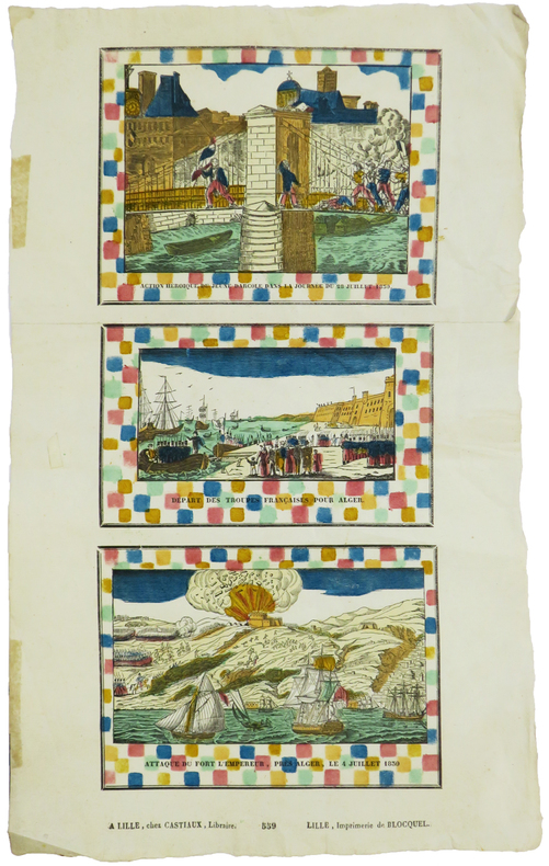
IMAGERIE de LILLE & RÉVOLUTION de JUILLET.
Action héroïque du jeune Darcole dans la journée du 28 juillet 1830 - Départ des troupes françaises pour Alger - Attaque du Fort l'Empereur, près Alger, le 4 juillet 1830.
Lille, Castiaux et Imprimerie de Blocquel, [circa 1830]. En deux feuilles jointes de 400 x 168 mm.
Référence libraire : LBW-5888
|
|
|
Imbert Pierre
Bridge contrat. Le bridge national français, deux-trèfles, blackwood, chelems
Editions du vieux Monaco Brochure 1947 In-12 (11,5 x 17,7 cm), brochure, 95 pages ; rousseurs et quelques marques d'usage sur les plats,par ailleurs assez bon état général. Livraison a domicile (La Poste) ou en Mondial Relay sur simple demande.
Référence libraire : dm504
|
|
|
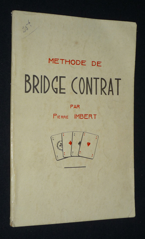
Imbert Pierre
Méthode de bridge contrat
Imbert Pierre Brochure 1940 In-12 (11,5 x 17,8 cm), brochure, 50 pages ; quelques marques d'usage sur les plats, bon état général. Livraison a domicile (La Poste) ou en Mondial Relay sur simple demande.
Référence libraire : qq1392
|
|
|
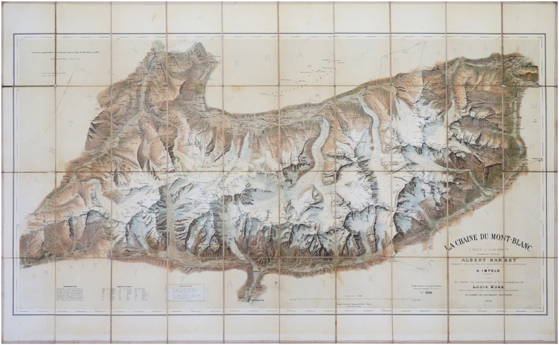
IMFELD (Xaver) & BARBEY (Albert).
[MONT-BLANC] La Chaîne du Mont Blanc. Carte au 1/50 000.
Berne, Kümmerly frères, 1896-1905. En 40 sections montées sur toile et repliées, formant une carte de 0,64 x 1,06 m ; étiquette au dos de la Maison Andriveau-Goujon, H. Barrère, à Paris.
Référence libraire : LBW-8045
|
|
|
Imfeld, X(aver)
Gebirgspanorama vom Belvedère auf dem Zürichberg. Erweiterte Ausgabe des Zürichbergpanorama's oberhalb der Karolinenburg von Alb(ert) Heim.
Zürich, Caesar Schmidt, o.J. (1877). Gef. Federlithographie (Leporello) in Halbleinenumschlag (8°). Bildformat: 16,8 x 167 cm. Blattformat: 19,1 x 168 cm. + Wichtig: Für unsere Kunden in der EU erfolgt der Versand alle 14 Tage verzollt ab Deutschland / Postbank-Konto in Deutschland vorhanden +, 1544A (Einbanddeckel stärker berieben und bestossen).
Référence libraire : 1544AG

|
|
|
IMHOF, Eduard:
Die Ältesten Schweizerkarten. Mit einem Faksimile der ältesten gedruckten Schweizerkarte von 1513 und 3 Abbildungen.
Zürich / Leipzig Orell Füssli Verlag, 1939, in-4to, (Querformat), 15 S. mit 3 Abb. + 1 gef. Kartenbeilage ‘Tabula Nova Heremi Helvetioru’ (ca. 44x57 cm), Original-Pappband mit Titelschild, Orig.-Umschlag.
Référence libraire : 129530aaf
|
|
|
IMHOF, Eduard:
Landkartenkunst, gestern, heute, morgen. Hrsg. v.d. Naturforschenden Gesellschaft in Zürich auf das Jahr 1968. 170. Stück,
Zürich, Kommissionsverlag Leemann AG., 1968, in-8vo, 35 S., 17 s./w. ill + 3 farbtafeln, Original-Broschüre.
Référence libraire : 126359aaf
|
|
|
in Full Color Blank Flyleaf Small Sticker Former Owner. SIGNED By Author Brown Illustrations By Velma Grant Maps By George An
Rock & Miinerals of California & Their Stories
Naturegraph Co San Martin Calif. PBO decorated color Wraps with Color Labels of rocks Light rub Wear & tiny Chips Tears Extremities NF-/NF- 1955 Interior Nice tight Clean light Rub Wear FoX 120 Pages InDex some pgs light Wrinkling . Signed by Author. First Edition. Original Wraps. Naturegraph Co, San Martin, Calif. paperback
Référence libraire : 21242
|
|
|
Inc Langenscheidt Pub
Insight FlexiMap London
Carrollton TX: American Map Corporation 8/30/2005. Map. New. pp1 London Insight FlexiMap features detailed city street and road maps clearly marked with all the sites and services of particular interest to travelers. Text and photographs offer a wealth of valuable tourist information including "10 sights you shouldn't miss" plus information on transportation visas currency important telephone numbers emergency services and more. NEW Map: Fine condition. Gift Quality. Our Maps are shrink-wrapped and carefully packaged to assure your Map will arrive in good condition. SATISFACTION GUARANTEED American Map Corporation unknown
Référence libraire : 162 ISBN : 9812583777 9789812583772
|
|
|
Inc Hedberg Maps
Princeton: Princeton University & Area Streets Professor Pathfinder's Campus Maps
2007-09-10. Good. Ships with Tracking Number! INTERNATIONAL WORLDWIDE Shipping available. May not contain Access Codes or Supplements. May be re-issue. May be ex-library. Shipping & Handling by region. Buy with confidence excellent customer service! unknown
Référence libraire : 1885508913 ISBN : 1885508913 9781885508911

|
|
|
Inc Key Maps
Houston Harris County atlas
good. spiral bound softcover. cover and corner wear. creased covers. paperback
Référence libraire : 050421A280103 ISBN : 1885822103 9781885822109
|
|
|
Inc St. Louis Area Maps
Wunnenberg's metro-west St. Louis city & county street guide
St. Louis Area Maps Inc 1991 SOFT COVER WIRE RING IN NEAR FINE CONDITION. 3rd Edition. Hardcover. Near Fine. St. Louis Area Maps, Inc hardcover
Référence libraire : 149628 ISBN : 1879172046 9781879172043
|
|
|
Inc Streetwise Maps
Streetwise Manhattan
2011-02-03. New. Ships with Tracking Number! INTERNATIONAL WORLDWIDE Shipping available. May be re-issue. Buy with confidence excellent customer service! unknown
Référence libraire : 1931257140n ISBN : 1931257140 9781931257145

|
|
|
Inc Streetwise Maps
Streetwise Manhattan
2011-02-03. Good. Ships with Tracking Number! INTERNATIONAL WORLDWIDE Shipping available. May not contain Access Codes or Supplements. May be re-issue. May be ex-library. Shipping & Handling by region. Buy with confidence excellent customer service! unknown
Référence libraire : 1931257140 ISBN : 1931257140 9781931257145

|
|
|
Inc Trakker Maps
Florida Gold Coast Atlas: Covering Dade Broward and Palm Beach Counties
Trakker Maps 1989-12-01. 1991 ed. Paperback. Good. Trakker Maps paperback
Référence libraire : SONG1877651001 ISBN : 1877651001 9781877651007
|
|
|
Inc Wide World of Maps
Metropolitan Phoenix street atlas
Wide World of Maps 1990-01-01. 1990 ed. Unknown Binding. Used:Good. Wide World of Maps unknown
Référence libraire : DADAX0938448382 ISBN : 0938448382 9780938448389
|
|
|
Inc Wide World of Maps
Metropolitan Phoenix street atlas
Wide World of Maps 1990. Good. Wide World of Maps unknown
Référence libraire : SONG0938448382 ISBN : 0938448382 9780938448389
|
|
 Recevoir par e-mail
 Télécharger en PDF
 Flux RSS


