|
PRE WWII MAPS OF JAVA.
Map of Java in 3 sections. Kaart van Java in 3 deelen met Afstandstabellen en enkele gegevens.
Batavia.: Travellers Official Information Bureau of the Netherlands Indies. No date 1937. Complete set of three maps of Java backed onto linen. Maps measure 31 x 45cm. Scale 1:1000000. Each map coloured in pink apparently by a prior owner and some places underlined in blue pencil. Ink blot on margin of Oost-Java map one map a little damp damaged but not offensively so. Some general wear and markings. Original card case and tables of distances missing. A useful working set. In Dutch and English. The three maps in this collection: West Java; Middle Java and East Java show main roads other motor roads cart tracks ferry routes air routes and landing fields railways rest houses and hotels perfect for tourists visiting Java in the late 1930s. . Travellers Official Information Bureau of the Netherlands Indies. unknown
Ссылка продавца : 162234

|
|
|
PRE WWII MAPS OF JAVA.
Map of Java in 3 sections. Kaart van Java in 3 deelen met Afstandstabellen en enkele gegevens.
Batavia.: Travellers Official Information Bureau of the Netherlands Indies. No date 1937. Complete set of three maps of Java backed onto linen with presented in the original card slipcase. Maps measure 31 x 45cm. Scale 1:1000000. 4 folding sheets with tables showing distances loosely inserted presented in the original card slipcase. Slipcase torn with a little loss and a little damp damaged in places. Signature of a prior owner dated 1941 slipcase. A nice set. In Dutch and English. The three maps in this collection: West Java; Middle Java and East Java show main roads other motor roads cart tracks ferry routes air routes and landing fields railways rest houses and hotels perfect for tourists visiting Java in the late 1930s. . Travellers Official Information Bureau of the Netherlands Indies. unknown
Ссылка продавца : 162235

|
|
|
Prentice, Robin (editor)
The National Trust for Scotland Guide
No marks or inscriptions. A very clean very tight copy with bright unmarked boards and no bumping to corners. Dust jacket not price clipped or marked or torn with sunned spine and a little creasing to edges. 320pp. A comprehensive reference to the National Trust's houses, castles, gardens, islands, historic sites and the people associated with them.

|
|
|
Prep. by GILBERT R. MARTINEAU.
Les guides Nagel. Finlande. Preface de Jean-Paul Sartre.
Very Good English Paperback. Pbo. 12mo. (16 x 10 cm). In French. [xv], 184 p. Color maps. Les guides Nagel. Finlande. Preface de Jean-Paul Sartre.
|
|
|
Prep. by OSMAN NURI ERGIN, (1883-1961).
[EARLY ISTANBUL CITY GUIDE OF THE REPUBLIC PERIOD] Istanbul sehri rehberi 1934.
Fine Turkish Original grey cloth bdg. Cr. 8vo. (20,5 x 11,5 cm). In Turkish. 240 p., texts and many folding color plans (additionally in end-pockets). First Edition. Maps are complete, scarce. Osman Nuri Ergin was the initiator of the studies regarding modern municipalities' studies and gave so many qualified books related to Ottoman-Turkish urbanism and municipalities' studies scientifically. He was also the first scholar who was one of the architectures of municipalities' studies and the history of urbanism and education. Since he worked as an officer for the government during World War I, the time of Abdulhamid II, and at the time of the young Republic, he was one of the figures who know the cultural and social changes in Turkish society. During this cultural transformation, he played the role of a bridge between Ottoman culture and modern-day Turkey with the help of some enlightened scholars. He had so many attempts to transform the Ottoman Sufi culture into the next generations. To reach this goal, he wrote so many valuable books. OCLC 216699691.
|
|
|
President: H. E. SIR MILES LAMPSON, (1880-1964).
[RARE DESERT MOTOR-ROUTES FOR THE ANGLO-EGYPTIAN MOTORISTS] Egyptian Touring Association handbook 1939-40. Member of Alliance Internationale de Tourisme; federated with the Automobile Association of Great Britain. Preface by Sir Stenson Cooke.
Very Good English Original green cloth. Title gilt in black "Egyptian Touring Association" and "ETA logo" to the front board. Foolscap 8vo. (17,5 x 13 cm). In English. 110 p. with rich separate advertisements, and a fine folded b/w map titled "Desert motor-routes" on a scale of 1:4,000,000. Slightly fading on cloth, otherwise a fine copy. First and only edition of this rare complete and very detailed desert motor-routes' guide for the Anglo-Egyptian motorists, printed by the Egyptian Touring Association in Cairo, including details about hospitals, "what to do in cases of accidents on the roads", free legal defence, hotels, garages as well as itineraries, pedestrian crossings, speed limits in the country, parking regulations of Sharia Kasr el Nil, Adly Pasha, no-lights area, railway bridges, postal rates, exchange rates, rates of freight on motor cars by sea and rail, kilometers into miles, transcontinental road London - Istanbul with other useful information. This guide was explained in the introduction as "This handbook has been compiled for the benefit of members and is issued to them free. Extra copies may be obtained from the Head Office, 3 Sh. Cattawi Bey, Kasr el Nil, Cairo, at the price of P.T. 10. It contains a good deal of useful information regarding touring of all kinds in Egypt and abroad including a list of recommended hotels and garages throughout the country. "The president of the Association which was founded in 1932, was H.E. Sir Miles Lampson (1880-1964). He was a British diplomat who was appointed High Commissioner for Egypt and Sudan in 1934. As a result of the Anglo-Egyptian Treaty in December 1936, to which Lampson was a signatory, Britain loosened its grip on Egypt and the post title was changed to Ambassador to Egypt and High Commissioner for Sudan in 1936. Lampson continued in this office until 1946. Vice presidents were Sir Stenson Cooke and J. A. Crawford. According to the ETA's service page of the guide, the purpose of the association can be determined as "Association was formed to provide a long-felt want in Egypt, that is, a touring club in the true sense of the word, devoted to the interests of all kinds of travelers. It's a non-profit making co-operative organization with the aim of making the path of the motorist, the airman, the camper, and every other kind of traveler pleasanter and smoother. The E.T.A. is officially recognized by the Egyptian Government and already in its short existence has grown enormously, being able to offer the following very real services to its members: Expert and detailed advice on all touring matters. Expert advice on motoring matters and vetting of cars. Free itineraries to all parts of Egypt and abroad. Reminders are sent to all members when a car and driving license is due for renewal. Renewal of car and driving licenses. Free legal defense for motoring offenses. Triptyques, carnets, and all documents for foreign touring, including passport arrangements. Agents at Alexandria, PortSaid, Suez, and the principal ports to look after the incoming and outgoing motorist and relieve him of all worry. A full stock of maps and guide books of Egypt and other countries. Up-to-date information on the state of roads and desert tracks. Welcome and help from the 100 odd touring clubs of the A.I.T. [i.e. the Alliance Internationale de Tourisme], of which the E.T.A. is a member. Recommended hotels and garages throughout Egypt and the Near East. Insurance for members can be effected at the most advantageous rates, and advice is given. Cars can be driven to any part of Egypt, by experienced drivers. Guides are provided. Other benefits, it is hoped, will be given in due of course.". Not located in OCLC. "1938-39 Edition" of the series (not published more than two years) is located in OCLC in no. 862336537.
|
|
|
Press Waterford; National Geographic Maps; Press Waterford Compiler
Belize Adventure Set: Map & Naturalist Guide
Waterford Press 2015-04-14. Wall Chart. Used:Good. Waterford Press unknown
Ссылка продавца : DADAX1583559221 ISBN : 1583559221 9781583559222

|
|
|
Press Waterford; National Geographic Maps; Press Waterford Compiler
Galapagos Islands Adventure Set: Map & Naturalist Guide
Waterford Press 2015-04-14. Paperback. Used:Good. Waterford Press paperback
Ссылка продавца : DADAX1583559094 ISBN : 1583559094 9781583559093

|
|
|
Press Waterford; National Geographic Maps; Press Waterford Compiler
Zion National Park Adventure Set: Map & Naturalist Guide
Waterford Press 2015-04-14. Map. Used:Good. Waterford Press unknown
Ссылка продавца : DADAX1583559205 ISBN : 1583559205 9781583559208

|
|
|
Preston Philip Illustrated by Maps
WHITE MOUNTAINS WEST
Ashland NH: Waumbek Books 1979 1979 Illustrated Card Wraps. VG/NA. First. 12mo - over 6" - 7" tall. SCARCE: 208 Pages Photos & Maps. Ashland, NH: Waumbek Books, 1979 paperback
Ссылка продавца : 005770
|
|
|
Pretsch. und Düben:
Pretsch. Düben. "Plan der Action, welche d. 29.Oct. 1759 mit einigen Corps der kayserlich Königl. Ungarischen und Königl. Preussischen Armee zwischen Pretsch und Düben in Sachsen vorgefallen". Schlachtenplan von Pretsch und Düben, links mit Legende. Kupferstich mit farbigen Truppenaufstellungen aus "Neues Kriegs-Theater ...", 2. Supplement.
Format: 18 x 29,5 cm. *Leicht gebräunt, insgesamt gut erhalten. Landkarten de
|
|
|
PRINCE, Amédée.
Le Congrès des trois Amériques 1889-1890. [CHEMIN DE FER]
Paris, Guillaumin et Cie, éditeurs, 1891. Grand in-8, 44 x 33 cm. Reliure de lépoque en demi-chagrin noir, dos à 5 nerfs orné de filets à froid. xiv, (2ff), 763 pp. Exemplaire bien complet de sa grande carte dépliante du projet de chemin de fer intercontinental-américain entre le nord et le sud de lAmérique. Tableaux in-texte. Table : Avant le Congrès, d'après la presse des Etats-Unis - Le Congrès, d'après la presse européenne - Le Congrès, d'après la presse des Etats-Unis - Rapports officiels, Traduction d'après les documents officiels.
Ссылка продавца : 2456

|
|
|
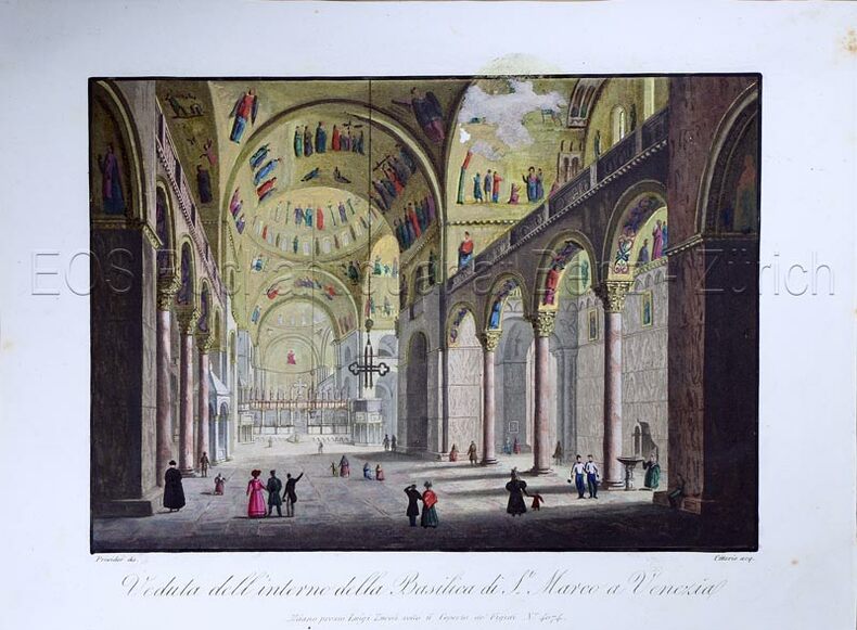
Prividor:
Veduta dell' interno della Basilica di S. Marco a Venezia.
Milano, Luigi Zucolisotto il Coperto de Figuri No. 4074, (um 1820). Altkolorierte Aquatina von Citterio. Bildgrösse: 13,8 x 19,4 cm. Blattgrösse: 18,6 x 25 cm.
Ссылка продавца : 613DG
|
|
|
Price Peter A. & Sketch Maps By The Author
Cotswolds-Southern Area Walks For Motorists9 Warne walking guides
Warne 1985. New edition. Paperback. Used; Good. <p><i><strong>Fast Dispatch. Expedited UK Delivery Available. Excellent Customer Service. </strong></i> <br/><br/>Bookbarn International Inventory #2554552</p> Warne paperback
Ссылка продавца : 2554552 ISBN : 0723221510 9780723221517
|
|
|
Price Peter A. & Sketch Maps By The Author
Wye Valley Walks for Motorists Warne walking guides
Frederick Warne Publishers Ltd 1979. Paperback. Used; Good. <p><i><strong>Fast Dispatch. Expedited UK Delivery Available. Excellent Customer Service. </strong></i> <br/><br/>Bookbarn International Inventory #2554568</p> Frederick Warne Publishers Ltd paperback
Ссылка продавца : 2554568 ISBN : 0723221472 9780723221470
|
|
|
Price Peter A.; Sketch Maps by the Author
Wye Valley Walks for Motorists Warne walking guides
London : Frederick Warne Publishers Ltd 1979. Soft cover. Good/No Jacket as published. 5" x 8. Thirty circular walks around the Wye Valley in western England with maps and photographs. The walks range in length from 2.5 miles 4Km to 7 miles 11Km. Shows some minor reading wear but still clean and sound. All orders processed and shipped promptly from the UK usually the same or next business day. Call or email us with your questions by going to "Bookseller & Payment Information" below and then "Ask bookseller a question" or "View Booksellers Homepage" <br/> <br/> Frederick Warne Publishers Ltd paperback
Ссылка продавца : 018671 ISBN : 0723221472 9780723221470

|
|
|
Pringle JMD. with Maps by Marthe Rajchman J. M.
China Struggles for Unity
Penguin Special 57 5d 1939. 2nd. Mass market paperback. very good with worn d.j. <br/><br/> Penguin Special 57 (5d) paperback
Ссылка продавца : 401938

|
|
|
Pritchard, James B.
THE WATER SYSTEM OF GIBEON. Museum Monographs.
pp. vii, 23 + Plus numerous drawings, maps and photographs of the excavation. 4to. Original printed blue wraps. Very good copy. First excavated by James Pritchard (1956-1962), Gibeon has significant archaeological remains - especially from the days of the early Israelites. First Edition. SCIENCE BOX 3
|
|
|
PRIVAS - ALES
Carte touristique au 1/100 000e.
1 feuille 90x120 cm.
|
|
|
Prividor
Veduta dell' interno della Basilica di S. Marco a Venezia.
Milano, Luigi Zucolisotto il Coperto de Figuri No. 4074, (um 1820). Altkolorierte Aquatina von Citterio. Bildgrösse: 13,8 x 19,4 cm. Blattgrösse: 18,6 x 25 cm. + Wichtig: Für unsere Kunden in der EU erfolgt der Versand alle 14 Tage verzollt ab Deutschland / Postbank-Konto in Deutschland vorhanden +, Bild
Ссылка продавца : 613DG

|
|
|
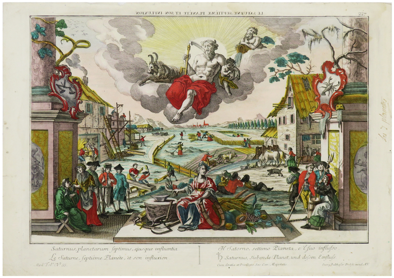
PROBST (Georg Balthasar).
[SATURNE] Le Saturne, septième planète et son influxion.
A.V. pour Augusta Vindelicorum [Augsbourg], [circa 1770]. 315 x 416 mm.
Ссылка продавца : LBW-6266
|
|
|
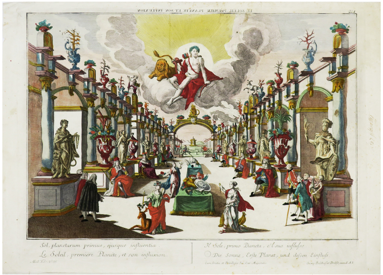
PROBST (Georg Balthasar).
[SOLEIL] Le Soleil, premier planète et son influxion.
A.V. pour Augusta Vindelicorum [Augsbourg], [circa 1770]. 315 x 412 mm.
Ссылка продавца : LBW-6278
|
|
|
PROBST (Joh. Mich.)
Das Konigreich NAPOLI in dessen XII Hauptprovincien….
1730 coloris ancien, un peu passé, cadre bois naturel. carte 47 x 57 cm., 1 grand cartouche colorié, 2 petits cartouches dont l'un donne les blasons des 12 états, en couronne autour du Vésuve. Augspurg Probst Haeredes (ca. 1730)
Ссылка продавца : 13544
|
|
|
PROTESTANTISME par Emile G. LÉONARD.
Histoire générale du Protestantisme volume 3 : déclin et renouveau. Richt documenté (planches, index).
Paris, P.U.F. 1964. Bel exemplaire relié, rel. pleine toile ornée et jaquette d'éd., fort et gd in-8, 786 pages + planches.
Ссылка продавца : AUB-3949
|
|
|
Professeurs de Notre-Dame de France à Jérusalem
La Palestine. La Syrie Centrale, la Basse Egypte, Naples, Athènes, L'Archipel, Constantinople.Guide historique et pratique avec Cartes et Plans nouveaux.
Paris.1922.In-12 en percaline éditeur verte.802 p.Cartes et plans rempliés soulignés de couleurs.BE.Tranches rouges.
Ссылка продавца : 41103
|
|
|
PROCHE-ORIENT sous la dir. De Olivier BINST.
Le LEVANT. Histoire et archéologie du Proche-Orient. Richt doc. (planches en couleurs, fig. cartes).
Ed. Könemann 1999. Bel exemplaire relié, reliure pleine toile et jaquette d'éd., gd in-4, 320 pages.
Ссылка продавца : AUB-6250
|
|
|
PROBST GEORG BALTHASAR.
Pyramides Aegyptiae, miraculum mundi tertium. Les Pyramides de l’Egypte, troisiéme miracle du Monde. I Pyramidi d’Egitto, il terzo miracolo del Mondo. Die Egyptischen Pyramiden, dritte Wunderwerk der Welt.
Augsburg, G.B. Probst, ca. 1780. Engraved and hand coloured vue d'optique. 30 x 40 cm. Mirrored titel with small tear not affecting text. Colours slightly faded, margins a little foxed.
Ссылка продавца : 41637
|
|
|
Professor Hoffmann
The Book of Card Games
1894 George Routledge and Sons, Limited, First Edition 1894. First Edition, un volume in 8 reliure toile rouge, sans jaquette, 311 pages. Mors usés, coins usées, bon état intérieur.
Ссылка продавца : 10121
|
|
|
PROBST GEORG BALTHASAR.
Pyramides Aegyptiae, miraculum mundi tertium. Les Pyramides de l’Egypte, troisiéme miracle du Monde. I Pyramidi d’Egitto, il terzo miracolo del Mondo. Die Egyptischen Pyramiden, dritte Wunderwerk der Welt.
Augsburg, G.B. Probst, ca. 1780. Engraved and hand coloured vue d'optique. 30 x 40 cm. Mirrored titel with small tear not affecting text. Colours slightly faded, margins a little foxed.
|
|
|
Probyn, John Webb.
ITALY: From The Fall of Napoleon I., In 1815, To The Year 1890.
pp. xvi, 312 + Two color maps and a genealogical table of Charles III and Beatrice of Portugal. Foxed. Marbled endpapers. Top edge gold. 8vo. Original half vellum over marbled boards. Spine decorated in gold, reds, purples, greens and black. Marbled edges rubbed with some loss. Hardbound. Handsome binding. First edition published in 1884. Very good. EUROPE BOX 2
|
|
|
Pronti Domenico (1750 - 1815 circa)
Prima Urbis Inter, Divum Domus Aurea Roma
Pianta a proiezione verticale, orientata con il nord in alto, 1769 circa. Si tratta di una piccola e rara riduzione del Nolli. Scaccia Scarafoni cita un esemplare con sottoscrizione Dom. Pront. F. in R(oma) 1770, mentre il nostro esemplare e quello illustrato su Marigliani sono probabilmente prove ante la firma. “Titolo scritto sul piedistallo di una statua in basso a sinistra. In basso a destra veduta di piazza del Popolo. A destra una legenda di 116 numeri su due colonne. La pianta è incisa con cura grafica e dovizia di dettagli a dispetto del formato ridotto; alcune chiese, come ad esempio San Carlo al Corso e ovviamente San Pietro, vengono persino rappresentate con la pianta interna. I lotti edificati sono campiti in nero” (cfr. Marigliani p. 282). Acquaforte, in ottimo stato di conservazione. Bibliografia Scaccia Scarafoni (1939): p. 116, n. 232; Marigliani (2007): p. 282, n. 202. Vertical projection map, oriented with north at the top, circa 1769. This is a small and rare reduction of the Nolli map of Rome (1748). Scaccia Scarafoni mentions an example with subscription Dom. Pront. F. in R(oma) 1770, while our example and the one illustrated on Marigliani are probably proofs, before the imprint. Title written on the pedestal of a statue in the lower left corner. Bottom right view of Piazza del Popolo. To the right a legend of 116 numbers in two columns. The map is engraved with graphic care and abundance of detail despite the small format, some churches, such as San Carlo al Corso and of course St. Peter, are even represented with the internal plan. The built lots are depicted in black (cf. Marigliani p. 282). Etching, in excellent condition. Literature Scaccia Scarafoni (1939): p. 116, n. 232; Marigliani (2007): p. 282, n. 202.

|
|
|
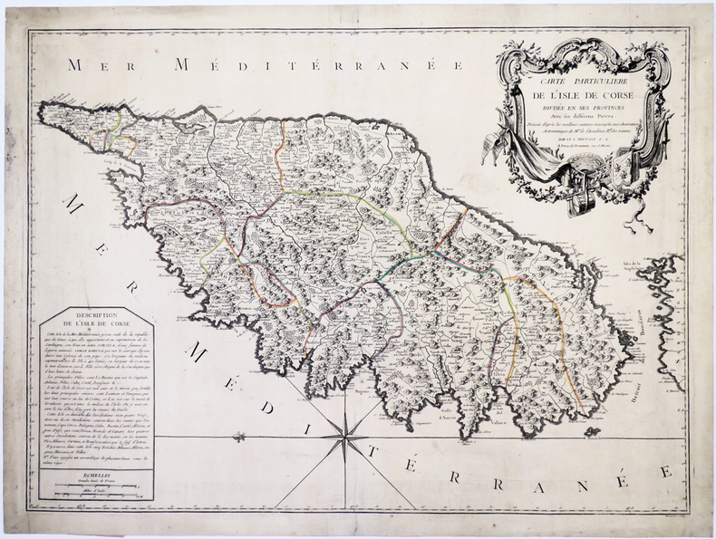
PRUVOST.
[CORSE] Carte particulière de l'isle de Corse divisée en ses provinces avec ses différens pieves.
Paris, Daumont, [circa 1760]. 497 x 681 mm.
Ссылка продавца : LBW-5322
|
|
|
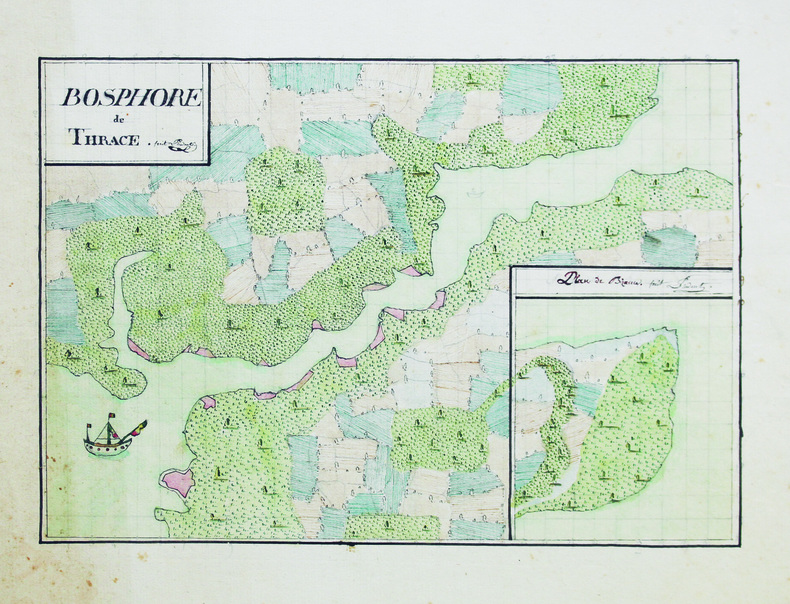
PRUDENT.
Bosphore de Thrace.
[vers 1810]. 20 x 28,5 cm, sur une feuille de 28,3 x 34 cm.
Ссылка продавца : LBW-6613
|
|
|
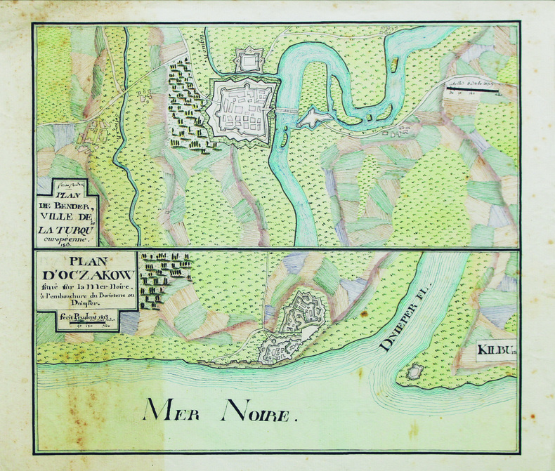
PRUDENT.
Plan de Bender, ville de la Turquie européenne [et] Plan d'Oczakow située sur la mer Noire, à l'embouchure du Boristene ou Dnieper.
1813. 26,5 x 29,5 cm, sur une feuille de 30,5 x 34 cm.
Ссылка продавца : LBW-6615
|
|
|
PRÉVOST D’EXILES (Antoine François Abbé)
Histoire générale des voyages, ou nouvelle collection de toutes les relations de voyages par mer et par terre, qui ont été publiées jusqu'à présent dans les différentes langues de toutes les nations connues, contenant ce qu'il y a de plus remarquable de plus utile et de mieux avéré dans les pays ou les voyageurs ont penetré enrichie de cartes géographiques , de plans , et de perspectives , de figures et d'animaux , de végétaux , habits , Antiquités, etc.
1746 Paris, Didot , libraire quai des Augustins, à la Bible d'Or , 1746, jusqu'à 1789. 20 volumes in-4, Plein veau marbré, dos à nerfs orné. Les 18 premiers renferment l'Histoire générale des voyages publiée par l’abbé Prévost (Paris, Didot, 1746-1759) ; le seizième, la Table alphabétique des matières (Didot, 1761) ; le dix-septième, la Suite de l'Histoire générale des voyages (Amsterdam, Arkstée & Merkus, 1761) ; les 15 sont tous titrés "histoire generale des voyages " le 16 em servant de table des matières .... les 17 jusqu"à 20 sont titrés : "Suite de l'histoire générales de voyages " tous les volumes également enrichis de cartes et plans dépliables .... (Il faut signaler la qualité des pièces dépliantes , dans un état exceptionnel , aucunes dechirées... ) Édition originale de cette immense compilation encyclopédique de voyages, remarquable pour le grand nombre de relations et de documents qu’elle offre sur les découvertes dans les deux Amériques. Cette Histoire a été continuée pour les derniers volumes principalement par Querlon et de Surgy. L'illustration des 20 volumes comprend un portrait de l’abbé Prévost gravé par G. F. Schmidt et plus de 580 planches hors texte gravées sur cuivre d’après Cochin, dont la plupart dépliantes ou à double page. Superbe documentation... parfait état . Rare
Ссылка продавца : 7216
|
|
|
Prévot A.
Notions élémentaires sur les surfaces topographiques et applications aux cartes de France au 1:80000 et au 1:50000
Librairie Vuibert Relié 1934 In-8 (14,8 x 23,5 cm), reliure pleine-toile, dos lisse, pièce de titre, 37 pages, avec deux cartes dont une en couleur ; mouillure sur les bords des premiers feuillets, papier bruni, par ailleurs assez bon état. Livraison a domicile (La Poste) ou en Mondial Relay sur simple demande.
Ссылка продавца : vg325
|
|
|
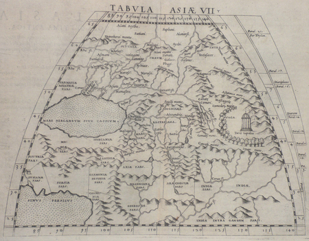
PTOLEMEE Claude & RUSCELLI (Girolamo).
[PERSE] Tabula Asiae VII.
[Venise, 1561]. 185 x 247 mm.
Ссылка продавца : LBW02516
|
|
|
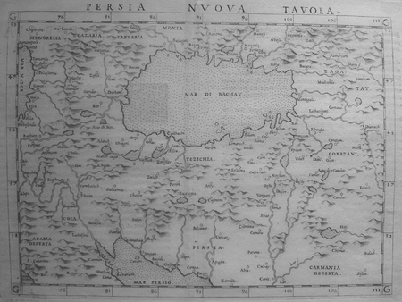
PTOLEMEE (Claude) & RUSCELLI (Girolamo).
[PERSE] Persia nuova tavola.
[Venise, 1561]. 183 x 246 mm.
Ссылка продавца : LBW0251d
|
|
|
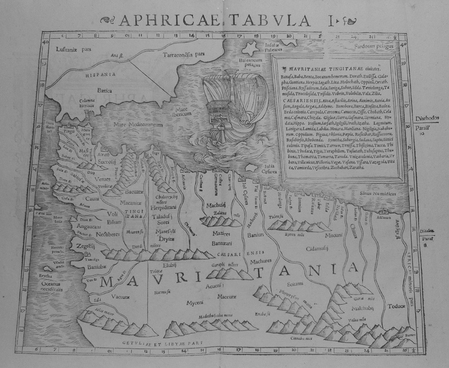
PTOLEMEE Claude & MUNSTER (Sebastian).
Aphricae tabula I.
[Bâle, 1552]. 268 x 333 mm.
Ссылка продавца : LBW01b4b
|
|
|
PTT - Poste suisse:
4 timbres-postes - Boîtes à musique et automates.
Berne, PTT, 1997. Carte de voeux de la Poste suisse, comprenant 4 timbres-poste (valeur 70 + 90 centimes suisses + 1,10 + 1,80 francs suisses). Oblitération du jour d'émission (10.09.1996).
Ссылка продавца : 18504

|
|
|
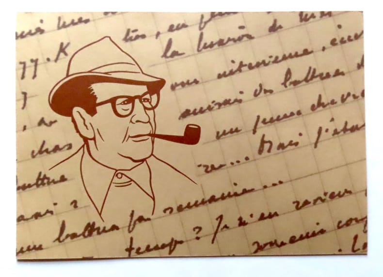
PTT - Poste suisse:
Emission commune Suisse / Belgique / France - Georges Simenon.
Berne, PTT, 1994. Carte de voeux de la Poste suisse, comprenant un timbre-poste (valeur 1 franc suisse) au portrait de Simenon. Oblitération du jour d'émission (15.10.1994).
Ссылка продавца : 18502
|
|
|
PTT - Poste suisse:
Europa 1993. Timbres-poste spéciaux Art contemporain: Architecture.
Berne, PTT, 1994. Carte de voeux de la Poste suisse, comprenant 2 timbres-poste (valeur 60 + 80 centimes suisses). Oblitération du jour d'émission (23.11.1993).
Ссылка продавца : 18503
|
|
|
Published by IMP. HAIRIE et CIE.
[OTTOMAN MAP] [Port of Aden].
Very Good Turkish, Ottoman (1500-1928) Original color map. 21x19,5 cm. In Ottoman script. No scale, no mapmaker info. Slightly dumped on right margin. Little wear on peninsula view. Otherwise a good copy. Folded. [Ottoman map of Aden Bay and Port].
|
|
|
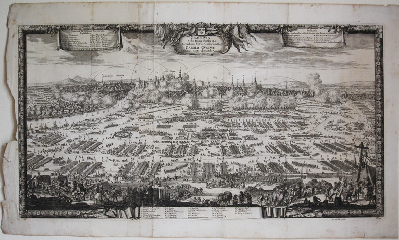
PUFENDORF (Samuel).
[CRACOVIE] Cracovia sedes regia obsessa et a serenissimo Sveo. Gothorum rege Carolo Gustavo ... 1655.
[1696]. 300 x 555 mm.
Ссылка продавца : LBW-2631
|
|
|
PURDY, JOHN.
The New Sailing Directory for the Coasts of Spain and Portugal, from Cape Finisterre to Cadiz, and Thence to the Eastward of Malaga: Composed to Accompany the Chart.
London, Laurie, 1839. 8vo. In contemporary blank wrappers with part of original printed wrapper pasted on. Stamp to front wrapper and title-page. Internally fine and clean. iv, 38 pp.
Ссылка продавца : 57123
|
|
|
PURDY, JOHN.
The New Sailing Directory for the Coasts of Spain and Portugal, from Cape Finisterre to Cadiz, and Thence to the Eastward of Malaga: Composed to Accompany the Chart.
London, Laurie, 1839. 8vo. In contemporary blank wrappers with part of original printed wrapper pasted on. Stamp to front wrapper and title-page. Internally fine and clean. iv, 38 pp.
|
|
|
Putnam, William C.
Map Interpretation with Military Applications
37 pages including index, selected references and black and white illustrations. Average wear. Binding sound. Former U.S. military copy with usual internal markings. No external markings. Solid working copy in maroon cloth-covered boards Book
|
|
|
PUY DE DOME
Carte d?partementale couleurs au 1/200 000e. D?but XXe.
Une feuille 55 x 72 cm repli?e.
|
|
|
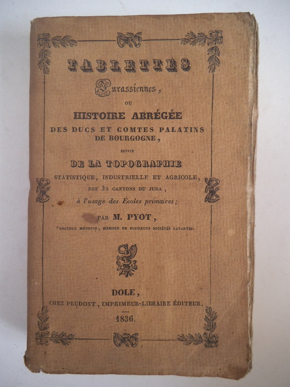
PYOT M.
Tablettes Jurassiennes
ou histoire abrégée des Duc et Comtes Palatins de bourgogne suivie de la topographie statistique , industrielle et agricole des 32 cantons du Jura ; A l’usage des écoles primaires. In 12 broché couverture imprimée faux-titre,carte du département du jura divisé en 32 cantons au verso,titre, (signature de l’auteur)248 pages,catalogue,Dijon 1836 (très pâle mouillure en pied au milieu du volume sans gravité) sinon bon exemplaire
Ссылка продавца : 2493
|
|
|
PYRENEES
Carte guide campbell. N?13 : Pyr?n?es (Bayonne). Echelle 1/320 000?me. Sans date.
Une feuille. 86x68 cm.
|
|
 Получить результаты поиска по электронной почте
 Загрузить результаты в формате PDF
  RSS-канал


