|
ROBERT de VAUGONDY (Didier).
Le Royaume de Pologne, divisé en ses duchés et provinces, et subdivisé en palatinats.
[circa 1750]. 478 x 537 mm.
书商的参考编号 : LBW-1961

|
|
|
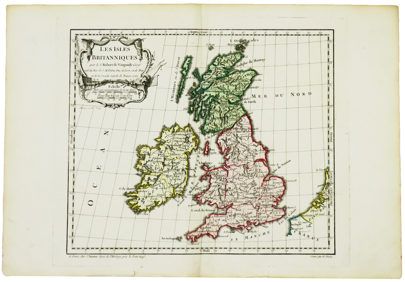
ROBERT de VAUGONDY (Didier).
Les Isles Britanniques.
Paris, chez l'auteur, 1762. 238 x 280 mm.
书商的参考编号 : LBW-5021
|
|
|
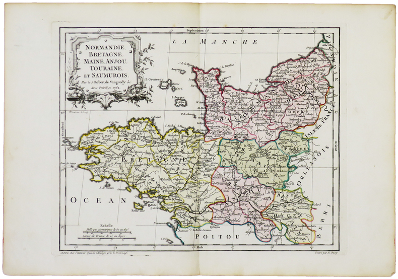
ROBERT de VAUGONDY (Didier).
Normandie, Bretagne, Maine, Anjou, Touraine et Saumurois.
Paris, chez l'auteur, 1762. 238 x 299 mm.
书商的参考编号 : LBW-5032
|
|
|
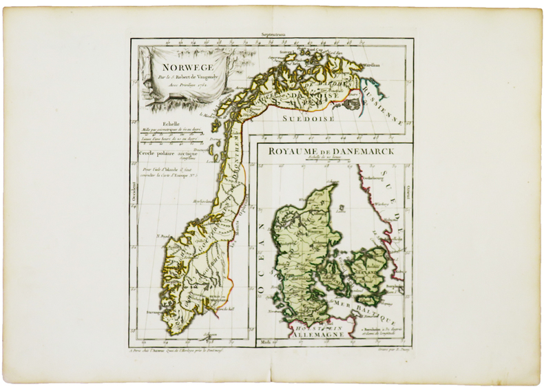
ROBERT de VAUGONDY (Didier).
Norwege - Royaume de Danemarck.
Paris, chez l'auteur, 1762. 238 x 219 mm.
书商的参考编号 : LBW-5025
|
|
|
ROBERT de VAUGONDY (Didier).
Partie orientale de la Haute Guinée.
1749. 164 x 177 mm.
书商的参考编号 : LBW024c1
|
|
|
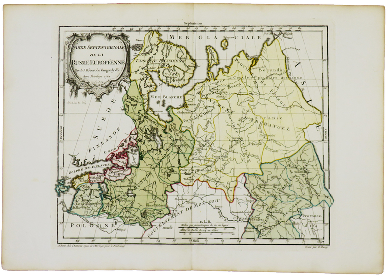
ROBERT de VAUGONDY (Didier).
Partie septentrionale de la Russie européenne.
Paris, chez l'auteur, 1762. 238 x 307 mm.
书商的参考编号 : LBW-5028
|
|
|
ROBERT DE VAUGONDY (Didier).
Plan de la ville et des faubourgs de Paris divisé en ses vingt quartiers.
Paris, chez l'auteur, 1760. En 21 sections montées sur toile et pliées, formant un plan de 578 x 860 mm.
书商的参考编号 : LBW-6946

|
|
|
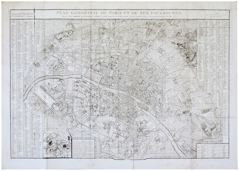
ROBERT DE VAUGONDY (Didier).
Plan géométral de Paris et de ses fauxbourgs.
Paris, Delamarche, 1797. 646 x 949 mm.
书商的参考编号 : LBW-5683
|
|
|
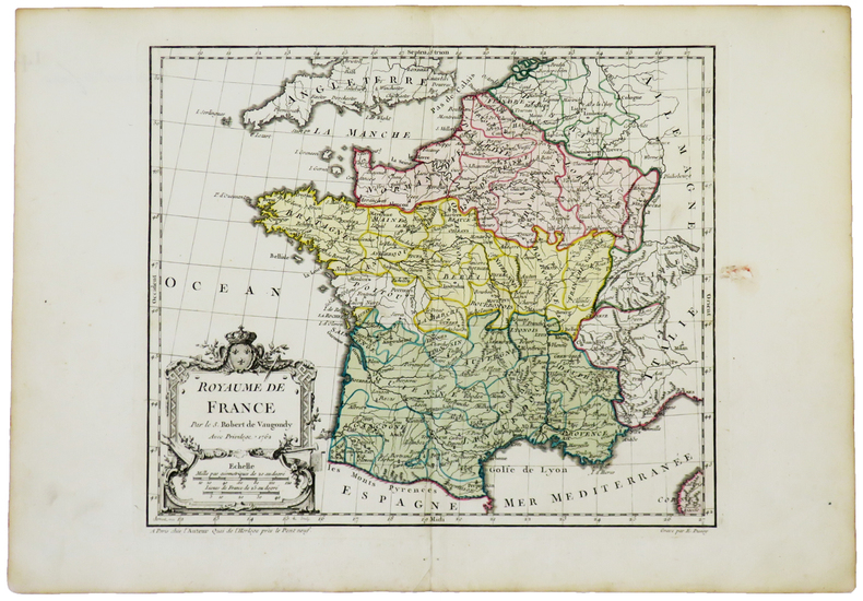
ROBERT de VAUGONDY (Didier).
Royaume de France.
Paris, chez l'auteur, 1762. 238 x 280 mm.
书商的参考编号 : LBW-5031
|
|
|
ROBERT de VAUGONDY (Didier).
Turquie asiatique.
1748. 162 x 195 mm.
书商的参考编号 : LBW02e6e
|
|
|
ROBERT de VAUGONDY (Didier);
[BELGIQUE] La principauté de Liège et le duché de Limbourg.
1754 486 x 454 mm.
书商的参考编号 : LBW03937
|
|
|
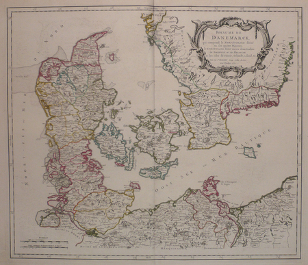
ROBERT de VAUGONDY (Didier);
[DANEMARK] Royaume de Danemarck, qui comprend le Nort-Jutland divisé en ses quatre diocèses, le Sud-Jutland divisé en ses deux duchés de Sleswick et de Holstein, et les isles de Fionie, Selande, Laland, &c.
1750 485 x 565 mm.
书商的参考编号 : LBW03943
|
|
|
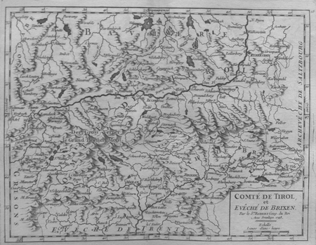
ROBERT de VAUGONDY (Didier);
[TYROL] Comté de Tirol et évêché de Brixen.
1748 161 x 211 mm.
书商的参考编号 : LBW027ac
|
|
|
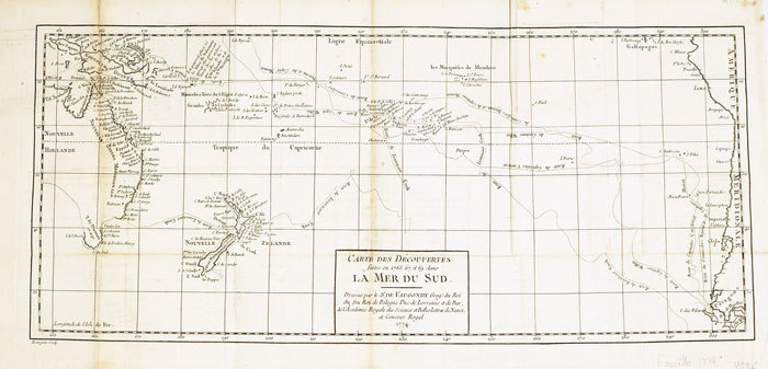
ROBERT de VAUGONDY (Didier);
Carte des découvertes faites en 1765, 67 et 69 dans la mer du Sud.
1774 235 x 535 mm.
书商的参考编号 : LBW-611
|
|
|
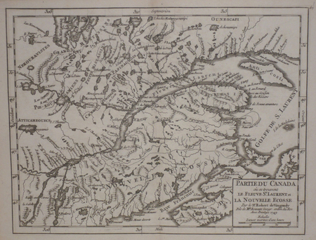
ROBERT de VAUGONDY (Didier);
Partie du Canada où se trouvent le fleuve St. Laurent et la Nouvelle Ecosse.
1749 165 x 216 mm.
书商的参考编号 : LBW024d4
|
|
|
ROBERT de VAUGONDY (Didier);
Royaume de Hongrie.
1749 165 x 221 mm.
书商的参考编号 : LBW027b1

|
|
|
ROBERT de VAUGONDY (Didier);
Royaume de Pologne.
1749 166 x 192 mm.
书商的参考编号 : LBW0253e

|
|
|
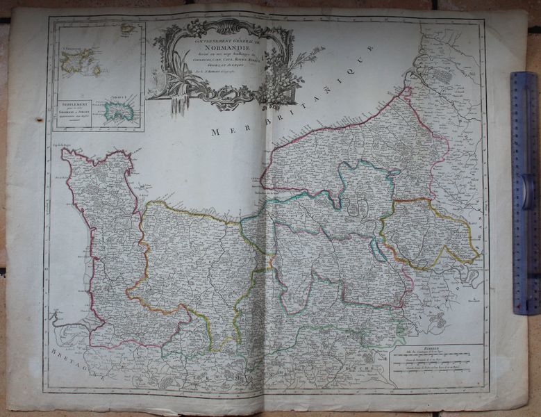
ROBERT DE VAUGONDY (Gilles).
Gouvernement Général de Normandie, divisé en sept baillages, de Coutances, Caen, Caux, Rouen, Evreux, Gisors, et Alençon. Par le Sr Robert Géographe.
S.l. (Paris), Robert, circa 1750. Carte : 77 cm x 56 cm. Titre dans un beau cartouche gravé, limites colorées, pliure centrale, petites déchirures réparées en marge, manque de papier marginal réparé en haut de la pliure.
书商的参考编号 : 17617
|
|
|
ROBERT DE VAUGONDY, Didier
Archipel des Indes Orientales qui comprend les Isles de la Sonde, Moluques et Philippines, tirées des Cartes du Neptune Oriental
Carta geografica colorata a mano (53,5x71), con larghi margini, buone condizioni. Hand coloured map (53,5x71), large margins, good copy.
|
|
|
ROBERT DE VAUGONDY, Didier
Partie Orientale de l’Empire de la Russie en Asie...et le confins de la Tatarie Chinoise
Carta geografica colorata a mano (55x80), larghi margini, qualche macchia al margine inferiore. Geographic map, hand coloured, (55x80), some brownings at the lower margin.
|
|
|
Robert Decker; Barbara Decker; Barbara and Robert Decker Editor; Barbara and Robert Decker Illustrator; Maps and Drawings by Ric
Road Guide To Joshua Tree National Park
Double Decker Press 2006-12-31. Paperback. Very Good. Double Decker Press paperback
书商的参考编号 : 1888898100-2-17347063 ???????? : 1888898100 9781888898101
|
|
|
Robert Decker Barbara Decker Barbara and Robert Decker Editor Barbara and Robert Decker Illustrator Maps and Drawings by Ric
Road Guide To Joshua Tree National Park
Double Decker Press 2006-12-31. Third Edition. Paperback. Good. Double Decker Press paperback
书商的参考编号 : SONG1888898100 ???????? : 1888898100 9781888898101
|
|
|
Robert Fulford
Canada - A Celebration
Inscription opposite half-title page. No other marks. A very clean very tight copy with bright unmarked boards and no bumping to corners. Dust jacket price clipped but not marked or torn with crease to front dust flap. 240pp. The book follows the route of a traveller crossing Canada from East to West, exploring each of the provinces and territories in his path. It is a spectacular depiction of the land of Canada, its history and a verbal tribute to the country's people.

|
|
|
Robert Gambee
Nantucket Island (Signed By Author)
New book still in shrink wrap. Presumably signed before sealing. pp. A photographic album of Nantucket Island off Cape Cod, Massachusetts.

|
|
|
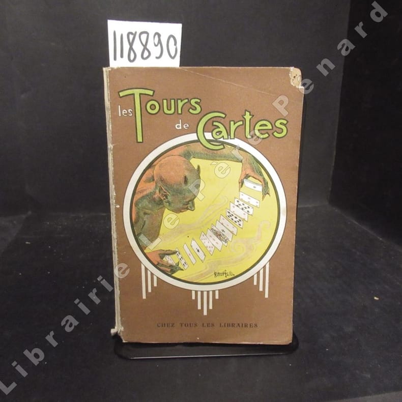
ROBERT, Gaston
Les tours de cartes anciens et modernes des praticiens les plus célèbres. Nouvelle édition.
sd A Paris, Librairie Garnier Frères - Sans date - In-12, broché, couverture illustrée - 171 p. - Illustrations in texte en N&B
书商的参考编号 : 118890
|
|
|
Robert, Gilles:
Partie septentrionale du Comte de Bourgogne ou Franche-Comte, ou sont les Bailliages de Vesoul, Gray, Besancon, Baume, le comte de Montbelliard, et parie des Bailliages de dole, Quingey et Ornans. Grenzkolorierter Kupferstich aus dem Atlas Universel von Robert und Vaugondy
Format (Darstellung): 46,5 x 56 cm. Blatt: 52 x 80 cm. Landkarten de
|
|
|
Roberta Bernstein , Edith Devaney
Jasper Johns : Une forme de ressemblance avec le vrai
, Fonds Mercator 2017, 2017 Hardcover, 263 pages, Texte en Francais, 300 x 280 mm, Tres belle exemplaire ! Beaucoup illustrations de couleur,. ISBN 9789462301894.
书商的参考编号 : 56174
|
|
|
Roberts, Brian K.
Making of the English Village, The: A Study in Historical Geography
Book is in excellent condition. Binding is solid and square, covers have sharp corners, exterior shows no blemishes, text/interior is clean and free of marking of any kind. Contents include: Anatomy of the village, Row plans, Archaeology of villages, Composite village plans, Dominants and details, with a great many maps of all kinds. Book "shows how (Village) plans can be dissected, analysed and dated, demonstrates the presence of important regional contrasts, examines the processes creating, altering and destroying plays through time..." Copyright 2011 Pistil Books
|
|
|
Roberts, Tony & Elizabeth
See the Lleyn Peninsula
No marks or inscriptions. No creasing to covers or to spine. A very clean very tight copy with bright unmarked boards and no bumping to corners. 64pp.

|
|
|
ROBERTSON IAN; Maps and plans by LONDON DOUG
CYPRUS: BLUE GUIDE
LONDON / NEW YORK: A & C BLACK/W. W. NORTON. G IN WRAPS. REMAINDER MARK. RUBBED. Pages: 216. . 1987. 2ND. TRADE PAPERBACK. A & C BLACK/W. W. NORTON paperback
书商的参考编号 : MASTER089099I
|
|
|
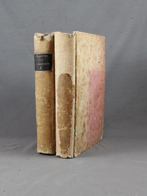
ROBERTSON M.:
L’Histoire de l’Amérique.
A Paris, Chez Panckoucke, 1778. 2 volumes in-8 de XX-540 + 526 pages, cartonnage rose à motifs, étiquette de titre noire. Mors fendus, dos et plats passés, coiffes manquantes, manques aux dos, plats tachés, coins frottés.
书商的参考编号 : 2141
|
|
|
ROBERTSON, William
Histoire de l’Amerique
Tre voll., in -8°, pp. XXXI, 487; 539; 513; pelle con fregi, tasselli e titoli al dorso. Completo delle cinque tavole ripiegate, di quattro carte e una tavola, “Table chronologique des Mexicains”. Complete of five folding plates, four geographic maps and a non folding plate: “Table chronologique des Mexicains”.
|
|
|
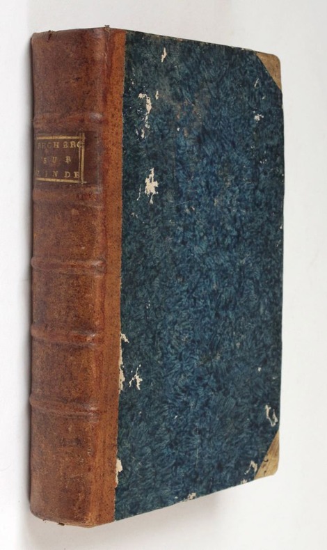
Robertson, William
Recherches historiques sur la connoisance que les anciens avoient de l'Inde et sur les progrès du commerce avec cette partie du monde avant la découverte du passage par le Cap de Bonne-Espérance (...) Avec deux grandes cartes gravées en taille-douce.
1792 Paris, Buisson, 1792. 20 x 12,5 cm, in-8, VIII - 536 pp. - 2 grandes cartes dépliantes gravées en taille douce sur vergé bleuté (carte de la partie sud-est de l'Asie selon Ptolémée, et une autre selon les connaissances géographiques récentes), reliure de l'époque en demi-basane fauve à petits coins en vélin, dos à 5 nerfs, pièce de titre, tranches mouchetées.
书商的参考编号 : 515
|
|
|
Robin Fedden & John Kenworthy Browne Blank endpapers ink mrkout Preface Glosssary Maps Acknowledgment Index illustrated C
Country House Guide The introducing over 200 privately owned Historic Houses in England Wales & Scotland To The Public
W. W. Norton NY 1979. HBDJ 1979 stated 1st US Edition cloth cover lettered Gold Gilt spine minor Wear PC DJ minor Rub Wear Interior Nice Tight Clean 431 pgs NF/NF AS-IS. First Edition. Hard Cover. W. W. Norton NY hardcover
书商的参考编号 : 9577
|
|
|
ROBINSON NANCY with illustrations by FRANCIS JILL and maps by DOWLER IAN
RELUCTANT HARBOUR - The Romance of Pirie
Nadjuri Jamestown SA 1976. 327 pp including index maps on end papers b&w photographic and line illustrations maps fine copy in illustrated laminated boards. Nadjuri, Jamestown SA, 1976 hardcover
书商的参考编号 : 230417
|
|
|
Robinson Patrick. Spain Justin Maps
Shark Mutiny; Admiral Arnold Morgan Book 5
New York New York U.S.A.: HarperTorch/HarperCollins Publisher 2002. Near Fine 1st Printing Stated Mass Market Paperback 490 pages Binding is solild; slight spine crease; spine is slightly concaved; no crease to covers corners; slight edge wear; pages are clean no marks to text no owner information gift messages store stamps remaimder marks stains or moisture damage. ' In partnership with Iran the Chinese navy has mined the Strait of Hormuz intending to hold the world's oil supply hostage. Now eighty percent of America's active sea power is being mobilized--including U.S.S. Shark an aging nuclear submarine on its final tour of duty--to dismantle a deadly alliance between two powerful enemies. But something goes terribly wrong during a bold retaliatory SEAL assault on China's Indian Ocean power plants--a disaster that spawns death disbelief rage and rebellion. And with a volatile world on the brink of catastrophic conflict the commanders of a nuclear boat must confront a nightmare as devastating as it is unthinkable: mutiny.' Have in paperback; U.S.S. SEAWOLF; SHARK MUTINY; Will gift wrap no charge just state the occasion. 1st Printing. Mass Market Paperback. Near Fine/No Jacket. Illus. by Justin Spain Maps. 12mo - over 6�" - 7�" tall. HarperTorch/HarperCollins Publisher Paperback
书商的参考编号 : 001734 ???????? : 006103066X 9780061030666

|
|
|
ROBIQUET (Aimé).
[GOLFE du LION] Côtes de France sur la Méditerranée. Golfe de Lyon d'après les travaux exécutés dans les années 1839 à 1846.
Paris, Robiquet, 1856. 610 x 894 mm.
书商的参考编号 : LBW-8305

|
|
|
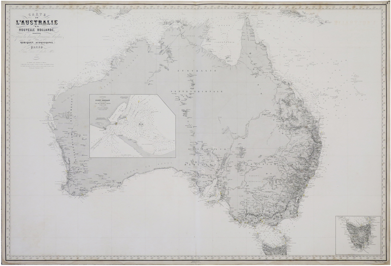
ROBIQUET (Aimé).
Carte de l'Australie ou Nouvelle Hollande, dressée d'après les derniers documents anglais.
Paris, 1863. 0,68 x 1 m.
书商的参考编号 : LBW-6812
|
|
|
Robson EI. Text Howard JR. E. Maps & illustrations E. I. J. R.
A WAYFARER ON THE LOIRE.
BOSTON: HOUGHTON MIFFLIN AND COMPANY. Very Good in Very Good dust jacket. 1926. First Edition; First Printing. Hardcover. First American edition. Very good copy in a very good dust jacket. Light traces of shelf soiling at edges of text. Shallow chipping at spine ends on jacket. A few short edge tears in. Uncommon in jacket. ; 220 pages . HOUGHTON, MIFFLIN AND COMPANY. hardcover
书商的参考编号 : 311928
|
|
|
Robson, John
Captain Cook's World. Maps of the Life and Voyages of James Cook R.N.
New Zealand, Random House, 2000. 211 p. with 128 maps and a gazetteer. 30,5 x 25 cm, hardcover with original wrappers.
书商的参考编号 : 23956
|
|
|
ROCHE Aimé O. M. I:
Clartés Australes Joseph Gérard, O. M. I. Le "Prêtre bien-aimé des Basotho" (1831-1914) Préface de Son Em. Mgr. Feltin, Archevêque de Paris.
Lyon, Éditions du Chalet, 1951. In-8 de 396-[4] pages, pleine basane caramel, premier plat orné d'une composition figurant deux cases et de la végétation, dos lisse, couvertures conservées.
书商的参考编号 : 19753
|
|
|
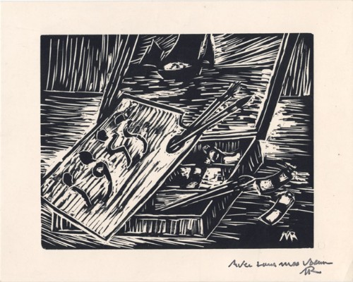
Roche, Marcel
Marcel Roche : carte de voeux pour 1955 et gravure originale
1955 Carte de voeux de Marcel Roche pour l'année 1955. Carte de 12 x 15 cm, portant une gravure sur bois en noir enrichie d'un mot autographe signé de l'artiste.
书商的参考编号 : 1477
|
|
|
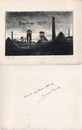
Roche, Marcel
Marcel Roche : carte de voeux pour 1957 et gravure originale
1957 Carte de voeux de Marcel Roche pour l'année 1957. 14,5 x 19 cm, 2 ff., en deuxième page une gravure en noir représentant un paysage minier, numérotée 58/75 et signée à la mine de plomb, en troisième page un envoi autographe signé à la plume.
书商的参考编号 : 1053
|
|
|
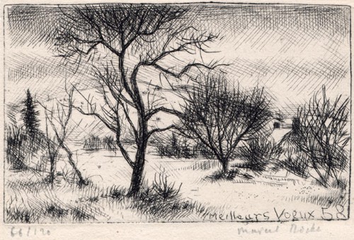
Roche, Marcel
Marcel Roche : carte de voeux pour 1958 et gravure originale
1958 Carte de voeux de Marcel Roche pour l'année 1958. 10 x 14,5 cm, 2 ff., en page 3 une gravure en noir, numérotée 66/120 et signée à la mine de plomb, le reste muet.
书商的参考编号 : 1476
|
|
|
Rochford, Noel
Landscapes of Corfu
No marks or inscriptions. Crease to lower corner of front cover, none to spine. A very clean very tight copy with bright unmarked boards and no bumping to corners. Large pull-out map in excellent condition. 128pp. Walking tours in Corfu plus car trips and picnic places.

|
|
|
Rochford, Noel
Landscapes of Lanzarote
No marks or inscriptions. No creasing to covers or to spine. A very clean very tight copy with bright unmarked boards, slight fading near spine and no bumping to corners. Large pull-out map in excellent condition. 70pp. Walking tours in Lanzarote plus car trips and picnic places.

|
|
|
Rocque John
A Plan of Rome… / La Topographia di Roma da G. B. Nolli… / Plan de Rome...
Pianta di Roma a proiezione verticale, orientata con il nord in alto.Incisa da R. Benning per il cartografo inglese John Rocque e basata sulla pianta di Giovan Battista Nolli del 1748."Come annunciato nel titolo (ripetuto anche in italiano e francese), si tratta di una diretta derivazione della pianta piccola del Nolli che l'autore ha voluto riportare nella scala in cui aveva già pubblicato la pianta della città di Londra. In basso a sinistra indice delle fabriche più ragguardevoli contenute nella pianta con 170 voci suddivise in sei colonne. In basso a destra dedica a Sir. Bouchier Wrey. Le emergenze architettoniche sono campite in nero ed il resto degli isolati a tratteggio diagonale. In basso a sinistra il nome dell'incisore R. Benning sc. La stessa pianta fu rstampata nel 1773 dal Sawyer" (cfr. Marigliani p. 274).Acquaforte, finemente colorata a mano, in buono stato di conservazione. Non comune. Vertical projection map of Rome, oriented with the north at the top.Published in 1750 by John Roque, from the earlier plan by Goivanni Battista Noli published in 1748 (These dates are printed on the map).As announced in the title (also repeated in Italian and French), this is a direct derivation of the small map of Nolli that the author wanted to bring back to the scale in which he had already published the map of the city of London. At the bottom left index of the most remarkable fabrications contained in the plan with 170 entries divided into six columns. Bottom right dedication to Sir. Bouchier Wrey. The architectural buildings are in black and the rest of the blocks are in diagonal hatching. Bottom left the name of the engraver R. Benning sc. The same plan was printed in 1773 by Sawyer (see Marigliani p. 274).Etching, finely colored by hand, in good condition. Not common. C. Marigliani, "Le Piante di Roma delle collezioni private", n. 192; Scaccia Scarafoni, "Le Piante di Roma", n. 230.

|
|
|
Roddy, H. J.
PHYSICAL & INDUSTRIAL GEOGRAPHY OF LANCASTER COUNTY, PENNSYLVANIA.
115 p. + Half tone photographic illustrations; + Folding Maps. Tall 8vo. Original cloth backed printed paper boards. Binding worn and slightly soiled. Scarce. PA 24 x2
|
|
|
Roderick MacFarquhar
The Forbidden City
No marks or inscriptions. A very clean very tight copy with bright unmarked boards and no bumping to corners. Dust jacket not price clipped or marked or torn or creased with very minor traces of storage. 172pp. With nearly 150 illustrations, many in colour, this account describes China's Forbidden City which only became accessible to all Chinese citizens after the 1911 revolution.

|
|
|
Roe F. Gordon historical text; Fen Emberton decorative maps
Britain's Birthright
London: P. R. Gawthorn Ltd. Post-war but not later than 1950 because of the Christmas 1950 inscription. A superb historical introduction to Britain famous and not-so-famous beauty spots with many colour photos. Spine is worn away at very bottom and top. Corners bumped. . Cloth. Good-/No Jacket. P. R. Gawthorn, Ltd. Hardcover
书商的参考编号 : 09580
|
|
 ?????????
 ?????PDF???
 RSS feed


