|
DANKERTS Justus (1635-1701)
Roma
Rara veduta prospettiva della città vista da Monte Mario. L'incisione è tratta dalla veduta incisa da Dominique Barriere nel 1649, rispetto alla quale risulta in controparte. "In alto, sopra il titolo, si vede lo stemma SPQR sormontato da una corona. IN basso a sinistra 12 righe di testo ed a destra una legenda di 42 numeri. Solo San Pietro è riconoscibile (neppure Castel Sant'Angelo lo è) da cui si deduce che la veduta è stata copiata e non realizzata dal vero; a conferma di questo la rappresentazione in controparte. Il prototipo da cui è tratta è la veduta incisa da Dominique Barriere nel 1649 con la quale peraltro coincidono anche i numeri e le voci di legenda. Già il De Jonghe aveva comunque realizzato nel 1665 una derivazione assai fedele del panorama del Barriere ed è probabile che a questa si sia rifatto il Dankerts" (cfr. Marigliani p. 211). Incisione su rame, in buono stato di conservazione.Non censita dai principali repertori. Rare perspective view of the city seen from Monte Mario. The panroama is taken from the view engraved by Dominique Barriere in 1649, to which it is in counterpart. At the top, above the title, we see the coat of arms SPQR surmounted by a crown. At the bottom left 12 lines of text and at the right a 42-number legend. Only St. Peter's is recognisable (not even Castel Sant'Angelo is recognisable) from which we deduce that the view was copied and not made from life; this is confirmed by the representation in counterpart. The prototype from which it is taken is the view engraved by Dominique Barriere in 1649, with which, moreover, the numbers and items in the legend also coincide. De Jonghe had already made a very faithful derivation of Barriere's view in 1665, and it is likely that Dankerts drew on it (cf. Marigliani p. 211). Engraving on copper, in a good state of preservation. Not listed in the main repertories. C. Marigliani, Le Piante di Roma…, p. 211, n. 117.

|
|
|
DANMARKSKORT - DE L'ISLE, (GUIALLAUME).
Carte du Royaume de Danemarc.
Paris, chez Dezauche succ. De L'Isle et Buache, 1780. 49,5x65,5 cm. Kobberstukket kort over Danmark med Skåne, Halland og blekinge. Original konturkolorering. Brede marginer med mindre rifter.
|
|
|
DANMARKSKORT - DELISLE, GUILLAUME.
Carte du Royaume de Danemarc.
Amsterdam, Covens et Mortier, c. 1710-33. 49x60,5 cm. Kobberstukket Danmarkskort med Skåne, Halland og Blekinge. På svært papir og med original fuld håndkolorering. Frisk eksemplar.
|
|
|
DANMARKSKORT - J.B. HOMANN.
Regni Daniae in quo sunt Ducatus Holsatia et Slesvicum Insulae Danicae, Provinciae Iutia Scania Blekingia... Nova Tabula... Iohann Hübneri.
Nürnberg, (ca. 1740). Kobberstukket Danmarkskort med samtidig håndkolorereing, 49,5x59 cm. Visende også Skåne, Halland og Blekinge og i øverste højre hjørne stor kartouche med rigsvåbnet. Kortet er indrammet under glas i fin ramme af brun birkefiner.
|
|
|
DANMARKSKORT - TARCIEU, P.F.
Royaume de Danemarck. Deuxieme Carte. Dannemarck propre Le Jutland et les Isles.
(Paris, u.år ca 1800). 33,5 x 44 cm. Kobberstukket Danmarkskort, frisk velbevaret og konturkoloreret. Brede marginer. (P.F. Tardieu sculpsit - P.J. Valet scripsit).
|
|
|
DAPPER (Olfert).
Description de l'Afrique, contenant les noms, la situation et les confins de toutes ses parties, leurs rivières, leurs villes et leurs habitations, leurs plantes et leurs animaux ; les mœurs, les coutumes, la langue, les richesses, la religion et le gouvernement de ses peuples. Avec des cartes des états, des provinces et des villes, et des figures en taille-douce, qui représentent les habits et les principales cérémonies des habitants, les plantes et les animaux les moins connus. Traduit du flamand d'O. Dapper, D.M.
Amsterdam, Wolfgang, Waesberge, Boom & van Someren, 1686. In-folio en reliure pastiche à l'imitation du XVIIIe, en veau, dos à nerfs orné, pièce de titre, 4 ff. (Titre frontispice allégorique gravé, titre, préface, table,) 534 pp., 11 ffnch.. Ouvrage illustré d'une grande carte dépliante de l'Afrique, de 11 cartes doubles, de 25 gravures doubles (plans, sites, costumes et coutumes) et de 55 gravures in-texte à mi-page (complet),il manque 5 planches ; les pyramides d'Égypte - La Casse, le Datura- Tanger - la Basse Éthiopie - Valette, ville neuve de Malte. Le texte est complet avec quelques erreurs de pagination.
Referência livreiro : PHO-1727

|
|
|
DARCHE, Claude.
Initiation pratique au Tarot. Tirages et interprétations divinatoires à la portée de tous.
St-Jean-De-Braye, Dangles (collection "Initiation"), 1992. In-8, broché, couverture illustrée, 196 pages.
Referência livreiro : 83622

|
|
|
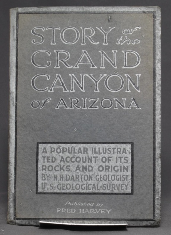
DARTON N. H:
Story of the Grand Canyon of Arizona. A popular illustrated account of its rocks and origin.
Kansas City, Fred Harvey, sans date. In-8 broché de 74-[6] p., couverture grise imprimée noir et argent.
Referência livreiro : 6257
|
|
|
Darby, Ben
Journey Through the Weald
No marks or inscriptions. A lovely clean very tight copy with bright unmarked boards and no bumping to corners. Dust jacket not price clipped or marked or torn or creased with slight traces of handling. 207pp. A descriptive, historical, geological, natural, architectural tour of the Weald from Romney Marsh to the village of Selbourne.

|
|
|
Dard, Antoine
Chez les ennemis d'Israël. Amorrheéns - Philistins. Hors texte, Cartes et Illustrations.
Paris, Victor Lecoffre 1906. (6) 331 (2) Seiten, mit mehreren Abbildungen auf Tafeln, Kl. 8° (17,5 x 12 cm), Priv.-Halbleineneinband.
Referência livreiro : 40636

|
|
|
Dardanellen.
Hellespont ou Detroit des Dardanelles pour servir de renseignement a la Carte des Limites des trois Empires ou Théatre de la Guerre presente 1788. [Paris], o. Dr., 1788.
Gest., alt ankolorierte Karte, Plattenmaß 645:295 mm (Blattmaß 666:340 mm). Unter Passepartout (800:455 mm). Zeigt die 65 Kilometer lange Meerenge der Dardanellen zwichen Ägäis und Marmarameer. Vier zusätzliche kleine Pläne (je 75:54 mm) zeigen "Les Forts des Dardanelles armes in Guerre", nämlich den "nouveau chateau d'Asie construit en 1658", den "nouveau chateau d'Europe construit en 1658", den "vieux chateau des Dardanelles en Asie" sowie den "vieux chateau d'Europe ou Dardanelle". 1788 trat Österreich in den Russisch-Türkischen Krieg ein. - Mit zeitgenössischem grünem Grenzkolorit. BM Cat. Maps 43980 (4).

|
|
|
Darlington, William.
FLORA CESTRICA. An Herborizing Companion for the Young Botanists of Chester County. Third Edition.
pp. 598 + Colored Map. XLib. (withdrawn). Some foxing and damp stain. Original full leather binding. Front board and spine almost detached. Early ownership of J.G. Getchell. William Darlington (1782-1863) was a Chester County physician and botanist, and a member of the U.S. House of Representatives from PA. He became a botanist at an early age, studied medicine, and graduated from the medical department of the University of Pennsylvania at Philadelphia in 1804. He went to the East Indies as ship's surgeon in 1806. He returned to West Chester in 1807 and was a practicing physician there for a number of years. He raised a company of volunteers at the beginning of the War of 1812 and was major of a volunteer regiment. Darlington was elected as a Democratic-Republican to the Fourteenth Congress; the Sixteenth; and the Seventeenth Congresses. He was appointed canal commissioner in 1825, and served as president of the West Chester Railroad. He established a natural history society in West Chester in 1826 and published several significant works on botany and natural history. Sabin 18596. The best edition. PA22
|
|
|
DAUMONT (Jean-François).
[BOMBAY/MUMBAI] Vista en perspectiva de la isla de Bombay en Africa, cerca de la costa de Malabar, Reyno de Visapour, baxo la dominacion del Rey de la Gran Bretaña.
Paris, Daumont, [circa 1770]. 486 x 339 mm.
Referência livreiro : LBW-4004

|
|
|
DAUSSY (Pierre).
[MARSEILLE & PIOMBINO] Carte des côtes de la mer Méditerranée. Partie comprise entre Marseille et Piombino.
[Paris], Dépôt-Général de la Marine, 1832. 605 x 885 mm.
Referência livreiro : LBW-8314

|
|
|
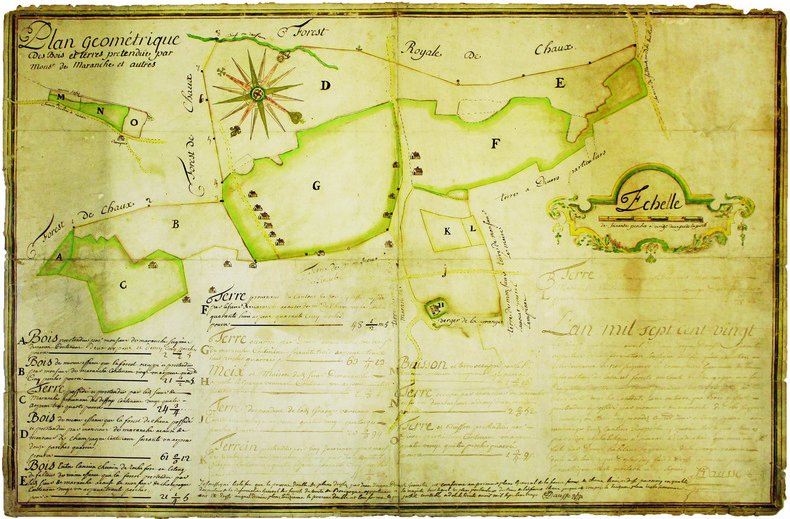
DAUSSE (Jean-Jacques). MANUSCRIT.
Plan géométrique des bois et terres prétendue par Monsr de Maranche et autres.
1720. 510 x 778 mm, monté sur toile.
Referência livreiro : LBW-4140
|
|
|
DAUPHINÉ par Paul VEYRET, R. AVEZOU, R. FERNANDAT, P. VAILLANT ...
Visages du Dauphiné. Richement documenté (héliogravures, planches en couleurs, figures, cartes).
Paris, éd. Horizon de France 1949. Bel exemplaire broché, pet. in-4 carré, 207 pages + planches.
Referência livreiro : AUB-4575
|
|
|
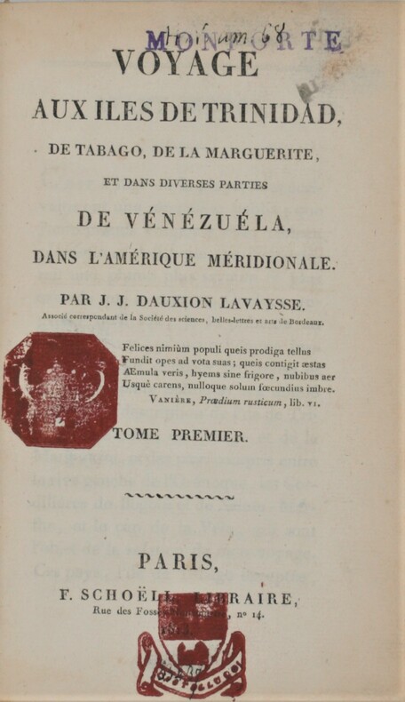
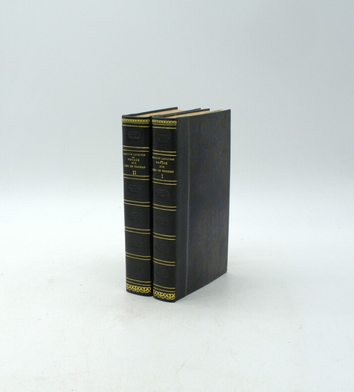
Dauxion-Lavaysse , Jean-Joseph
Voyage aux îles de Trinidad, de Tabago, de la Marguerite et dans diverses parties de Vénézuéla, dans l'Amérique méridionale.
Paris, F. Schoëll, Libraire, 1813. In-8 (20,5 x 13,5 cm),XXVI-411 pp.,3ff-480pp-4ff (table et errata), illustré de 3 cartes déplantes et 5 tableaux dépliants .Reliure de l'époque demi-basane havane, dos lisse orné, manque au dos ,un plat détaché ,charnières faibles, cachets répétés, déchirure au pli à 1 carte. Édition très rare.
Referência livreiro : PHO-844
|
|
|
DAUXION-LAVAYSSE, Jean-Joseph
Voyage aux îles de Trinidad, de Tabago, de la Marguerite et dans diverses parties de Vénézuéla, dans l'Amérique méridionale.
Paris, F. Schoëll, Libraire, 1813. In-8 (20,5 x 13,5 cm), XXVI-411 pp.,3ff-480pp-4ff (table et errata), illustré de 3 cartes dépliantes et 6 tableaux dépliants, demi-maroquin moderne à long grain bleu nuit, dos lisse, auteur, titre et tomaison dorés, filet et roulette dorés, fers à froid rousseurs.
Referência livreiro : PHO-1916
|
|
|
Dauphin County Parks.
COMPREHENSIVE PARK, RECREATION AND OPEN SPACE PLAN FOR DAUPHIN COUNTY.
np. Zerox copy. Illustrated with photographs and large folding maps. 4to. Original spiral bound wraps. PA PAMPH 20_7 BX2
|
|
|
Davenport Maps Ltd.
Street & Recreational Guide of South Vancouver Island
2017-02-07. New. Ships with Tracking Number! INTERNATIONAL WORLDWIDE Shipping available. May be re-issue. Buy with confidence excellent customer service! unknown
Referência livreiro : 1896888127n ISBN : 1896888127 9781896888125

|
|
|
Davenport, Bishop.
A NEW GAZETTEER, OR GEOGRAPHICAL DICTIONARY. Of North America And The West Indies. A New Edition With Alterations And Additions.
536 p. LACKS folding map. Lacks front fly leaves. Text illustrations. XLib blind stamp of A. Herr Smith Memorial Library on title page. XLib stamp of Free Public Library, Lancaster, PA on title page. XLib stamp on all edges. First three signatures damp stained on bottom corner. Foxed. First four leaves including title page chipped at edges. 8vo. 235 mm. Original full leather binding, worn. Front board fragile. Hardbound. Fair. S&S/AI 55257. PAIMP 10
|
|
|
David and Ruth Whitehouse; with maps drawn by John Woodcock & Shalom Schotten
ARCHAEOLOGICAL ATLAS OF THE WORLD with 103 Maps
Thames and Hudson London 1975 softcover 6�" x 9�" Previous owner's name to front endpaper. Book in VERY GOOD condition In this single volume there are over a hundred specially-drawn maps pinpointing more than 5000 sites and accompanied by explanatory texts. The atlas is divided into seven sections each prefaced by a commentary on the period or territory covered. Superimposed on each map is a standardized grid by means of which the exact location of every site can immediately be found by consulting the index at the end of the volume. Thames and Hudson, London paperback
Referência livreiro : 40119
|
|
|
David Biggs
This is Cape Town
No marks or inscriptions. A very clean very tight copy with bright unmarked boards and no bumping to corners. Dust jacket not price clipped or marked or torn with rubbing to top of spine and minor traces of storage. 160pp. A lavishly illustrated study of Cape Town in South Africa beginning with a detailed profile of the city and superb colour photographs showing the landscape and seascape, the culture, the buildings and the people.

|
|
|
David Butler; Photos Maps Illustrator
The Fall of Saigon: Scenes from the Sudden End of a Long War
Simon & Schuster 1985-04-01. Hardcover. Acceptable. Simon & Schuster hardcover
Referência livreiro : 0671466755-4-17675537 ISBN : 0671466755 9780671466756
|
|
|
David Butler Maps Photos Illustrator
The Fall of Saigon: Scenes from the Sudden End of a Long War
Simon & Schuster 1985-04-01. Hardcover. Used:Good. Simon & Schuster hardcover
Referência livreiro : DADAX0671466755 ISBN : 0671466755 9780671466756
|
|
|
David Lavender; Illustrator Illustrated by maps
The Rockies
Harper & Row Publishers 1968. First Edition. Hardcover. Good. 1968 Harper and Row hard cover with price clipped dust jacket stated first edition has a fold out map last page has a small taped tear bottom edge is dented corners are worn dust jacket is in mylar from a private collector has a small yellow sticker that says signed on the spine binding is strong scans available on request b109 Harper & Row, Publishers hardcover
Referência livreiro : 010812002
|
|
|
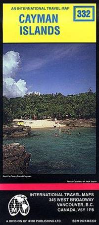
David Sami Jack Joyce International Travel Maps Jack Joyce Editor
Cayman Islands Map by ITMB International Travel Maps
Itmb Publishing Ltd 1996-01-01. 1. Map. Used:Good. Itmb Publishing Ltd unknown
Referência livreiro : DADAX0921463332 ISBN : 0921463332 9780921463337
|
|
|
David Saville Muzzey; Illustrator photos and pictures. Some color Maps b&w drawings
A History of Our Country
Ginn and Co 1936. Hardcover. Very Good. Ginn and Co hardcover
Referência livreiro : 100420018
|
|
|
David Watson Maps by Rosemary Watson
Family-Friendly Walks Cartmel Peninsula. Map Guide
Sheet map. New. unknown
Referência livreiro : ria9780956521873_new ISBN : 0956521878 9780956521873
|
|
|
David Watson Maps by Rosemary Watson
Family-Friendly Walks Cartmel Peninsula. Map Guide
Sheet map. As New. unknown
Referência livreiro : ria9780956521873_rkm ISBN : 0956521878 9780956521873

|
|
|
David Watson Maps by Rosemary Watson
Walks from the Keswick Launch. Map Guide
Sheet map. New. unknown
Referência livreiro : ria9780956521859_new ISBN : 0956521851 9780956521859
|
|
|
David Watson Maps by Rosemary Watson
Walks from the Keswick Launch. Map Guide
Sheet map. As New. unknown
Referência livreiro : ria9780956521859_rkm ISBN : 0956521851 9780956521859
|
|
|
David, Joy (editor)
The Hidden Places of North Yorkshire
No marks or inscriptions to contents. No creasing to front cover or to spine, small crease to lower corner of rear cover. A very clean very tight copy with bright boards, slight damp effect to part of rear fore-edge and no bumping to corners. Fold-out map at rear in excellent condition. 216pp. An easily used book which takes you on a gentle meander through the beautiful countryside of North Yorkshire. As well as some of the well-known tourist attractions are those little known features which are so easily missed.

|
|
|
Davidson B.; photos maps drawings Illustrator
THE LOST CITIES OF AFRICA K4
Little Brown and Company 1959-01-01. Paperback. Very Good. Little, Brown and Company paperback
Referência livreiro : 200605031
|
|
|
Davidson, Marshall B. and McTigue, Bernard.
TREASURES OF THE NEW YORK PUBLIC LIBRARY.
304 p. Numerous photographic illustrations by Jonathan Wallen. 4to. Original full cloth binding. Dust jacket. First Edition. Published at $60.00. Fascinating tour through the collections of one of the greatest American libraries. The New York Public Library houses more than 8 million volumes, 23 million manuscripts and half a million recordings. Includes: Washington's Farewell Address; the first Gutenberg B ible ever brought to this hemisphere; rare globes and maps; musical scores; and much more. A lavish history. **PRICE JUST REDUCED! REF1
|
|
|
Davis Burke/Palacios Rafael D. maps
Jeb Stuart: The Last Cavalier
NY: Rinehart & Co. 1957. 1st printing. VG/no dust jacket gift inscription on front endpaper. 14 462 p. photos maps notes biblio index 8vo; Rinehart & Co. hardcover
Referência livreiro : 53858

|
|
|
DAVIS Julia; Frederic Taubes illus.; George Annand maps
Rivers of America: The Shenandoah
New York: Farrar & Rinehart 1945. First Edition. Octavo 20.5cm; bright blue cloth stamped in gilt on spine with darker blue label; blue and yellow pictorial dustwrapper; pictorial pastedowns; 374pp. Dustwrapper soiled; chips and small tears along extremities; material loss at crown and heel of spine; mild soiling to textblock edge else interiors clean and sound. Very Good or Better in Very Good dustwrapper. Gift label tipped to front pastedown. The enduring Rivers of America series is noted for taking a more artistic approach to the individual histories of America's rivers. This book is Julia Davis's testimony of the Shenandoah River the people who settled in its valley and the wars fought along its banks. Of particular interest to today's local historians may be the three literary Valley Tours which lend an authentic WWII-era perspective on the area and local attitudes particularly towards industrial development e.g. American Viscose and race relations e.g. Storer College. With b/w text-illustrations throughout. Printed on lower quality "Wartime" stock. Farrar & Rinehart unknown
Referência livreiro : 46981

|
|
|
Davis William C.; Maps 46 Illus & 8
Battle At Bull Run A History of the First Major Campaign of the Civil War
Norwalk CT: Easton Press. Fine with no dust jacket. 1996. Full Leather. Fine full leather edition no names or other marks. ; 8vo 8" - 9" tall; 298 pages . Easton Press hardcover
Referência livreiro : 23672

|
|
|
Davison, Brian K.
The Observer's Book of Castles
185 pages. Most people are attracted by the brooding majesty or picturesque ruins of castles. This work provides a wealth of detailed information about them, often illustrated by fascinating historical anecdotes. With 46 line drawings, 12 black and white illustrations and 3 maps. Dust jacket bright with light wear and price clipped. Book
|
|
|
Dawson (Tom & Judy)
The Hochman Encyclopedia of American Playing Cards.
STAMFORD U.S. Games Systems 2000 Un volume in-4°, 324 pp., couverture illustrée en couleurs. (couverture un peu voilée). Ouvrage de référence sur la carte à jouer américaine abondamment illustrée (figures en noir, 24 planches d' illustrations en couleurs). Exemplaire enrichi d'un hommage signé des auteurs. On joint : " American playing cards PRICE GUIDE, based upon The Hochman encyclopedia of american playing cards by Tom and Judy Dawson", october 2000, U.S. GAMES SYSTEMS, Stamford, in-4°, 36 pp., agrafé.
Referência livreiro : 023774 ISBN : 1572812990
|
|
|
Dawson Robert K. maps"
Collection of 18 English County Maps Plus Reports for Cumberland Lancashire Leicestershire Norfolk Northamptonshire Northumberland Nottinghamshire Shropshire Somersetshire Staffordshire & Suffolk"
collection of 18 hand coloured folding maps including Derbyshire Devonshire Durham Essex Hampshire Kent Lancashire Leicestershire Norfolk Northamptonshire Northumberland Nottinghamshire Shropshire Somersetshire Staffordshire Suffolk Surrey & Sussex each are by Robert K. Dawson 1798‱861 - an English surveyor and cartographer. Plus reports from some of the counties reports signed L. B. Allen or J. G. S. Lefevre" hardcover
Referência livreiro : 61842
|
|
|
Dawson George M. Geological Survey Maps.
Maps to accompany Annual Report. New Series Volume VII 1894. Geological Survey of Canada.
Ottawa: Dawson 1896. . 7 maps in a brown printed envelope. Some wear to edges of envelope maps are in fine condition. Maps are: 556. British Columbia - Kamloops Sheet - Geology / 557. British Columbia - Kamloops Sheet - Topography Economic Minerals and Glacial Striae / 567. British Columbia Finlay and Omenica Rivers / 571. Province of Quebec Montreal Sheet Eastern Township Map / 561. New Brunswick and Nova Scotia Sheet Cumberland Coal-field Sheet - Surface Geology / 562. New Brunswick Richibucto Sheet / 563. New Brunswick and Prince Edward Island Buctouche Sheet. <br/><br/> Ottawa: Dawson, 1896. unknown
Referência livreiro : 55794

|
|
|
Dawson, Joan
The Mapmakers' Legacy: Nineteenth (19th) Century Nova Scotia Through Maps
152 pages. Bibliography. Index. Wonderfully illustrated, often in colour. Printed upon glossy stock. Handsomely produced. "Plot's Nova Scotia's growth through the careful examination and analysis of maps from the nineteenth century. An exciting time in Nova Scotia's history, this period saw the first serious attempts to gain knowledge of the entire province, its resources and its inhabitants. Traces developments in our province that today are taken for granted." - from back cover. Clean, bright and unmarked with light wear. A high-quality copy. Book

|
|
|
Day, J.H.; Farstad, L.; Laird, D.G.
Soil Survey - Southeast Vancouver Island and Gulf Islands, British Columbia
104 page softcover book plus three large colour maps entitled: Soil Map of Vancouver Island - Duncan/Nanaimo; Courtenay/Campbell; Qualicum/Alberni. Stored in slip case. Report No. 6 of the British Columbia Soil Survey 1959. Gift inscription upon front panel of slip case. Prior owner's name upon each component of contents. Average wear to maps and book. Taped tear along bottom edge of slip case which remains functional. Good working copy of this excellent reference. Book
|
|
|
de VAUCHELLES.
[ARTOIS] Carte de la province d'Artois, parties septentrionalles de la Picardie et Pays reconquis, suivant les nouvelles observations. Par M.r de Vauchelles.
Arras, En la Cité, 1778. 540 x 659 mm ; repliée sous couverture cartonnée recouverte de papier bleu de l'époque (202 x 130 mm) ; étiquette sur le premier plat portant le titre manuscrit à l'encre.
Referência livreiro : LBW-8442

|
|
|
de VAUCHELLE.
[PICARDIE] Carte de la Picardie divisée en ses différentes juridictions.
Amiens, Agnes, 1778. 525 x 665 mm.
Referência livreiro : LBW-7185

|
|
|
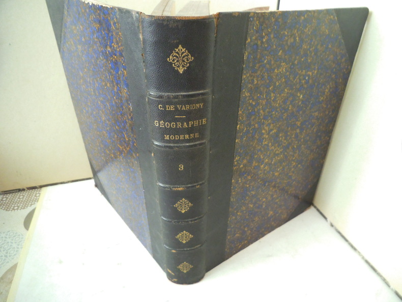
DE VARIGNY C.
ASIE
Nouvelle géographie moderne des cinq parties du monde. ASIE un volume in 4 demi-chagrin bleu à nerfs et à coins, titre, fers dorés. Faux-titre, frontispice, titre, 324 pages, tranches marbrées. Complet des 10 cartes, hors-texte, en couleurs ; Nombreuses gravures hors-texte, et en tête. Asie Mahométane (ouest) Asie Anglaise, Asie Russe, Asie bouddhiste (Est) Empire de Chine- Thibet-Mongolie-Turkestan chinois-Mongolie-Mandchourie-Corée-Empire du Japon-Indo-Chine (Annam, Tonkin, Cochinchine, Cambodge, Siam, Birmanie. Coins légèrement émoussés sinon bon exemplaire. Librairie illustrée 1890.
Referência livreiro : 12039
|
|
|
DE DION-BOUTON.
Carte Routière De Dion-Bouton. Rouen.
Puteaux, De Dion-Bouton, sd. Carte entoilée de 81x95 cm, enroulée sur deux tringles de bois noirci.
Referência livreiro : 6950
|
|
|
DE VAUGONDY Robert, Géographe Ordinaire du Roy - gravée par E. DUSSY
CARTE DE L'IRLANDE, par Robert de Vaugondy, tiré du "Nouvel atlas portatif destiné principalement pour l'instruction de la jeunesse, et précédé d'un discours sur l'étude de la géographie", par le S. Robert de Vaugondy, 1762 Paris : chez l'Auteur ( Robert de Vaugondy) Editeur,
Paris chez l'Auteur ( Robert de Vaugondy) Editeur, 1762 carte ancienne colorée d'époque en vert , rouge et jaune, cartouche non coloré, gravée par E. DUSSY. Format total : 27 centimètres de haut par 39,8 centimètres de large, 1762 Paris : chez l'Auteur (Robert de Vaugondy) Editeur,
Referência livreiro : 27383
|
|
|
DE VAUGONDY Robert, Géographe Ordinaire du Roy - gravée par E. DUSSY
CARTE DE LA LOMBARDIE, LE DUCHÉ DE TOSCANE, L'ÉTAT DU St SIÈGE ET L'ISLE DE CORSE, par Robert de Vaugondy, tiré du "Nouvel atlas portatif destiné principalement pour l'instruction de la jeunesse, et précédé d'un discours sur l'étude de la géographie", par le S. Robert de Vaugondy, 1762 Paris : chez l'Auteur ( Robert de Vaugondy) Editeur,
Paris chez l'Auteur ( Robert de Vaugondy) Editeur, 1762 carte ancienne colorée d'époque en vert , rouge et jaune, cartouche non coloré, gravée par E. DUSSY. Format total : 27 centimètres de haut par 39,8 centimètres de large, 1762 Paris : chez l'Auteur (Robert de Vaugondy) Editeur,
Referência livreiro : 27384
|
|
 Receber por correio electrónico
 Descarregar em documento PDF
 Fluxo RSS


