|
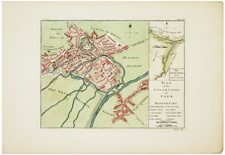
JEFFERYS (Thomas).
[CAEN] Plan of the city and castle of Caen.
[London, 1774]. 187 x 251 mm.
Riferimento per il libraio : LBW03d3d
|
|
|
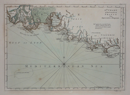
JEFFERYS (Thomas).
[PROVENCE] 15th chart of the coast of France from Aigues Mortes to Brégançon.
London, 1774. 180 x 248 mm.
Riferimento per il libraio : LBW03d44
|
|
|
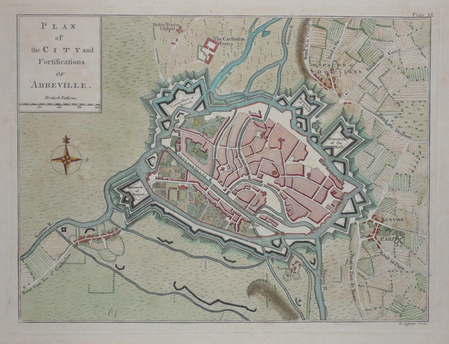
JEFFERYS (Thomas);
[ABBEVILLE] Plan of the city and fortifications of Abbeville.
London 1774 187 x 251 mm.
Riferimento per il libraio : LBW03d46
|
|
|
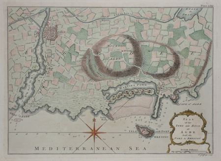
JEFFERYS (Thomas);
[AGDE] Plan of the town and mole of Agde with the fort de Brescou.
London 1774 197 x 276 mm.
Riferimento per il libraio : LBW03d43
|
|
|
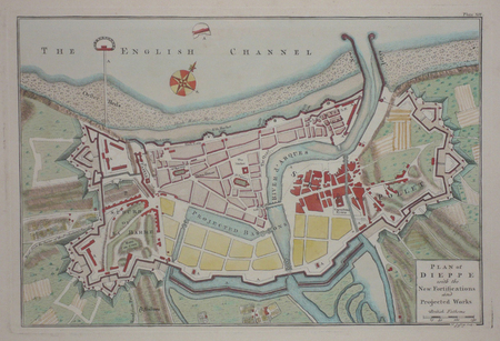
JEFFERYS (Thomas);
[DIEPPE] Plan of Dieppe with the new fortifications and projected works.
London 1774 209 x 312 mm.
Riferimento per il libraio : LBW03d47
|
|
|
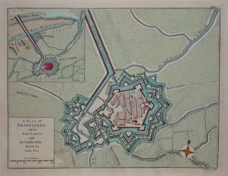
JEFFERYS (Thomas);
[GRAVELINES] A plan of Gravelines, with the new canal and the course of the river Aa to the sea.
London 1774 189 x 250 mm.
Riferimento per il libraio : LBW03d42
|
|
|
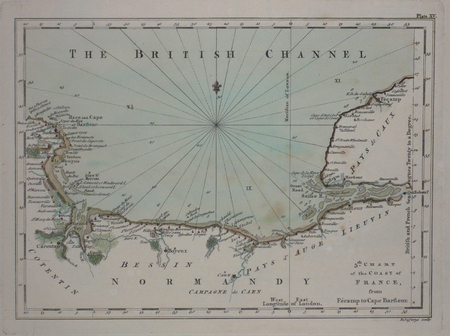
JEFFERYS (Thomas);
[NORMANDIE] 5th chart of the coast of France, from Fécamp to Cape Barfleur.
London 1774 180 x 248 mm.
Riferimento per il libraio : LBW03d48
|
|
|
Jefford, Andrew
Peat Smoke and Spirit : A Portrait of Islay and Its Whiskies
No marks or inscriptions. A very clean very tight copy with unmarked black cloth boards and no bumping to corners. Dust jacket not price clipped or marked or torn or creased with minor traces of storage. 406pp. History of the Scottish Isle of Islay and its whisky. The Island is home to seven of the world's most widely admired malt whisky distilleries on its shores and this study provides a most detailed analysis of Scotch malt whisky production. Maps on end papers.

|
|
|
Jenichen Balthasar (attivo dal 1560, morto nel 1599)
Roma
La rarissima veduta aerea di Roma di Balthasar Jenichen, pubblicata a Norimberga. La veduta di Jenichen deriva a sua volta da una xilografia della Cosmographia di Sebastian Münster (Basilea, 1550), che raffigura Roma così com'era intorno al 1490 (Per la veduta di Münster si veda A. Frutaz, Le piante di Roma, XCVIII)."Orientata con nord in basso. A proiezione obliqua; veduta prospettica. È una ripetizione del panorama comparso la prima volta col Bergomensis (1490) e, con lievi modificazioni, ripetuto poi nello Schedel, nel Munster e in altre edizioni tutte inspirate al panorama, detto di Mantova, e che rappresenta Roma sotto il Pontificato di Alessandro VI. Forse lo Jenicken ricalca un vecchio rame senza mai aver visto Roma, sicché non riesce ad interpretare la linea della cupola del Pantheon, colloca l'Aventino presso la Porta del Popolo e qua e là dissemina altri errori topografici. L'assenza del Colosseo ricollega la presente pianta più direttamente al Munster" (cfr. Scaccia Scarafoni, p. 74)."In alto a sinistra legenda con lettere di rimando in veduta (A-Z). È noto un solo altro esemplare con iscrizioni in caratteri gotici conservato al Paul Getty Museum ed un altro con iscrizioni in caratteri romani conservato presso la BVE. Si tratta pertanto di una pianta di estrema rarità e peraltro graficamente assai raffinata" (cfr. Marigliani p. 121, che erroneamente raffigura e attribuisce la copia con caratteri gotici allo Jenichen).Il lettering del nostro esemplare è in latino, mentre esiste una copia con caratteri gotici, di dimensioni ridotte. Un esempio (ex collezione Pecci-Blunt) si trova al Getty Museum, un altro è pubblicato su Marigliani, altro ancora è descritto da Scaccia Scarafoni alla Biblioteca Nazionale di Roma.La veduta dello Jenichen è sconosciuta a Frutaz, mentre Hollstein ne descrive solo 2 esemplari nelle collezioni dei gabinetti delle stampe di Berlino e Monaco. Scaccia Scarafoni descrive l'esemplare presso la Biblioteca Nazionale di Roma; Jenichen è stato il principale editore tedesco di carte topografiche. Insieme al connazionale Matthias Zündt si interessarono particolarmente alle cosiddette carte d'occasione - nate per documentare avvenimenti - e ne produssero diverse sulla scia e nella tradizione di quelle dei loro omologhi editori italiani. Data la loro natura effimera, sono tutte rare o introvabili.La veduta di Roma, priva di data, può essere ricondotta la periodo 1562-1590 in base alle informazioni sul periodo di attività dell'artista. Una datazione intorno al 1570 ci sembra più compatibile con alcuni dei lavori topografici - datati - dell'artista.Acquaforte e bulino, impressa su carta vergata coeva priva di filigrana, con margini, in perfetto stato di conservazione. Rarissima.BibliografiaScaccia Scarafoni, Le Piante di Roma, pp. 74-75, n. 129; Marigliani, Le piante di Roma nelle collezioni private, p. 121, n. 17; Hollstein XL B, p. 54, n. 150; G.K. Nagler, Lexicon, VI, p. 439, n. 2; Andresen II, Nr. 279; Passavant IV, p. 429, n. 27; Le Blanc, II, p. 429, n. 27. The very rare Balthasar Jenichen's etched bird's-eye view of Rome, published in Nuremberg. Jenichen's view in turn derived from a woodcut in Sebastian Münster's Cosmographia (Basel, 1550), which depicts Rome as it was about 1490 (For Münster's view, see A. Frutaz, Le piante di Roma, XCVIII).Münster's table with lettered names keyed to buildings and monuments on the view has been shifted from the foot to the upper left-hand corner in Jenichen and the present view. In its place at foot are eight quatrains of German verse on the rulers of Rome, the last line of which reads: Das spricht Balthasar Jenichen. Lettering in the present view is Latin, while there is a copy with Gothic lettering, reduced in size. One example (ex Pecci-Blunt collection's) is at the Getty Museum, another one is published in Marigliani - who erroneously attributes the copy with Gothic characters to Jenichen. Unknown by Frutaz; Hollstein describes only 2 example of this very rare work. Scaccia Scarafoni listed the further example at the Biblioteca Nazionale di Roma (that own also the copy with Gothic text).Jenichen was the leading German publisher of news-sheet maps. Jenichen and compatriot Matthias Zündt took particular interest in the conflict and produced views and maps of it that equaled and surpassed those of their Italian counterparts. Given their ephemeral nature, all are rare and desirable.The view of Rome, undated, can be traced back to the period 1562-1590 according to the artist's period of activity. A dating around 1570 seems to us to be more compatible with some of the artist's topographical and dated works.Etching and engraving, printed on contemporary laid paper, with margins, perfect condition.LiteratureScaccia Scarafoni, Le Piante di Roma, pp. 74-75, n. 129; Marigliani, Le piante di Roma nelle collezioni private, p. 121, n. 17; Hollstein XL B, p. 54, n. 150; G.K. Nagler, Lexicon, VI, p. 439, n. 2; Andresen II, Nr. 279; Passavant IV, p. 429, n. 27; Le Blanc, II, p. 429, n. 27.

|
|
|
Jenkins David/Sullivan Peter maps/graphics
Hitting Home: The Japanese Attack on Sydney 1942
Milsons Point: Random House Australia 1992. 1st printing. VG. 88 p. photos color/bw maps 4to paperback; Random House Australia paperback
Riferimento per il libraio : 70882 ISBN : 0091826683 9780091826680

|
|
|
JENKINS David maps and graphics by Peter SULLIVAN
HITTING HOME - The Japanese Attack on Sydney 1942
Milsons Point Random first edition - Trade paperback stiff card covers On the night of 31 May 1942 three Japanese submarines entered Sydney Harbour. The subsequent attack literally brought World War II to the doorstep of our biggest city. The shelling of Sydney and Newcastle together with attacks on merchant shipping along the east coast ensured Australia was 'at war'. 280 x 210mm. pp. viii 88 b/w plates & col. diagrams append. Trade paperback stiff card covers. Contents no inscriptions; card covers light rubbing on corners NO CREASES. VG ISBN: 0091826683 Milsons Point, Random paperback
Riferimento per il libraio : 160acb8748d3d4482d9ca036 ISBN : 0091826683 9780091826680

|
|
|
Jenkins Olaf P. text; Morgan Adrienne E. maps
The Great Watershed of California
Angel Press. Used - Good. Ships from Reno NV. Former Library book. Shows some signs of wear and may have some markings on the inside. 100% Money Back Guarantee. Shipped to over one million happy customers. Your purchase benefits world literacy! Angel Press unknown
Riferimento per il libraio : GRP110185654
|
|
|
Jenkins Olaf P. text; Morgan Adrienne E. maps
The Great Watershed of California: Map Trek Along the Unbroken Water Divide SIGNED
Monterey CA: Angel Press 1978. Book. Good. Paperback. Signed by Authors. 41 pages 4to. SIGNED by author Olaf P. Jenkins on title page. Shelfwear: scuffing along edges and covers some light tanning and foxing on covers heavy foxing on rear cover light tanning and foxing along page edges. Tightly bound no marks. Volume is in Good-plus condition. Angel Press Paperback
Riferimento per il libraio : 53567
|
|
|
Jenkinson Michael; illustrated with photographs by Karl Kernberger and maps
WILD RIVERS OF NORTH AMERICA
New York NY: E. P. Dutton & Company. G/G. 1973. First Edition. Cloth. Descriptions of some 115 wilderness waterways with indepth biographies of eight wild rivers and a voyagers' route. Seven appendices containing a select bibliography on river running; sources and information by states and provinces; conservation societies and whitewater organizations and boat builders and distributors. . 8vo. 413pp. Corner gently bumped rear hinge slightly shaken edge stains; dj frayed and torn . E. P. Dutton & Company hardcover
Riferimento per il libraio : BOOKS238999 ISBN : 0876900996 9780876900994

|
|
|
Jeremy Oats MBBS DM FRCOG FRANZCOG Suzanne Abraham MSc PhDMed MAPS
Llewellyn-Jones Fundamentals of Obstetrics and Gynaecology 9th Edition
Paperback. New. Brand New Softcover International Edition Have same content as US Edition. ISBN is different. Never Used in English Language. Printed in Black and White. 100% return and refund. paperback
Riferimento per il libraio : 1119888 ISBN : 072343509X 9780723435099

|
|
|
Jeremy Oats MBBS DM FRCOG FRANZCOG Suzanne Abraham MSc PhDMed MAPS
Llewellyn-Jones Fundamentals of Obstetrics and Gynaecology 9th Edition
New Item Softcover International Edition Have same content as US Edition. ISBN And Book cover may be different. Not a Used Book Book Language:English. Printed in Black and White. Excellent customer service response. paperback
Riferimento per il libraio : 195814 ISBN : 072343509X 9780723435099
|
|
|
Jeremy Oats MBBS DM FRCOG FRANZCOG; Suzanne Abraham MSc PhDMed MAPS
Llewellyn-Jones Fundamentals of Obstetrics and Gynaecology
Mosby 2010-04-06. Paperback. Good. Mosby paperback
Riferimento per il libraio : SONG072343509X ISBN : 072343509X 9780723435099
|
|
|
JERUSALEMS TEMPEL -
Jerusalems tempel Såsom thet syntes öster uth Medh alla sine Föreårdar eller Chorer, efter Ben. Ariae Montani Afritning.
(Stockholm, 1703). (33 x 42 cm.). Kobberstukket kort over Tempelgården i perspektiv. En ganske lille reparation nederste i midterfolden. I passpartou.
|
|
|
JERUSALEMS TEMPEL -
Jerusalems tempel Såsom thet syntes öster uth Medh alla sine Föreårdar eller Chorer, efter Ben. Ariae Montani Afritning.
(Stockholm, 1703). (33 x 42 cm.). Kobberstukket kort over Tempelgården i perspektiv. En ganske lille reparation nederste i midterfolden. I passpartou.
Riferimento per il libraio : 53195
|
|
|
JESSUP Frank W.
A History of Kent. with Maps and Pictures. BRIGHT, CLEAN COPY IN UNCLIPPED DUSTWRAPPER
8vo., First Edition, with 30 plates on 16 and 15 maps in the text; green cloth, gilt back, a very good, bright, clean copy in unclipped dustwrapper, the latter lightly frayed at extremities. Bennett p.184.

|
|
|
JEU DE BOSTON
Règles du jeu de Boston revues, corrigées et acceptées par toutes les Académies de Paris, avec les décisions des meilleurs joueurs sur les coups les plus difficiles
(Paris) Imprimerie d'Aubry s.d. in-12 de 11 pp. avec un simple titre de départ cart. moderne, rouss
Riferimento per il libraio : 1491
|
|
|
JEU DE CARTES
Déclaration du Roy, donnée à Versailles au mois de mars 1703, portant que le droit de dix-huit deniers, ordonné être établi sur chacun ieu de cartes ou tarots, sera réduit et modéré à douze deniers, à commencer au mois d'avril prochain
Grenoble Alexandre Giroud 1703 in-4 dérelié
Riferimento per il libraio : 36185
|
|
|
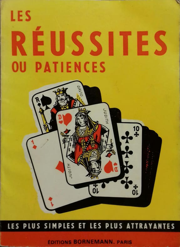
JEUX DE CARTES
Les réussites ou patiences.
Couverture souple. Broché. 48 pages.
Riferimento per il libraio : 140082
|
|
|
JEUX DE CARTES
Règle du je de Piquet - Piquet ordinaire - Piquet à écrire - Piquet normand - Piquet voleur - Lois et conventions.
Paris, Delarue, Paris, Delaruesd (v. 1890) ; in-12, broché, couverture jaune illustrée. 36 pp.Bel exemplaire.
Riferimento per il libraio : 35503465
|
|
|
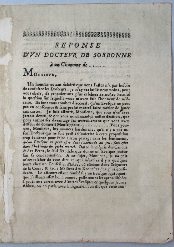
JEUX DE CARTES
Réponse d'un docteur de Sorbonnne à un chanoine de ...
(vers 1700).
Riferimento per il libraio : 18195
|
|
|
JH. Parry; Illustrator Half tone illus diagrams prints Charts maps. B/W J. H.
The Age of Reconnaissance: Discovery Exploration and Settlement 1450 to 1650 Praeger History of Civilization Series
Praeger Publishers 1969. Hardcover. Good/edges are bent and nicked. Plast. Hardcover with dust jacket in good minus condition. spine is heavily stained. front and back cover have some light soiling. front and back inside cover's inner edge's are ripped. Binding is weak. Pages clean. Praeger Publishers hardcover
Riferimento per il libraio : 043744
|
|
|
Jim Perry Blank Endpaper FORMER OWNER STAMP Illustrated By Photos Maps b/w
Stars Beyond The a Biographical Graveside Guide cemeteryS of Theda Bara Humphrey Bogart Bob Crane Marion Davies Sharon Tate Rudolph Valentino Peter Lorre Marilyn Monroe Bela Lugosi Errol Flynn Walt Disney Zazu Pitts Rosalind Russell ETC
Manhattan Beach CA Self-Published J. E. Perry 1978. Oblong Pictorial Paperback in B/W light creases Cover 1978 1st Edition Interior nice tight UNDERLINing Thruout VG/Good SOFTCOVER few notes in ink couple dog eared pgs . First Edition. Soft Cover. Manhattan Beach, CA Self-Published J. E. Perry paperback
Riferimento per il libraio : 23100
|
|
|
JMD. Pringle Maps By Marthe Rajchman J. M.
China Struggles for Unity
Penguin 1939. 2nd Printing. Very Good book in a Fair dustjacket. Scarce paperback in dustjacket. Penguin unknown
Riferimento per il libraio : 037805
|
|
|
Jo Sturges and Denise Laing (editors)
The Pub Guide 2004
No marks or inscriptions. No creasing to covers or to spine. A very clean very tight copy with bright unmarked boards, minor traces of storage to front cover and no bumping to corners. 704pp. The state of play with pubs which were open in 2004.

|
|
|
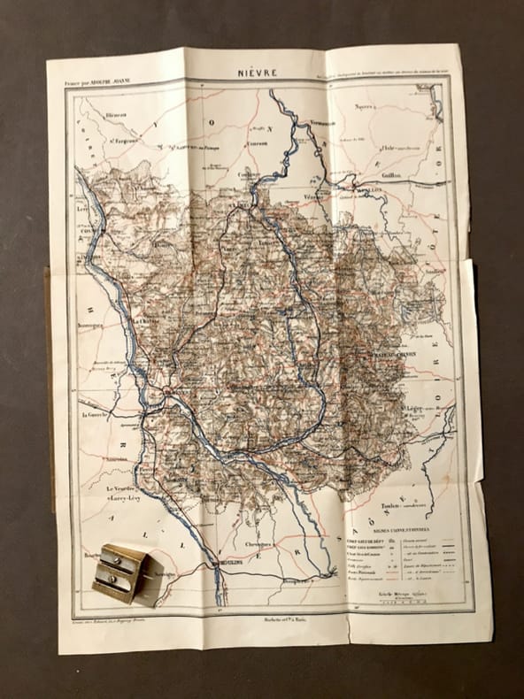
JOANNE (Adolphe)
Carte du département de la Nièvre.
Paris, Hachette, (circa 1900). 23,4 x 31,5 cm au cadre. Repliée sous une couverture petit in-12, toile beige de l'éditeur.
Riferimento per il libraio : 21810
|
|
|
JOANNE (Adolphe)
Géographie de l'Allier
Paris, Librairie Hachette, 1908, 66 pp. in-12, rel. carto. édit, dos toilé bleu, ill. h.t 24 grav. et une carte coloriée h.t dépl.
Riferimento per il libraio : 3807
|
|
|
JOANNE (Adolphe)
Géographie de l'Oise
Paris, Librairie Hachette, 1902, 60 pp. in-12, rel. carto. édit, dos toilé bleu, ill. h.t 13 grav. et une carte coloriée h.t dépl.
Riferimento per il libraio : 3804
|
|
|
JOANNE (Adolphe)
Géographie de La Somme
Paris, Librairie Hachette, 1903, 68 pp. in-12, rel. carto. édit, dos toilé bleu, ill. h.t 11 grav. et une carte coloriée h.t dépl.
Riferimento per il libraio : 3797
|
|
|
JOANNE (Adolphe)
Géographie des Hautes-Pyrénées
Paris, Librairie Hachette, 1897, 74 pp. in-12, rel. carto. édit, dos toilé bleu, ill. h.t 13 grav. et une carte coloriée h.t dépl.
Riferimento per il libraio : 3811
|
|
|
JOANNE (Adolphe)
Géographie du Cantal
Paris, Librairie Hachette, 1895, 68 pp. in-12, rel. carto. édit, dos toilé bleu, ill. h.t 16 grav. et une carte coloriée h.t dépl.
Riferimento per il libraio : 3814
|
|
|
JOANNE (Adolphe)
Géographie du département de l'Ariège
Paris, Librairie Hachette, 1896, 66pp. in-12, rel. carto. édit, dos toilé bleu, ill. h.t 12 grav. et une carte coloriée h.t dépl.
Riferimento per il libraio : 3794
|
|
|
JOANNE (Adolphe)
Géographie du Loiret
Paris, Librairie Hachette, 1903, 68 pp. in-12, rel. carto. édit, dos toilé bleu, ill. h.t 27 grav. et une carte coloriée h.t dépl.
Riferimento per il libraio : 3798
|
|
|
JOANNE (Adolphe)
Géographie du Lot
Paris, Librairie Hachette, 1879, 58 pp. in-12, rel. carto. édit, dos toilé bleu, ill. h.t 8 grav. et une carte coloriée h.t dépl.
Riferimento per il libraio : 3796
|
|
|
JOANNE (Adolphe)
Géographie du Maine-et-Loire
Paris, Librairie Hachette, 1908, 70 pp. in-12, rel. carto. édit, dos toilé bleu, ill. h.t 17 grav. et une carte coloriée h.t dépl.
Riferimento per il libraio : 3809
|
|
|
JOANNE (Adolphe)
Géographie du Nord
Paris, Librairie Hachette, 1904, 60 pp. in-12, rel. carto. édit, dos toilé bleu, ill. h.t 17 grav. et une carte coloriée h.t dépl.
Riferimento per il libraio : 3805
|
|
|
JOANNE (Adolphe)
Géographie du Puy-de-Dôme
Paris, Librairie Hachette, 1911, 82 pp. in-12, rel. carto. édit, dos toilé bleu, ill. h.t 21 grav. et une carte coloriée h.t dépl.
Riferimento per il libraio : 3813
|
|
|
JOANNE (Adolphe)
Géographie du Tarn-et-Garonne
Paris, Librairie Hachette, 1885, 60 pp. in-12, rel. carto. édit, dos toilé bleu, ill. h.t 8 grav. et une carte coloriée h.t dépl.
Riferimento per il libraio : 3802
|
|
|
JOANNE Ad.
Carte du d?partement de la Manche au 1/440 000?. Sans date.
1 feuille sous couverture toil?e d?fra?chie. 25x35 cm.
|
|
|
JOANNE Adolphe
FRANCE NORMANDIE
1886 cart. toil. éd. in-8, 7 cartes repliées / onglet et 4 plans, 580 p., 1886 hachete éd.,
Riferimento per il libraio : 717
|
|
|
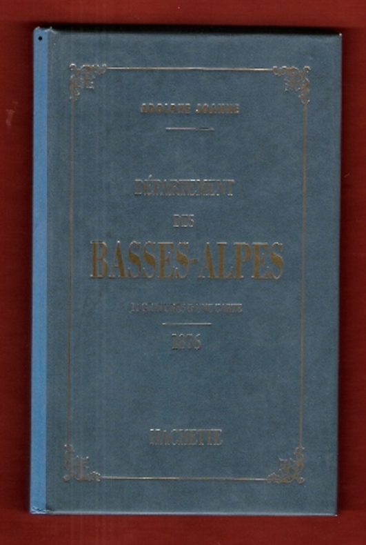
JOANNE Adolphe
Géographie Du Département Des Basses-Alpes . 11 Gravures & Une Carte Coloriée - 1876 . Complet De Sa Carte Dépliante En Couleurs
Très belle iconographie reprenant les gravures des villages de l'époque . Guide Joanne . Cartes et plans . - 50 p. , 300 gr.

|
|
|
JOANNE Adolphe
Géographie Du Département Des Basses-Alpes . 11 Gravures & Une Carte Coloriée - 1876 . Complet De Sa Carte Dépliante En Couleurs
Paris Hachette 1993 In 12 Très belle iconographie reprenant les gravures des villages de l'époque . Guide Joanne . Cartes et plans . - 50 p. , 300 gr.
Riferimento per il libraio : 009987
|
|
|
JOANNE Adolphe
Nouveau plan de Paris
- Hachette, Paris 1867, 11x17,8cm, relié. - Collection des guides Joanne. Liste alphabétique des rues de Paris avec également la liste des omnibus et leurs trajets, les prix, les voitures mobiles et autres transports publics. Reliure d'éditeur en pleine percaline violette. Dos lisse muet. Titre et armes de Paris sur le premier plat. Grand plan dépliante de Paris en couleurs. Plusieurs petites déchirures. Bon exemplaire. Le Paris de Napoléon III et de Haussman. Ce plan de Paris a été édité pour l'exposition universelle de Paris de 1867. On lit à la fin du capitre sur les voitures publiques : "Un service spécial, de la place du Palais-Royal au pot d'Iena, aura lieu pendant toute la durée de l'exposition". [ENGLISH DESCRIPTION ON DEMAND]

|
|
|
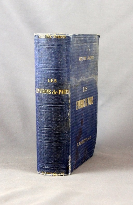
JOANNE Adolphe:
Les environs de Paris. Illustré. Itinéraire descriptif et historique.
Paris, Lib. de L. Hachette et Cie, [1856]. In-8 de XVI-847 pages, pleine percaline bleue d’éditeur, dos lisse orné de caissons à froid. Coiffes frottées, 1er plat taché, mors du 1er plat fendu en sa partie inférieure (3 cm), quelques rousseurs.
Riferimento per il libraio : 2432
|
|
|
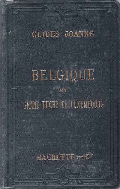
JOANNE Paul
Belgique et Grand-Duché De Luxembourg . Complet De Sa Carte Indépendante En Fin D'ouvrage
Paris Hachette & Cie 1894 In 16 Collection " Des Guides-Joanne " avec 15 plans et 7 cartes en couleurs dont certaines dépliantes . Nombreuses publicités , notamment d'hôtels mais aussi de Michelin , de chocolat Menier etc .- 312 p. + 118 p. , 550 gr.
Riferimento per il libraio : 015242
|
|
|
JOANNE Paul
Belgique et Grand-Duché De Luxembourg . Complet De Sa Carte Indépendante En Fin D'ouvrage
Collection " Des Guides-Joanne " avec 15 plans et 7 cartes en couleurs dont certaines dépliantes . Nombreuses publicités , notamment d'hôtels mais aussi de Michelin , de chocolat Menier etc .- 312 p. + 118 p. , 550 gr.

|
|
 Ricevere i risultati per e-mail
 Scaricare i risultati in PDF
 RSS feed


