|
MACKENZIE (Murdoch).
[ÉCOSSE/ÎLES ORCADES] Carte des îles Orcades et de la côte nord d'Écosse, depuis le cap Wrath jusqu'au cap Duncansby.
[Paris], Dépôt Général de la Marine, 1797. 619 x 897 mm.
Referencia librero : LBW-7571

|
|
|
MACON.
Carte géologique N° 148.
62 x 112 cm. carte toilée, coloriée. P. Dépôt de la Guerre 1848/1897,
Referencia librero : 9540
|
|
|
Machado Ana-Maria
L'Amérique latine
Bayard 1999 22 098x1 016x28 702cm. 1999. Broché.
Referencia librero : 500093548

|
|
|
MAC CARTHY J.
NOUVEAU DICTIONNAIRE GEOGRAPHIQUE UNIVERSEL
Chez l’auteur-Editeur, à la librairie nationale et étrangère, Paris, 1824
Referencia librero : 2398
|
|
|
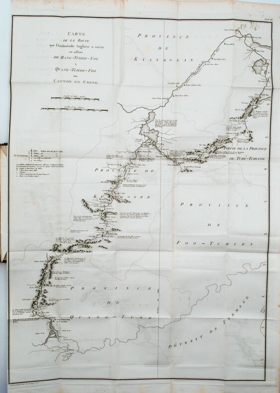
MACARTNEY , lord; CASTÉRA , J.(trad.)
Voyage dans l'intérieur de la Chine et en Tartarie, fait dans les années 1792, 1793 et 1794, par Lord Macartney, ambassadeur du roi d'Angleterre auprès du roi de la Chine.
Paris, F. Buisson, An 6 de la République (1798). Cinq volumes in-8 (21x13,5cm) , relié plein cuir époque , dos lisse orné avec pièces de titre et de tomaison , filet en torsade sur les plats, coins et coiffes usés , charnières frottées (fente sur le tome 1) , (4) viij, 515pp. et (4) 412pp. et (4) 399pp. et (4) 326pp. et (4) ij, 402pp. ; (2) , illustré de 29 gravures (32) , 4 frontispices et 3 grandes cartes dépliantes gravés par Tardieu l’Ainé , pages de titre brunis . Édition originale du voyage de Macartney avec le 5eme volume ,en seconde édition, contenant le précis de l’histoire de Chine par Huttner (1-184) et la relation de son voyage (187-358) dans une reliure uniforme .
Referencia librero : PHO-1110
|
|
|
MACARTNEY , lord; CASTÉRA , J.(trad.)
Voyage dans l'intérieur de la Chine et en Tartarie, fait dans les années 1792, 1793 et 1794, par Lord Macartney, ambassadeur du roi d'Angleterre auprès du roi de la Chine.
Paris, F. Buisson, An 6 de la République (1798). 4 volumes in-8 (21x13,5cm) , relié plein cuir tacheté époque , dos lisse orné avec pièces de titre et de tomaison , tranches marbrées, coins et coiffes usés avec manque, charnière faible au tome 4, (4) viij, 515pp. et (4) 412pp. et (4) 399pp. et (4) 326pp. et (4) ij, 402pp. ; (2) , illustré de 4 frontispices et 3 grandes cartes dépliantes (déchirures sans manques) gravés par Tardieu l’Ainé , mouillure sur quelques pages au tome 1.
Referencia librero : PHO-1309

|
|
|
MacDonald Charles B./Showalter Dennis new intro/McElfresh Earl maps
Company Commander
NY: History Book Club 2006. Book Club Edition BCE/BOMC. Fine/Fine dust jacket. xvi 309 p. photos 8vo with separate fold-out map ISBN 1885294328; History Book Club hardcover
Referencia librero : 66661 ISBN : 1582882509 9781582882505

|
|
|
Macfie, Matthew; Bonwick, James; Dyer, Jerome; Dicken, Charles Shortt; Cockburn, Sir John Alexander; Robinson, Sir William C.F.; Hall, G. Wilson; et al
Australasia - Volume IV (4 / Four) of The British Empire Series
xx, 364 pages. Two partially-coloured fold-out maps, of Australia and New Zealand, in excellent condition. Chapters include: Australia - General; New South Wales; Victoria; Queensland; South Australia; Western Australia; Australian Aboriginals; The Beginnings of an Australian Literature; Australian Fisheries; Tasmania; The Lost Tasmanian Race; New Zealand; The Maoris; Women of Australasia; British New Guinea; The Islands of the Western Pacific. Dark reddish cloth-covered boards adorned with gilt. Binding sound. Prior owner's name, dated 1911, inside front board. Moderate quanity of light pencil markings, primarily to latter half of book. Moderate wear. A sound copy. Book

|
|
|
Macgillivray William
The Conchologist's Text - Book Embracing the Arrangements of Lamarck and Linnaeus with a Glossary of Technical Terms to Wich is Added a Brief Account of the Mollusca
London: A. Fullarton and Co. 1853. 232 pages b/w engraved plates to the rear xxi. Original hardback binding near fine with minimal wear. Contents clean and tight plates complete and very clean and bright neat light inscription dated 1853 on the reverse of the front free endpaper no foxing. A near fine tight copy. Seventh Edition. Hardcover. Near Fine/No dust Jacket. Illus. by Abbey J. Sm 8vo. A. Fullarton and Co. Hardcover
Referencia librero : 022119

|
|
|
Mackay Douglas; maps by Macaulay R. H. H.
Honourable Company - History Of The Hudson't Bay Company
Tudor Publishing Co. 1938. Hardcover. Good. Disclaimer:A copy that has been read but remains in clean condition. All pages are intact and the cover is intact. The spine may show signs of wear. Pages can include limited notes and highlighting and the copy can include previous owner inscriptions. The dust jacket is missing. At ThriftBooks our motto is: Read More Spend Less. Tudor Publishing Co. hardcover
Referencia librero : GB001NCFHYSI3N01

|
|
|
Mackay Douglas Maps by RHH. Macaulay R. H.
The Honourable Company:A History of the Hudson's Bay Company
Indianapolis IN: Bobbs-Merrill Co. 1936. First Edition. Hardcover. Good. Size is 8vo. 48 Illustrations Maps. full book description Bobbs-Merrill Co. Indianapolis IN 1936. 1st Edition 1st Printing Good Hard Cover No Dust Jacket. Size is 8vo 396pgsINDEX. 48 Illustrations Maps. Shelfwear on spine & ink owner name/address on back of frontispiece o.w. a clean copy. SELLING WORLDWIDE SINCE 1987. WE ALWAYS PACK WITH GREAT CARE! First Printing Bobbs-Merrill Co. hardcover
Referencia librero : CONROY033906I
|
|
|
Mackey Sandra 1937 ; maps G. W. Ward ; design Robert Anthony ; photo Anthony Edgeworth
The Saudis : inside the desert kingdom. The oil boom 1974-1980 -- The coming of a foreigner -- The Magic Kingdom -- Managing the boom -- Servants of God -- Living with Islam -- Bedouin pride -- The shackles of sex -- Mysteries of the hareem -- Putting Saudis to work -- The royal tribe -- There was no tomorrow -- The twilight 1980 and beyond -- The press : Pride and denial -- Jail : a clear and present danger -- Swords and missiles : the search for security -- The world creeps closer -- The new realities -- Castles of sand -- Stalled between seasons
New York : Meridian 1988 1987 1988. Book. Fine. Hardcover. 1st edition 1st printing ; x 433 p. : maps ; 20 cm. ; SBN: 0395411653; 9780395411650 LCCN: 86-27663 ; Dewey: 953/.8 ; OCLC: 15018174 ; sand-colored cloth with color photographic dustjacket ; Contents: The oil boom 1974-1980 -- The coming of a foreigner -- The Magic Kingdom -- Managing the boom -- Servants of God -- Living with Islam -- Bedouin pride -- The shackles of sex -- Mysteries of the hareem -- Putting Saudis to work -- The royal tribe -- There was no tomorrow -- The twilight 1980 and beyond -- The press : Pride and denial -- Jail : a clear and present danger -- Swords and missiles : the search for security -- The world creeps closer -- The new realities -- Castles of sand -- Stalled between seasons ; remains of label on front ep tiny mark on textblock else FINE/FINE. [New York] : Meridian, 1988, 1987 Hardcover
Referencia librero : 006344 ISBN : 0395411653 9780395411650

|
|
|
Mackinder Halford John; illustrated in colour after Mrs. James Jardine; two maps
The Rhine
Dodd Mead and Company NY 1908. Hardcover. Very Good /No Jacket. "Having gathered waters from its tributaries as it were the roots and rootlets penetrating the ground and drawing sap into the trunk it parts into distributaries which traverse the delta like tree branches which carry the moisture back into the air. The delta of the Rhine begins to-day just within the border of Holland although two hundred years ago the division took place in Germany. From the time when Virgil described the Rhine as 'two-horned' the prime division has undoubtedly been into two main distributaries but apart from this fact everything has changed during the intervening centuries." Exerpt from book Owner address label; decorative cover; general wear to extremities top and bottom of spine and corners. Dodd, Mead and Company NY hardcover
Referencia librero : 1410NAL

|
|
|
Macnab, P. A.
Strathpeffer Spa
No marks or inscriptions. No creasing to covers, both of which are slightly curled outwards. A very clean very tight copy with bright unmarked boards, tiny rub to upper front edge and no bumping to corners. 68pp. A detailed guide to the health benefits of the local Spa water at Strathpeffer in Ross and Cromarty plus a series of motor tours around the area, its history and some Scottish to English translations of place names. Illustrated. Undated ca 1960.
|
|
|
MACON
Carte allemande en couleurs au 1/200 000?.
Une feuille 55 x 75 cm repli?e.
|
|
|
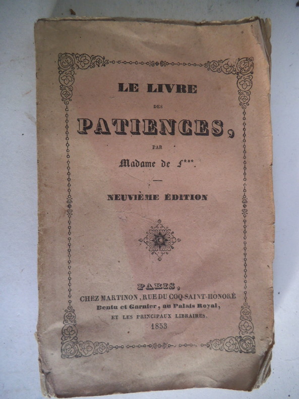
Madame de F…
Le livre des patiences.
In 16 broché, faux-titre, titre, 106 pages, Paris chez Martinon 1852. (Ccouverture datée 1853) La loi salique-le moulin-les quatorze- la brocarde-la carte voyageuse- le sultan- la duchesse de Luynes- etc.
Referencia librero : 12402
|
|
|
MADAME De F
Le Livre Des Patiences
Paris Dentu & Garnier 1894 In12 Exemplaire a restaurer ou relier - 108 pages - manques important sur le 1er plat - dos cassé
Referencia librero : 25Et
|
|
|
MADAME De F
Le Livre Des Patiences
Paris Dentu & Garnier 1894 In12 Exemplaire a restaurer ou relier - 108 pages - manques important sur le 1er plat - dos cassé
Referencia librero : 25Et
|
|
|
MAD Maps
Adventure America
MAD Maps 2006-09-01. Map. Used:Good. MAD Maps unknown
Referencia librero : SONG0967473799 ISBN : 0967473799 9780967473796

|
|
|
MAD Maps
Get Outta Town: Phoenix Laminated Map
MAD Maps 2006-11-01. Map. Good. MAD Maps unknown
Referencia librero : SONG1933911166 ISBN : 1933911166 9781933911168
|
|
|
MAD Maps
Get Outta Town: Columbus Laminated Map
MAD Maps 2007-02-01. Map. Good. MAD Maps unknown
Referencia librero : SONG193391128X ISBN : 193391128X 9781933911281

|
|
|
MAD Maps
Get Outta Town: Atlanta Laminated Map
MAD Maps 2006-09-01. Map. Good. MAD Maps unknown
Referencia librero : SONG1933911123 ISBN : 1933911123 9781933911120

|
|
|
MAD Maps
Get Outta Town: Boston Laminated Map
MAD Maps 2007-02-01. Map. Good. MAD Maps unknown
Referencia librero : SONG1933911271 ISBN : 1933911271 9781933911274

|
|
|
MAD Maps
Get Outta Town: Detroit Laminated Map
MAD Maps 2007-02-01. Map. Good. MAD Maps unknown
Referencia librero : SONG1933911255 ISBN : 1933911255 9781933911250

|
|
|
MAD Maps
Get Outta Town: Miami Laminated Map
MAD Maps 2007-02-01. Map. Good. MAD Maps unknown
Referencia librero : SONG1933911298 ISBN : 1933911298 9781933911298

|
|
|
MAD Maps
Get Outta Town: New York Laminated Map
MAD Maps 2006-09-01. Map. Good. MAD Maps unknown
Referencia librero : SONG1933911034 ISBN : 1933911034 9781933911038

|
|
|
MAD Maps
Get Outta Town: San Jose Laminated Map
MAD Maps 2006-11-01. Map. Good. MAD Maps unknown
Referencia librero : SONG1933911174 ISBN : 1933911174 9781933911175

|
|
|
MAD Maps
Get Outta Town: Washington DC Laminated Map
MAD Maps 2006-09-01. Map. Good. MAD Maps unknown
Referencia librero : SONG1933911026 ISBN : 1933911026 9781933911021

|
|
|
MAD Maps
Get Outta Town: Baltimore Laminated Map
MAD Maps 2007-02-01. Map. Good. MAD Maps unknown
Referencia librero : SONG1933911247 ISBN : 1933911247 9781933911243

|
|
|
MAD Maps
Get Outta Town: Fort Worth/Dallas Laminated Map
MAD Maps 2006-09-01. Map. Good. MAD Maps unknown
Referencia librero : SONG1933911050 ISBN : 1933911050 9781933911052

|
|
|
MAD Maps
Get Outta Town: San Antonio Laminated Map
MAD Maps 2006-11-01. Map. Good. MAD Maps unknown
Referencia librero : SONG1933911204 ISBN : 1933911204 9781933911205

|
|
|
MAD Maps
Get Outta Town: Denver Laminated Map
MAD Maps 2006-09-01. Map. Good. MAD Maps unknown
Referencia librero : SONG1933911018 ISBN : 1933911018 9781933911014

|
|
|
MAD Maps
Get Outta Town: Las Vegas Laminated Map
MAD Maps 2006-11-01. Map. Good. MAD Maps unknown
Referencia librero : SONG1933911131 ISBN : 1933911131 9781933911137

|
|
|
MAD Maps
Get Outta Town: Portland Laminated Map
MAD Maps 2006-11-01. Map. Good. MAD Maps unknown
Referencia librero : SONG1933911212 ISBN : 1933911212 9781933911212

|
|
|
MAD Maps
Get Outta Town: Memphis Laminated Map
MAD Maps 2007-02-01. Map. Good. MAD Maps unknown
Referencia librero : SONG1933911301 ISBN : 1933911301 9781933911304

|
|
|
MAD Maps
Get Outta Town: Milwaukee Laminated Map
MAD Maps 2007-02-01. Map. Good. MAD Maps unknown
Referencia librero : SONG1933911239 ISBN : 1933911239 9781933911236
|
|
|
MAD Maps
Get Outta Town: Houston Laminated Map
MAD Maps 2006-09-01. Map. Good. MAD Maps unknown
Referencia librero : SONG1933911042 ISBN : 1933911042 9781933911045

|
|
|
MAD Maps
Get Outta Town: Chicago Laminated Map
MAD Maps 2007-02-01. Map. Good. MAD Maps unknown
Referencia librero : SONG1933911263 ISBN : 1933911263 9781933911267
|
|
|
MAD Maps
Get Outta Town: Seattle Laminated Map
MAD Maps 2006-08-01. Map. Good. MAD Maps unknown
Referencia librero : SONG193391100X ISBN : 193391100X 9781933911007

|
|
|
MAD Maps
Get Outta Town: Austin Laminated Map
MAD Maps 2006-11-01. Map. Good. MAD Maps unknown
Referencia librero : SONG1933911190 ISBN : 1933911190 9781933911199

|
|
|
MAD Maps
Get Outta Town Series: San Diego CA
MAD Maps 2006-11-01. Map. Good. MAD Maps unknown
Referencia librero : SONG1933911115 ISBN : 1933911115 9781933911113
|
|
|
MAD Maps
Get Outta Town: San Francisco Laminated Map
MAD Maps 2006-11-01. Map. Good. MAD Maps unknown
Referencia librero : SONG1933911182 ISBN : 1933911182 9781933911182

|
|
|
MAD Maps
Get Outta Town: Philadelphia Laminated Map
MAD Maps 2006-02-01. Map. Good. MAD Maps unknown
Referencia librero : SONG1933911220 ISBN : 1933911220 9781933911229

|
|
|
MAD Maps
Get Outta Town: Los Angeles Laminated Map
MAD Maps 2006-11-01. Map. Good. MAD Maps unknown
Referencia librero : SONG1933911158 ISBN : 1933911158 9781933911151

|
|
|
Mad Maps
Harley Davidons Great Roads Pacific Coast Map Harley Davidson Road Songs
Mad Maps 2007-05-15. Map. Good. Mad Maps unknown
Referencia librero : SONG1933911565 ISBN : 1933911565 9781933911564
|
|
|
MAD Maps
MAD Maps - Get Outta Town Scenic Road Trips Map - Seattle - GOTSEA1
2007-06-06. New. Ships with Tracking Number! INTERNATIONAL WORLDWIDE Shipping available. May be re-issue. Buy with confidence excellent customer service! unknown
Referencia librero : 193391100Xn ISBN : 193391100x 9781933911007
|
|
|
MAD Maps
MAD Maps - Rally Run Road Trip Map - Myrtle Beach - RRMB01
2006-01-01. New. Ships with Tracking Number! INTERNATIONAL WORLDWIDE Shipping available. May be re-issue. Buy with confidence excellent customer service! unknown
Referencia librero : 1933911077n ISBN : 1933911077 9781933911076

|
|
|
MAD Maps
MAD Maps - Scenic Road Trips Map of Virginia - East West Virginia - Maryland - Delaware - USRT190
2013-07-01. New. Ships with Tracking Number! INTERNATIONAL WORLDWIDE Shipping available. May be re-issue. Buy with confidence excellent customer service! unknown
Referencia librero : 193391193Xn ISBN : 193391193x 9781933911939

|
|
|
MAD Maps
MAD Maps - Scenic Road Trips Map of Virginia - East West Virginia - Maryland - Delaware - USRT190
2013-07-01. Good. Ships with Tracking Number! INTERNATIONAL WORLDWIDE Shipping available. May not contain Access Codes or Supplements. May be re-issue. May be ex-library. Shipping & Handling by region. Buy with confidence excellent customer service! unknown
Referencia librero : 193391193X ISBN : 193391193x 9781933911939

|
|
|
Mad Maps
New York Regional Scenic Tours
Mad Maps 2008-01-01. Map. Good. Mad Maps unknown
Referencia librero : SONG1933911948 ISBN : 1933911948 9781933911946
|
|
 Recibir por correo electrónico
 Descargar en documento PDF
 Flujo RSS


