|
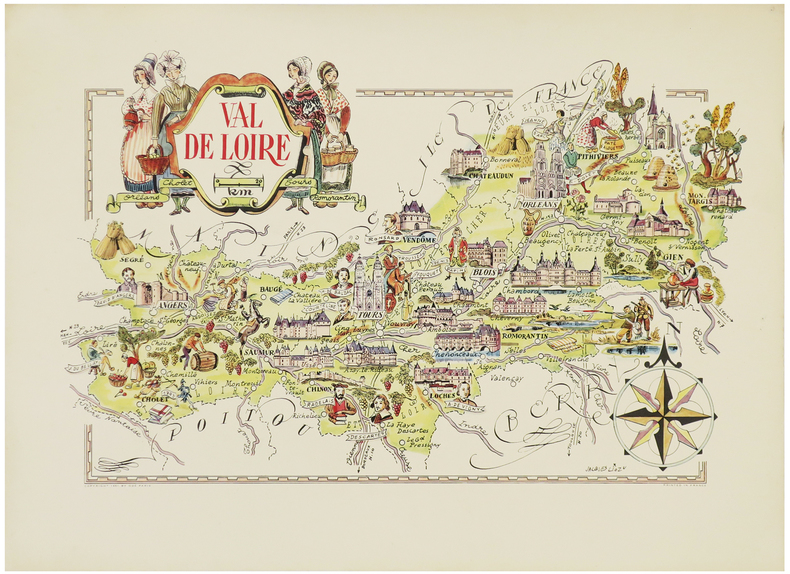
LIOZU (Jacques).
[Val de LOIRE] Val de Loire.
Paris, Odé, 1951. 310 x 490 mm.
书商的参考编号 : LBW-6305
|
|
|
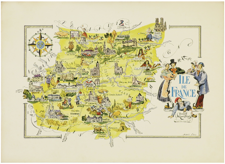
LIOZU (Jacques).
[ÎLE-de-FRANCE] Île de France.
Paris, Odé, 1951. 330 x 484 mm.
书商的参考编号 : LBW-6302
|
|
|
LIOZU (Jacques).
Amérique du Sud.
Paris, Odé, 1951. 485 x 390 mm.
书商的参考编号 : LBW-7562

|
|
|
LIOZU (Jacques).
Europe centrale & orientale.
Paris, Odé, 1951. 488 x 356 mm.
书商的参考编号 : LBW-7561

|
|
|
Littérature Policière - Rivages / Noir
Série complète 12 cartes postales publicitaires pour la collection Rivages/Noir ( Neuf, scellé ).
Editions Rivages sans date. Magnifique série complète de 12 cartes postales publicitaires pour la collection Rivages/Noir au format 10 x 15 cm. Reproductions de couvertures de roman de James Ellroy, James Lee Burke, Sean Doolittle, Robert Bloch, Tony Hillerman, Bill James, Louis Sanders, David Goodis, Donald Westlake, Paco Ignacio Taibo II, Barouk Salamé & David Peace. Edition originale hors commerce. Etat de neuf sous blister.
书商的参考编号 : 22029

|
|
|
Livingston, Helen
Hampshire, The New Forest and The Isle of Wight
No marks or inscriptions. No creasing to covers or to spine. A lovely clean very tight copy with bright unmarked boards and no bumping to corners. 128pp.

|
|
|
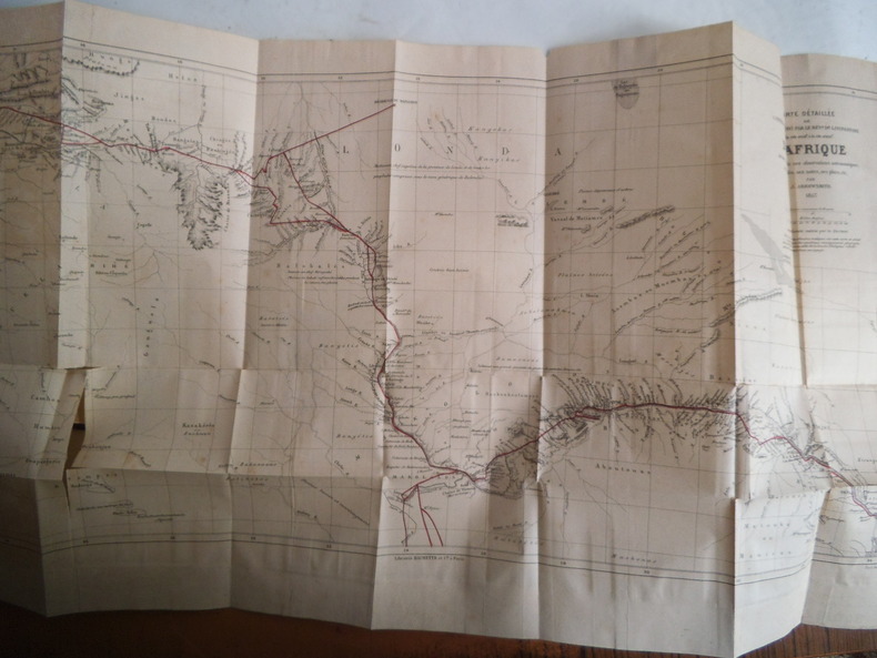
LIVINGSTONE David
Explorations dans l’intérieur de l’Afrique Australe et voyage à travers le continent de Saint-Paul de Loanda à l’embouchure du Zambèze de 1840 à 1856.
Ouvrage traduit de l’anglais avec l’autorisation de l’auteur par Mme H.LOREAU.In 8 demi-chagrin rouge époque titre,fer,roulette filet dorés, filets à froid.Faux-titre, grande vue dépliante(chute du Zambèze)en frontispice, titre,1 page,1 portrait de l’auteur,688 pages,un appendice de 4 pages:situation des lieux visités par le docteur LIVINGSTONE.Nombreuses gravures Hors-texte, une coupe idéale du centre de l’Afrique Australe(dépliante.Une grande carte dépliante,détaillée de l’itinéraire suivi par le Dr LIVINGSTONE.Une carte dépliante de l’Afrique Australe indiquant les voyages du révérend docteur LIVINGSTONE. Hachette & Cie 1877.Très bon état,pratiquement sans rousseurs.
书商的参考编号 : 5665
|
|
|
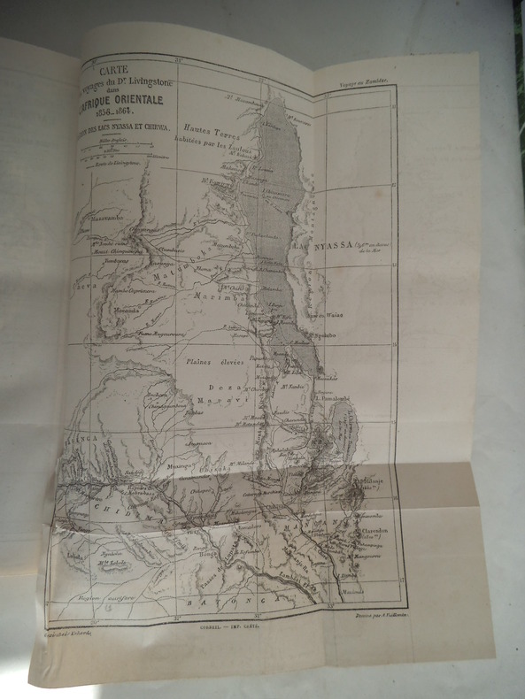
LIVINGSTONE David et Charles
Explorations du Zambèze et des ses affluents et découverte des Lacs CHIROUA et HYASSA 1858-1864
ouvrage traduit de l’anglais avec l’autorisation des auteurs par Mme H.LOREAU in 8 demi-chagrin rouge époque, titre,roulette,filets dorés,filets à froid.Faux-titre, titre IV 588 pages,47 gravures hors-texte,complet des quatre cartes dépliantes en fin de volume.Hachette & Cie 1881.Rousseurs éparses,sinon Très bon état 262 LIVINGSTONE David révérend docteur Explorations dans l’intérieur de l’Afrique Australe et voyage à travers le continent de Saint-Paul de Loanda à l’embouchure du Zambèze de 1840 à 1856. Ouvrage traduit de l’anglais avec l’autorisation de l’auteur par Mme H. LOREAU. In 8 demi -chagrin rouge époque titre, fer, roulette filet dorés, filets à froid. Faux-titre, grande vue dépliante (chute du Zambèze) en frontispice, titre, 1 page, 1 portrait de l’auteur, 688 pages, un appendice de 4 pages : situation des lieux visités par le docteur LIVINGSTONE. Nombreuses gravures Hors-texte, une coupe idéale du centre de l’Afrique Australe (dépliante). Une grande carte dépliante, détaillée de l’itinéraire suivi par le Dr LIVINGSTONE. Une carte dépliante de l’Afrique Australe indiquant les voyages du révérend docteur LIVINGSTONE. Hachette & Cie 1877. Très bon état, pratiquement sans rousseurs. 250€
书商的参考编号 : 5664
|
|
|
LIVINGSTONE David et Charles:
Explorations du Zambèse et de ses affluents et découverte des lacs Chiroua et Nyassa en 1858 - 1864. Traduit de l'anglais avec l'autorisation de l'auteur par Mme H. Loreau.
Paris, Librairie de L. Hachette et Cie, 1866. In-8 de [8]-580 pages, demi-percaline verteà coins, à la Bradel, étiquette de titre en maroquin brun, non rogné, couvertures et dos conservés.
书商的参考编号 : 20538
|
|
|
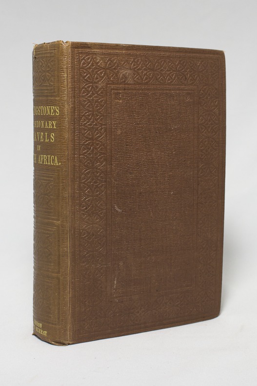
LIVINGSTONE David:
Missionary Travels and Researches in South Africa; including a Sketch of Sixteen Years' Residence in the Interior of Africa, and a Journey from the Cape of Good Hope to Loanda on the West Coast; thence across the Continent, down the River Zambezi, to the Eastern Ocean.
London, John Murray, 1857. Petit in-4 de IX-[1]-687-8 pages, pleine percaline brune décorée à froid. Etiquette de la librairie Desrogis, à Genève (de l'époque de la publication de l'ouvrage). Infime fente à la coiffe supérieure. Etiquette du relieur: Edmonds & Remnants.
书商的参考编号 : 14921
|
|
|
Livingstone, W. (editor)
The Sunny South Holiday Guide 1965
No marks or inscriptions. No creasing to covers, creases to spine. A very clean crisp very tight copy with bright unmarked very slightly sunned boards and no bumping to corners. 696pp. Very detailed work covering almost 90 resorts across the south of England. How to 'holiday' in 1965.

|
|
|
LIÉBAUX (Henri).
Plan de la forêt de Halatte où sont les nouvelles routes faites par ordre du roy. Avec les environs de Senlis.
Paris, chez l'auteur, [1720]. 418 x 612 mm.
书商的参考编号 : LBW-3819

|
|
|
Ljapidus, L. V. Petrenko, J. F. ; Glav. upravlenije geodezii i kartografii pri Sovete ministrov SSSR.
Politiko-Administrativnaja karta CCCP
1 multi-fold, multi-color map housed in stiff pink printed wraps/ Scale: 1: 8,000,000 mapa : 134 x 202 cm. In Russian. Finely detailed map of the former Union of Soviet Socialist Republics (USSR). Very large ( approx 2 x 4.5 feet)
|
|
|
LLOPIS LLADO Noël
Pirineo catalan : La Ribagorça, ruta de la vall d'Aran-Mulleres-Besiberri-Gelada-Salenques-LLauset-Fenarroi-Senet-Aneto-Bono.
Editorial Alpina, Granollers, 1972. In-12 broché, 24 pages de texte et descriptions, une grande carte dépliante en couleurs, texte en espagnol (mapa 1:25 000 y guia cartografica). Très bon état. // In-12 briscado, 24 páginas de texto y descripciones, una gran tarjeta(mapa) desplegable en colores (mapa 1:25 000 guia cartografica), Texto en español. Estado muy bueno.
书商的参考编号 : 16910
|
|
|
LLOPIS LLADÓ, N. - COLL, Xavier
SERRA DEL CADÍ - Granollers 1958 - Mapa
Granollers, Editorial Alpina, 1958. Pedraforca - Serra Pedregosa - Tancalaporta - Cadinell - Costa Freda. Mapa topográfico y notas explicativas. Escala 1:25.000. Mapa entelado y plegado. Buen ejemplar.
|
|
|
LLOPIS, N.
MOIXARÓ - Granollers 1958 - Mapa
Granollers, Editorial Alpina, 1958. Mapa topográfico excursionista. Escala 1:25.000. Mapa entelado y plegado. Buen ejemplar. Tossa d Alp - La Moixa - El Pendís - Coll de la Bauma - Gisclareny
|
|
|
LLOPIS, R.
ANDORRA III. BAIX VALIRA - Granollers s/f- Mapa
Granollers, Editorial Alpina, s/f. Mapa topográfico excursionista. Escala 1:25.000. Mapa entelado y plegado. Muy buen ejemplar.
|
|
|
Lloyd Lewis & Engravings & Maps Photos
Sherman Fighting Prophet
Harcourt Brace & Co. NY. Good with no dust jacket. 1958. Hardcover. 015181905X . C- Moderate wear to red cloth covers. Age toning on end pages and closed edges. Binding sound. Text clean of highlighting underlining or other pen/pencil marks. Due to size and/or weight of the book I can only ship it domestic mail. A Little Store that's BIG on Service. Tracking on every package. ; 9.50 X 6.30 X 1.80 inches; 690 pages . Harcourt Brace & Co., NY hardcover
书商的参考编号 : 29010 ???????? : 015181905X 9780151819058

|
|
|
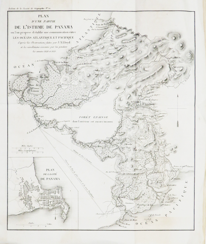
LLOYD (John Augustus).
[CANAL de PANAMA] Plan d'une partie de l'isthme de Panama où l'on propose d'établir une communication entre les océans Atlantique et Pacifique.
[1830]. 287 x 201 mm.
书商的参考编号 : LBW-4815
|
|
|
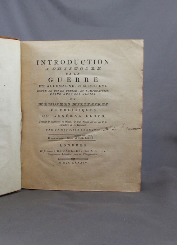
LLOYD Général Henry, Humphrey, Evans:
Introduction à l’histoire de la guerre en Allemagne, en M. DCC. LVI. entre le Roi de Prusse, et l’Impératrice-Reine avec ses alliés. Ou Mémoires militaires et politiques du général Lloyd.
Londres, Chez A.F. Pion, 1784. In-4 de LXXII-218-[2]-V pages, plein veau marron, dos à nerfs orné. Dos frotté, mors fendus, coiffes manquantes, plats frottés avec manque au 2nd plat.
书商的参考编号 : 1652
|
|
|
Lloyd, Nancy
Observing Our Peninsula's Past: The Age of Legends Through 1931, Volume One of the Chinook Observer Centennial Project
A clean, unmarked book with a tight binding. 10 3/4"w x 8 3/8"h. 168 pages. Many b&w illustrations and photographs.

|
|
|
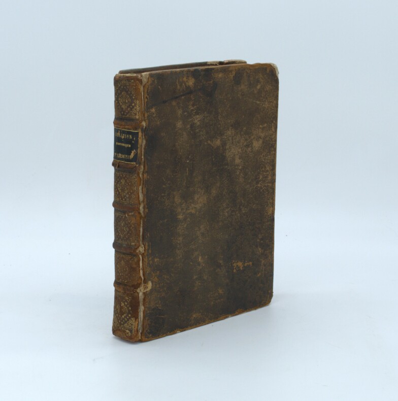
LOBO ,(Père Geronimo) ,LEGRAND (Abbé Joachim , Trad.)
Relation historique d'Abissinie.
Paris, veuve Coustelier, 1728, In-4, XIV-2ff.-514pp.-4ff.(table), illustré d’un frontispice et de 2 cartes dépliantes , relié plein cuir époque , dos à nerfs avec pièce de titre ,cachet, reliure frottée , charnières fendues, coins et coiffes usés .
书商的参考编号 : PHO-1369
|
|
|
Lobsenz, Norman M.
West Germany
8vo, 88 pages, illustrated with photographs. Ex public library copy. Tape marks to the endpapers. eng
|
|
|
LOCHES
Carte au 1/80 000?.
Une feuille 87x60 cm. Dos toil?. Rousseurs.
|
|
|
LOCHES...
Carte au 1/80 000e. Loches (S-O).
Une feuille 42x62 cm. D?fra?chie. Annot?e au crayon.
|
|
|
LOCHOM Michel van (1601-1647)
Romanum Imperium Ex Abrahami Ortelii
Rara carta geografica dell'Impero Romano incisa da Henry le Roy per Michael van Lochom. Si basa, come enunciato nel titolo sulla carta che Abraham Ortelius realizza per il sul atlante storico, il Parergon. Michel van Lochom (Anversa, 1601 - Parigi, 1647) è un incisore ed editore fiammingo. Michel van Lochom nacque il 28 aprile 1601 ad Anversa, dove fu battezzato il 5 maggio. È il figlio di Hans van Lochom, anche lui incisore, e di Clara Janssens. Divenne membro della Gilda di San Luca di Anversa nel 1613, dove fu allievo di Abraham van Merlen. Divenne libero maestro della corporazione nel 1621. Si trasferì a Parigi nel 1625, dove fu attivo come incisore ed editore di stampe fino al 1647. Sposò Marguerite Lenoir, figlia di un libraio, il 12 novembre 1625, dopo aver rinunciato alla sua fede protestante. Ha inciso principalmente scene religiose e ritratti. Lochom divenne anche l'incisore del re per la calcografia. Morì a Parigi il 23 gennaio 1647. Sebbene priva di data la carta può essere ricondotta al periodi 1640-47. Acquaforte, stampata su carta vergata coeva, irregolarmente rifilata al rame con parziale o totale perdita della cornice ornamentale, in ottimo stato di conservazione. Molto rara. Rare map of the Roman Empire engraved by Henry le Roy for Michael van Lochom. It is based, as stated in the title on the map that Abraham Ortelius made for his historical atlas, the Parergon. Michel van Lochom (Antwerp, 1601 - Paris, 1647) is a Flemish engraver and publisher. Michel van Lochom was born on April 28, 1601 in Antwerp, where he was baptized on May 5. He is the son of Hans van Lochom, also an engraver, and Clara Janssens. He became a member of the guild of Saint Luke of Antwerp in 1613, where he was a pupil of Abraham van Merlen. He became freemaster of the guild in 1621. He moved to Paris in 1625, where he was active as an engraver and print editor until 1647. He married Marguerite Lenoir, daughter of a bookseller, on November 12, 1625, after renouncing his Protestant faith. He mainly engraved religious scenes1 and portraits4. Lochom became the king's engraver for the engravings. Michel van Lochom died in Paris on January 23, 1647. Although undated the map can be traced to the 1640-47 period. Etching, printed on coeval laid paper, irregularly trimmed to copper with partial or total loss of the ornamental frame, in excellent condition. Very rare.

|
|
|
Lockley, R. M.
Britain in Colour
No marks or inscriptions. A lovely clean very tight copy with bright unmarked boards and no bumping to corners. Price clipped dust jacket not marked or torn with light creasing/rubbing to edges. 143pp. The British Isles as it looked forty years ago.

|
|
|
LODDÈRE (J. de).
Le riz d'Indochine.
[Paris], Havas, [1932]. 393 x 595 mm marges comprises.
书商的参考编号 : LBW-8575

|
|
|
Lodge, Eric (compiled by)
Yorkshire Dales Official Guide & Map
No marks or inscriptions. Small crease to upper corner of front cover. A very clean very tight copy with slightly dusty covers and page edges and no bumping to corners. Large fold out map at rear in excellent condition. 118pp. Detailed description dale by dale,-village by village, site of interest by site of interest through all the Yorkshire Dales. Undated ca 1960.

|
|
|
Lodge, Eric (editor)
Holidays in Yorkshire : The White Rose Shire
No marks or inscriptions to contents. Slight creasing to covers. Clean pages in a tight binding with very slightly marked slightly rubbed boards, and no bumping to corners. Covers secured to book with brown paper tape. 128pp. Very scarce.

|
|
|
Lofthouse, Jessica
Countrygoers' North
No marks or inscriptions. A very clean very tight copy with bright unmarked boards, bump to top of spine and n bumping to corners. Dust jacket not price clipped or marked or torn with creasing to spine ends and slight sunning to rear. 240pp. The well-known Lancashire travel writer concentrates here on the lesser known parts of north Lancashire, west Yorkshire, Westmorland and Cumberland.

|
|
|
Lofthouse, Jessica
North Wales for the Countrygoer
No marks or inscriptions. A very clean very tight copy with bright unmarked boards and no bumping to corners. Dust jacket not price clipped or marked or torn or creased. 291pp. A delightful mix of history, national pride, countryside, walks, buildings and the wild places of North Wales.

|
|
|
Lofthouse, Jessica
The Curious Traveller Through Lakeland (Signed By Author)
Signed by author on front end paper. Also small neat sticker from previous owner on front end paper. No other marks or inscriptions. A very clean very tight copy with bright unmarked boards and no bumping to corners. Price clipped dust jacket not marked or torn or creased with traces of storage. 199pp.

|
|
|
Loftie, W. J.
LONDON. Historic Towns. Third Edition.
pp. x, 223, 24 [Publisher's catalogue] + folding map and two full page maps of London in various time periods. XLib stamp on title page. Engraved XLib bookplate. Text foxed. 8vo. Original full purple cloth binding. Faded gold lettered spine. Gilt decoration on front cover with embossed lettering in blind. Hardbound. Though XLib, this is still a nice copy. TRAVEL/1
|
|
|
Logan Clendening MD. with 25 illustrations & 2 Maps M. D.
A Handbook to Pickwick Papers whoever loves Charles Dickens immortal Story will find pleasure & instruction in this Guide in which is included a delightful memoir of a Pickwickian Journey a History Reflections on Reading it ETC
Alfred a. Knopf. HBDJ 1936 stated 1st Limited edition 2000 copies DJ minor rub wear & tiny chips & small mended Tears DJ Grey cloth Boards with red spine decorated Gold Gilt Minor cover Wear with tiny chips Ex tremities PC 156 pgs Interior Nice Tight Clean F. Alfred a. Knopf hardcover
书商的参考编号 : 9976
|
|
|
LOGEROT (Auguste).
Nouveau plan routier de la ville de Paris ou Guide exact de cette capitale divisée en XII arrondissemens avec leurs mairies et en 48 quartiers. Par A. L.
Paris, Rosselin, 1831. En 32 sections montées sur toile et pliées, formant un plan de 0,75 x 1,02 m.
书商的参考编号 : LBW-6853

|
|
|
Logiadou platonos Sosso
Crete : Archaeological and Historical Sites scenery Traditional Costumes
Athens: Mathioulakis Locally produced guidebook well illustrated. French wraps 31p. text 96 p. plates with descriptions in Greek English German and French No date c. 1980. Soft Cover. Very Good. Mathioulakis paperback
书商的参考编号 : 15371
|
|
|
Logiadou-Platonos, Sosso
Crete : Archaeological and Historical Sites ,scenery, Traditional Costumes
Locally produced guidebook, well illustrated. French wraps 32p. text + 96 p. plates (with descriptions in Greek, English, German and French) No date (c. 1980?) Book
|
|
|
LOGVINENKO (M.)
Vaucluse. Carte départementale dessinée par Mr Logvinenko.
1950 dans sa pochette. carte depliante, 530 x 710 mm., en couleurs. Avignon J. Y. Baud ca. 1950
书商的参考编号 : 17160
|
|
|
LOIRE INFERIEURE
Carte routi?re d?partementale au 1/320 000?.
Une feuille 58x38 cm.
|
|
|
LOIRET
Atlas cantonal. Carte couleurs au 1/10 000e du canton de Chatillon sur Loire.
Une feuille. 55x75 cm. R?par?e.
|
|
|
LOIRET
Carte d?partementale au 1/200 000?. Sans date.
Une feuille repli?e. 75x56 cm.
|
|
|
LOMBARD (Jean-Baptiste).
[LE MANS] La ville du Mans et ses environs. Par J B Lombard Capitaine-d'État-Major-Aide-de-Camp.
Le Mans, Belon, 1839. 651 x 974 mm.
书商的参考编号 : LBW-8604

|
|
|
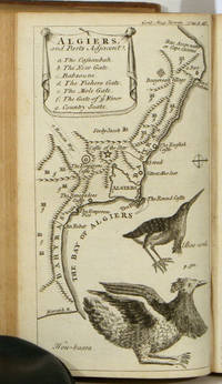
LONDON ALGIERS SOUTH AMERICA MAPS VIEWS Urban SylvanusDavid Henry Editor. Jefferys Thomas cartographer et al.
Gentleman's Magazine and Historical Chronicle January to December 1749.
London.: D. Henry and R. Cave at St. John's Gate. Volume XIX. 1749. Bound volume in leather binding leather spine intact but abraded with loss at head and tail covers detached corners bumped; 8.75 x 5.25 inches; title page and preface; 599 pp including Supplement plus index listing Essays Poetry Names etc. included in the 12 issues. Bookplate on verso of front cover of A. O. Sillifant. Reports and maps relating to South America; Heraldic Plates of Scotch and Irish Peers etc. Plates and maps are present according to the Directions for placing the Plates EXCEPT FOR: plate IV The Lion; plate IX Fireworks; plate XIII The Laocoon; Plate XIV Plan of St Petersburgh; Plate XVIII A View of the Nave of St Peter's In Rome; plate XIX The Front Prospect of Blenheim House. A chief feature of the volume is the several engraved copper-plate maps. They are listed with sheet size as follows: 1 A Plan of London and Westminster 8 x 10.25 inches; abraded top left and bottom left margins; 2 South America Drawn from the Best Maps by T. Jefferys Geographer to His Royal Highness the Prince of Wales 12 x 9.5 inches; abraded top left and bottom right margins short tear at right margin circular spotting top left; 3 Algiers and Parts Adjacent 8.25 x 4.75 very good condition. The volume also includes a number of intriguing engravings. Chief among these is A View and Plan of Noah's Ark 12 x 9.75 with 2.5 inch closed tear at right margin. Other engravings include The North East View of the Nave of the Cathedral Church of St. Paul 8.25 x 5 inches; A Perspective View of Radcliffe Library 8.25 x 5 inches; A View of Covent Garden from the Church Portico 8.25 x 5 inches; Habits of the Spaniards in Peru 8.25 x 5 inches; The Shield of Achilles as Described by Homer 8.125 x 10.25 inches; a dozen plates of the heraldic crests of Scots and Irish Peers and numerous other fascinating engravings. . D. Henry and R. Cave at St. John's Gate. hardcover
书商的参考编号 : 50819
|
|
|
LONDON - CRUCHLEY, (GEORGE FREDERICK).
Cruchley's New Plan of London Shewing all the New and Intended Improvements to the Present Time. Published May 1st 1827 - A new Edition, Improved to 1st January 1833.
London, Cruchley map Seller, (1833). (42,5 x 60 cm.) Fine engraved and handcoloured map of London. Updated to 1833. The street- indexes engraved in the margins. The map is in fine condition, plain and not folded.
书商的参考编号 : 49661

|
|
|
LONDON - CRUCHLEY, (GEORGE FREDERICK).
Cruchley's New Plan of London Shewing all the New and Intended Improvements to the Present Time. Published May 1st 1827 - A new Edition, Improved to 1st January 1833.
London, Cruchley map Seller, (1833). (42,5 x 60 cm.) Fine engraved and handcoloured map of London. Updated to 1833. The street- indexes engraved in the margins. The map is in fine condition, plain and not folded.
|
|
|
LONDON.
Index to the Streets and Places contained in the Map of London published in the Post Office Directory for 1918. BRIGHT, CLEAN COPY IN PUBLISHER'S WALLET WITH RETAINER
8vo., Index of 68pp facing large folding coloured map mounted on linen, measuring 30 x 44 ins (approx. 76 x 112 cms) folding in 36 panels to 7.5 x 5.5 ins (19 x 14 cms); the whole housed in publisher's red cloth wallet, upper board framed in blind and lettered in gilt with black retaining band (stretched through use and somewhat loose), a very good, bright, clean copty The map (scale: 4 inches to 1 mile) extends to Hampstead and Hackney in the north, Bromley and Greenwich in the east, Kennington and Walham Green in the south, and Brondesbury and Kensal Green in the west. EXTREMELY SCARCE IN THIS CONDITION.

|
|
|
Long E. B. with Barbara Long; Foreword by Bruce Catton; Maps by Barbara Long
The Civil War Day By Day: An Almanac 1861-1865
Doubleday & Company NY 1971. 1st edition. Hardcover. Fine/Fine. "In all the vast collection of books on the American Civil War there is no book like this one. It has been needed for a long time both by the student and by the man who simply likes to read about the Civil War but until now no one had the dedication or the encyclopedic knowledge to produce it. Here it is at last - an almanac or day-by-day recital down to the close conflict written by Professor E. B. Long of the University of Wyoming." Pub Info 1ST EDITION. Doubleday & Company, NY hardcover
书商的参考编号 : 1016HILT-4068

|
|
|
Long, Peter
Hidden Inns of East Anglia
Second edition. No inscriptions or marks. Minor crease to rear cover and last four pages, none to front or to spine. A lovely clean very tight copy with bright unmarked boards and no bumping to corners. 228pp. A fully illustrated guide to the more secluded traditional Inns and Pubs in Suffolk, Norfolk, Essex and Cambridgeshire.

|
|
|
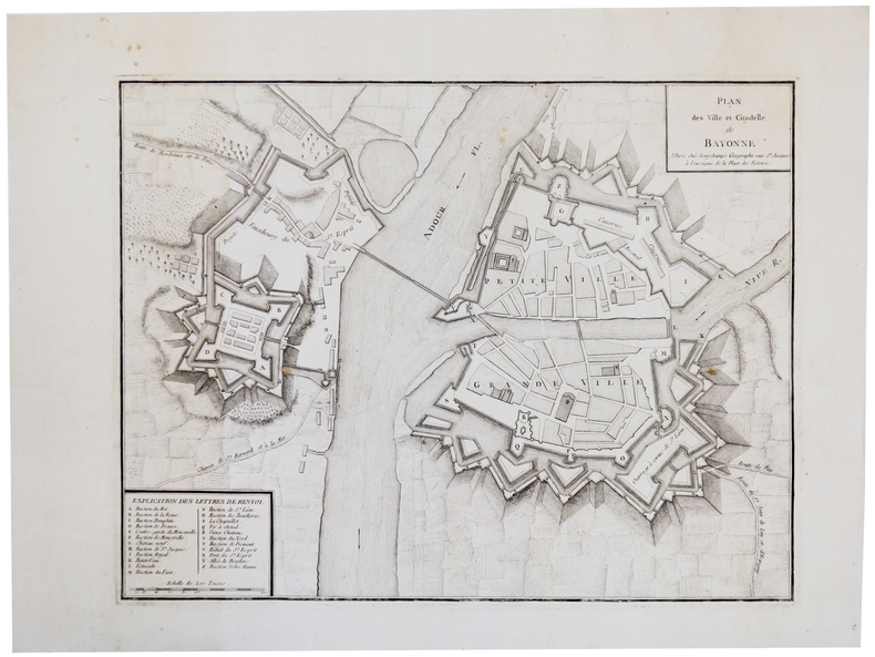
LONGCHAMPS (Sébastian G.).
[BAYONNE] Plan des ville et citadelle de Bayonne.
Paris, Longchamps, [circa 1750]. 355 x 457 mm.
书商的参考编号 : LBW-5502
|
|
 ?????????
 ?????PDF???
 RSS feed


