|
MANSO PORTO, Carmen.
Cartografía Histórica de América. Catalogo de Manuscritos de los Siglos XVIII y XIX. Presentación de Antonio López Gómez.
Madrid, 1997. Folio; XXXII pp., 143 pp., 1 h., con 108 reproducciones en color de mapas. Cubiertas originales.

|
|
|
MANSO PORTO, Carmen.
Cartografía Histórica Portuguesa. Catálogo de Manuscritos de los Siglos XVII y XVIII.
Madrid, 1999. Folio; 170 pp. Con reproducción de mapas en color. Cubiertas originales.

|
|
|
MANUSCRIPT MAP.
Grund Tegning af Fästningen og Castellet i Leystad.
No place and date (probably Denmark, late 18th century). Hand painted map in ink and water colour. 26,5 x 41 cm. Silver frame. Overall slightly foxed.
書籍販売業者の参照番号
: 39180
|
|
|
MANUSCRIPT MAP.
Grund Tegning af Fästningen og Castellet i Leystad.
No place and date (probably Denmark, late 18th century). Hand painted map in ink and water colour. 26,5 x 41 cm. Silver frame. Overall slightly foxed.
|
|
|
MANUSCRIPT MAP.
Slaget wed Zornsdorff den 25de Augusti 1758.
No place and date. (probably Denmark late 18th century). Handpainted map in ink and watercolour. 25 x 41 cm. In silver frame. Slightly foxed overall.
書籍販売業者の参照番号
: 39179
|
|
|
MANUSCRIPT MAP.
Slaget wed Zornsdorff den 25de Augusti 1758.
No place and date. (probably Denmark late 18th century). Handpainted map in ink and watercolour. 25 x 41 cm. In silver frame. Slightly foxed overall.
|
|
|
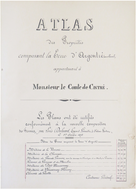
MANUSCRIT.
[ARGENTRÉ/MAYENNE] Atlas des propriétés composant la Terre d'Argentré, sous Laval, appartenant à Monsieur le Comte de Cintré. Les plans ont été rectifiés conformément à la nouvelle composition des fermes, par Louis Duluard, expert-géomètre, à Château-Gontier, le 1er octobre 1875.
Château-Gontier, 1875. In-folio ; demi-basane verte, dos lisse muet, étiquette de titre sur le premier plat (reliure de l'époque).
書籍販売業者の参照番号
: LBW-8229
|
|
|
MANUSCRIT.
[AUBE] Extrait du plan parcellaire de la commune de Barberey S.t Sulpice. Plan du château de Barberey S.t Sulpice et de ses environs appartenants à Monsieur Bruslé, préfet du département de l'Aube, Officier de la Légion d'Honneur.
[vers 1805]. En deux feuilles jointes formant un plan de 660 x 590 mm.
書籍販売業者の参照番号
: LBW-8228

|
|
|
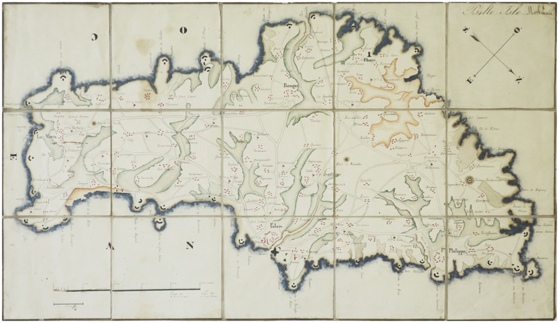
MANUSCRIT.
[BELLE-ÎLE-en-MER] Belle Isle. Morbihan.
[milieu du XIXe siècle]. En 15 section montées sur toile et repliées, formant une carte de 242 x 430 mm.
書籍販売業者の参照番号
: LBW-8230
|
|
|
Manzù, Giacomo, Italian sculptor (1908-1991).
"Andiamo nel separé". No place, c. 1940.
Signed drawing, felt-tip pen on cardboard, c. 430 x 300 mm. Erotic sketch in red felt-tip pen on ochre cardboard, the result of Manzu's collaboration with his friend and colleague Edmund Georg Pielmann.

|
|
|
MAP - AMERICA - ADOLF STIELER.
Der nordöstliche Theil der Vereinigten Staaten von Nord America Neue Bearbeitung von Ad.St. 1831.
(Gotha, Justus Perthes), 1831. Engraved map (34,5 x 43 cm.). Handcoloured in outline. Gestochen von Joh. Carl Ausfeld.
書籍販売業者の参照番号
: 55743
|
|
|
MAP - AMERICA - ADOLF STIELER.
Der nordöstliche Theil der Vereinigten Staaten von Nord America Neue Bearbeitung von Ad.St. 1831.
(Gotha, Justus Perthes), 1831. Engraved map (34,5 x 43 cm.). Handcoloured in outline. Gestochen von Joh. Carl Ausfeld.
|
|
|
MAP - AMERICA - STÜLPNAGEL, F. v.
America gezeichnet von F.v. Stülpnagel.
(Gotha, Justus Perthes), 1843. Engraved map (44 x 34 cm.). Handcoloured in outline. Having both North- and South America. Gest. von W. Behrens.
|
|
|
MAP - ARCTIC REGIONS.
Geological Map of the Arctic. Prepared by the First International Symposium on Arctic Geology sponsored by the Alberta Society of Petroleum Geologists.
Calgarry - Alberta Canada, Symposium Committee, 1960. (102 x 115 cm.). Large colourprinted circular map of the Arctic Regions. Folded. Well-preserved.
書籍販売業者の参照番号
: 55325
|
|
|
MAP - ARCTIC REGIONS.
Geological Map of the Arctic. Prepared by the First International Symposium on Arctic Geology sponsored by the Alberta Society of Petroleum Geologists.
Calgarry - Alberta Canada, Symposium Committee, 1960. (102 x 115 cm.). Large colourprinted circular map of the Arctic Regions. Folded. Well-preserved.
|
|
|
MAP - AUSTRALIA - STÜLPNAGEL, F. v.
Festland von Australien und benachbarte Inseln.
(Gotha, Justus Perthes), 1841. Engraved map (35,5 x 43,5 cm.). Handcoloured in outline. Fine and clean.
書籍販売業者の参照番号
: 55741
|
|
|
MAP - AUSTRALIA - STÜLPNAGEL, F. v.
Festland von Australien und benachbarte Inseln.
(Gotha, Justus Perthes), 1841. Engraved map (35,5 x 43,5 cm.). Handcoloured in outline. Fine and clean.
|
|
|
MAP - BRAZIL. - EDWARD STANFORD.
Brazil from official and other Sources prepared in the international Bureau of the American Republics, Williams C. Fox, Director.
London, Edward Stanford, 1905. (95 x 95,5 cm.). A large lithographed map of Brazil, lithographed in colours, original linen-backed and folded in 35 sections. Folded in the original cloth-case with the original printed title-label preserved. A fine copy.
書籍販売業者の参照番号
: 57772
|
|
|
MAP - BRAZIL. - EDWARD STANFORD.
Brazil from official and other Sources prepared in the international Bureau of the American Republics, Williams C. Fox, Director.
London, Edward Stanford, 1905. (95 x 95,5 cm.). A large lithographed map of Brazil, lithographed in colours, original linen-backed and folded in 35 sections. Folded in the original cloth-case with the original printed title-label preserved. A fine copy.
|
|
|
MAP - GIBRALTAR.
Nueba Vista Gibraltar. 1782.
Wien, L. Hochenleiter, um 1782. (22 x 37 cm.). Engraved map (bird-eye-view) with ships in the sea, fortification and bombardment. Text in Spanish. Mildly brownspotted.
書籍販売業者の参照番号
: 55917
|
|
|
MAP - GIBRALTAR.
Nueba Vista Gibraltar. 1782.
Wien, L. Hochenleiter, um 1782. (22 x 37 cm.). Engraved map (bird-eye-view) with ships in the sea, fortification and bombardment. Text in Spanish. Mildly brownspotted.
|
|
|
MAP - GIBRALTAR.
Plan der Berühmten Vestung Gibraltar belagert von den Spaniern und Frantzosen seit Anno 1779.
(Frankfurt am M., um 1780). (36 x 26 cm.) Engraved handcoloured map/plan of Gibraltar with text and with insets of Southern Span and North Africa around Ceuta and Tanger. A stamp in upper left corner. I.M. Zell, sculp. (Johann Michael Zell)Some brownspots.
書籍販売業者の参照番号
: 55916
|
|
|
MAP - GIBRALTAR.
Plan der Berühmten Vestung Gibraltar belagert von den Spaniern und Frantzosen seit Anno 1779.
(Frankfurt am M., um 1780). (36 x 26 cm.) Engraved handcoloured map/plan of Gibraltar with text and with insets of Southern Span and North Africa around Ceuta and Tanger. A stamp in upper left corner. I.M. Zell, sculp. (Johann Michael Zell)Some brownspots.
|
|
|
MAP - IRAN und TURAN - STÜLPNAGEL, F. v.
Iran und Turan (Persien, Afghanistan, Beludschistan, Turkestan). Neue Bearbeitung von F. v. Stülpnagel.
(Gotha, Justus Perthes), 1843. Engraved map (35,5 x 44 cm.). Handcoloured in outline.
書籍販売業者の参照番号
: 55747
|
|
|
MAP - IRAN und TURAN - STÜLPNAGEL, F. v.
Iran und Turan (Persien, Afghanistan, Beludschistan, Turkestan). Neue Bearbeitung von F. v. Stülpnagel.
(Gotha, Justus Perthes), 1843. Engraved map (35,5 x 44 cm.). Handcoloured in outline.
|
|
|
Map collectors' series
Map collectors' series ; Map Collectors' Circle [10 issues]
Ten issues in offwhite printed wraps; approx. 40-60p per issue, b&w illus., maps ; 25 cm Offerd as a lot only. Includes Number 5 Printed Maps of Tasmania ; No.16 Dictionary of Mapmakers Part I ; No. 32 French Explorer Maps of New Zealand; No. 39 Comparative Cartography ; No. 40 Dictionary of Mapmakers Part III; No. 44 Printed Maps of New South Wales, 1773-1873 ; No. 45 Smith's Virginai and its Derivatives ; No. 68 Printed Maps of America Part 1 by Tooley ; No. 69 Printed Maps of Amerca Part II by Tooley; No. 80 Printed Maps of America Part III by Tooley. || Cartography; Maps. Maps -- Bibliography. Cartes -- Collectionneurs et collections. Maps, Cartas; Bibliography.
|
|
|
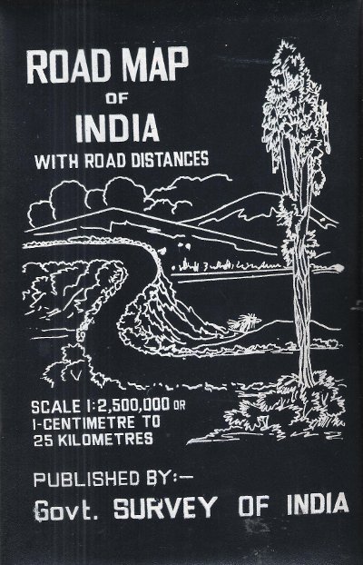
MAP OF INDIA
Road Map of India with Road Distances
Gouvernement Survey of India 1977 150 Cm x 118 Cm Carte en couleurs , imprimée sur très bon papier collé sur tissu tramé , se repliant dans une pochette plastifiée . Echelle 1 cm pour 25 kilomètres . Tableau des distances entre les grandes villes . Pour voyager en Inde ou pour afficher au mur . Trés belle carte .- 1 p. , 600 gr.
書籍販売業者の参照番号
: 015281
|
|
|
MAP OF INDIA
Road Map of India with Road Distances
Carte en couleurs , imprimée sur très bon papier collé sur tissu tramé , se repliant dans une pochette plastifiée . Echelle 1 cm pour 25 kilomètres . Tableau des distances entre les grandes villes . Pour voyager en Inde ou pour afficher au mur . Trés belle carte .- 1 p. , 600 gr.

|
|
|
Map. Florida. Cuba
Shell Map Of Florida And Cuba
Chicago: H. M. Gousha Company. Very Good. Measures approximately 18 x 29.5 inches 7 folds a few small breaks at folds. <br/><br/>With an inset map of Cuba. H. M. Gousha Company unknown
書籍販売業者の参照番号
: 4883
|
|
|
Map. Texas
Highway Map And Guide Of Texas
Aurora MO: Mid-West Map Co. 1925. Good. Measures approximately 17 x 28 inches 4 folds a few punctures at folds. Scarce. <br/><br/>On the verso are 324 listings of authorized garages for repairs and supplies. The panhandle appears to the left where New Mexico would be. " "Authorized guide & map service of Texas". Mid-West Map Co. unknown
書籍販売業者の参照番号
: 4882
|
|
|
Map. Washington State
Highways State Of Washington
Olympia WA: Department of Highways 1937. Very Good. Measures approximately 19 x 27.5 inches 4 folds lightly edgeworn toned <br/><br/>The Washington State highway maps series began in 1933. Department of Highways unknown
書籍販売業者の参照番号
: 4884
|
|
|
Mapas Naturismo
Costa Rica Road Map Naturismo 1:500K English & Spainish
2012-06-30. New. Ships with Tracking Number! INTERNATIONAL WORLDWIDE Shipping available. May be re-issue. Buy with confidence excellent customer service! unknown
書籍販売業者の参照番号
: 3981126947n ISBN : 3981126947 9783981126945

|
|
|
Mapas Naturismo
Costa Rica Road Map Naturismo 1:500K English & Spainish
2012-06-30. Good. Ships with Tracking Number! INTERNATIONAL WORLDWIDE Shipping available. May not contain Access Codes or Supplements. May be re-issue. May be ex-library. Shipping & Handling by region. Buy with confidence excellent customer service! unknown
書籍販売業者の参照番号
: 3981126947 ISBN : 3981126947 9783981126945

|
|
|
Mapas Naturismo
Nicaragua Karte mapa de Tourismo 1:500.000english & espanol / Tourismus- und Straßenkarte
unknown. gebraucht gut Originalbroschur Neu Verlagsfrisch. 90x68 cmbeidseitig . Mit Detailkarten von: -Rio San Juan 1:200.000 -Island Ometepe 1:200.000 -Delta RÃo San Juan 1:10.000 -Big and Little Corn Island 1:75.000 -und neu: zusätzlich: Isletas bei Granada 1:75.000 -zahlreiche Aktualisierungen an der Karibik Auf Anfrage per E-Mail können Sie die bei uns bestellten Artikel auch in unserer Buchscheune 01796 Struppen Mo.-Fr. 9-16 Uhr oder im Antiquariat Schloss Pillnitz 01326 Dresden Mo.-So. 10-18 Uhr abholen. unknown
書籍販売業者の参照番号
: B10625

|
|
|
MAPMEDIA.
Sokak sokak Ankara kent atlasi: 1/10.000.
Fine Turkish Paperback. Roy. 8vo. (24 x 17 cm). In Turkish. 224 p., plan, color ills. Sokak sokak Ankara kent atlasi: 1/10.000. Ankara city atlas (guide) street by street with a huge plan.
|
|
|
Maps
Asia Drawn by Electa Curtis. Pen & ink map of Asia drawn by NY state student
Very good overall. A large child's manuscript map of Asia ca. 1810 from the west coast of Africa to the Tasman Sea and from the Arctic Ocean to Tasmania. Australia is called "New Holland" and "New South Wales" covering the whole east coast. Off the WA coast are marked the "Tryal Rocks" and "Dampiers Rock". Other countries include India "Hindoostan"; China is called both "China" & "Chinese Tartary" & "Thibet" appears separately is marked as a large independent country north of India and east of China; Korea "Corea"; Japan is "Iles of Japan Isles of Zezo and Iles of Leeo Keeo"; "Phillippine Iles"; "Burmah" encompasses Burma Thailand Vietnam Cambodia & Laos; Russia is "Russia in Asia" & "Kamchatka"; "Arabia"; "Persia" "Turkey" "New Guinea" Indonesia is "Sumatra Java Borneo Moluccas Is. & Celebes". The Straights of Malacca are noted. Off the Australian coast both "Dampiers Rocks" and "Tryal Rocks" are marked. Tasmania appears as an island. The Arctic Ocean is named with "Novaya Zembla" marked. Off of Kamchatka islands marked include Beerings I. and Andrean Islands now Andrean of Islands in the Aleutian chain. The artist Electa Curtis was from western New York state and was born ca. 1793. Longitude and latitude readings in pen. 17 x 22" drawn in pen with original outline color and the border colored yellow. In an early frame and a little browned from the early wooden backing with a slight tidemark in the lower right corner. A wonderfully crude map of the Eastern Hemisphere. <br/><br/> unknown
書籍販売業者の参照番号
: 15636

|
|
|
MAPS
BIRD'S EYE VIEW OF NARA
1900. MAPS. BIRD'S EYE VIEW OF NARA. Osaka: K. Kawakami c. 1900. Folding panorama c. 22" x 25" colored green and view. Some notes by contemporary tourist added to key. Heavily worn at folds and edges partly separated at folds. unknown
書籍販売業者の参照番号
: 42458
|
|
|
MAPS
BIRD'S EYE VIEW OF NARA
1900. MAPS. BIRD'S EYE VIEW OF NARA. Osaka: K. Kawakami c. 1900. Folding panorama c. 22" x 25" colored green and view. Some notes by contemporary tourist added to key. Heavily worn at folds and edges partly separated at folds. unknown books
書籍販売業者の参照番号
: 42458
|
|
|
maps
Etablissement Militaire de St. Bernard. Atlas des batiments
c. early 19th century. Hardcover. Very Good. Half cloth and marbled paper over boards handwritten label on upper board; oblong folio 460 x 360 mm; entirely handwritten and drawn in black ink on the rectos only with "tableau des batiments militaires" and 7 maps. Boards heavily scuffed; binding shaken; some dusty finger-smudges here and there. <br/><br/> hardcover
書籍販売業者の参照番号
: LD7400
|
|
|
maps
Etablissement Militaire de St. Bernard. Atlas des batiments
c. early 19th century. Hardcover. Very Good. Half cloth and marbled paper over boards handwritten label on upper board; oblong folio 460 x 360 mm; entirely handwritten and drawn in black ink on the rectos only with "tableau des batiments militaires" and 7 maps. Boards heavily scuffed; binding shaken; some dusty finger-smudges here and there. <br/><br/> hardcover books
書籍販売業者の参照番号
: LD7400
|
|
|
MAPS
MAPS FOR THE JEWISH SCHOOL PORTFOLIO 1
1968. MAPS MAPS FOR THE JEWISH SCHOOL PORTFOLIO 1. New York: Jewish Education Committee Press January 1968. Ten color maps 9 1/2 x 14 inches plus bonus map of the Six Day War. Includes maps of ancient history and contemporary Israel as well as Eastern Europe. Maps fine original envelope has closed tears light soil. unknown
書籍販売業者の参照番号
: 79979
|
|
|
MAPS
MAPS FOR THE JEWISH SCHOOL PORTFOLIO 1
1968. MAPS MAPS FOR THE JEWISH SCHOOL PORTFOLIO 1. New York: Jewish Education Committee Press January 1968. Ten color maps 9 1/2 x 14 inches plus bonus map of the Six Day War. Includes maps of ancient history and contemporary Israel as well as Eastern Europe. Maps fine original envelope has closed tears light soil. unknown books
書籍販売業者の参照番号
: 79979
|
|
|
Maps
Maps to Accompany Annual Report 1906
Ottawa: Queen's Printer 1906. Wrappers 5pp. Very good. 5 maps in original card stock envelope. Maps are whole and complete though starting at folds some neatly repaired with tape. Printed envelope states "Maps 1906 - R.N.W. Mounted Police" and 3 map titles. Maps include: 1 Rt. Hon Sir Wilfred Laurier G.C.M.G.President of the Privy Council CANADA TERRITORIAL DIVISIONS. 2 TERRITORIAL DIVISION of CANADA. 3 MOUNTED POLICE STATIONS in NORTH-WESTERN CANADA - EASTERN SHEET 4 MOUNTED POLICE STATIONS in NORTH-WESTERN CANADA - WESTERN SHEET and 5 MOUNTED POLICE STATIONS in ALBERTA and SASKATCHEWAN. Queen's Printer Paperback
書籍販売業者の参照番号
: 115053
|
|
|
MAPS
MCMULLEN COUNTY MAP GENERAL LAND OFFICE
1877. reprint. VERY GOOD. Xerox 17 x 25 inches. Details include abstracts and names. Flat rolled. <br/><br/> unknown
書籍販売業者の参照番号
: 12957
|
|
|
Maps
Old Maps of America 1572 - 1848 Part 2
NY: Henry Stevens Son & Stiles 35 pages & Illustrated - Fair only. Soft Cover. Fair. Henry Stevens, Son & Stiles Paperback
書籍販売業者の参照番号
: FG 3131
|
|
|
Maps
Seedtime On The Cumberlands
NY: Macmillan & Co. 1960. 1st Edition 1st Printing. Hardcover. Very Good/Very Good. Clipped and slight sunned DJ. One sentence underlined on the Inside cover of DJ. An early map of Kentucky. Green cloth. 8 vo449 pages <br/> <br/> Macmillan & Co. hardcover
書籍販売業者の参照番号
: 25897
|
|
|
Maps
Southern Appalachian Region Maps - VA W VA MD TN
International Geological Congress 1900. no dates but guessing early to mid 1900's - 21 Maps: 1.Route Map Hyattstown to Frederick MD plate 3 2.Route Map Frederick MD to Charles Town W VA plate 4 3. Geologic Map and Sections Area NE of Harpers Ferry W VA plate 5 4. Route Map Hagerstown MD to Cacapon Mountain W VA plate 6 5. Section along Route Hancock to Cumberland MD plate 10 6. Route Map and Sections New Creek W VA to Virginia State Line plate11 7. Route Map and Section W VA state line to Winchester VA plate 12 8. Route Map Winchester to Luray VA and Section across Shenandoah Valley and Massanutten Mountain Plate 13 9. Route Map and Sections Mount Jackson to Staunton VA plate 14 10. Route Map and Sections Staunton to Healing Springs VA plate 15 11. Route Map and Sections Helaing Springs to Lexington VA plate 16 12.Route Map Natural Bridge to Roanoke VA and Section through Read Mountain Fenster plate 18 13. Route Map and Sections Elliston to Glenlyn VA plate 19 14. Route Map Glenlyn to Lebanon VA plate 20 15. Route Map and Section Lebanon to Bristol VA plate 21 16. Route Map Bristol to Pennington Gap VA plate 22 17.Map and Section of Cumberland Overthrust Block plate 23 18. Route Map Cumberland Gap to Morristown TN plate 24 19. Generalized Map and Section of the Cherokee Mountain Klippe TN plate 25 20. Route Map Bristol VA to Mountain City TN and Section from Delaney Mountain to Mountain City plate 26 21. Map of Fenster in Overthrust Block of Rome Formation 3 Miles 4.8 Kilometers East of Wytheville VA Plate 27. Maps. Good. International Geological Congress Paperback
書籍販売業者の参照番号
: FG 2016-26
|
|
|
MAPS
Special Edition Bulletin: Psychedelic Science Spring 2017
Santa Cruz: Multidisciplinary Association for Psychedelic Studies 2017. First Edition. Softcover Paperback. Near Fine Condition. 28cm x 21cm. 48 pages black and white photographs and illustrations. Illustrated saddle-stapled wrappers. Volume XXVII Number 1. An overview of MAPS activities plus articles on Psychedelic therapy MDMA research Psychedelics and Music and microdosing. Very minor general wear. Shipped Weight: .17 kilos. BZDB407 Ethnopharmacology & Psychedelia; Special Edition Bulletin Psychedelic Science Spring 2017 MAPS Multidisciplinary Association for Psychedelic Studies paperback
書籍販売業者の参照番号
: 0013479

|
|
|
MAPS
Special Edition Bulletin: Psychedelics and Policy Spring 2015
Santa Cruz: Multidisciplinary Association for Psychedelic Studies 2015. First Edition. Softcover Paperback. Near Fine Condition. 28cm x 21cm. 44 pages black and white photographs and illustrations. Illustrated saddle-stapled wrappers. Volume XXV Number 1. An overview of MAPS activities plus articles on psychedelics and politics decriminalization ayahuasca globalization Boom Festival and more. Very minor general wear. Shipped Weight: .16 kilos. BZDB407 Ethnopharmacology & Psychedelia; Special Edition Bulletin Psychedelics and Policy Spring 2015 MAPS Multidisciplinary Association for Psychedelic Studies paperback
書籍販売業者の参照番号
: 0013478

|
|
|
Maps
Stanford Map Of The Danubian Principalities Prepared From The Vienna Map 2 Maps North and South
Edward Stanford London unknown circa 1857 First Edition thus. Paperback. maps show slight toning a few stains & marks to back of linen otherwise in very good condition case bumped and rubbed with scuffed corners. approximately 54 x 54 inches. dissected linen backed colour map in two parts: North - from Konigr Ungar & Scharzes Meer to Serbia Bulgarien and Schwarzes Meer: South - Vusitrin & Griechenland to Scharzes Meer Meer von Marmara Kleinasien & Archiplagus Weiss. Both 71 X 137 cm legend in English on the North map boundaries carriage trails battlefields harbours in German scale of English miles 69 to one degree boxed set linen backed maps with marbled paper ends cloth covered slipcase Edward Stanford hardcover
書籍販売業者の参照番号
: 32586
|
|
 検索結果のメールを受信する
 PDFファイルの検索結果をダウンロード
 RSSフィード


