|
MAPS: ORANGE COUNTY CA
Plat Book of Orange County California.
Los Angeles/San Francisco/Sacramento: H. S. Crocker Company 1913. First edition of the first plat map atlas of Orange County. Folio 15 1/2 x 18 1/4 inches. Printed on rectos only. 62 4 pp. Pagination starts at p. 4 as issued. Publisher's half black morocco over blue cloth gilt cover lettering. Silver-fishing to front endpaper only maps are fine. Front hinge expertly repaired. OCLC only locates 4 copies. These 4 copies bear three different dates but are surely the same copy as the only findable date in the atlas is that given at the bottom of plate 8 1912. A very good copy of this very scarce book. Orange County is one of the newest counties in Southern California and one of the wealthiest. As of the 2010 census the population was 3010232 making it the third-most populous county in California the sixth-most populous in the United States and more populous than twenty-one U.S. states. The population in 1913 was about 40000. The growth of population in Southern California led the California legislature to divide Los Angeles County and create Orange County as a separate political entity on March 11 1889. The county is said to have been named for the citrus fruit in an attempt to promote immigration by suggesting a semi-tropical paradise�a place where anything could grow. The maps are as follows; 4; Orange County Supervisorial Districts 5; Orange County Judicial Townships 6; Orange County School Districts 7; Orange County Road Districts 8; Orange County Proposed Good Roads System September 1912 9; City of Santa Ana 10; City of Santa Ana 11; City of Santa Ana 12; City of Santa Ana 13; City of Santa Ana 14; City of Santa Ana 15; City of Santa Ana 16; City of Santa Ana 17; Nine Photographs of local businesses 18; City of Orange 19; Orange Road District 20; City of Fullerton 21; City of Fullerton 22; San Juan Capistrano 23; San Juan Road District 24; Nine Photographs 25; City of Anaheim 26; City of Anaheim 27; City of Anaheim 28; City of Anaheim 29; Anaheim Road District 30; Olive Road District and Part of Yorba Road District 31; Nine Photographs 32; Garden Grove Road District 33; Placentia and Vicinity 34; La Habra Road District 35; Buena Park Road District 36; Westminster Road District 37; City of Stanton 38; Los Alamitos Road District 39; Nine Photographs 40; Tustin Road District 41; Bolsa Road District 42; Newhope Road District 43; Irvine Subdivision 44; Trabuco Road District 45 ; Part of Yorba Road District 46; Silverado Road District 47; Delhi Road District 48; City of Newport Beach 49; Newport Road District 50; El Toro Road District 51; Four Photographs 52; Laguna 53; Part of Laguna Road District 54; Laguna Cliffs Number Two 55; McKnights Addition Section A Map of La Habra Road District and Town of Brea 56; Balboa Island 57; East Side Villa Tract and Vista del Mar Huntington Beach Sheet A 58; Part of Huntington Beach Sheet B 59; Part of Huntington Beach Sheet C 60; Part of Huntington Beach Sheet D 61; Part of Huntington Beach Sheet E 62; Anaheim Sanitarium Nine Photographs 63; Ten Printed Advertisements 64; Ten Printed Advertisements 65; Nine Printed Advertisements 66; Table of Contents Index of Views H. S. Crocker Company hardcover
书商的参考编号 : 73652
|
|
|
MAPS; ENGLAND William Darton
THE COUNTIES OF ENGLAND: WITH GENERAL MAPS OF NORTH AND SOUTH WALES
London: Willaim Darton and Son 1835. Half Leather. Very Good binding. Darton's Counties of England complete with 42 decorative engraved map 3 of which are folding with original hand-coloring. The maps have attractive vignettes of sights within each county and references to the "Hundreds" and "Market Towns and Market Days". Some offsetting as is usual. This is a later state of "Complete Atlas of the English Counties" begun by Thomas Dix of North Walsham and completed by William Darton in 1822. Undated but the imprint on most maps reads "London: William Darton & Son 58 Holborn Hill" which was Darton's company name only between 1835 and 1837. Rebacked in calf with a new spine label. Very Good binding. Willaim Darton and Son unknown books
书商的参考编号 : 291674

|
|
|
maps; French Revolution
Maps of Sites of the War and Counter-Revolution of France 1792-1794
unknown: unknown likely early 1800s. Ephemera. Very Good. A collection of 8 engraved maps 420 x 280 mm including wide margins numbered in Arabic or Roman numerals see below otherwise seemingly uniform. From an unknown source. It includes: 1 Bombardement de Lille par l'Armee Autrichienne en 1792 with the stamp of Depot de la Guerre Bibliotheque in the top margin; 2 Siege de la Citadelle d'Anvers par l'Armee Francaise en 1792; III Siege de Valenciennes par l'Armee Coalisee Anglaise Hannovrienne et Autrichienne en 1793; VIII Siege d'Ypres par l'Armee Francaise en 1794; IX Siege de Charleroy par les Francais en 1794; X Siege de Landrecies par les Francais en 1794; XI Siege du Quesnoy par les Francaise in 1794; and XIII Siege de Nieuport par l'Armee Francaise en 1794. A bit foxed; flattened crease down the middle from folding these were perhaps pulled from a book where they were mounted on stubs along the crease. <br/><br/> [unknown] unknown
书商的参考编号 : D7401
|
|
|
maps; French Revolution
Maps of Sites of the War and Counter-Revolution of France 1792-1794
unknown: unknown likely early 1800s. Ephemera. Very Good. A collection of 8 engraved maps 420 x 280 mm including wide margins numbered in Arabic or Roman numerals see below otherwise seemingly uniform. From an unknown source. It includes: 1 Bombardement de Lille par l'Armee Autrichienne en 1792 with the stamp of Depot de la Guerre Bibliotheque in the top margin; 2 Siege de la Citadelle d'Anvers par l'Armee Francaise en 1792; III Siege de Valenciennes par l'Armee Coalisee Anglaise Hannovrienne et Autrichienne en 1793; VIII Siege d'Ypres par l'Armee Francaise en 1794; IX Siege de Charleroy par les Francais en 1794; X Siege de Landrecies par les Francais en 1794; XI Siege du Quesnoy par les Francaise in 1794; and XIII Siege de Nieuport par l'Armee Francaise en 1794. A bit foxed; flattened crease down the middle from folding these were perhaps pulled from a book where they were mounted on stubs along the crease. <br/><br/> [unknown] unknown books
书商的参考编号 : D7401
|
|
|
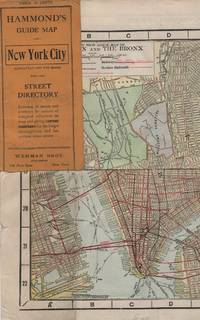
Maps; New York City
HAMMOND'S GUIDE MAP OF NEW YORK CITY: Manhattan and the Bronx
New York: Wehman Brothers Publishers 1913. Very good. Folding color map. Measuring approximately 18" x 36" when unfolded. In original printed card wrapper. Verso a thorough printed street index. Mild handling wear toning. A few tiny holes near fold corners. Overall well preserved; very good. <br/><br/>An impressive color map of the island of Manhattan and the Bronx. Scale is 1" equals 1/2 mile and includes railroads subways elevated railroads surface railroads and proposed railroads. An uncommon early 20th Century New York City street map. Wehman Brothers Publishers unknown
书商的参考编号 : 15611
|
|
|
Maps; New York City
HAMMOND'S GUIDE MAP OF NEW YORK CITY: Manhattan and the Bronx
New York: Wehman Brothers Publishers 1913. Very good. Folding color map. Measuring approximately 18" x 36" when unfolded. In original printed card wrapper. Verso a thorough printed street index. Mild handling wear toning. A few tiny holes near fold corners. Overall well preserved; very good. <br/><br/>An impressive color map of the island of Manhattan and the Bronx. Scale is 1" equals 1/2 mile and includes railroads subways elevated railroads surface railroads and proposed railroads. An uncommon early 20th Century New York City street map. Wehman Brothers Publishers unknown books
书商的参考编号 : 15611
|
|
|
Marcel (Professeur)
Tous me tours dévoilés nouveaux tours de cartes et physique amusante expliqués pour rire en société
1753 Marcel lemoine (studio physico) 175 rue du temple, café de la monnaie Paris 3eme plaquette In8 22 pages
书商的参考编号 : 5928

|
|
|
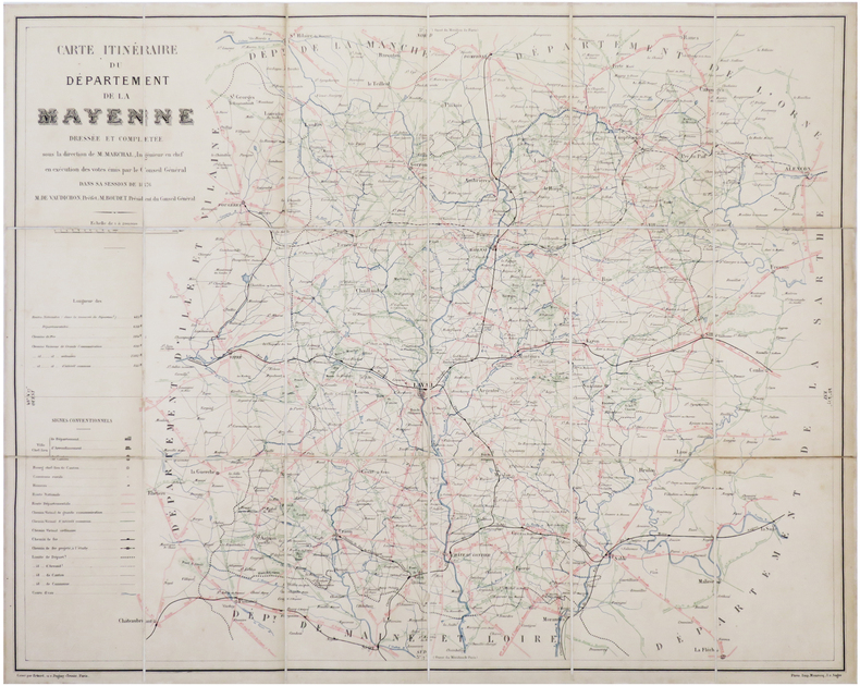
MARCHAL (Louis).
[MAYENNE] Carte itinéraire du département de la Mayenne.
1876. En 18 sections montées sur toile et reliées, formant une carte de 569 x 712 mm ; titre manuscrit au dos.
书商的参考编号 : LBW-7026
|
|
|
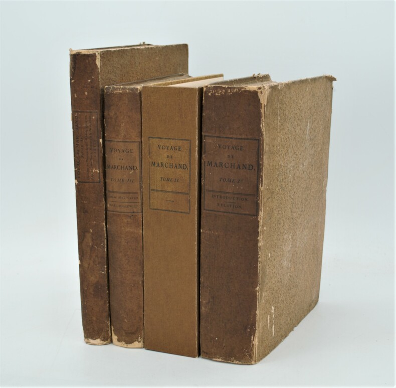
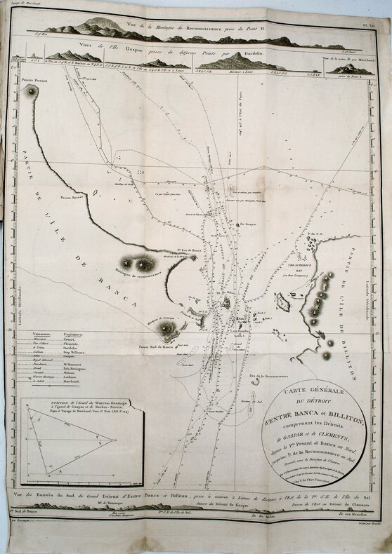
MARCHAND (Étienne) ,FLEURIEU (Charles-Pierre Claret de)
Voyage autour du monde, pendant les années 1790, 1791, et 1792, précédé d’une introduction historique ; auquel on a joint des recherches sur les terres australes de Drake, et un examen critique du voyage de Roggeween.
Paris, De l’Imprimerie de la République, An VI-An VIII [1798-1800]. In-4 (28x22 pour les T.I et II,31,5x24 pour le T .IV) ,xii, cxliv, 628, [3] ; xvi, 676, [2] ;[xi], 431, [1];[2],viii, 158pp, relié couverture d’attente éditeur en cartonnage beige chiné , non rogné , le tome IV n’étant pas ouvert ,défauts d’usage , papier à grandes marges et bruni aux bords ,mouillures au tome III , quelques rousseurs ,tome II reliure demi cuir sous emboîtage à l’identique.Tome I,III et IV premier tirage , Tome II ,1841, ,édition originale remise en vente en 1841 avec un titre de relai portant la mention fictive , "nouvelle édition"(quelques exemplaire imprimés en 1798 n'avaient pas trouver preneur) .L’illustration comprend 16 planches dépliantes gravées sur cuivre, numérotées de I à XV, dont une planche notée VI bis, toutes réunies dans le 4éme tome . Les 15 cartes gravées par Bouclet, Collin, Tardieu, Fortier, etc., levées pour les côtes nord-ouest de l’Amérique du Nord, les îles des Marquesas de Mendoça (îles Marquises), les îles Tupaya (dans l’actuelle Polynésie française), la baie de Tchinkîtâné (actuelle Sitka Sound, près de la ville de Sitka en Alaska), les îles de la Reine-Charlotte (archipel canadien au large de la Colombie-Britannique), les îles Sandwich (Hawaï), le détroit de Magellan, le détroit entre les îles Banca et Billiton (actuelle Belitung) en Indonésie, etc., et une jolie planche à caractère ethnographique (n°V) représentant des échasses de Whûtahô, une des îles de l’archipel des Marquises. Le tome I renferme un tableau dépliant donnant les concordances de mots français avec la langue de Wahîtahô et le tome IV les Observations sur la division hydrographique du Globe .
书商的参考编号 : PHO-657
|
|
|
MARCHAND (Étienne) – FLEURIEU (Charles-Pierre, Claret de), rédacteur
Voyage autour du monde, pendant les années 1790, 1791, et 1792, précédé d'une introduction historique, auquel on a joint des recherches sur les terres australes de Drake, et un examen critique du voyage de Roggeween ... par C. P. Claret Fleurieu
Deuxième reliure de la première édition. Édition originale in-4 sur grand papier, remise en circulation en 1841 avec un nouveau titre avec la mention fictive "nouvelle édition" (quelques exemplaires imprimés en 1798 n'avaient toujours pas trouvé preneur). Une édition octavo en six volumes a également été publiée. in-4 ,y compris l'atlas. Avec 16 (10 dépliantes) dont 15 cartes gravées, 1 planche gravée et table dépliante. - Beau demi-cuir contemp , dos lisse avec titre et tomaison , petits manques au dos , quelques mouillures intermittentes et vieille trace d’humidité (T1), déchirure carte hydrographique sans manque. xii, cxliv, 628, [3] ; xvi, 676, [2] ;[xi], 431, [1];[2],viii, 158pp.
书商的参考编号 : PHO-1092
|
|
|
Marco Polo
Gran Canaria Marco Polo Pocket Guide (Marco Polo Travel Guides)
Book in as new unread condition. 140pp. Travel guide to Gran Canaria with road atlas and pull-out map. Map looks unused.
|
|
|
MARCOLINI (Francesco).
LE INGENIOSE SORTI composte per Francesco Marcolini da Forli. Intitulate Giardino di Pensieri, Novamente Ristampate, e in Novo et Bellissimo Ordine Riformate.
1550 Venise, Francesco Marcolini, juillet 1550. Petit in-folio (225 X 322) demi-vélin ivoire, plats de papier dominoté, auteur, titre, lieu d'édition et date calligraphiés au dos en rouge et noir (reliure XVIIIe) ; A-Z4, Aa-Cc4 : 104 feuillets. A partir des figures des philosophes (page 64) il est donné un même numéro pour deux pages. Nombreuses restaurations aux premiers feuillets, l'encadrement architectural du portrait de l'auteur est masqué par un feuillet de doublure, marges du feuillet 43/44 rognées.
书商的参考编号 : 003307
|
|
|
MARCUCCI Giacomo (Attivo a Roma tra il 1620 e il 1640 circa)
Roma
Opera per la prima volta pubblicata nel rarissimo "Giardino del Mondo dove si vede sculpite le citta principale ditalia con le eccelse fabriche antiche e chiese palazzi guglie colonne giardini e fonatene et archi trionfali di Roma" stampato a Roma [s.d. ma circa 1625-30].Si tratta di di un volume "di piccolo formato e privo di indice, è dedicato a Federico Cesi, dondatore dell'Accademia dei Lincei, morto nel 1630. Nella dedica, che compare dopoil titolo figurato, l'autore descrive i motivi che lo hanno spinto ad allestire l'opera" (cfr. Bellucci-Valerio, Piante e vedute di Napoli dal 1600 al 1699, p. 76).Le opere, di piccolo formato, sono una derivazione di quelle di Francesco Valegio contenute in "Descrizione La Raccolta di le piu illustri et famose citta di tutto il mondo" della fine del '500.I rami del Marcucci confluirono nella più celebre tipografia De Rossi, e ristampate nella "Raccolta delle principali città d’Italia intagliate con tutte le contrade, e palazzi di esse" edita a Roma nel 1643 da Giovambattista de Rossi. Una successiva ristampa della stessa è nota a cura di Carlo Losi nel 1773. La pianta, molto rara, viene per la prima volta descritta da Scaccia Scarafoni, che erroneamente ne fornisce l'errata datazione del 1547. Marigliani, nel datarla erroneamente al 1595 circa, ne fornisce la prima accurata descrizione: "è una copia della pianta di Valegio realizzata nell'ultimo decennio del '500 con lievissime differenze solo nella raffigurazione di San Pietro, di cui si vedono le cupole laterali, Santa Maria Maggiore ed il Colosseo più correttamente raffigurato con una parte dell'emiciclo esterno mancante"(cfr. Marigliani p. 164).Incisione in rame, in perfette condizioni. Rarissima. Bibliografia Scaccia Scarafoni (1939): n. 132; Frutaz (1960) n. 139 (nota); Marigliani (2007): p. 164, n. 65. A small and very rare map of Rome, for the first time published in the very rare "Giardino del Mondo dove si vede sculpite le citta principale ditalia con le eccelse fabriche antiche e chiese palazzi guglie colonne giardini e fonatene et archi trionfali di Roma" printed in Rome [s.d. but about 1625-30]. It is a volume of small format and without index, dedicated to Federico Cesi, founder of the Accademia dei Lincei, who died in 1630. In the dedication, which appears after the illustrated title, the author describes the reasons that pushed to prepare the work (see Bellucci-Valerio, Piante e vedute di Napoli dal 1600 al 1699, p. 76). The small-sized works are a derivation of those by Francesco Valegio contained in "Descrizione La Raccolta di le piu illustri et famose citta di tutto il mondo" from the end of the 16th century. Marcucci's platess flowed into the most famous De Rossi typography, and reprinted in the "Raccolta delle principali città d’Italia intagliate con tutte le contrade, e palazzi di esse" published in Rome in 1643 by Giovambattista de Rossi. A subsequent reprint of the same is known by Carlo Losi in 1773. The very rare map is described for the first time by Scaccia Scarafoni, who erroneously gives the wrong date of 1547. Marigliani, erroneously dating it to about 1595, provides the first accurate description: "it is a copy of the map of Valegio built in the last decade of the 16th century with very slight differences only in the depiction of St. Peter, of which you can see the side domes, Santa Maria Maggiore and the Colosseum more correctly depicted with a part of the external hemicycle missing "(see Marigliani p . 164). Copper engraving, in perfect condition. Extremely rare. Bibliografia Scaccia Scarafoni (1939): n. 132; Frutaz (1960) n. 139 (nota); Marigliani (2007): p. 164, n. 65.

|
|
|
Mardesic, S. - Segal, J. (editors)
Shape Theory: the Inverse System Approach (North-Holland Mathematical Library)
Mm 150x225 Volume in copertina rigida originale, xv-378 pagine. Copia ottima, spedizione in 24 ore dalla conferma dell'ordine.
|
|
|
Margaret Cousins; Illustrator Photographs and Maps
STORY OF THOMAS ALVA EDISON THE Landmark #110
Random House 1965. Hardcover. Good. Disclaimer:A copy that has been read but remains in clean condition. All pages are intact and the cover is intact. The spine may show signs of wear. Pages can include limited notes and highlighting and the copy can include previous owner inscriptions. An ex-library book and may have standard library stamps and/or stickers. The dust jacket is missing. At ThriftBooks our motto is: Read More Spend Less. Random House hardcover
书商的参考编号 : GB000VBH20OI3N11

|
|
|
Margaret Cousins; Illustrator Photographs and Maps
The Story of Thomas Alva Edison Landmark # 110 HB/PC
Random House 1965. Hardcover. Excellent. Rare Collectible Pictorial Cover Book is in Very Good Plus condition with a tight binding and clean crisp pages. Inside text is in Excellent Condition and is Unread. There is a name written neatly at the top right hand corner of the second end page but no other writing or marks in the book. Outside pictorial covers are nice with some minor soiling and wear to the outside corners and edges. It looks like there was a small piece of tape on the outside spine above the Landmark Shield but this is definitely NOT an ex-library book. Overall a very nice unread and Non Ex-Library copy of this title. Very Hard to Find as a Non-Library Book in this condition! This book was NOT published with a Dust Jacket. Landmark Books Volumes 104-122 are only available in the picture cover format also these titles had virtually no trade sales with public and school libraries taking most of the books. Landmark Books and World Landmark Books are accurate in-depth stories for young people in the 9-15 year old range. These living histories were written by award-winning authors or by men and women who experienced the events first hand. Written during the 1950's and 1960's and illustrated either with two-color drawings or clear photographs the books are informative enjoyable and well worth reading and collecting. The Story of Thomas Alva Edison Landmark Book #110. Here is a colorful account of America's greatest inventor who was also one of American's most rugged individualists. Simply and clearly the author explains Edison's contributions to the electric light the telephone the phonograph the electric locomotive radio broadcasting motion pictures and many other aspects of our modern electrified world. Random House hardcover
书商的参考编号 : 200620C

|
|
|
Margolin Malcolm INSCRIBED illustrated by Carl Dennis Buell maps by Sharon G. Johnson
THE EAST BAY out a Personal Guide to the East Bay Regional Parks
Berkeley: Heyday Books. Very Good in Very Good dust jacket. 1988. Second Edition. Hardcover. 0930588355 . Inscribed by Margolin on the front fly dated 3/24/88. Heyday Books revised edition c 1988 hardback first thus complete number line green cloth Very Good just a hint of bumping to the lower board corners /Very Good dust jacket price-clipped 227 pages. A very nice copy. ; F5106 F2f; 8vo 8" - 9" tall; 227 pages; Signed by Authors . Heyday Books hardcover
书商的参考编号 : 19214 ???????? : 0930588355 9780930588359

|
|
|
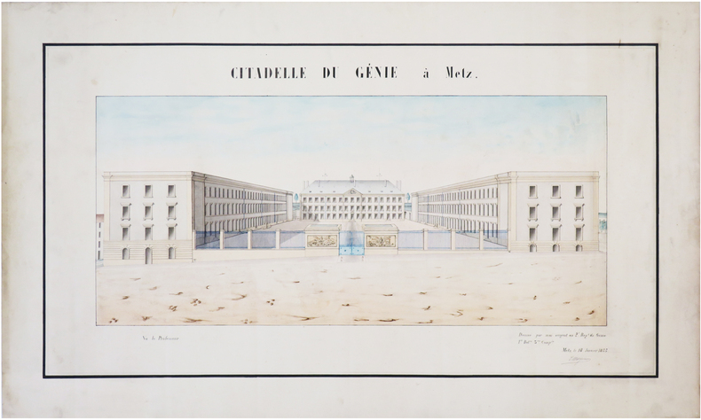
MARGUEROY (?).
[MOSELLE] Citadelle du Génie à Metz.
18 janvier 1855. 32 x 60 cm.
书商的参考编号 : LBW-7455
|
|
|
Mari Sandoz/Brian Forsyth Illus. and maps
Love Song to the Plains
Harper & Brothers Publishers. Used - Good. 1961 Hardcover First Edition . Shows some signs of wear and may have some markings on the inside. Harper & Brothers Publishers hardcover
书商的参考编号 : GRP63696126
|
|
|
Mariano VOLPI
MAGIE ET TOURS DE CARTES
Un ouvrage de 160 pages, format 110 x 175 mm, broché couverture couleurs, publié en 1989, Editions Sogemo, collection "Guides Pratiques Total", bon état
书商的参考编号 : LFA-126746280
|
|
|
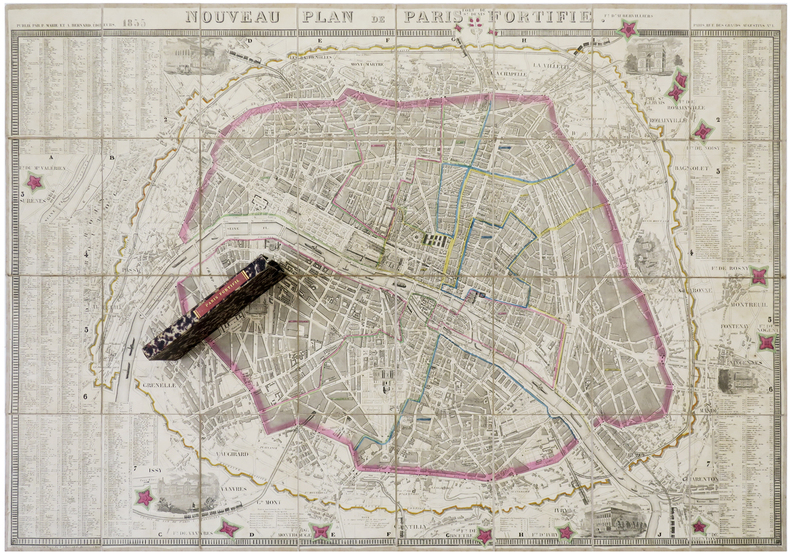
MARIE (P.) & BERNARD (A.).
Nouveau plan de Paris fortifié.
Paris, P. Marie et A. Bernard, 1855. En 32 sections montées sur toile et pliées, formant un plan de 610 x 888 mm ; sous étui de papier marbré avec titre en lettres dorées au dos.
书商的参考编号 : LBW-6276
|
|
|
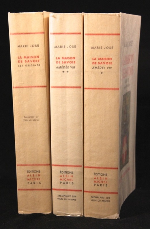
MARIE JOSE; CROCE Benedetto (préf.):
La maison de Savoie. Les origines. Le Comte Vert. Le Comte Rouge. Amédée VIII, le duc qui devint Pape.
Paris, Albin Michel, 1956 et 1962. 3 vol. in-8 brochés de 425-[4], 446-[2] et 373-[2] p., couvertures illustrées couleur. En parfait état, c'est à dire comme neufs, non coupés.
书商的参考编号 : 5921
|
|
|
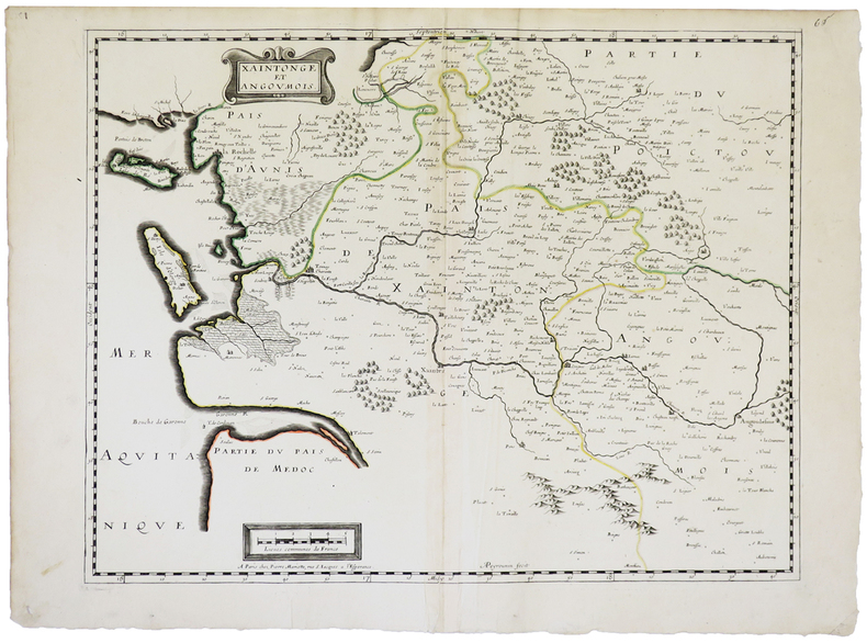
MARIETTE (Pierre).
[SAINTONGE] Xaintonge et Angoumois.
Paris, Pierre Mariette, [1650]. 382 x 490 mm.
书商的参考编号 : LBW-2264
|
|
|
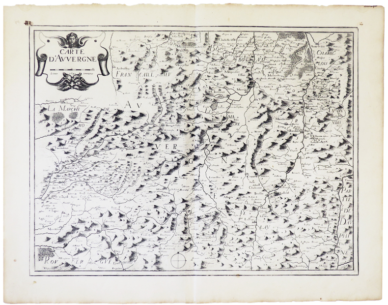
MARIETTE (Pierre).
Carte d'Auvergne.
Paris, Pierre Mariette, 1643 [1650]. 367 x 484 mm.
书商的参考编号 : LBW-977
|
|
|
MARIETTE (Pierre).
Grèce moderne ou partie méridionale de la Turquie en l'Europe.
Paris, P. Mariette, [circa 1650]. 400 x 509 mm.
书商的参考编号 : LBW0394a

|
|
|
MARIN John
Etudes artistiques - Beaux-arts Art appliqué
Editions de l'Art décoratif 0 In-4 Demi-reliure à coins
书商的参考编号 : 014334
|
|
|
MARIN KARMITZ
"Carte Postale du film "" Petits Freères "", de Jacques Doillon avec Stéphanie Touly, Ilies Sefraoui, Mustapha Goumane, Rachid Mansouri."
LIBRAIRIE DU GLORIT. Non daté. In-12. Broché. Bon état, Couv. convenable, Dos satisfaisant, Intérieur frais. Une carte postale, vierge, illustrée en couleurs. 14.5 x 10 cm.. . . . Classification : 220-Cartes Postales Publicitaires
书商的参考编号 : RO80093904
|
|
|
Marinache V. Maps by
Romania; a Guidebook
Bucharest Meridiane Pub. House 1967. First Edition. An exceptional copy; fine in an equally fine dw. Complete with slightly worn stiff-card slipcase. Particularly and surprisingly well-preserved; tight bright clean and especially sharp-cornered. Literally as new. ; 491 pages; Description: 491 p. Illus. part col. col. Maps. 18 cm. Subjects: Romania --Guidebooks. Bucharest, Meridiane Pub. House unknown
书商的参考编号 : 88199

|
|
|
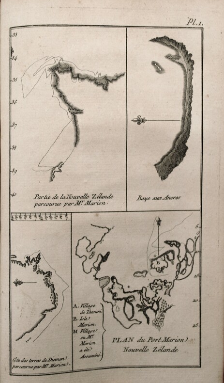
MARION DU FRESNE , CROZET (Julien) , ROCHON (Abbé Alexis-Marie de, rédacteur).
Nouveau voyage à la mer du sud commencé sous les ordres de M. MARION, chevalier de l'Ordre Royal & militaire de S. Louis, capitaine de brûlot ; & achevé, après la mort de cet Officier, sous ceux de M. le Chevalier Duclesmeur, garde de la Marine. Cette relation a été rédigée d'après les Plans & Journaux de M. CROZET. On a joint à ce voyage un Extrait de celui de M. De Surville dans les mêmes Parages.
A Paris, Chez Barrois l'aîné, 1783. In 8° ( 195x120) Relié plein veau époque, pièce de titre rouge, dos lisse orné , tranches rouges . VIII, 290 pp, illustré de 2 cartes dont 1 repliée h.-t. et 5 pl. h.-t. , Complet du dernier feuillet, extrait du privilège à la date du 11 mai 1782, établi par Condorcet secrétaire de l'Académie des sciences.
书商的参考编号 : PHO-455
|
|
|
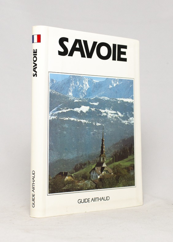
MARIOTTE Ruth et Jean-Yves:
Savoie.
Paris, Les éditions Arthaud, 1991. In-12 de 278-[4] pages, couverture photographique imprimée en couleurs.
书商的参考编号 : 16664
|
|
|
Marjatta Bell; Marjatta Hietala
Helsinki, the Innovative City
No marks or inscriptions. No creasing to covers or to spine. A lovely clean very tight copy with bright unmarked boards and no bumping to corners. Dust jacket not price clipped or marked or torn or creased with very minor traces of storage 447pp. History, culture, development and the society of Helsinki, Finland's Capital City. 'Helsinki - The Innovative City' describes how the capital of Finland was developed into a handsome, sophisticated city. It tells the story of how its innovative citizens and its determined City Council turned a small rocky seaport into a European city of distinction with fine public services and continuing links with the surrounding nature.
|
|
|
Mark A.; star maps by Wil Tirion Garlick
The Illustrated Atlas of the Universe
2006-07-04. New. Ships with Tracking Number! INTERNATIONAL WORLDWIDE Shipping available. May be re-issue. Buy with confidence excellent customer service! unknown
书商的参考编号 : 1740893778n ???????? : 1740893778 9781740893770

|
|
|
Mark A.; star maps by Wil Tirion Garlick
The Illustrated Atlas of the Universe
2006-07-04. Good. Ships with Tracking Number! INTERNATIONAL WORLDWIDE Shipping available. May not contain Access Codes or Supplements. May be re-issue. May be ex-library. Shipping & Handling by region. Buy with confidence excellent customer service! unknown
书商的参考编号 : 1740893778q ???????? : 1740893778 9781740893770

|
|
|
Mark Brandenburg
Brandenburgum Marchionatus. Cum Ducatibus Pomeraniae et Mekelenburgi. Original-Kupferstich von Matthäus Merian, mit Titelkartusche u. Meilenzeiger.
(Frankfurt a. M.), M. Merian, [ca. 1652]. Mit Mittelfalz. Darstellung: 36 x 27,5 cm; Blatt: 39,5 x 34 cm. Gerahmt. Unter braunem Passepartout.
书商的参考编号 : 86713

|
|
|
Markidou, Loula and Caudery, Tim
Cyprus : A Comprehensive Guidebook
No marks or inscriptions. No creasing to covers, light crease down spine. A clean crisp very tight copy with bright covers and no bumping to corners. 113pp. The culture and history of the island in a gazetteer style, with superb colour photographs.

|
|
|
Markus Hauser/ Gecko Maps
Tajikistan Northern
Swiss Cooperation Office Tajikistan 2009. Map. New. 1st edition. 2 pages. 7.00x4.10x0.40 inches. Swiss Cooperation Office Tajikistan unknown
书商的参考编号 : __3906593452 ???????? : 3906593452 9783906593456
|
|
|
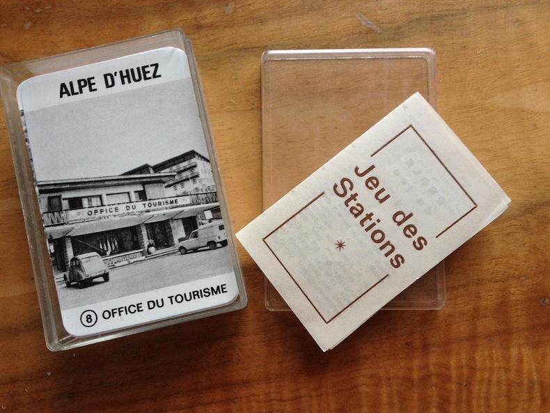
MAROBER Editeur. ( JEU de cartes ) Jeux Olympiques de 1968.
JEU DES STATIONS.
1969 1969 Marober . France. Editeur ( juin 1969 ). Jeu de 64 cartes illustrées de photographies en noir et blanc des stations olympiques de 1968. ( Grenoble; Alpe d'Huez; Les Deux Alpes; Chamrousse ; Autrans; Villard de Lans; Val d'Isère; Pralognan ) . chaque station avec 8 vues différentes. bien complet de la règle du jeu . parfait état intérieur. édition simple ne comportant que les cartes , dans une boîte plastique transparente avec règle du jeu.
书商的参考编号 : 2413
|
|
|
MAROC. . .
Carte en couleurs extraite de l'Atlas Universel. Sans date.
1 feuille 50x40 cm. Pli central.
|
|
|
Marr DSB./Howick Baker JD. maps/Bromet Geoffrey R. foreword D. S. J. D.
A History of 208 Squadron
Southend on Sea: Eden Fisher Ltd. printed by 1966. 1st printing. VG. vi 115 p. photos maps appendices large 8vo paperback; Eden Fisher Ltd. (printed by) paperback
书商的参考编号 : 51524

|
|
|
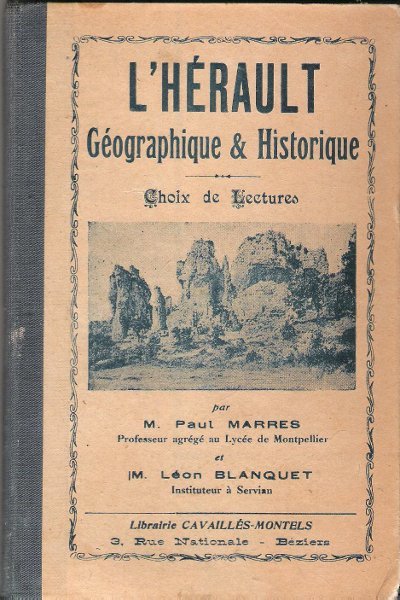
MARRES Paul , BLANQUET Léon
L'HERAULT Géographique & Historique : Choix De Lectures . Complet De ses Pages Dépliantes En Fin D'ouvrage
Béziers Librairie Cavaillès-Montels 0 In 16 Ancien livre d'école avec son dos en percaline . Complet de sa carte géologique dépliante et de ses cartes : historique et tableaux chronologiques . Illustré de photographies en noir et blanc . Cartes et plans . Régionalisme Languedoc . - 284 p. , 400 gr.
书商的参考编号 : 021706
|
|
|
MARRES Paul , BLANQUET Léon
L'HERAULT Géographique & Historique : Choix De Lectures . Complet De ses Pages Dépliantes En Fin D'ouvrage
Ancien livre d'école avec son dos en percaline . Complet de sa carte géologique dépliante et de ses cartes : historique et tableaux chronologiques . Illustré de photographies en noir et blanc . Cartes et plans . Régionalisme Languedoc . - 284 p. , 400 gr.

|
|
|
MARSEILLE- CARPENTRAS
Carte touristique au 1/100 000e.
Une feuille 89x121 cm.
|
|
|
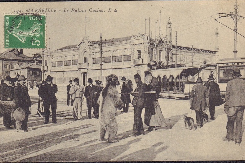
MARSEILLE.-
Montreur d'ours devant le Palace Casino.-
Marseille. L. Vers 1910. Carte postale en noir et blanc, très animée, montreur d'ours accompagné de plusieurs personnes dont une femme et un homme portant un tambourin devant un tramway et le casino. Timbre semeuse dans l'angle supérieur gauche, non gênant. Bel exemplaire. Photo sur demande.
书商的参考编号 : ORD-17579
|
|
|
Marshall SLA./Lennox Mark maps S. L.
Crimsoned Prairie: The Wars Between the United States and the Plains Indians During the Winning of the West
NY: Charles Scribner's Sons 1972. 1st printing. VG/VG dust jacket very light bumping to top corners price clipped dust jacket. xviii 256 p. photos maps index 8vo; Charles Scribner's Sons hardcover
书商的参考编号 : 72308 ???????? : 0684130890 9780684130897

|
|
|
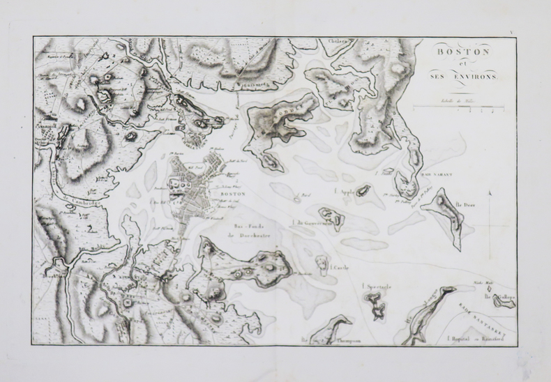
MARSHALL (John).
[GUERRE d'INDÉPENDANCE] Boston et ses environs.
[1807].203 x 320 mm.
书商的参考编号 : LBW-4673
|
|
|
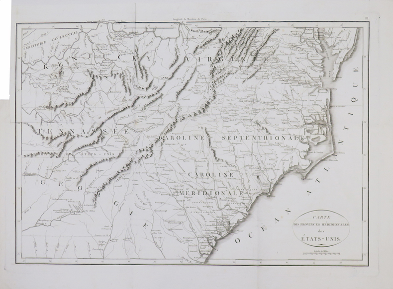
MARSHALL (John).
[GUERRE d'INDÉPENDANCE] Carte des provinces méridionales des États-Unis.
[1807]. 347 x 499 mm.
书商的参考编号 : LBW-4667
|
|
|
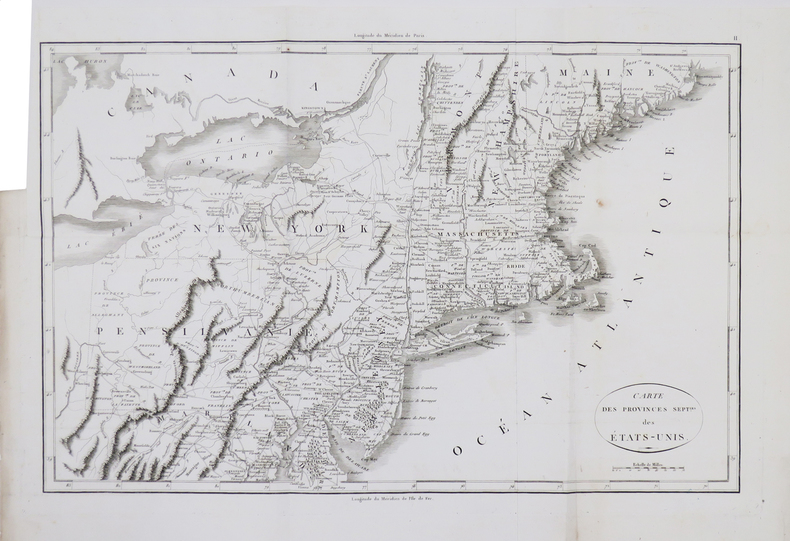
MARSHALL (John).
[GUERRE d'INDÉPENDANCE] Carte des provinces sept.les des États-Unis.
[1807]. 332 x 501 mm.
书商的参考编号 : LBW-4668
|
|
|
MARSHALL (John).
[GUERRE d'INDÉPENDANCE] Mont-Vernon, habitation du Général Washington, située dans la Virginie.
[1807]. 156 x 196 mm.
书商的参考编号 : LBW-4674

|
|
|
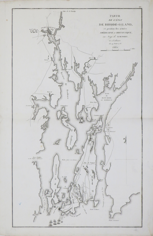
MARSHALL (John).
[GUERRE d'INDÉPENDANCE] Partie de l'état de Rhode-Island, et position des armées américaine et britannique, au siège de Newport, et à l'affaire du 29 août 1778.
[1807]. 423 x 250 mm.
书商的参考编号 : LBW-4670
|
|
|
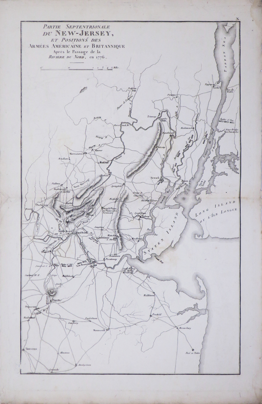
MARSHALL (John).
[GUERRE d'INDÉPENDANCE] Partie septentrionale du New-Jersey, et positions des armées américaine et britannique après le passage de la Rivière du Nord, en 1776.
[1807]. 400 x 249 mm.
书商的参考编号 : LBW-4669
|
|
 ?????????
 ?????PDF???
 RSS feed


