|
MOLL (Herman).
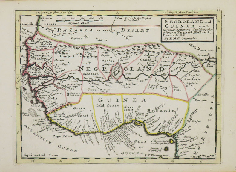
[AFRIQUE de l'OUEST] Negroland and Guinea with the European settlement, explaining what belongs to England, Holland, Denmark &c.
[Londres], Thomas and John Bowles, [circa 1736]. 204 x 275 mm.
書籍販売業者の参照番号
: LBW-3565
|
|
|
MOLL (Herman).
[BERMUDES] The Island of Bermudos divided into its tribes, with the castles, forts &c.
Londres, Thomas and John Bowles, [circa 1736]. 203 x 270 mm.
書籍販売業者の参照番号
: LBW-3559

|
|
|
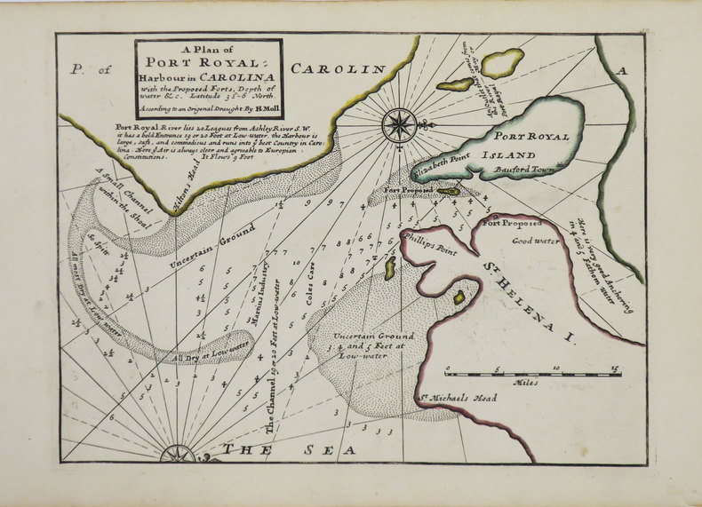
MOLL (Herman).
[CAROLINE du SUD] A Plan of Port Royal harbour in Carolina with the proposed forts, depth of water &c.
Londres, Thomas and John Bowles, [circa 1736]. 200 x 270 mm.
書籍販売業者の参照番号
: LBW-3563
|
|
|
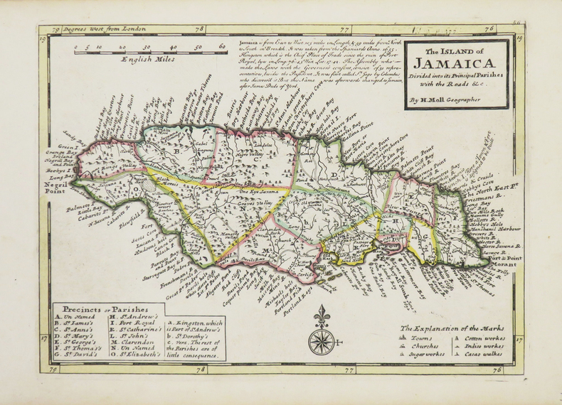
MOLL (Herman).
[JAMAÏQUE] The Island of Jamaica.
Londres, Thomas and John Bowles, [circa 1736]. 200 x 275 mm.
書籍販売業者の参照番号
: LBW-3541
|
|
|
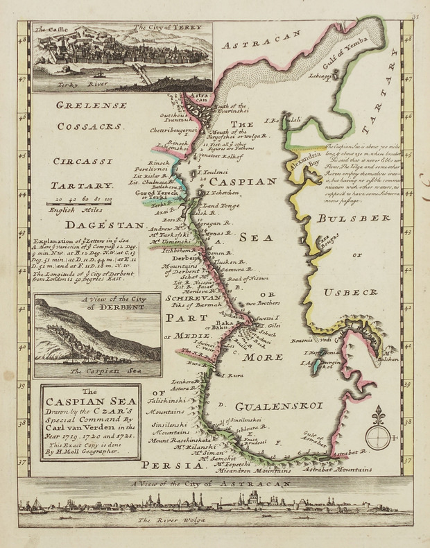
MOLL (Herman).
[MER CASPIENNE] The Caspian sea drawn by the Czar's special command by Carl van Verden in the year 1719, 1720 and 1721.
[Londres, Thomas and John Bowles, circa 1736]. 262 x 205 mm.
書籍販売業者の参照番号
: LBW-2913
|
|
|
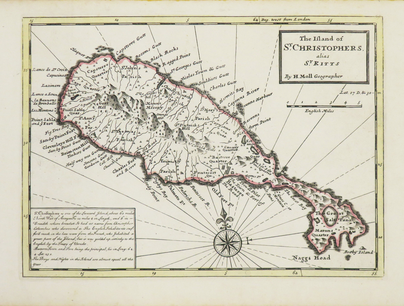
MOLL (Herman).
[SAINT KITTS] The Island of St. Christophers alias St. Kitts.
Londres, Thomas and John Bowles, [circa 1736]. 199 x 274 mm.
書籍販売業者の参照番号
: LBW-3534
|
|
|
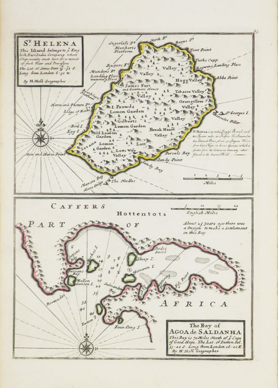
MOLL (Herman).
[SAINTE-HELENE] St. Helena - The bay of Agoa de Saldanha.
[Londres], Thomas and John Bowles, [circa 1736]. 275 x 203 mm.
書籍販売業者の参照番号
: LBW-3543
|
|
|
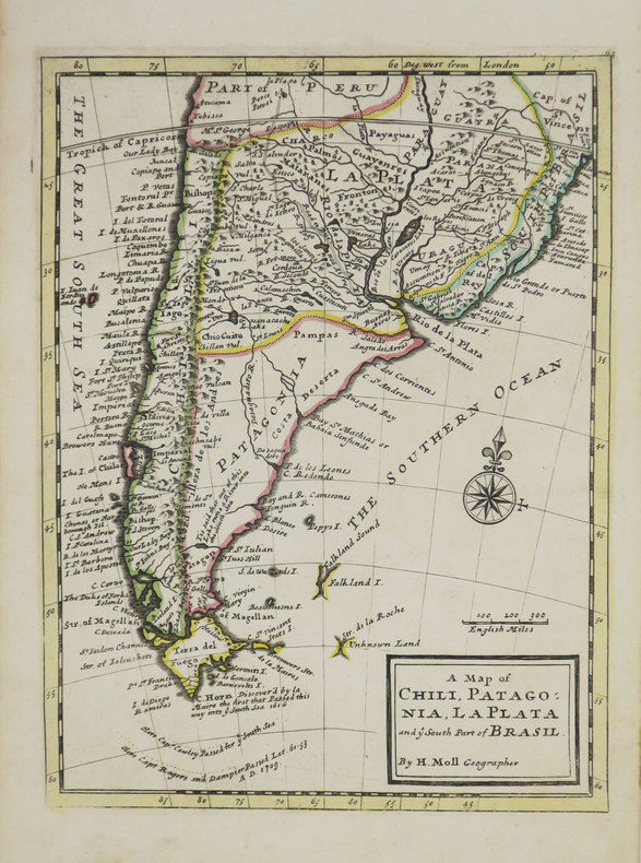
MOLL (Herman).
A Map of Chili, Patagonia, La Plata and ye south part of Brasil.
[Londres], Thomas and John Bowles, [circa 1736]. 276 x 206 mm.
書籍販売業者の参照番号
: LBW-3519
|
|
|
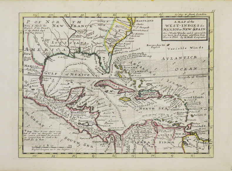
MOLL (Herman).
A Map of the West-Indies &c Mexico or New Spain.
Londres, Thomas and John Bowles, [circa 1736]. 198 x 264 mm.
書籍販売業者の参照番号
: LBW-3544
|
|
|
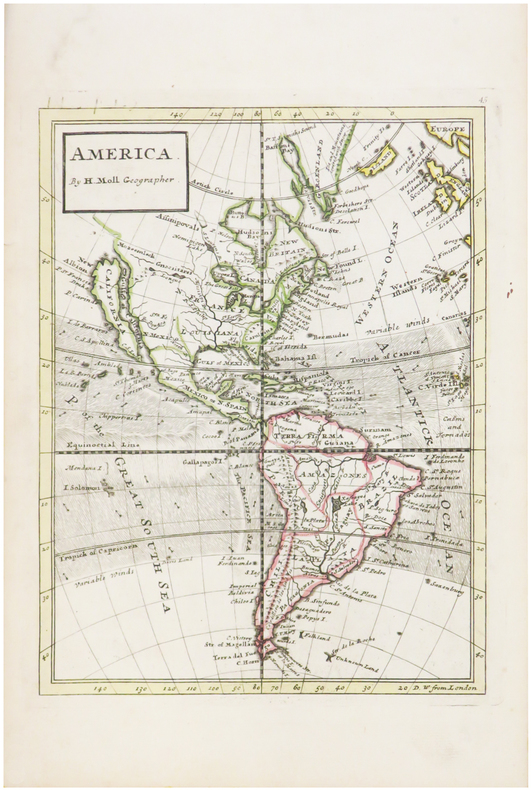
MOLL (Herman).
America.
[Londres, 1739]. 263 x 198 mm.
書籍販売業者の参照番号
: LBW-482
|
|
|
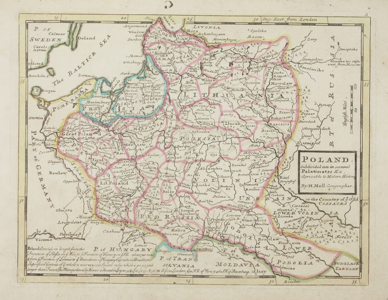
MOLL (Herman).
Poland subdivided into its several palatinates &c.
Londres, Thomas and John Bowles, [circa 1736]. 199 x 260 mm.
書籍販売業者の参照番号
: LBW-2903
|
|
|
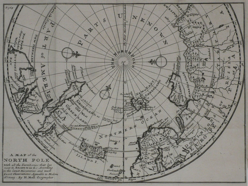
MOLL (Herman);
A Map of the North pole with all the territories that lye near it.
Londres 1739 201 x 271 mm.
書籍販売業者の参照番号
: LBW-1194
|
|
|
Molony, Eileen (editor)
Portraits of Rivers
Ex Boots library book with marks only to covers, none to contents. No creasing to covers or to spine. A very clean very tight copy with maroon boards and no bumping to corners. 139pp. With features on eleven British rivers by eleven well-known authors, including the Itchen by Brian Vesey-Fitzgerald, the Severn by Brian Waters and the Thames by Laurie Lee.

|
|
|
Mombert, J. I.
AN AUTHENTIC HISTORY OF LANCASTER COUNTY, IN THE STATE OF PENNSYLVANIA.
pp. vii, 617, 175 + Plus large folding frontis map, lithographed and engraved illustrations and several maps, one in color. Folding frontis map has old tape repair. Inked ownership of A. C. Kepler, July 1869. His initials on title page. Text very slightly browned. Large 8vo. Original full leather binding. Boards detached with some loss on spine. Hardbound. Howes M 720. PA 45 rear
|
|
|
MONALDINI Venanzio (attivo 1765 - 1829 circa)
Nuova Pianta di Roma Moderna estratta dalla grande del Nolli corretta ed accresciuta de' nomi delle contrate indicati al lor
Pianta della città di Roma basata sulla mappa di Giovanni Battista Nolli (1692-1756). Incisione di Pietro Ruga. Con una legenda (I - XIV), scala e titolo "Nuova pianta di Roma moderna estratta dalla grande del Nolli: nell'angolo in basso a destra, corretta ed accresciuta de 'nomi delle contrade indicate al loro rispettivo sito".Include 4 piani inserti del Pantheon, della basilica di San Paolo, del mausoleo di Santa Costanza e della chiesa di San Lorenzo.Si tratta della prima edizione della pianta che il Ruga disegnò ed incise per l'editore Venanzio Monaldini, il cui successo e diffusione è testimoniato dal fatto che venne ristampata in successive sei edizioni fino al 1843. Sul lato destro sono raffigurate le piante del Mausoleo di Santa Costanza, Basilica di San Paolo e Panthon; in alto a destra San Lorenzo fuori le mura. IN basso a destra, sopra al titolo, è inciso l'elenco dei 14 Rioni. Nella pianta, assai dettagliata, da notare l'emiciclo di Piazza del Popolo realizzato solo per metà.Incisione in rame, in 20 sezioni posate su lino e più volte ripiegate, racchiuse in astuccio in cartonato coevo. Ottime condizioni. Town plan of Rome based on map by Giovanni Battista Nolli, ( fl. 1692-1756). Engraved by Pietro Ruga. With a key (I - XIV), scale and text "Nuova pianta di Roma moderna estratta dalla grande del Nolli : corretta ed accresciuta de' nomi delle contrade indicati al loro rispettivo sito", in lower right corner.Includes 4 inset plans of the Pantheon, St. Paul's basilica, the mausoleum of St. Costanza and the church of San Lorenzo.Dissected in 20 sections and laid on linen, as issued. Fine condition.A fine and rare 1843 case format map of Rome, Italy by Venanzio Monaldini. This extraordinary map of Rome heavily references, with various updates and revisions, the seminal 1734 map of Rome by Giovanni Battista Nolli. Nolli’s map was the first modern map of Rome and basis of almost all subsequent maps of Rome until approximately 1870, when Rome became the capitol of Italy and more modern plans were issued. Depicts the city in extraordinary detail labeling all streets, ferry crossings, bridges, parks, and historic buildings. Surrounded by plans of important buildings including the Mausoleum of Saint Constance, the Basilica of St. Paul, a layout of the Pantheon, and the floor of the Church of Saint Lorenzo. This map was designed with the traveler in mind and thus bisected and backed with linen for easy folding. Comes with original slipcase. Most likely engraved by Pietro Ruga, a prominent Rome based engraver best known for his architectural plans and views. Published from Venanzio Monaldini’s bookshop on 79 Piaza di Spagna, Rome, Italy. Marigliani, Le Piante di Roma nelle collezioni private, p. 307, n. 233. Scaccia Scarafoni p. 258.

|
|
|
MONALDINI Venanzio (attivo 1765 - 1829 circa)
Pianta della Citta di Roma con la indicazione di tutte le Antichita e in Nuovi Abbellimenti
Incisione in rame, montata su tela coeva e divisa in 32 stacchi. Riporta in basso la nota “Publicata spese di Venanzio Monaldini Libraio e Cartolaro in Piaz.ª di Spagna Nº19 an.º 1824”. Molto ben conservata. La mappa raffigura la città entro la cinta delle mura, come incisa su una lastra di pietra. Sui lati la pianta è arricchita da sono16 piccole vedute raffiguranti alcuni tra i maggiori monumenti: Basilica di S. Pietro; Basilica di S.M. Maggiore; Pantheon di Agrippa; Foro romano; Basilica di S. Giovanni in Laterano; Basilica di S. Paolo; Campidoglio; Anfiteatro Flavio; Piramide di C. Cestio; Foro Trajano; Monte Cavallo. Ai lati della pianta vi è poi un lungo elenco di toponimi.Prima edizione della più nota e migliore pianta di Pietro Ruga, pubblicata da Venanzio Monaldini. La città è raffigurata come se fosse incisa su una grande lastra di pietra affissa a parete mediante grappe metalliche, riprendendo in questo un'invenzione del Piranesi (la pianta inserita nell'opera Le Antichità Romane del 1756). Piazza del Popolo è rappresentata con i due emicicli appena completati (1823). Secondo Scaccia Scarafoni la pianta ha una scla di 1:7000. First edition of the "marble map" of Rome by Pietro Ruga.Copper engraving, mounted on coeval canvas and divided into 32 pieces.Below is the note ublicata spese di Venanzio Monaldini Libraio e Cartolaro in Piaz.ª di Spagna Nº19 an.º 1824".Very well preserved. The map depicts the city within the walls, as carved on a stone. On the sides the plant is enriched by 16 small views representing some of the major monuments: Basilica di S. Pietro; Basilica di S.M. Maggiore; Pantheon di Agrippa; Foro romano; Basilica di S. Giovanni in Laterano; Basilica di S. Paolo; Campidoglio; Anfiteatro Flavio; Piramide di C. Cestio; Foro Trajano; Monte Cavallo. On the sides of the plant there is also a long list of toponyms. Marigliani, Le Piante di Roma nelle collezioni private, p. 319, n. 249; Frutaz 188, Scaccia Scarafoni n. 264.

|
|
|
MONALDINI Venanzio (attivo 1765 - 1829 circa)
Vestigie di Roma Antica
Pianta a proiezione verticale, orografica, orientata con il nord in alto. Ristampa della pianta archeologica pubblicata nel 1819; nel cartiglio in basso a sinistra si legge, al luogo della dedica a papa Pio VII: "Pianta delle Vestigia di Roma secondo le osservazioni di Antonio de Romanis, arch. e socio dell' accad. di archeol. e di Antonio Nibby profess. di archeologia nell Vniv. di Roma e socio della stessa accademia dallo stesso corretta ed ampliata secondo le vltime scoperte. Data in luce da Venanzio Monaldini Libraio l'anno MDCCCXXVI".Pianta disegnata dagli archeologi Antonio De Romanis e Antonio Nibby, incisa da Giovanni Acquaroni per l'editore e committente Venanzio Monaldini.Come sottolinea Scaccia Scarafoni si tratta di un primo tentativo di riliebo scientifico dei soli ruderi allora conservati; intorno alla pianta sono diseganti i frammenti della Forma Urbis Severiana.Antonio de Romanis è un celebre architetto il cui nome è legato soprattutto al volume "Le antiche camere Esquiline dette comunemente delle Terme di Tito" del 1822, di fatto la prima relazione scientifica sugli ambienti della domus aurea in luce dopo gli scavi napoleonici.Antonio Nibby (Roma, 14 aprile 1792 – Roma, 29 dicembre 1839) è stato uno storico, archeologo e topografo italiano. Delle suddette discipline pose rigorosi fondamenti scientifici basandosi sull'analisi delle fonti classiche e medievali, lo studio dei monumenti e l'indagine diretta sul terreno. Fu studioso di topografia soprattutto di Roma antica e della Campagna Romana.Acquaforte, stampata su un grande foglio di carta coeva, con margini, in perfetto stato di conservazione. A vertical projection map, orographic, oriented with the north at the top. Reprint of the archaeological map published in 1819; in the cartouche at the bottom left we read, instead of the dedication to Pope Pius VII: "Pianta delle Vestigia di Roma secondo le osservazioni di Antonio de Romanis, arch. e socio dell' accad. di archeol. e di Antonio Nibby profess. di archeologia nell Vniv. di Roma e socio della stessa accademia dallo stesso corretta ed ampliata secondo le vltime scoperte. Data in luce da Venanzio Monaldini Libraio l'anno MDCCCXXVI".The map was drawn by the archaeologists Antonio De Romanis and Antonio Nibby, engraved by Giovanni Acquaroni for the publisher and customer Venanzio Monaldini.As Scaccia Scarafoni points out, this is a first attempt at scientific re-enactment of the only ruins then preserved; around the map are fragments of the Forma Urbis Severiana.Antonio de Romanis is a famous architect whose name is mainly linked to the volume "Le antiche camere Esquiline dette comunemente delle Terme di Tito" of 1822, in fact the first scientific report on the environments of the Domus Aurea after the Napoleonic excavations.Antonio Nibby (Rome, 14 April 1792 - Rome, 29 December 1839) was an Italian historian, archaeologist and topographer. He laid rigorous scientific foundations of the above mentioned disciplines based on the analysis of classical and medieval sources, the study of monuments and the direct investigation on the ground. He was a scholar of topography especially of ancient Rome and the Roman countryside.Etching, printed on a large sheet of contemporary paper, with margins, in perfect condition. Scaccia Scarafoni p. 46, n. 66.

|
|
|
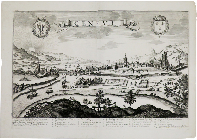
MONCORNET (Balthazar).
Genève.
[circa 1660]. 343 x 511 mm.
書籍販売業者の参照番号
: LBW0028e
|
|
|
MONDHARE (Louis Joseph) & JEAN (Pierre).
[PAVILLONS] Tableau de tous les pavillons que lon arbore sur les vaisseaux dans les quatre parties du Monde, où se trouve le pavillon de France décrété par l'Assemblée Nationale le 24 octobre 1790.
Paris, Mondhare et Jean, 1791. 592 x 866 mm.
書籍販売業者の参照番号
: LBW-5966

|
|
|
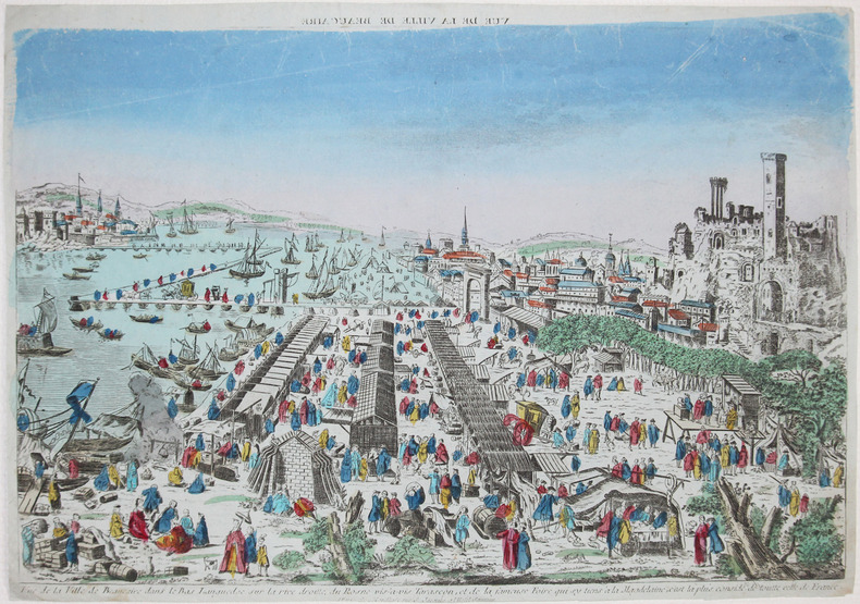
MONDHARE (Louis Joseph).
[BEAUCAIRE] Vue de la ville de Beaucaire dans le Bas Languedoc sur la rive droitte du Rosne vis-à-vis Tarascon, et de la fameuse foire qui sy tiens à la Magdelaine, c'est la plus considé.ble de toutte celle de France.
Paris, Mondhare, [circa 1790]. 284 x 408 mm.
書籍販売業者の参照番号
: LBW-2623
|
|
|
MONDHARE (Louis Joseph).
Plan de la ville et faubourgs de Paris avec tous les changements et augmentations faits et projetés, ornés des principaux édifices quelle renferme ; dédié au Roy.
Paris, Mondhare et Jean, 1786. En quatre feuilles coupées en 45 sections montées sur toile et repliées, formant un plan de 0,94 x 1,22 m.
書籍販売業者の参照番号
: LBW-7853

|
|
|
MONDINOUX (F.).-
Le bridge (Etude sur la méthode ALBARRAN & NEXON). La déclaration, le Black wood, Le jeu de la carte.
Bagneux, Editions du Cep, 1947, in 8° broché, 217 pages ; couverture illustrée (fanée) ; dessins ; des annotations et des passages soulignés au crayon de couleur.
書籍販売業者の参照番号
: 27343
|
|
|
MONGINOUX F.
Le bridge ( étude sur la méthode ALBARRAN et NEXON)La déclaration, le black wood, le jeu de la carte.
broché - 18x22,5 - sans date - 127 pp - éditionsdu CEPavec 2 illustrations dans le texte.
書籍販売業者の参照番号
: 1923
|
|
|
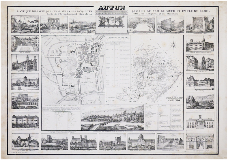
MONI (Claude).
[AUTUN] Autun. L'antique Bibracte que César, après ses conquêtes, qualifia du nom de sœur et émule de Rome. Carte de l'arrondissement, plan de la ville, ses antiquités et ses monumens.
Paris, 1834. 575 x 798 mm.
書籍販売業者の参照番号
: LBW-7189
|
|
|
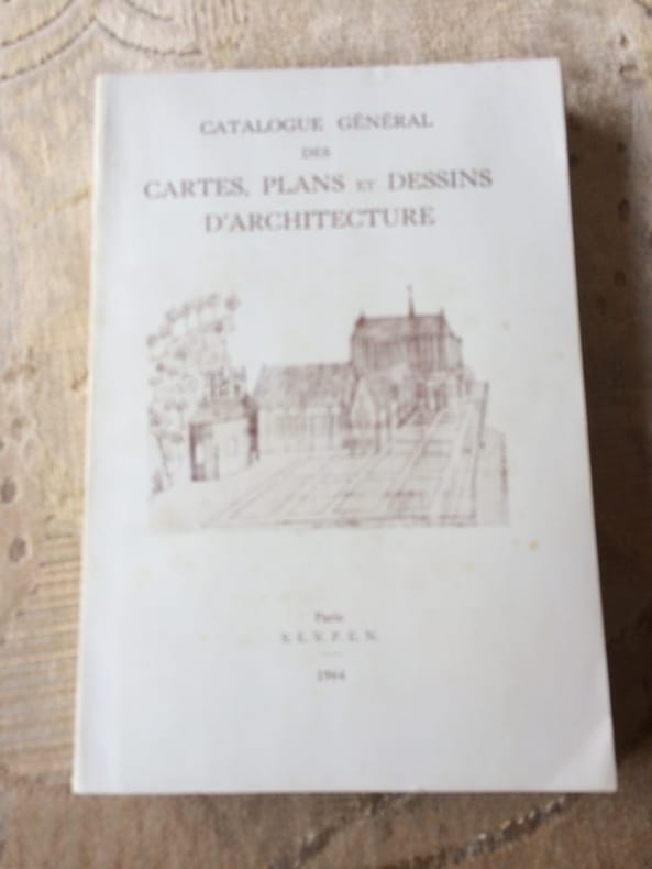
Monique HEBERT et Michel LE MOEL Conservateurs aux Archives Nationales
CATALOGUE général de s CARTES, PLANS et DESSINS D'ARCHITECTURE Tome II Série N Départements Ain à Nord
1964 Paris S.E.V.P.E.N. 1964. Ministère des Affaires Culturelles Direction des Archives de France. In 8° broché de 466 pp. illustré de 20 planches dépliantes. Menus défauts au dos, traces de pliure; Bon exemplaitre sur papier glacé.
書籍販売業者の参照番号
: 2288
|
|
|
Monk Charles
Bridge, système complet des enchères modernes
Albin Michel Broché 1970 In-8, (21x10.5 cm), broché, couverture illustrée, 276 pages, préface de José le Dentu ; plats légèrement défraîchis, pliures sur le dos, bon état. Livraison a domicile (La Poste) ou en Mondial Relay sur simple demande.
書籍販売業者の参照番号
: nf186

|
|
|
Monmarche Gaston editor; Fold out Maps Illustrator
Les Guides Bleus: Paris Versailles Saint-Germain Saint-Denis Chantilly Fontainebleau
Librairie Hachette 1934-01-01. Hardcover. Very Good. NICE CONDITION SOFTCOVER BOOK. NO WRITING OR MARKINGS IN TEXT. SIGNED BY PREVIOUS OWNER ON TITLE PAGE. ONLY LIGHT WEAR & MINIMAL FRAYING TO COVER. A CLEAN & SOLID BOOK. Librairie Hachette hardcover
書籍販売業者の参照番号
: B-1978
|
|
|
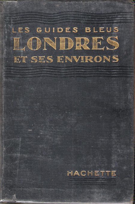
MONMARCHE Marcel et MUIRHEAD Findlay
Les Guides Bleus : LONDRES et Ses Environs . Complet De Sa Carte Dépliante et De Ses Cartes En Couleurs .
Paris Librairie Hachette 1929 In 16 Collection " Les Guides Bleus " . Excursions , nombreux plans de voyage et de villes en couleurs et noir et blanc . Une grande carte dépliante représentant Londres avant la 2° Guerre Mondiale . Index alphabérique . Les endroits et monuments visités sont entourés au crayon . Cartes et Plans .- 252 p. + plans , 400 gr.
書籍販売業者の参照番号
: 021165
|
|
|
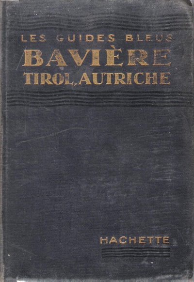
MONMARCHE Marcel , sous La Direction
Bavière , Tirol , Bains De Bohème , Salzbourg , Vienne et Les Alpes Orientales
Paris Librairie Hachette 1914 In 16 Collection " Les Guides Bleus " . Excursions , nombreux plans de voyage et de villes en couleurs et noir et blanc . Index . Avec 38 plans et 15 cartes .- 520 p. + plans , 550 gr.
書籍販売業者の参照番号
: 015270
|
|
|
MONMARCHE Marcel , sous La Direction
Bavière , Tirol , Bains De Bohème , Salzbourg , Vienne et Les Alpes Orientales
Collection " Les Guides Bleus " . Excursions , nombreux plans de voyage et de villes en couleurs et noir et blanc . Index . Avec 38 plans et 15 cartes .- 520 p. + plans , 550 gr.

|
|
|
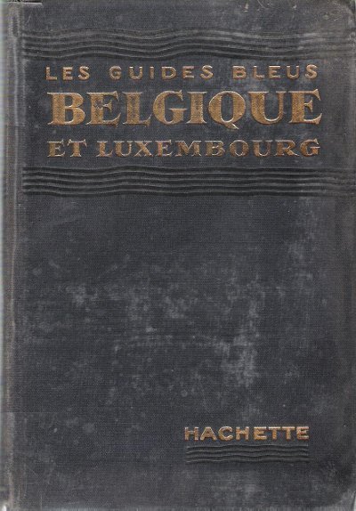
MONMARCHE Marcel , sous La Direction , TILLION Mme E. L.
Belgique et Luxembourg
Paris Librairie Hachette 1935 In 16 Collection " Les Guides Bleus " . Excursions , nombreux plans de voyage et de villes en couleurs et noir et blanc , certains dépliants . Complet de sa carte dépliante en fin d'ouvrage . Index .- 444 p. + plans , 550 gr.
書籍販売業者の参照番号
: 015271
|
|
|
MONMARCHE Marcel , sous La Direction , TILLION Mme E. L.
Belgique et Luxembourg
Collection " Les Guides Bleus " . Excursions , nombreux plans de voyage et de villes en couleurs et noir et blanc , certains dépliants . Complet de sa carte dépliante en fin d'ouvrage . Index .- 444 p. + plans , 550 gr.

|
|
|
MONMARCHE Marcel et MUIRHEAD Findlay
Les Guides Bleus : LONDRES et Ses Environs . Complet De Sa Carte Dépliante et De Ses Cartes En Couleurs .
Collection " Les Guides Bleus " . Excursions , nombreux plans de voyage et de villes en couleurs et noir et blanc . Une grande carte dépliante représentant Londres avant la 2° Guerre Mondiale . Index alphabérique . Les endroits et monuments visités sont entourés au crayon . Cartes et Plans .- 252 p. + plans , 400 gr.

|
|
|
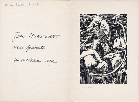
Monneret, Jean
Jean Monneret : carte de voeux pour l'année 1959 et gravure originale
1959 Carte de voeux de Jean Monneret pour l'année 1959. 27 x 18,5 cm, 2 ff., avec en page 3 une gravure sur bois originale en noir (18,5 x 12,5 cm) signée à la mine de plomb.
書籍販売業者の参照番号
: 1062
|
|
|
MONNEY Jean-Jacques
Jean-Jacques Rousseau, sa vie, son oeuvre, racontées en un siècle de cartes postales.
Slatkine 1994 Slatkine, 1994, 130 p., broché oblong, environ 15x21cm, coins des plats légèrement cornés, un tampon d'appartenance et un ex-libris contrecollé sur la page de garde, bon état pour le reste.
書籍販売業者の参照番号
: 103174
|
|
|
MONNIER (Paul).
[LA CIOTAT/CASSIS/PORT-MIOU] Plan des environs de La Ciotat, de Cassis et de Port-Miou (littoral du dép.t des Bouches du Rhône).
[Paris], Dépôt-Général de la Marine, 1843. 618 x 910 mm.
書籍販売業者の参照番号
: LBW-8255

|
|
|
MONNIER (Paul).
[MARSEILLE & SAINT-TROPEZ] Carte des côtes méridionales de France. Partie comprise entre Marseille et S.t Tropez.
[Paris], Dépôt des Cartes et Plans de la Marine, 1868-1889. 622 x 944 mm.
書籍販売業者の参照番号
: LBW-8312

|
|
|
MONNIER (Paul).
[MARSEILLE] Plan des ports de Marseille.
[Paris], Dépôt des Cartes et Plans de la Marine, 1874-1887. 925 x 620 mm.
書籍販売業者の参照番号
: LBW-8313

|
|
|
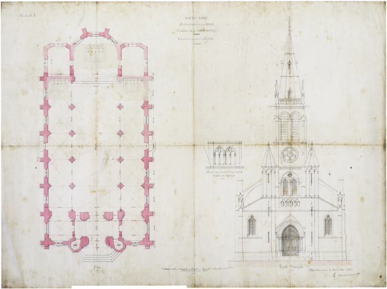
MONNIOT (Nicolas-Henri).
[HAUTE-SAÔNE] Haute-Saône. Arrondissement de Gray. Commune de Confracourt. Construction d'une église.
Châtillon-sur-Seine, 20 juillet 1858. 3 feuillets de toile à calquer de 51,4 x 67 cm.
書籍販売業者の参照番号
: LBW-7423
|
|
|
Mont ATHOS par Fabian DA COSTA.
Florilège du Mont Athos. Richement documenté (héliogravures, cartes).
Presses de la Renaissance 2005. Bel exemplaire relié, reliure souple avec rabats, gd in-8 carré, 276 pages avec table.
書籍販売業者の参照番号
: AUB-6823
|
|
|
MONT DORE. . .
Carte couleurs du Mont Dore au 1/40 000e. Sans date.
Une feuille 49x62 cm repli?e sous couverture.
|
|
|
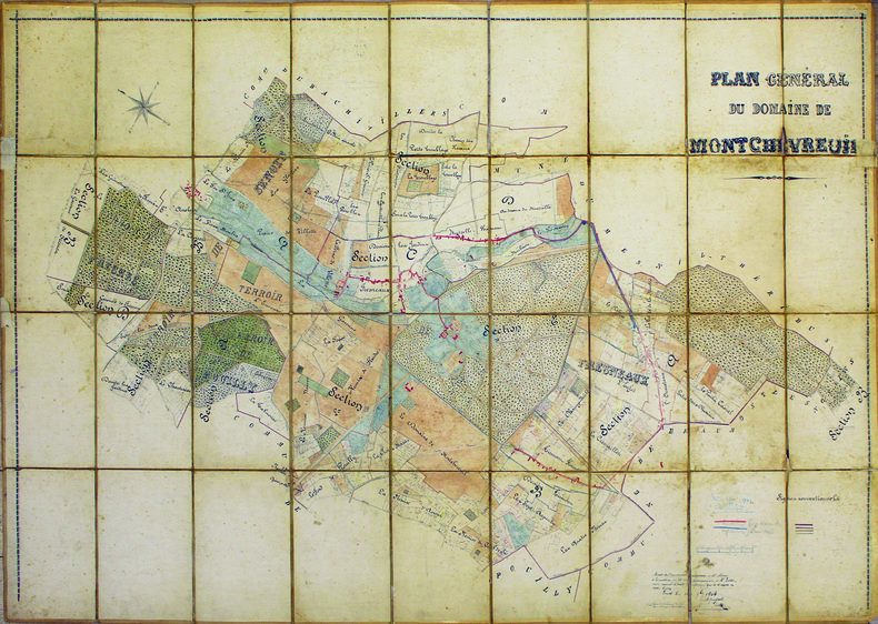
MONTCHEVREUIL. MANUSCRIT.
Plan général du domaine de Montchevreuil.
1904. En 36 sections sur toile à calquer, montées sur toile et pliées formant une carte de 1,03 x 1,55 m.
書籍販売業者の参照番号
: LBW-4133
|
|
|
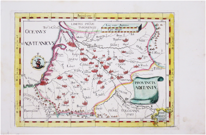
MONTECALERIO (Giovanni).
[AQUITAINE] Provincia Aquitaniæ.
[Milan, 1712]. 224 x 316 mm.
書籍販売業者の参照番号
: LBW-8132
|
|
|
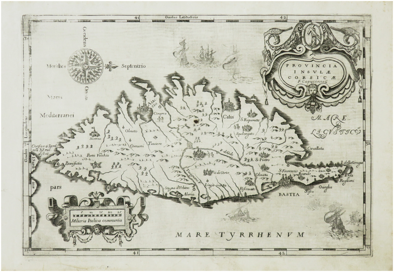
MONTECALERIO (Giovanni).
[CORSE] Provincia insulæ Corsicæ.
[Rome ou Turin, entre 1643 et 1654]. 220 x 318 mm.
書籍販売業者の参照番号
: LBW-7406
|
|
|
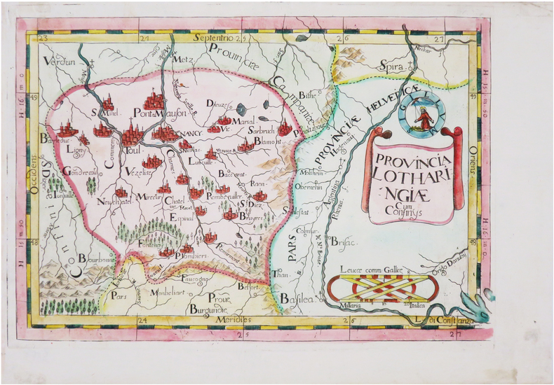
MONTECALERIO (Giovanni).
[LORRAINE] Provincia Lotharingiæ cum confinÿs.
[Milan, 1712]. 222 x 330 mm.
書籍販売業者の参照番号
: LBW-8118
|
|
|
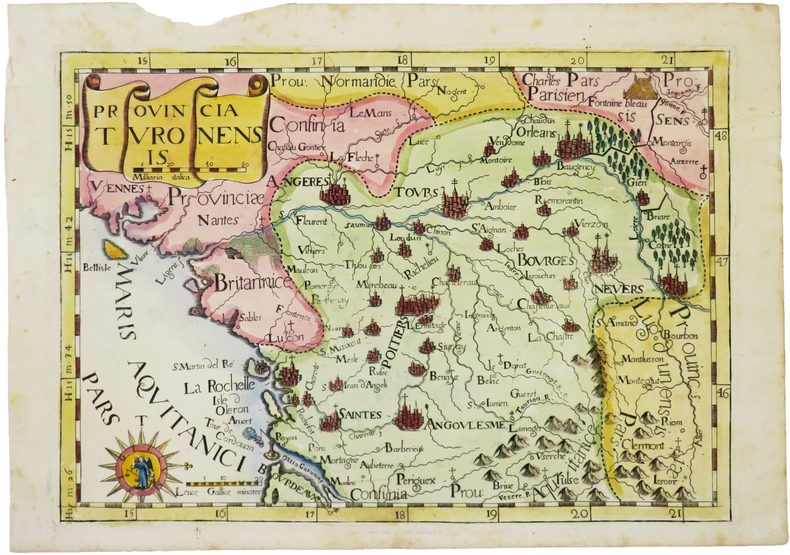
MONTECALERIO (Giovanni).
[TOURAINE] Provincia Turonensis.
[Milan, 1712]. 232 x 333 mm.
書籍販売業者の参照番号
: LBW-4951
|
|
|
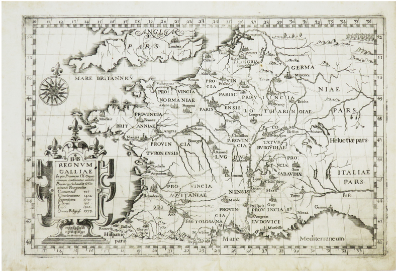
MONTECALERIO (Giovanni).
Regnum Galliæ in quo provinciæ IX Capucinorum continentur additis provincys Sabaudiæ & Comitatus Burgundiæ.
[Rome ou Turin, entre 1643 et 1654]. 213 x 325 mm.
書籍販売業者の参照番号
: LBW-7253
|
|
|
MONTESQUIEU Charles Louis de Secondat:
Oeuvres de Monsieur de Montesquieu, nouvelle édition, revue, corrigée, et considérablement augmentée par l'auteur.
A Amsterdam, et à Leipsick, Chez Arkstée et Merkus, 1758. 3 volumes in-4 de [4]-LXXXVI-527; [4]-XVI-634; [4]-648 pages, plein veau marbré, dos à nerfs ornés de filets et fleurons dorés, étiquette de titre et tomaison rouge et brune, tranches marbrées.
書籍販売業者の参照番号
: 20427
|
|
|
MONTESQUIEU Charles Louis de Secondat:
Oeuvres: De l'esprit des loix. Considérations sur les causes de la grandeur des romains, et de leur décadence. Lettres Persannes.
Londres 1757, Paris, Huart, 1755 et Cologne, Pierre Marteau, 1754. 6 volumes in-12 reliés en plein veau moucheté brun, dos à nerfs ornés de filets et fleurons dorés, pièce de titre en maroquin rouge, de tomaison en maroquin vert olive, tranches jaspées bleu.
書籍販売業者の参照番号
: 21001

|
|
|
Montgomerie Captain T. G.; et al
INDIAN ATLAS Sheet No. 73 Scale 4 Miles= 1 inch. Parts of Districts Amraoti & Wim Indur & Sirpur Tandur Wardha Bandara Chanda Nagpur.
Bombay: John Walker Thacker & Co. ltd 1903. An original large antique engraved map Part of the Indian Atlas series first dated 1868 John Walker then 1875 Secretary of State for India but with a later date of 1904; with hand-colouring in outline boundaries. Dissected into 18 parts and mounted on linen 680mm x 1035mm. Marbled paper outer panels with Thacker and Co. label. Condition is very good with a little wear only a couple of very small holes at corner folds affecting linen only. An impressive map. Soft Cover. Very Good. John Walker (Thacker & Co. ltd) Paperback
書籍販売業者の参照番号
: 017017

|
|
 検索結果のメールを受信する
 PDFファイルの検索結果をダウンロード
 RSSフィード


