|
(André Pazdzerski).
Dessin: "Couleur Ardèche" (ferme au toit de genéts au pied du Gerbier de Jonc).
Ucel, chez l'artiste, 1977, 1 carte postale en couleurs de 10 x 15 cm, illustré par le peintre André Pazdzerski, avec un envoi autographe, signé de cet artiste.
Referentie van de boekhandelaar : 18419
|
|
|
(carnet de cartes postales détachables).
CHÂTEAU DE MONTROTTIER.
Annecy, Académie Florimontane, s.d. (vers 1920), 1 broché. Carnet oblong de 10 cartes postales bistres (sur 12 annoncées) de 14 x 9 cm ;
Referentie van de boekhandelaar : 18076
|
|
|
(Carnet de cartes postales détachables).
EXPOSITION COLONIALE. Marseille 1922.
s.l., s.n., 1922, 1 agraphé, sans couverture. Carnet oblong de 20 cartes postales détachables de 16 cm x 9 cm, légére mouillure sur la dernière carte postale ;
Referentie van de boekhandelaar : 19082
|
|
|
(carte postale).
Château de Ventadour.
Meyras, Association de Sauvgarde du château-fort de Ventadour, s.d. (années 70), 1 carte postale en couleurs de 15 x 11 cm, vue aérienne, face est.
Referentie van de boekhandelaar : 18516
|
|
|
(carte postale).
Château de Ventadour.
Meyras, Association de Sauvgarde du château-fort de Ventadour, s.d. (années 70), 1 carte postale en couleurs de 15 x 11 cm, vue aérienne, face nord.
Referentie van de boekhandelaar : 18517
|
|
|
(carte postale).
Château de Ventadour.
Meyras, Association de Sauvgarde du château-fort de Ventadour, s.d. (années 70), 1 carte postale en couleurs de 15 x 11 cm, vue de l'intérieur du château.
Referentie van de boekhandelaar : 18960
|
|
|
(carte postale).
Château de Ventadour.
Meyras, Association de Sauvgarde du château-fort de Ventadour, s.d. (années 70), 1 carte postale en couleurs de 15 x 11 cm, vue de la face ouest.
Referentie van de boekhandelaar : 18961
|
|
|
(Carte postale).
LE CHATEAU DE BOULOGNE au XVe siècle (propriété du marquis de Lestrange).D'aprés un dessin de Gagne (vue générale du château , prise en vue aérienne).
Saint-Etienne de Boulogne, cliché Prinsac, collection "l'Ardèche Pittoresque", s.d. (vers 1910), 1 carte postale de 14 x 9cm, 2 petites taches de rousseurs ;
Referentie van de boekhandelaar : 17271
|
|
|
(Carte postale).
Portrait photo de l'abbé Prat, curé à St-Thomé (Ardèche).
Tournon, photo J. Taffala, s.d. (vers 1942), 1 Carte postale de 9 x 14 cm, texte autographe, signé de l'abbé A. Prat au verso.
Referentie van de boekhandelaar : 17845
|
|
|
(cartes postales).
Porcelain from Jingdezhen.
Chine, XXème, 1 sous pochette illustrée, texte en chinois et en anglais à l'intérieur de la pochette. 11 cartes postales en couleurs de 10 x 15 cm ;
Referentie van de boekhandelaar : 17960
|
|
|
(cartes à jouer)
DOMINOS-CARTES
1857 Jeu de dominos-cartes célébrant l'histoire du Premier et du Second Empire jusqu'à la fin de la Guerre de Crimée.Paris (?) : Krum & Cie, vers 1857, chromolithographie avec passage d'or, 28 cartes (complet) 79 x 56 mm, figures doubles variables, coins carrés dos rose.
Referentie van de boekhandelaar : 103363

|
|
|
(cartes à jouer)
Jeu «Alla Russa»
Florence, après 1840, portrait florentin III, 52/52 coins carrés blason survalet de trèfle (Léopold II Habsbourg) lithographie, pochoir coloris manuels.Filigrane fleur de lys (lys de Florence) sur toutes les cartes.Chiari (?) vers 1840-1850, (taxe13,4) tampon sur valet de pique 1840.Non signalé par Sylvia Mann (proche de 202)(103364)
Referentie van de boekhandelaar : 103364

|
|
|
(catalogue vente aux enchères cartes à jouer galerie de Chartres samedi 19 novembre 2005 )
Cartes à jouer XVIII éme ,XIX éme et XX éme siécle collection du célébre magicien Jean-Marc in-4, 50 pages, 339 références, 331 vignettes en couleur.
2005
Referentie van de boekhandelaar : EXP18508
|
|
|
(DELSKAMP, F.W.) / DAUCH, J. Ph. 2 Tafeln gestochen von (gravé par):
1) Le Mont Blanc, la vallée de Chamouny, Col de Balme, Col de la Seigne et la route du grand St. Bernard.2) Partie de la Savoie du Lac d’Annecy , Lac de Bourget, et des Environs de Chambery. (2 Cartes a vol d’oiseau / Vogelschaukarten).
s.d., um 1856. 35 x 57 cm ( la feuille), Cartes gravés tirées de l’Atlas de F.W. Delskamp / J. Ph. Dauch sc.: Malerisches Relief der Schweizer und angrenzenden Alpen. Nach der Natur aufgenommen. Frankfurt a. M., 2 planches.
Referentie van de boekhandelaar : 137054aaf
|
|
|
(Düwel, Robert)
Hamburg und seine schöne Umgebung. (Faltplan. Hrsg. von der Fremdenverkehrs- u. Kongress-Zentrale Hamburg e.V.).
(Hamburg, gedr. bei Gebr. Sülter, 1966). 1 mehrfach gefalt. farb. Ktn.-Skizze, gezeichnet von Heinz Schultchen (ca. 42 x 60 cm), verso Text.
Referentie van de boekhandelaar : 63766

|
|
|
(Galletti, Johann)
Weltkarte. Gestochen von J. N. Champion I. G.
o. O. u. J. (um 1822). Kupferst., altkol., 26 x 36 cm. Kartenbild mit wenigen Braunfl., w. Rand etwas stärker braunfl., einige Gebrauchsspuren, Knickstelle an re. ob. Ecke. Planiglob der östlichen und westlichen Hemisphäre.
Referentie van de boekhandelaar : KART0032

|
|
|
(GUDENUS, Hugo)
Deux cents patiences Napoléon. Seconde édition.
Paris, Haar & Steinert, (circa 1900). in-8, XIIpp.-1f.-100pp. imprimées en rouge et noir. Cartonnage de l'éditeur toile verte, décor art-nouveau noir rouge et or sur le plat, avec un buste de Napoléon en médaillon, tranches rouges, gardes de papier noir au semis de fleurs de lys dorées, étui de carton avec étiquette imprimée.
Referentie van de boekhandelaar : 32958
|
|
|
(HOMANN, J.B.).
Rojaumes de Corée et de Iapan.
(Nürnberg, ca. 1730). 51,5x41,5 cm. Engraved map of eastern Asia with part of China and Japan up to Saghalin Island, in original handcolouring. The broad margins a bit browned, orherwise fine.
|
|
|
(HOMANN, J.B.).
Rojaumes de Corée et de Iapan.
(Nürnberg, ca. 1730). 51,5x41,5 cm. Engraved map of eastern Asia with part of China and Japan up to Saghalin Island, in original handcolouring. The broad margins a bit browned, orherwise fine.
Referentie van de boekhandelaar : 27994
|
|
|
(Klahn, Peter)
Hamburg: Das Elbufer. Von Altona bis Wittenbergen. (Hrsg. von der Hamburg e.V.).
Hamburg, Fremdenverkehrs- u. Kongreß-Zentrale, 1960]. 12seitiges Faltblatt, mit farb. illustr. von Heinz Eimert (simplifizierter Straßenplan). Blatt 20 x 58 cm. Falzmaß 20 cm.
Referentie van de boekhandelaar : 63173

|
|
|
(LÖWENÖRN, P. (POUL) de). - SHETLAND ISLANDS.
Beretning om et forbedret Kaart over de Hetlandske Öer, tilligemed trende Blade med Landtoninger og et speciel Kaart over Valley-Sund paa Hetland. Udgivet fra det Kongelige Söe-Kaarte-Archiv 1787. (Description of a new improved chart of the Islands of...
Kiöbenhavn, Thiele, 1787. 4to. Originale blåmarmorerede omslag. Stempel på titelbladet. 16 pp., 4 kobberstukne plancher (3 foldede med landtoninger samt et kort). Rent velbevaret eksemplar på skrivepapir.
|
|
|
(LÖWENÖRN, P. (POUL) de). - SHETLAND ISLANDS.
Beretning om et forbedret Kaart over de Hetlandske Öer, tilligemed trende Blade med Landtoninger og et speciel Kaart over Valley-Sund paa Hetland. Udgivet fra det Kongelige Söe-Kaarte-Archiv 1787. (Description of a new improved chart of the Islands of...
Kiöbenhavn, Thiele, 1787. 4to. Originale blåmarmorerede omslag. Stempel på titelbladet. 16 pp., 4 kobberstukne plancher (3 foldede med landtoninger samt et kort). Rent velbevaret eksemplar på skrivepapir.
Referentie van de boekhandelaar : 56969
|
|
|
(Niebuhr, Carsten)
Nili Brachia ambo majora cum Oppidis et Vicis in utraque ripa sitis. Kupferstich.
(Kopenhagen, 1779]. 29 x 26 cm. Unter Passepartout.
Referentie van de boekhandelaar : 81624

|
|
|
(Petit-Lorraine).
Carte postale humouristique (Vals-les-Bains), illustrée par Robert Petit-Lorraine.
Largentière, Humbert, s.d. (années 50 ou 60), 1 carte postale de 10 x 16 cm, dessinée par le peintre Robert Petit-Lorraine, texte de 3 lignes: "Cure à Vals: "Mais vous avez déja l'air moins... Sucrée !"" ;
Referentie van de boekhandelaar : 10738
|
|
|
(Petit-Lorraine).
Carte postale illustrée par Robert Petit-Lorraine. Vals-les-Bains (Ardèche). Source intermittente.
Largentière, Humbert, s.d. (années 50 ou 60), 1 carte postale de 16 x10 cm, dessin de Petit-Lorraine ;
Referentie van de boekhandelaar : 10749
|
|
|
(Petit-Lorraine).
Carte postale illustrée par Robert Petit-Lorraine. Chassiers, l'église (Ardèche).
Largentière, Humbert, s.d. (années 50 ou 60), 1 carte postale de 16 x10 cm, dessin de Petit-Lorraine.
Referentie van de boekhandelaar : 11926
|
|
|
(Petit-Lorraine).
Carte postale, illustrée par Robert Petit-Lorraine. Largentière, le château (Ardèche).
Largentière, Humbert, s.d. (années 50 ou 60), 1 carte postale de 16 x10 cm, dessin de Petit-Lorraine.
Referentie van de boekhandelaar : 11927
|
|
|
(Schicklmaier, Klaus)
Hamburg. Kultur- und Veranstaltungsführer 1989/90. (Oper, Konzert, Ballett, Theater).
(Hamburg, Kompass-Stadtpläne-Verlag, 1989). 94 S. Mit tls. farb. Abb., 1 farb. gefalt. Plan (verso Plan der Innenstadt, Schnellbahn-Netz, Übersichts-Kte. u. Straßenverzeichnis). (= Kompass-Stadtpläne). OBrosch.
Referentie van de boekhandelaar : 52859
|
|
|
(Schmidt, Philipp Friedrich Moses Paul)
Hamburg in naturhistorischer und medicinischer Beziehung. Zum Andenken an die im September 1830 statt gefundene Versammlung der deutschen Naturforscher und Aerzte.
Hamburg, 1830. VI, 207 S. Mit lith. Titel mit Binnenalster-Vign., 1 Hamburg-Lithogr. "Hamburg von der Elbe" als Frontispiz (beide von Otto Speckter) u. 2 gefalt. lithogr. Ktn. 18 cm. Marmorierter Pp der Zt. m. goldgepr. RSchild.
Referentie van de boekhandelaar : 89187

|
|
|
(VAUDONCOURT, GUILLAUME de).
Mémoires pour servir a L'Histoire de la Guerre entre la France et la Russie, en 1812 Avec un Atlas Militaire. Par un Officier de L'État-Major de L'Armée Francaise. 2 vols. (1. Contenant les Mémoires - 2. Contenant L'Atlas Militaire).
Paris, Barrois L'Ainé,1817. 4to. Textvol. in contemp. hcalf with richly gilt spine. A paperlabel pasted on lower part of spine. Atlas-vol. in modest clothbacked boards. Lower part of spine with tears and taped. Stamp on titlepages. IV,358,(1) pp. Atlas: (4) pp. and with 14 mostly large and folded engraved maps.
|
|
|
(VAUDONCOURT, GUILLAUME de).
Mémoires pour servir a L'Histoire de la Guerre entre la France et la Russie, en 1812 Avec un Atlas Militaire. Par un Officier de L'État-Major de L'Armée Francaise. 2 vols. (1. Contenant les Mémoires - 2. Contenant L'Atlas Militaire).
Paris, Barrois L'Ainé,1817. 4to. Textvol. in contemp. hcalf with richly gilt spine. A paperlabel pasted on lower part of spine. Atlas-vol. in modest clothbacked boards. Lower part of spine with tears and taped. Stamp on titlepages. IV,358,(1) pp. Atlas: (4) pp. and with 14 mostly large and folded engraved maps.
Referentie van de boekhandelaar : 40614
|
|
|
(Voyages)LE TOURMELIN
Kurun autour du Monde 1949-1952
in 8 demi-cuir marron raciné à nerfs,titre doré,faux-titre,titre,341 pages,cartes croquis,l’aventure vécue 1953 édition originale,couverture et dos conservés.
Referentie van de boekhandelaar : 2033
|
|
|
*
Arrêté de l'administration centrale du département de Lot-et-Garonne concernant les cartes à jouer. Séance du 14 vendémiaire, an VII de la République Française, une et indivisible.
Agen, Imprimerie du département, an VII (1799). Placard 42 x 53 sur vergé.
Referentie van de boekhandelaar : 1202
|
|
|
*
Deux cents patiences Napoléon. Seconde édition.
"P., Haar et Steinert, sans date. In 8 cartonnage orné de l'éditeur, XII pp; et 100 planches en couleurs de réussites, très bel exemplaire dans son emboîtage (un peu défraîchi)."
Referentie van de boekhandelaar : 5853
|
|
|
*
Jeu de 54 cartes ASS, au portrait de fantaisie (jeu noble).
Allemagne, vers 1900.
Referentie van de boekhandelaar : 625
|
|
|
*
Lettres édifiantes et curieuses écrites des Missions étrangères. Mémoires du Levant - Tome troisième.
Lyon, Vernarel- Cabin 1819, in8 br , 492 pp , couverture défraichie avec manque de papier sur le dos Essentielement l' Egypte.
Referentie van de boekhandelaar : M12808
|
|
|
*
NORTHERN PROVINCES OF UNITED STATES
Thomsons (1871) carte coloriée 50cmx 59cm. Excellent etat Langue: Français
Referentie van de boekhandelaar : ML196
|
|
|
***
CARTE POSTALE ANCIENNE - LE PAYS BASQUE - ATTELAGE DU PAYS
EDITIONS D'ART YVON. non daté. In-12. Broché. Bon état, Couv. convenable, Dos satisfaisant, Intérieur frais. 1 carte postale vierge, ancienne en noir et blanc représentant un attelage du pays Basque.. . . . Classification : 220-Cartes Postales Publicitaires
Referentie van de boekhandelaar : RO30049236

|
|
|
***
CARTES POSTALES ANCIENNES - COIFFE D'OLERONNAISE
"EDITEUR ARJAC. non daté. In-12. Broché. Bon état, Couv. convenable, Dos satisfaisant, Intérieur frais. 2 cartes postales anciennes vierges illustrées en noir et blanc représentant des coiffes Oléronnaise ""Le Coiffètte"",""Le Bonnet"".. . . . Classification : 220-Cartes Postales Publicitaires"
Referentie van de boekhandelaar : RO30049238

|
|
|
***
National Geographic Society. MAPS. Washington, 1949 (Etats-Unis, Grands lacs, Canada, Pôle Nord, etc.)
Atlas des Etats-Unis formé de 11 cartes et leur index, les dix premières (USA historique et région par région) en étui, l'ensemble étant relié sous cartonnage toilé de l'éditeur.
Referentie van de boekhandelaar : 2678
|
|
|
-
MONTRÉAL GIANT POSTCARD.- Jeu de 10 cartes postales géantes.
Sans lieu, sans éditeur ni date. (Made in Canada) vers 1930. Carte-lettre 17,8 x 22,3 cm imprimée offset en noir sur carte blanche. Très bel état. Cartes non pliées et vierges d’écriture.
Referentie van de boekhandelaar : 4156
|
|
|
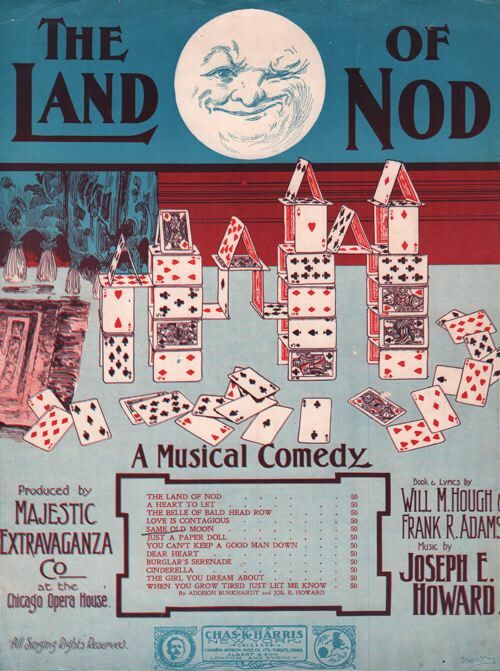
- -
Partition de la chanson : land of nod (The) Juste la couverture, absence de la partition musicale
Partitions sur le Jeu
Referentie van de boekhandelaar : 72247
|
|
|
570 CARTES
ATLAS FRANCE DES VOIES VERTES ET VELOROUTES 12 000 KM
CHAMINA
Referentie van de boekhandelaar : SVBLIVCN-9782844667151
|
|
|
:
[ Semois ] Carte de la Semois d'Arlon à Monthermé. Echelle du 1/80.000. Tirage en 8 couleurs.
Chromolith. map in 2 sheets of 28x55cm and 28x51.5cm, folding back into orig. printed paper covers of 18x11cm. Some trace of use to covers, maps very good.
|
|
|
:
Carta Geologica delle Tre Venezie.
Coloured map, scale 1:100,000, each sheet 40x48cm + broad margins incl. colour legend. Plano, rolled. - AVAILABLE SHEETS: 7bis Vetta d'Italia / 7 Monguelfo / 14 Pontebba / 25 Udine / 37 Bassano del Grappa / 48 Peschiera / 49 Verona / 63 Legnago / 64 Rovigo. - PRICE PER SHEET.
|
|
|
:
Carte de France de l'Etat-Major au 1/80,000. Feuille 11. ABBEVILLE.
Very detailed lithographed topographical map, 52x83.5cm + margins, dissected and mounted on linen, folding back into orig. blind-stamped cloth covers of 20.5x12.8cm. Very good.
|
|
|
:
Carte géologique de France. Echelle 1:80,000. Feuille 84. MIRECOURT.
Chromolithographed map, 50x80cm, dissected and mounted on linen, floding back to 8vo size. Few traces of handling, some light foxing.
|
|
|
:
Carte géologique de l'Algérie. Troisième édition, rectifiée et complétée par la Service de la Carte géologique de l'Algérie [...].
Chromolithographed map, scale 1:800,000, in 4 sheets of 49x66cm + broad margins each, dissected and mounted on linen, folding back to 21.5x20.5cm. Very good. - Final edition of the first large-scale general geological map of Algeria, first published in 1881 as "Carte géologique provisoire"by Pomel and Pouyanne.
|
|
|
:
Carte géologique et agronomique du Département du Haut-Rhin à l'échelle du 1/100.000.
Coloured map, 103x73cm + margins. Folded. With booklet of explanat. text of 31 pp. 4to. Orig. wrs.
|
|
|
:
Forstliche Übersichtskarte des Königreichs Bayern diesseits des Rheins in sechs Blättern.
Very detailed (rivers, villages, wooded areas) lithographed map, scale 1:200,000, in six sheets of 68x92cm each. Some small repairs to blank verso (mostly to margins) not affecting printed area, some dust- or finger-marking, folded vertically one time; over all a good set. The map was intended to be coloured but this is a set in uncoloured state. Rare.
|
|
 De zoekresultaten per email ontvangen
 Zoekresultaten downloaden als PDF
 RSS feed


