|
PETIT Claude
LE BRIDGE CONTRAT. Les annonces.
Editions du Dauphin 1947, In-12 broché de 108 pages.
|
|
|
PETROV (Dimitri).
No Admittance to the Blind Man.
New York Hugo Gallery, s.d. [1945] 1 vol. broché Feuillet plié en trois (format A4) imprimé en noir annonçant une exposition de peintures et travaux automatiques. Formé à l'académie des Beaux-Arts de Pennsylvanie puis à la gravure à l'Atelier 17 avec Stanley Hayter, Dimitri Petrov (1919-1986), américain d'origine russe, était un artiste peintre Dada et surréaliste, membre du Woodstock Artists Association. Document provenant de la bibliothèque de Georges Bataille avec tampon à l'encre noire "Bibliothèque de Georges Bataille".
Référence libraire : 103912
|
|
|
PETRUCCI Yasmine
Le tarot pout tous,guide professionnel et affectif.
Paris, Editions des 7 Vents, 1990 11 x 20, 180 pp,cartonnage éditeur illustré, bon état
Référence libraire : 7539
|
|
|
Peylet Benjamin
Le grand livre escape game Lupin - Saison 2: Résolvez de nouvelles énigmes sur les traces d'Assane
MARABOUT 2022 224 pages 17 8x24 6x2 7cm. 2022. Broché. 224 pages.
Référence libraire : 500115677

|
|
|
PEYOT M.F.
Cours complet de fabrique pour les étoffes de soie. (Texte et Atlas reliés ensemble).
Lyon, Imprimerie Louis Perrin, 1866, 1 volume in-folio de 295x445 mm environ réunissant texte et atlas, (4) ff. (Titres, dédicaces, préface), 240 pages suivies de (2) ff. (Titres), 52 planches en noir et blanc. Pleine toile noire portant titres dorés sur pièce de cuir rouge, gardes couleurs. Reliure solide bien que frottée et tachée, quelques rousseurs marginales, rares annotations au crayon sinon intérieur en bon état.
Référence libraire : 115123
|
|
|
PEYRALBE E. Nombreuses gravures, graphiques et cartes.
Le monde moins l'Europe. Première année. Enseignement primaire supérieur.
Couverture rigide. Cartonnage de l'éditeur. 360 pages. Légèrement défraîchi.
Référence libraire : 144982
|
|
|
Peyre Bernard
Bully 1910-1916 - Correspondance d'Etienne Chabry 1910-1911 Etienne Chabry à Lyon / 1911-1912 Etienne Chabry à Montmélian / 912-1913 Etienne Chabry en Tunisie et au Maroc / 1914-1916 Étienne Chabry à La Guerre.
La Renardière, 2009 - Quatre volumes in Octavo 230 X 225mm complets sous coffret triangulaire laissant à voir les volumes, 183-97-317 et 155 pages, 720 photographies et document commentés dans le texte - en grande part cartes postales - Très bel ensemble pour cette somme monumentale assortie de mentions typographiées dans un cadre gris donnant à cet ensemble un aspect visuel dynamique.
Référence libraire : 12871

|
|
|
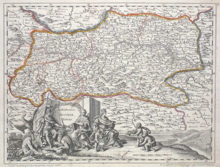
PFEFFEL (Johannes Andreas);
[CARINTHIE] Ducatus Carinthiae tabula.
Augsbourg circa 1740 252 x 333 mm.
Référence libraire : LBW00359
|
|
|
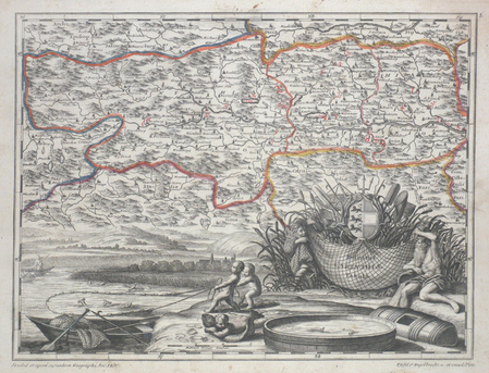
PFEFFEL (Johannes Andreas);
Archiducatus Austriae tabula.
Augsbourg circa 1740 252 x 333 mm.
Référence libraire : LBW027af
|
|
|
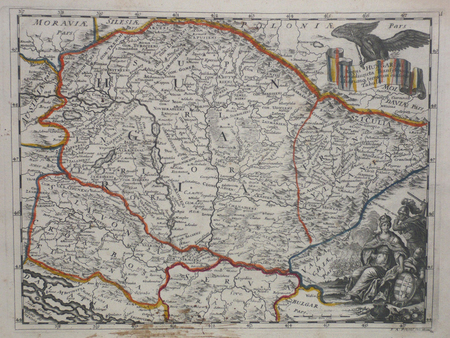
PFEFFEL (Johannes Andreas);
Regni Hungariae cum adiuncta Transylvania.
Augsbourg circa 1740 249 x 331 mm.
Référence libraire : LBW027a2
|
|
|
PFEIFFER, Gustavo.
Mapa de España y Portugal. Panorama de la Península Ibérica. Topografía de M. Herrero. Grabado y publicado por...
Madrid, 1872. 4to., 22 cms; 89 x 65 cms., desplegado. Grabado en color, plegado. Montado sobre tela.. Escala 1:2.000.000. Encuadernación original en tela estampada.

|
|
|
Phelps, Gilbert
Latin America
109 pages, illustrated, maps, appendices, suggestions for further reading. eng
|
|
|
Phelps, Gilbert
Latin America
109 pages, illustrated, maps, appendices, suggestions for further reading. eng
|
|
|
Phenix, Penny; Murphy, Paul
Devon and Exmoor
No marks or inscriptions. No creasing to covers or to spine. A lovely clean very tight copy with bright unmarked boards and no bumping to corners. 128pp.

|
|
|
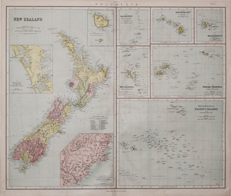
PHILIP & SON.
[NOUVELLE-ZÉLANDE] Polynesia.
London & Liverpool, Philip & Son, [circa 1865]. 520 x 610 mm.
Référence libraire : LBW-3197
|
|
|
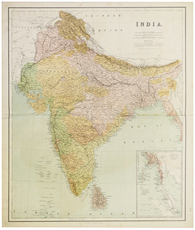
PHILIP (George).
India.
London and Liverpool, George Philip & son, [circa 1890]. 613 x 502 mm.
Référence libraire : LBW-5384
|
|
|
Philip L Barbour with photos maps & tables by Samuel H Bryant
DIMITRY Called the Pretender - Tsar and Great Prince of All Russia 1605 - 1606
Macmillan & Company London 1967 Hardcover 22cms x 15cms with dust jacket Ours is an ex-library copy in transparent protective covering with usual stamps stickers & barcode. GOOD book in GOOD price-clipped dust jacket. Here is the incredible story of Dimitry Tsar of Russia for a single year who was murdered in 1606. The true identity of Dimitry has never been satisfactorily established; however Philip Barbour brings together here for the first time conflicting contemporary accounts and the studies of modern historians to make a narrative which at once illuminates one of the mysteries of European history and is a most absorbing and exciting story. Macmillan & Company, London hardcover
Référence libraire : 42586
|
|
|
Philip Lee Phillips Chief Division of Maps
A List of Geographical Atlases in the Library of Congress with bibliographical notes. Vol. 4: Titles 4068-5324
Government Printing Office. Collectible - Acceptable. Washington: Government Printing Office 1920. Volume 4. Sm 4to. clxiii639pp. Fair book. Spine ends frayed. Boards rubbed and edgeworn corners frayed; front board missing. Front hinge cracked title page detached. Pages generally aged some page edges frayed. Inquire if you need further information. Government Printing Office hardcover
Référence libraire : Q16J-00658
|
|
|
Philip Lee Phillips Chief Division of Maps and Charts
A list of geographical atlases in the Library of Congress with bibliographical notes Vol. 1: Atlases
Government Printing Office. Collectible - Good. Washington: Government Printing Office 1909. Volume 1. Sm 4to. xiii1208pp. Good book. Spine ends frayed. Back joint worn; front board is held on by red binding tape and older clear tape. Boards rubbed and edgeworn corners frayed. Front hinge cracked title page detached. Owner's name on pastedown. First 200 or so pages slightly dampstained at bottom binding edge. Binding cracked at p. 1207. Marginal pencil notations throughout. Inquire if you need further information. Government Printing Office hardcover
Référence libraire : Q16J-00657
|
|
|
Philip Payton ; foreword by AL. Rowse ; maps by Elizabeth Yeardley A. L.
The Cornish Farmer in Australia Or Australian Adventure: Cornish Colonists and the Expansion of Adelaide and the South Australian Agricultural Frontier
Cornwall: Dyllansow Truran 1987. Book. Very Good. Original Cloth. 1st. Scarce hardback edition vRedruth : Dyllansow Truran c1987. xvi 143 p. : ill. maps ports. ; 22 cm. All of our books are in the shop and are 'real' books. We try to post the same day as the order. Descriptions are conservative. Postage rates may be lower than ABE estimate please use Ask Bookseller a Question to confirm availability and postage cost use Ask Bookseller a Question option below to confirm availability and get accurate postage quote for this item the amount quoted is for an 'average' hard-cover book of up to 1kg in weight. Dyllansow Truran Hardcover
Référence libraire : 016472 ISBN : 1850220298 9781850220299
|
|
|
Philip's
Concise World Atlas
224 pages, maps, index. eng
|
|
|
Philip's Maps
2020 Philip's Big Road Atlas Britain and Ireland: A3 Spiral binding
Spiral bound. New. Philip's Big Road Atlas Britain and Ireland 2020 is the large-format atlas with practical spiral binding featuring fully updated maps from the Philip's digital database. The maps are super-clear. They have been voted Britain's clearest and most detailed in an independent consumer survey. unknown
Référence libraire : A9781849075046 ISBN : 1849075042 9781849075046

|
|
|
Philip's Maps
2020 Philip's Motorist's Road Atlas Britain and Ireland: A3 paperback
Paperback / softback. New. Philip's Motorist's Road Atlas Britain and Ireland 2020 is the large-format paperback atlas featuring fully updated maps from the Philip's digital database. The maps are super-clear. They have been voted Britain's clearest and most detailed in an independent consumer survey paperback
Référence libraire : A9781849075053 ISBN : 1849075050 9781849075053

|
|
|
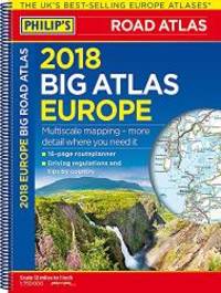
Philip's Maps
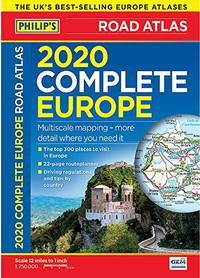
2020 Philip's Complete Road Atlas Europe: A4 Flexiback
Paperback / softback. New. Philip's: the UK's best-selling Europe Atlas range 'The clearest and most detailed maps of Europe' David Williams MBE CEO Gem Motoring Assist Special feature for 2020 'Driving Abroad - avoiding the latest pitfalls' paperback
Référence libraire : A9781849075015 ISBN : 1849075018 9781849075015
|
|
|
Philip's Maps
2020 Philip's Big Road Atlas Europe: A3 Spiral binding
Paperback / softback. New. 'The clearest and most detailed maps of Europe' David Williams MBE CEO Gem Motoring Assist Special feature for 2020 'Driving Abroad - avoiding the latest pitfalls' paperback
Référence libraire : A9781849075008 ISBN : 184907500x 9781849075008

|
|
|
Philip's Maps
2021 Philip's Essential Road Atlas Britain and Ireland: A4 Paperback Philip's Road Atlases
Philip's 2020. Paperback. New. 256 pages. 11.65x8.58x0.55 inches. Philip's paperback
Référence libraire : __1849075336 ISBN : 1849075336 9781849075336
|
|
|
Philip's Maps
2021 Philip's Essential Road Atlas Britain and Ireland: A4 Spiral binding Philip's Road Atlases
Philip's 2020. Spiral-bound. New. 256 pages. 11.77x8.90x0.71 inches. Philip's unknown
Référence libraire : __1849075220 ISBN : 1849075220 9781849075220
|
|
|
Philip's Maps
2021 Philip's Big Road Atlas Britain and Ireland: A3 Spiral binding Philip's Road Atlases
Philip's 2020. Spiral-bound. New. 168 pages. 15.43x11.57x0.55 inches. Philip's unknown
Référence libraire : __1849075247 ISBN : 1849075247 9781849075244
|
|
|
Philip's Maps
2021 Philip's Big Road Atlas Britain and Ireland: A3 Paperback Philip's Road Atlases
Philip's 2020. Paperback. New. 168 pages. 15.43x11.34x0.47 inches. Philip's paperback
Référence libraire : __1849075328 ISBN : 1849075328 9781849075329
|
|
|
Philip's Maps
2021 Philip's Essential Road Atlas Britain and Ireland: A4 Paperback
Paperback / softback. New. Philip's Essential Road Atlas Britain and Ireland 2021 is the top of the range mid-sized paperback atlas featuring fully updated maps from the Philip's digital database. The maps are super-clear. They have been voted Britain's clearest and most detailed in an independent consumer survey. paperback
Référence libraire : A9781849075336 ISBN : 1849075336 9781849075336

|
|
|
Philip's Maps
2021 Philip's Big Road Atlas Britain and Ireland: A3 Paperback
Paperback / softback. New. Philip's Big Road Atlas Britain and Ireland 2021 is the large-format atlas paperback atlas featuring fully updated maps from the Philip's digital database. The maps are super-clear. They have been voted Britain's clearest and most detailed in an independent consumer survey. paperback
Référence libraire : A9781849075329 ISBN : 1849075328 9781849075329

|
|
|
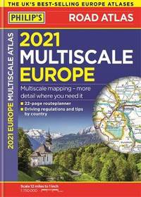
Philip's Maps
2021 Philip's Multiscale Road Atlas Europe: A4 Spiral binding
Spiral bound. New. Philip's: the UK's best-selling Europe Atlas range. All the maps you need for driving in Europe plus key driving regulations for each country. Handy A4 size with lie-flat spiral binding. unknown
Référence libraire : A9781849075299 ISBN : 1849075298 9781849075299

|
|
|
Philip's Maps
2021 Philip's Multiscale Road Atlas Europe: A4 Flexiback
Paperback / softback. New. Philip's: the UK's best-selling Europe Atlas range. All the maps you need for driving in Europe plus key driving regulations for each country. Sturdy flexiback binding. paperback
Référence libraire : A9781849075305 ISBN : 1849075301 9781849075305
|
|
|
Philip's Maps
2021 Philip's Easy to Read Britain Road Atlas: A4 Paperback
Paperback / softback. New. New to the Philip's range of road atlases. Super-clear large-scale maps that everyone can read easily. Practical A4 sized paperback. paperback
Référence libraire : A9781849075350 ISBN : 1849075352 9781849075350

|
|
|
Philip's Maps
2021 Philip's Big Road Atlas Britain and Ireland: A3 Spiral binding
Spiral bound. New. Philip's Big Road Atlas Britain and Ireland 2021 is the large-format atlas with practical spiral binding featuring fully updated maps from the Philip's digital database. The maps are super-clear. They have been voted Britain's clearest and most detailed in an independent consumer survey. unknown
Référence libraire : A9781849075244 ISBN : 1849075247 9781849075244

|
|
|
Philip's Maps
2021 Philip's Essential Road Atlas Britain and Ireland: A4 Spiral binding
Spiral bound. New. Philip's Essential Road Atlas Britain and Ireland 2021 is the top of the range mid-sized spiral-bound atlas featuring fully updated maps from the Philip's digital database. The maps are super-clear. They have been voted Britain's clearest and most detailed in an independent consumer survey. unknown
Référence libraire : A9781849075220 ISBN : 1849075220 9781849075220

|
|
|
Philip's Maps
2021 Philip's Big Road Atlas Europe: A3 Spiral binding
Spiral bound. New. Philip's: the UK's best-selling Europe Atlas range. All the maps you need for driving in Europe plus key driving regulations for each country. Large A3 size with lie-flat spiral binding. unknown
Référence libraire : A9781849075282 ISBN : 184907528x 9781849075282

|
|
|
Philip's Maps
Philip's 2018 Multiscale Road Atlas Europe: A4 Spiral binding
2017-04-06. New. Ships with Tracking Number! INTERNATIONAL WORLDWIDE Shipping available. May be re-issue. Buy with confidence excellent customer service! unknown
Référence libraire : 1849074216n ISBN : 1849074216 9781849074216

|
|
|
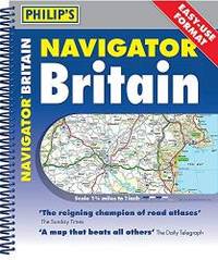
Philip's Maps
Philip's 2019 Navigator Britain Spiral Bound Philips Road Atlas
2018-04-05. New. Ships with Tracking Number! INTERNATIONAL WORLDWIDE Shipping available. May be re-issue. Buy with confidence excellent customer service! unknown
Référence libraire : 1849074747n ISBN : 1849074747 9781849074742

|
|
|
Philip's Maps
Philip's 2020 Navigator Britain Easy Use Format: Spiral
2019-04-18. Good. Ships with Tracking Number! INTERNATIONAL WORLDWIDE Shipping available. May not contain Access Codes or Supplements. May be re-issue. May be ex-library. Shipping & Handling by region. Buy with confidence excellent customer service! unknown
Référence libraire : 1849075107 ISBN : 1849075107 9781849075107

|
|
|
Philip's Maps
Philip's 2020 Navigator Britain Easy Use Format: Spiral
2019-04-18. New. Ships with Tracking Number! INTERNATIONAL WORLDWIDE Shipping available. May be re-issue. Buy with confidence excellent customer service! unknown
Référence libraire : 1849075107n ISBN : 1849075107 9781849075107
|
|
|
Philip's Maps
Philip's 2019 Multiscale Road Atlas Europe: A4 Spiral binding
2018-04-05. New. Ships with Tracking Number! INTERNATIONAL WORLDWIDE Shipping available. May be re-issue. Buy with confidence excellent customer service! unknown
Référence libraire : 184907478Xn ISBN : 184907478x 9781849074780
|
|
|
Philip's Maps
Philip's 2019 Navigator Britain Spiral Bound Philips Road Atlas
2018-04-05. Good. Ships with Tracking Number! INTERNATIONAL WORLDWIDE Shipping available. May not contain Access Codes or Supplements. May be re-issue. May be ex-library. Shipping & Handling by region. Buy with confidence excellent customer service! unknown
Référence libraire : 1849074747 ISBN : 1849074747 9781849074742

|
|
|
Philip's Maps
Philip's 2019 Multiscale Road Atlas Europe: A4 Spiral binding
2018-04-05. Good. Ships with Tracking Number! INTERNATIONAL WORLDWIDE Shipping available. May not contain Access Codes or Supplements. May be re-issue. May be ex-library. Shipping & Handling by region. Buy with confidence excellent customer service! unknown
Référence libraire : 184907478X ISBN : 184907478x 9781849074780

|
|
|
Philip's Maps
Philip's 2019 Essential Navigator Britain Flexi Philips Road Atlas
2018-04-05. New. Ships with Tracking Number! INTERNATIONAL WORLDWIDE Shipping available. May be re-issue. Buy with confidence excellent customer service! unknown
Référence libraire : 1849074763n ISBN : 1849074763 9781849074766

|
|
|
Philip's Maps
Philip's 2018 Multiscale Road Atlas Europe: A4 Spiral binding
2017-04-06. Good. Ships with Tracking Number! INTERNATIONAL WORLDWIDE Shipping available. May not contain Access Codes or Supplements. May be re-issue. May be ex-library. Shipping & Handling by region. Buy with confidence excellent customer service! unknown
Référence libraire : 1849074216 ISBN : 1849074216 9781849074216

|
|
|
Philip's Maps
Philip's 2018 Big Road Atlas Europe: A3 Spiral binding
2017-04-06. Good. Ships with Tracking Number! INTERNATIONAL WORLDWIDE Shipping available. May not contain Access Codes or Supplements. May be re-issue. May be ex-library. Shipping & Handling by region. Buy with confidence excellent customer service! unknown
Référence libraire : 1849074224 ISBN : 1849074224 9781849074223
|
|
|
Philip's Maps
Philip's Big Road Atlas Europe: Spiral A3: A3 Spiral binding Philips Road Atlas
2019-04-04. New. Ships with Tracking Number! INTERNATIONAL WORLDWIDE Shipping available. May be re-issue. Buy with confidence excellent customer service! unknown
Référence libraire : 184907500Xn ISBN : 184907500x 9781849075008

|
|
|
Philip's Maps
Philip's Concise Atlas Britain: Spiral A5
Paperback / softback. New. The essential atlas for planning your trip paperback
Référence libraire : A9781849075077 ISBN : 1849075077 9781849075077

|
|
 Recevoir par e-mail
 Télécharger en PDF
 Flux RSS


