|
PopOut Maps
InsideOut: London Travel Guide : Pocket size London Travel Guide with two pop-up maps
Hardback. As New. London Travel Guide - see the city insideout with this handy pocket size city guide The ultimate London guide book! London has to be the liveliest most enticing most entertaining most cosmopolitan city on Earth. 2500 years in the making it has everything the modern traveller could possibly want hardcover
书商的参考编号 : ria9781845879679_rkm ???????? : 1845879678 9781845879679

|
|
|
PopOut Maps
Istanbul PopOut Map PopOut Maps
2013-02-04. New. Ships with Tracking Number! INTERNATIONAL WORLDWIDE Shipping available. May be re-issue. Buy with confidence excellent customer service! unknown
书商的参考编号 : 1845879406n ???????? : 1845879406 9781845879402

|
|
|
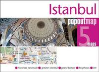
PopOut Maps
Istanbul PopOut Map
Sheet map folded. New. Discover the Turkish delight of Istanbul with this handy pop-up map.This genuinely pocket-sized Istanbul city map includes 2 PopOut maps of central Istanbul & greater Istanbul. Additional maps include a detail map of the Grand Bazaar a transport map and a locator map. Ideal to pop in a pocket or bag for quick reference while exploring the city. unknown
书商的参考编号 : A9781910218242 ???????? : 1910218243 9781910218242

|
|
|
PopOut Maps
Istanbul PopOut Map - pop-up Istanbul city map PopOut Maps
Compass Maps. 2nd edition. Map. Used; Good. Simply Brit Shipped with Premium postal service within 24 hours from the UK with impressive delivery time. We have dispatched from our book depository; items of good condition to over ten million satisfied customers worldwide. We are committed to providing you with reliable and efficient service at all times. 04/15/2013 Compass Maps unknown
书商的参考编号 : 2846205 ???????? : 1845879406 9781845879402
|
|
|
PopOut Maps Creator
Istanbul PopOut Map: Handy pocket-size pop-up map for Istanbul PopOut Maps
Pop Out 2016-07-07. Map. Used:Good. Pop Out unknown
书商的参考编号 : DADAX1910218243 ???????? : 1910218243 9781910218242
|
|
|
PopOut Maps Creator
Istanbul PopOut Map PopOut Maps
PopOut Maps 2013-04-05. Map. Used:Good. PopOut Maps unknown
书商的参考编号 : DADAX1845879406 ???????? : 1845879406 9781845879402
|
|
|
PopOut Maps
Istanbul PopOut Map PopOut Maps
2013-02-04. Good. Ships with Tracking Number! INTERNATIONAL WORLDWIDE Shipping available. May not contain Access Codes or Supplements. May be re-issue. May be ex-library. Shipping & Handling by region. Buy with confidence excellent customer service! unknown
书商的参考编号 : 1845879406 ???????? : 1845879406 9781845879402

|
|
|
PopOut Maps
Istanbul PopOut Map: Handy pocket-size pop-up map for Istanbul PopOut Maps
2016-07-06. New. Ships with Tracking Number! INTERNATIONAL WORLDWIDE Shipping available. May be re-issue. Buy with confidence excellent customer service! unknown
书商的参考编号 : 1910218243n ???????? : 1910218243 9781910218242

|
|
|
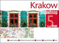
PopOut Maps
Krakow PopOut Map: Handy pocket-size pop up city map of Krakow
Sheet map folded. New. Discover the UNESCO listed beauty of Krakow with this handy pop-up map. This genuinely pocket-sized Krakow city map includes 2 PopOut maps covering Krakow old town and greater Krakow as well as a detail map of Kazimierz and a transit map. Ideal to pop in a pocket or bag for quick reference while exploring the city. unknown
书商的参考编号 : A9781910218839 ???????? : 1910218839 9781910218839
|
|
|
Popout Maps
Las Vegas PopOut Map PopOut Maps
2011-06-01. Good. Ships with Tracking Number! INTERNATIONAL WORLDWIDE Shipping available. May not contain Access Codes or Supplements. May be re-issue. May be ex-library. Shipping & Handling by region. Buy with confidence excellent customer service! unknown
书商的参考编号 : 184587868X ???????? : 184587868x 9781845878689

|
|
|
PopOut Maps
Las Vegas PopOut Map PopOut Maps
2014-01-04. New. Ships with Tracking Number! INTERNATIONAL WORLDWIDE Shipping available. May be re-issue. Buy with confidence excellent customer service! unknown
书商的参考编号 : 1845879880n ???????? : 1845879880 9781845879884

|
|
|
PopOut Maps
Lisbon PopOut Map
Sheet map folded. New. Uncover Portugal's majestic capital city of Lisbon with this handy pop-up map. This genuinely pocket-sized Lisbon city map includes 2 PopOut maps covering central Lisbon and greater Lisbon as well as additional maps of the Lisbon area nearby Belem and a transport map. Ideal to pop in a pocket or bag for quick reference while exploring the city. unknown
书商的参考编号 : A9781910218488 ???????? : 1910218480 9781910218488

|
|
|
Popout Maps Corporate Author
Lisbon Popout Map
Compass Maps Ltd 2017. Paperback. New. fol map edition. 4.00x5.25x0.25 inches. Compass Maps Ltd paperback
书商的参考编号 : 2-1910218480 ???????? : 1910218480 9781910218488
|
|
|
Popout Maps
Lisbon PopOut Map PopOut Maps
Footprint PopOut Maps 09/16/2011. 1e. Map. Used; Good. WE SHIP WITHIN 24 HRS FROM LONDON UK 98% OF OUR ORDERS ARE RECEIVED WITHIN 7-10 DAYS. We believe you will be completely satisfied with our quick and reliable service. All orders are dispatched as swiftly as possible! Buy with confidence! Footprint PopOut Maps unknown
书商的参考编号 : 3684106 ???????? : 0711600301209 0711600301
|
|
|
Popout Maps
Lisbon Popout Map Popout Maps
PopOut Maps. Fol Map. Map. Used; Good. Simply Brit Shipped with Premium postal service within 24 hours from the UK with impressive delivery time. We have dispatched from our book depository; items of good condition to over ten million satisfied customers worldwide. We are committed to providing you with reliable and efficient service at all times. 09/09/2014 PopOut Maps unknown
书商的参考编号 : 2964284 ???????? : 1845879953 9781845879952

|
|
|
Popout Maps
Lisbon PopOut Map PopOut Maps
2011-09-23. Good. Ships with Tracking Number! INTERNATIONAL WORLDWIDE Shipping available. May not contain Access Codes or Supplements. May be re-issue. May be ex-library. Shipping & Handling by region. Buy with confidence excellent customer service! unknown
书商的参考编号 : 1845878825 ???????? : 1845878825 9781845878825

|
|
|
PopOut Maps Creator
Lisbon PopOut Map PopOut Maps
Pop Out 2014-09-08. Map. Used:Good. Pop Out unknown
书商的参考编号 : DADAX1845879953 ???????? : 1845879953 9781845879952
|
|
|
PopOut Maps Creator
Lisbon PopOut Map PopOut Maps
Pop Out 2017-10-03. Map. Used:Good. Pop Out unknown
书商的参考编号 : DADAX1910218480 ???????? : 1910218480 9781910218488
|
|
|
PopOut Maps
Lisbon PopOut Map PopOut Maps
2014-07-04. New. Ships with Tracking Number! INTERNATIONAL WORLDWIDE Shipping available. May be re-issue. Buy with confidence excellent customer service! unknown
书商的参考编号 : 1845879953n ???????? : 1845879953 9781845879952

|
|
|
PopOut Maps Creator
London Bus & Underground PopOut Map PopOut Maps
Pop Out 2017-04-01. Map. Very Good. Pop Out unknown
书商的参考编号 : 1910218162-2-18619694 ???????? : 1910218162 9781910218167
|
|
|
Popout Maps
London Bus/underground PopOut Map Popout Maps
2011-01-01. Good. Ships with Tracking Number! INTERNATIONAL WORLDWIDE Shipping available. May not contain Access Codes or Supplements. May be re-issue. May be ex-library. Shipping & Handling by region. Buy with confidence excellent customer service! unknown
书商的参考编号 : 1845878582 ???????? : 1845878582 9781845878580

|
|
|
PopOut Maps Creator
London Bus and Underground PopOut Map PopOut Maps
PopOut Maps 2014-04-02. Map. Used:Good. PopOut Maps unknown
书商的参考编号 : DADAX1845879503 ???????? : 1845879503 9781845879501

|
|
|
PopOut Maps Creator
London Bus & Underground PopOut Map PopOut Maps
Pop Out 2017-04-01. Map. Used:Good. Pop Out unknown
书商的参考编号 : DADAX1910218162 ???????? : 1910218162 9781910218167
|
|
|
Popout Maps
London InsideOut Travel Guide: Pocket size London Travel Guide with Two Pop-up Maps
2014-01-07. New. Ships with Tracking Number! INTERNATIONAL WORLDWIDE Shipping available. May be re-issue. Buy with confidence excellent customer service! unknown
书商的参考编号 : 1845879678n ???????? : 1845879678 9781845879679

|
|
|
PopOut Maps
London PopOut Map
Sheet map folded. New. Discover London England's glorious capital city with this handy pop-up map. This pocket-sized city map includes 2 PopOut maps covering central London & the West End with additional maps of the main bus routes the underground & theatreland with all the key theatres highlighted. Ideal to pop in a pocket bag for quick reference while exploring. unknown
书商的参考编号 : A9781910218723 ???????? : 1910218723 9781910218723

|
|
|
PopOut Maps
London PopOut Map: 3 PopOut maps in one handy pocket-size format
Sheet map folded. New. Put the wonderful & thrilling city of London in your pocket with this handy pop-up map. This genuinely pocket-sized map includes 3 PopOut Maps - central London the West End & the whole tube network. In addition there is a detail map of Theatreland and a bus route map. Ideal to pop in a pocket or bag for quick reference while exploring the city. unknown
书商的参考编号 : A9781910218761 ???????? : 1910218766 9781910218761

|
|
|
PopOut Maps Creator
London PopOut Map PopOut Maps
PopOut Maps 2016-02-26. Map. New. PopOut Maps unknown
书商的参考编号 : 1910218146-11-17898057 ???????? : 1910218146 9781910218143
|
|
|
PopOut Maps Creator
London PopOut Map PopOut Maps
Pop Out 2016-02-07. Map. Used:Good. Pop Out unknown
书商的参考编号 : DADAX1910218146 ???????? : 1910218146 9781910218143
|
|
|
PopOut Maps
London PopOut Map PopOut Maps
2014-06-05. Good. Ships with Tracking Number! INTERNATIONAL WORLDWIDE Shipping available. May not contain Access Codes or Supplements. May be re-issue. May be ex-library. Shipping & Handling by region. Buy with confidence excellent customer service! unknown
书商的参考编号 : 1845879481 ???????? : 1845879481 9781845879488

|
|
|
PopOut Maps
London Popout Map: 3 Popout Maps in One Handy Pocket-Size Format
2016-05-06. New. Ships with Tracking Number! INTERNATIONAL WORLDWIDE Shipping available. May be re-issue. Buy with confidence excellent customer service! unknown
书商的参考编号 : 1910218189n ???????? : 1910218189 9781910218181

|
|
|
PopOut Maps
London PopOut Map PopOut Maps
2016-05-08. New. Ships with Tracking Number! INTERNATIONAL WORLDWIDE Shipping available. May be re-issue. Buy with confidence excellent customer service! unknown
书商的参考编号 : 1910218146n ???????? : 1910218146 9781910218143

|
|
|
Popout Maps
Los Angeles PopOut Map Popout Maps
Footprint Travel Guides. Map. GOOD. Spine creases wear to binding and pages from reading. May contain limited notes underlining or highlighting that does affect the text. Possible ex library copy will have the markings and stickers associated from the library. Accessories such as CD codes toys may not be included. Footprint Travel Guides unknown
书商的参考编号 : 3198471065 ???????? : 1845878779 9781845878771
|
|
|
Popout Maps Corporate Author
Los Angeles Popout Map
Compass Maps Ltd 2016. Paperback. New. fol map re edition. 2 pages. 5.50x4.00x0.25 inches. Compass Maps Ltd paperback
书商的参考编号 : __1910218278 ???????? : 1910218278 9781910218273
|
|
|
PopOut Maps
Los Angeles PopOut Map
Sheet map. New. Get to the heart of Los Angeles the city of angels with the help of this genuinely pocket-sized pop-up map. Small in size yet big on detail this compact dependable Los Angeles city map will ensure you don't miss a thing. Includes 2 PopOut maps - an overview map of LA County and a detailed str unknown
书商的参考编号 : ria9781910218273_new ???????? : 1910218278 9781910218273
|
|
|
PopOut Maps
Los Angeles PopOut Map PopOut Maps
2013-06-09. New. Ships with Tracking Number! INTERNATIONAL WORLDWIDE Shipping available. May be re-issue. Buy with confidence excellent customer service! unknown
书商的参考编号 : 1845879562n ???????? : 1845879562 9781845879563

|
|
|
PopOut Maps
Los Angeles PopOut Map PopOut Maps
2016-04-05. New. Ships with Tracking Number! INTERNATIONAL WORLDWIDE Shipping available. May be re-issue. Buy with confidence excellent customer service! unknown
书商的参考编号 : 1910218278n ???????? : 1910218278 9781910218273

|
|
|
PopOut Maps
Los Angeles PopOut Map
Sheet map. As New. Get to the heart of Los Angeles the city of angels with the help of this genuinely pocket-sized pop-up map. Small in size yet big on detail this compact dependable Los Angeles city map will ensure you don't miss a thing. Includes 2 PopOut maps - an overview map of LA County and a detailed str unknown
书商的参考编号 : ria9781910218273_rkm ???????? : 1910218278 9781910218273
|
|
|
Popout Maps
Madrid PopOut Map: pop-up city street map of Madrid city center - folded pocket size travel map with transit map included PopOut Maps
2009-09-02. Good. Ships with Tracking Number! INTERNATIONAL WORLDWIDE Shipping available. May not contain Access Codes or Supplements. May be re-issue. May be ex-library. Shipping & Handling by region. Buy with confidence excellent customer service! unknown
书商的参考编号 : 184587787X ???????? : 184587787x 9781845877873

|
|
|
Popout Maps
Madrid PopOut Map Popout Maps
Footprint PopOut Maps 09/16/2011. 1e. Map. Used; Good. WE SHIP WITHIN 24 HRS FROM LONDON UK 98% OF OUR ORDERS ARE RECEIVED WITHIN 7-10 DAYS. We believe you will be completely satisfied with our quick and reliable service. All orders are dispatched as swiftly as possible! Buy with confidence! Footprint PopOut Maps unknown
书商的参考编号 : 2388951 ???????? : 1845878752 9781845878757
|
|
|
PopOut Maps
Manchester PopOut Map PopOut Maps
2004-04-02. New. Ships with Tracking Number! INTERNATIONAL WORLDWIDE Shipping available. May be re-issue. Buy with confidence excellent customer service! unknown
书商的参考编号 : 1910218618n ???????? : 1910218618 9781910218617
|
|
|
PopOut Maps
Manchester PopOut Map PopOut Maps
2001-01-01. New. Ships with Tracking Number! INTERNATIONAL WORLDWIDE Shipping available. May be re-issue. Buy with confidence excellent customer service! unknown
书商的参考编号 : 1845879309n ???????? : 1845879309 9781845879303

|
|
|
PopOut Maps
Marrakesh PopOut Map: Handy pocket size pop up city map of Marrakesh
Sheet map folded. New. Uncover the exotic charms of Marrakesh with this handy pop-up map. This genuinely pocket-sized Marrakesh city map includes 2 PopOut maps featuring a street map of central Marrakesh an overview map of greater Marrakesh with additional maps showing the Souks Gueliz and around Marrakesh. Ideal to pop in a pocket or bag for quick reference. unknown
书商的参考编号 : A9781910218822 ???????? : 1910218820 9781910218822

|
|
|
Popout Maps
Marrakesh PopOut Map Popout Maps
Footprint PopOut Maps 09/16/2011. New edition. Map. Used; Good. WE SHIP WITHIN 24 HRS FROM LONDON UK 98% OF OUR ORDERS ARE RECEIVED WITHIN 7-10 DAYS. We believe you will be completely satisfied with our quick and reliable service. All orders are dispatched as swiftly as possible! Buy with confidence! Footprint PopOut Maps unknown
书商的参考编号 : 3495335 ???????? : 1845878760 9781845878764
|
|
|
PopOut Maps Creator
Melbourne PopOut Map PopOut Maps
Pop Out 2014-07-25. Map. Used:Good. Pop Out unknown
书商的参考编号 : DADAX1845879937 ???????? : 1845879937 9781845879938

|
|
|
PopOut Maps
Melbourne PopOut Map PopOut Maps
2014-09-04. New. Ships with Tracking Number! INTERNATIONAL WORLDWIDE Shipping available. May be re-issue. Buy with confidence excellent customer service! unknown
书商的参考编号 : 1845879937n ???????? : 1845879937 9781845879938

|
|
|
Popout Maps Creator
Miami Popout Map: Handy Pocket-size Pop-up Map of Miami
Compass Maps Ltd 2015. Map. New. map edition. 2 pages. 3.50x5.00x0.25 inches. Compass Maps Ltd unknown
书商的参考编号 : __1910218081 ???????? : 1910218081 9781910218082
|
|
|
PopOut Maps
Miami Popout Map PopOut Maps
PopOut Maps 10/30/2015. Map. Map. Used; Good. WE SHIP WITHIN 24 HRS FROM LONDON UK 98% OF OUR ORDERS ARE RECEIVED WITHIN 7-10 DAYS. We believe you will be completely satisfied with our quick and reliable service. All orders are dispatched as swiftly as possible! Buy with confidence! PopOut Maps unknown
书商的参考编号 : 3741527 ???????? : 0711600302339 0711600302
|
|
|
Popout Maps
Miami PopOut Map: Handy pocket-size pop-up map of Miami PopOut Maps
2015-07-02. New. Ships with Tracking Number! INTERNATIONAL WORLDWIDE Shipping available. May be re-issue. Buy with confidence excellent customer service! unknown
书商的参考编号 : 1910218081n ???????? : 1910218081 9781910218082

|
|
|
PopOut Maps
Milan PopOut Map PopOut Maps
2015-04-03. New. Ships with Tracking Number! INTERNATIONAL WORLDWIDE Shipping available. May be re-issue. Buy with confidence excellent customer service! unknown
书商的参考编号 : 1910218057n ???????? : 1910218057 9781910218051

|
|
|
PopOut Maps
Munich PopOut Map
Sheet map folded. New. Uncover the Bavarian wonder of Munich with this handy pop-up map. This genuinely pocket-sized Munich city map includes 2 PopOut maps featuring: a street map of central Munich an overview map of greater Munich as well as an additional locator map and metro map. Ideal to pop in a pocket or bag for quick reference while exploring the city. unknown
书商的参考编号 : A9781910218655 ???????? : 1910218650 9781910218655

|
|
 ?????????
 ?????PDF???
 RSS feed


