|
PopOut Maps
San Francisco PopOut Map
Sheet map folded. New. Let PopOut show you around San Francisco's iconic sights. This handy pocket-sized pop-up city map includes 2 PopOut maps greater San Francisco including Golden Gate Park and a detail map of Downtown San Francisco. Additional maps of Fisherman's Wharf & Pier 39 the San Francisco Bay area and a transit map are also included. unknown
Referencia librero : A9781910218785 ISBN : 1910218782 9781910218785

|
|
|
PopOut Maps
San Francisco PopOut Map PopOut Maps
2013-07-06. Good. Ships with Tracking Number! INTERNATIONAL WORLDWIDE Shipping available. May not contain Access Codes or Supplements. May be re-issue. May be ex-library. Shipping & Handling by region. Buy with confidence excellent customer service! unknown
Referencia librero : 1845879600 ISBN : 1845879600 9781845879600

|
|
|
PopOut Maps
Seattle PopOut Map PopOut Maps
2013-06-01. New. Ships with Tracking Number! INTERNATIONAL WORLDWIDE Shipping available. May be re-issue. Buy with confidence excellent customer service! unknown
Referencia librero : 1845879511n ISBN : 1845879511 9781845879518

|
|
|
PopOut Maps
Seattle PopOut Map PopOut Maps
2013-06-01. Good. Ships with Tracking Number! INTERNATIONAL WORLDWIDE Shipping available. May not contain Access Codes or Supplements. May be re-issue. May be ex-library. Shipping & Handling by region. Buy with confidence excellent customer service! unknown
Referencia librero : 1845879511 ISBN : 1845879511 9781845879518

|
|
|
PopOut Maps
Shanghai PopOut Map PopOut Maps
2014-06-08. New. Ships with Tracking Number! INTERNATIONAL WORLDWIDE Shipping available. May be re-issue. Buy with confidence excellent customer service! unknown
Referencia librero : 184587997Xn ISBN : 184587997x 9781845879976

|
|
|
PopOut Maps
Singapore PopOut Map
Sheet map folded. New. Experience the bustling city of Singapore with the help of this genuinely pocket-sized pop-up map. Small in size yet big on detail this compact dependable city map will ensure you don't miss a thing. unknown
Referencia librero : A9781910218679 ISBN : 1910218677 9781910218679

|
|
|
PopOut Maps Creator
Singapore PopOut Map PopOut Maps
PopOut Maps 2013-05-09. Map. Used:Good. PopOut Maps unknown
Referencia librero : DADAX1845879414 ISBN : 1845879414 9781845879419

|
|
|
PopOut Maps
Stockholm Double PopOut Map PopOut Maps
Compass Maps 03/07/2011. New edition. Map. Used; Good. WE SHIP WITHIN 24 HRS FROM LONDON UK 98% OF OUR ORDERS ARE RECEIVED WITHIN 7-10 DAYS. We believe you will be completely satisfied with our quick and reliable service. All orders are dispatched as swiftly as possible! Buy with confidence! Compass Maps unknown
Referencia librero : 3563754 ISBN : 1845878450 9781845878450
|
|
|
PopOut Maps Creator
Stockholm PopOut Map: Handy pocket size pop-up map of Stockholm PopOut Maps
PopOut Maps 2014-05-07. Map. Used:Good. PopOut Maps unknown
Referencia librero : DADAX1845879872 ISBN : 1845879872 9781845879877

|
|
|
PopOut Maps
Stockholm PopOut Map: pop-up city street map of Stockholm city center - folded pocket size travel map with transit map included PopOut Maps
2011-03-03. Good. Ships with Tracking Number! INTERNATIONAL WORLDWIDE Shipping available. May not contain Access Codes or Supplements. May be re-issue. May be ex-library. Shipping & Handling by region. Buy with confidence excellent customer service! unknown
Referencia librero : 1845878450 ISBN : 1845878450 9781845878450

|
|
|
PopOut Maps
Stockholm PopOut Map: Handy pocket size pop-up map of Stockholm PopOut Maps
2014-03-07. New. Ships with Tracking Number! INTERNATIONAL WORLDWIDE Shipping available. May be re-issue. Buy with confidence excellent customer service! unknown
Referencia librero : 1845879872n ISBN : 1845879872 9781845879877

|
|
|
PopOut Maps
Sydney PopOut Map
Sheet map folded. New. Discover the surf sun and stunning icons of Sydney with this handy pop-up map.This genuinely pocket-sized city map includes 2 PopOut maps of central Sydney and greater Sydney as well as additional maps of Darling Harbour the Sydney area and the cityrail network. Ideal to pop in a pocket or bag for quick reference while exploring the city. unknown
Referencia librero : A9781910218860 ISBN : 1910218863 9781910218860

|
|
|
Popout Maps
Sydney PopOut Map: pop-up city street map of Sydney city center - folded pocket size travel map with transit map included PopOut Maps
2011-08-09. Good. Ships with Tracking Number! INTERNATIONAL WORLDWIDE Shipping available. May not contain Access Codes or Supplements. May be re-issue. May be ex-library. Shipping & Handling by region. Buy with confidence excellent customer service! unknown
Referencia librero : 1845878701 ISBN : 1845878701 9781845878702

|
|
|
PopOut Maps
Sydney PopOut Map PopOut Maps
2013-07-02. New. Ships with Tracking Number! INTERNATIONAL WORLDWIDE Shipping available. May be re-issue. Buy with confidence excellent customer service! unknown
Referencia librero : 1845879619n ISBN : 1845879619 9781845879617

|
|
|
Popout Maps
Tokyo PopOut Map PopOut Maps
2011-09-23. New. Ships with Tracking Number! INTERNATIONAL WORLDWIDE Shipping available. May be re-issue. Buy with confidence excellent customer service! unknown
Referencia librero : 1845878965n ISBN : 1845878965 9781845878962

|
|
|
Popout Maps
Tokyo PopOut Map: pop-up city street map of Tokyo city center - folded pocket size travel map with transit map included PopOut Maps
2008-08-07. Good. Ships with Tracking Number! INTERNATIONAL WORLDWIDE Shipping available. May not contain Access Codes or Supplements. May be re-issue. May be ex-library. Shipping & Handling by region. Buy with confidence excellent customer service! unknown
Referencia librero : 1845877071 ISBN : 1845877071 9781845877071

|
|
|
Popout Maps
Tokyo PopOut Map PopOut Maps
2011-09-23. Good. Ships with Tracking Number! INTERNATIONAL WORLDWIDE Shipping available. May not contain Access Codes or Supplements. May be re-issue. May be ex-library. Shipping & Handling by region. Buy with confidence excellent customer service! unknown
Referencia librero : 1845878965 ISBN : 1845878965 9781845878962

|
|
|
PopOut Maps
Tokyo PopOut Map PopOut Maps
PopOut Maps 2015-08-07. Map. Used:Good. PopOut Maps unknown
Referencia librero : DADAX191021812X ISBN : 191021812X 9781910218129

|
|
|
PopOut Maps
Tokyo PopOut Map PopOut Maps
2015-06-07. New. Ships with Tracking Number! INTERNATIONAL WORLDWIDE Shipping available. May be re-issue. Buy with confidence excellent customer service! unknown
Referencia librero : 191021812Xn ISBN : 191021812x 9781910218129

|
|
|
Popout Maps
Toronto Popout Map Footprint Popout Maps
Footprint Travel Guides. Used - Very Good. Ships from the UK. Former Library book. Great condition for a used book! Minimal wear. 100% Money Back Guarantee. Your purchase also supports literacy charities. Footprint Travel Guides unknown
Referencia librero : GRP111802352 ISBN : 1845878957 9781845878955
|
|
|
PopOut Maps
Venice PopOut Map PopOut Maps
2013-06-09. New. Ships with Tracking Number! INTERNATIONAL WORLDWIDE Shipping available. May be re-issue. Buy with confidence excellent customer service! unknown
Referencia librero : 1845879368n ISBN : 1845879368 9781845879365

|
|
|
PopOut Maps
Venice PopOut Map PopOut Maps
2009-05-01. New. Ships with Tracking Number! INTERNATIONAL WORLDWIDE Shipping available. May be re-issue. Buy with confidence excellent customer service! unknown
Referencia librero : 1845877888n ISBN : 1845877888 9781845877880

|
|
|
PopOut Maps
Venice PopOut Map
Sheet map folded. New. Discover the magical canals and romantic palaces of Venice with this handy pop-up map. This genuinely pocket-sized Venice city map includes 2 PopOut maps of central Venice and greater Venice as well as additional maps of Venice Lagoon and the waterbus services. Ideal to pop in a pocket or bag for quick reference while exploring this stunning city. unknown
Referencia librero : A9781910218778 ISBN : 1910218774 9781910218778

|
|
|
PopOut Maps
Venice PopOut Map PopOut Maps
2009-05-01. Good. Ships with Tracking Number! INTERNATIONAL WORLDWIDE Shipping available. May not contain Access Codes or Supplements. May be re-issue. May be ex-library. Shipping & Handling by region. Buy with confidence excellent customer service! unknown
Referencia librero : 1845877888 ISBN : 1845877888 9781845877880

|
|
|
PopOut Maps Creator
Venice PopOut Map: Handy Pocket-sized Pop-up Map for Venice PopOut Maps
Pop Out 2016-06-07. Map. Used:Good. Pop Out unknown
Referencia librero : DADAX1910218227 ISBN : 1910218227 9781910218228
|
|
|
PopOut Maps
Venice PopOut Map PopOut Maps
2013-06-09. Good. Ships with Tracking Number! INTERNATIONAL WORLDWIDE Shipping available. May not contain Access Codes or Supplements. May be re-issue. May be ex-library. Shipping & Handling by region. Buy with confidence excellent customer service! unknown
Referencia librero : 1845879368 ISBN : 1845879368 9781845879365

|
|
|
PopOut Maps
Vienna PopOut Map PopOut Maps
2013-08-02. New. Ships with Tracking Number! INTERNATIONAL WORLDWIDE Shipping available. May be re-issue. Buy with confidence excellent customer service! unknown
Referencia librero : 1845879376n ISBN : 1845879376 9781845879372

|
|
|
PopOut Maps
Vienna PopOut Map
Sheet map folded. New. Step into the Austrian capital city of Vienna in all its imperial grandeur with this handy pop-up map.This pocket-sized Vienna city map includes 2 PopOut maps of central Vienna & greater Vienna as well plus maps of Schonbrunn Palace & the Vienna U-bahn & S-bahn. Ideal to pop in a pocket or bag for quick reference while exploring the city. unknown
Referencia librero : A9781910218808 ISBN : 1910218804 9781910218808

|
|
|
PopOut Maps
Vienna PopOut Map PopOut Maps
PopOut Maps. 01. Paperback. Used; Good. Simply Brit Shipped with Premium postal service within 24 hours from the UK with impressive delivery time. We have dispatched from our book depository; items of good condition to over ten million satisfied customers worldwide. We are committed to providing you with reliable and efficient service at all times. 05/01/2019 PopOut Maps paperback
Referencia librero : 3046784 ISBN : 1910218804 9781910218808
|
|
|
PopOut Maps Creator
Vienna PopOut Map: Handy pocket-size pop-up map for Vienna PopOut Maps
Pop Out 2016-06-07. Map. Used:Good. Pop Out unknown
Referencia librero : DADAX1910218235 ISBN : 1910218235 9781910218235
|
|
|
PopOut Maps
Vienna PopOut Map: pop-up city street map of Vienna city center - folded pocket size travel map with transit map included PopOut Maps
Compass Maps Ltd. Used - Like New. Like New condition. Pop out map inside. Compass Maps Ltd unknown
Referencia librero : R05B-02804 ISBN : 1845878248 9781845878245
|
|
|
PopOut Maps
Vienna PopOut Map PopOut Maps
2013-08-02. Good. Ships with Tracking Number! INTERNATIONAL WORLDWIDE Shipping available. May not contain Access Codes or Supplements. May be re-issue. May be ex-library. Shipping & Handling by region. Buy with confidence excellent customer service! unknown
Referencia librero : 1845879376 ISBN : 1845879376 9781845879372

|
|
|
PopOut Maps
Vienna PopOut Map: Handy pocket-size pop-up map for Vienna PopOut Maps
2016-07-03. New. Ships with Tracking Number! INTERNATIONAL WORLDWIDE Shipping available. May be re-issue. Buy with confidence excellent customer service! unknown
Referencia librero : 1910218235n ISBN : 1910218235 9781910218235

|
|
|
PopOut Maps
Washington DC PopOut Map
Sheet map folded. New. Discover the many magnificent monuments and museums of America's capital Washington DC with this handy pop-up map. This is the ideal map to pop in a pocket or bag for quick reference while exploring the political and cultural heart of America. It includes maps of Greater Washington The Mall Georgetown Dupont Circle and Metro rail system. unknown
Referencia librero : A9781910218549 ISBN : 1910218545 9781910218549

|
|
|
PopOut Maps
Washington DC Popout Map Popout Maps
Compass Maps 10/15/2012. New. Map. Used; Good. WE SHIP WITHIN 24 HRS FROM LONDON UK 98% OF OUR ORDERS ARE RECEIVED WITHIN 7-10 DAYS. We believe you will be completely satisfied with our quick and reliable service. All orders are dispatched as swiftly as possible! Buy with confidence! Compass Maps unknown
Referencia librero : 3619221 ISBN : 1845879198 9781845879198

|
|
|
PopOut Maps
Washington DC Popout Map Popout Maps
Compass Maps 10/15/2012. New. Map. Used; Good. WE SHIP WITHIN 24 HRS FROM LONDON UK 98% OF OUR ORDERS ARE RECEIVED WITHIN 7-10 DAYS. We believe you will be completely satisfied with our quick and reliable service. All orders are dispatched as swiftly as possible! Buy with confidence! Compass Maps unknown
Referencia librero : 3488185 ISBN : 1845879198 9781845879198
|
|
|
PopOut Maps Creator
Washington DC PopOut Map PopOut Maps
PopOut Maps 2015-09-30. Map. Used:Good. PopOut Maps unknown
Referencia librero : DADAX191021809X ISBN : 191021809X 9781910218099
|
|
|
Popout Maps
Washington DC PopOut Map PopOut Maps
2012-02-07. New. Ships with Tracking Number! INTERNATIONAL WORLDWIDE Shipping available. May be re-issue. Buy with confidence excellent customer service! unknown
Referencia librero : 1845879198n ISBN : 1845879198 9781845879198

|
|
|
Popout Maps
Washington DC PopOut Map PopOut Maps
2012-02-07. Good. Ships with Tracking Number! INTERNATIONAL WORLDWIDE Shipping available. May not contain Access Codes or Supplements. May be re-issue. May be ex-library. Shipping & Handling by region. Buy with confidence excellent customer service! unknown
Referencia librero : 1845879198 ISBN : 1845879198 9781845879198

|
|
|
PopOut Maps
Washington D.C. PopOut Map PopOut Maps
2015-08-05. New. Ships with Tracking Number! INTERNATIONAL WORLDWIDE Shipping available. May be re-issue. Buy with confidence excellent customer service! unknown
Referencia librero : 191021809Xn ISBN : 191021809x 9781910218099

|
|
|
PopOut Maps
York PopOut Map PopOut Maps
2019-05-23. New. Ships with Tracking Number! INTERNATIONAL WORLDWIDE Shipping available. May be re-issue. Buy with confidence excellent customer service! unknown
Referencia librero : 1913052001n ISBN : 1913052001 9781913052003

|
|
|
PopOut Maps
York PopOut Map
Sheet map folded. New. Get to the heart of the historic walled city of York with this handy pop-up map. This genuinely pocket-sized city map of York features a detailed street map of York as well as advice on the top things to see while you're there. Ideal to pop in a pocket or bag for quick reference while exploring the city. unknown
Referencia librero : A9781913052003 ISBN : 1913052001 9781913052003

|
|
|
PopOut Maps
York PopOut Map PopOut Maps
2017-02-24. Good. Ships with Tracking Number! INTERNATIONAL WORLDWIDE Shipping available. May not contain Access Codes or Supplements. May be re-issue. May be ex-library. Shipping & Handling by region. Buy with confidence excellent customer service! unknown
Referencia librero : 1910218391 ISBN : 1910218391 9781910218396

|
|
|
PopOut Maps
Zurich PopOut Map
Sheet map folded. New. Explore Zurich with ease with this pocket-sized pop-up map. This handy tourist map includes 2 PopOut maps of greater Zurich and central Zurich with additional maps locating Zurich and its surrounding area and the transport system. Ideal to pop in a pocket or bag for quick reference while exploring the city. unknown
Referencia librero : A9781910218556 ISBN : 1910218553 9781910218556

|
|
|
Popout Maps Creator
Zurich Popout Map
Compass Maps Ltd 2018. Paperback. New. fol map edition. 3.75x5.25x0.25 inches. Compass Maps Ltd paperback
Referencia librero : __1910218553 ISBN : 1910218553 9781910218556
|
|
|
PopOut Maps Creator
Zurich PopOut Map PopOut Maps
Pop Out 2018-05-07. Map. Used:Good. Pop Out unknown
Referencia librero : DADAX1910218553 ISBN : 1910218553 9781910218556
|
|
|
POPULATION MONTAGNARDE en SUISSE par Forum alpinum et Clubs de livres suisses.
Forum alpinum. Montagnes sans avenir ? Texte en allemand, français, italien et romanche. Richt documenté (héliogravures, gravures , dessins, cartes). Avec un disque 33 tours, anthologie de musique populaire des régions montagnardes suisses.
Zurich, Forum aplinum 1965. Bel exemplaire relié, rel. pleine toile et jaquette ornées d'éd., fort in-4, 432 pages + disque.
Referencia librero : AUB-5302
|
|
|
PORCACCHI (Tommaso);
[ANGLETERRE] Descrittione dell'isola d'Inghilterra.
Venise 1576 104 x 142 mm.
Referencia librero : LBW004f5
|
|
|
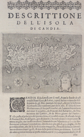
PORCACCHI (Tommaso);
[CRETE] Descrittione dell'isola di Candia.
Venise 1576 105 x 141 mm.
Referencia librero : LBW004ef
|
|
|
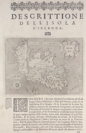
PORCACCHI (Tommaso);
[IRLANDE] Descrittione dell'isola d'Irlanda.
Venise 1576 104 x 141 mm.
Referencia librero : LBW004f6
|
|
 Recibir por correo electrónico
 Descargar en documento PDF
 Flujo RSS


