|
|
|
ROBIQUET (Aimé).
Carte des terres et des mers connues du globe indiquant les courants, les vents généraux et les principales routes.
Paris, Aimé Robiquet, 1856. 635 x 892 mm.
书商的参考编号 : LBW-8245

|
|
|
Robson EI. Text Howard JR. E. Maps & illustrations E. I. J. R.
A WAYFARER ON THE LOIRE.
BOSTON: HOUGHTON MIFFLIN AND COMPANY. Very Good in Very Good dust jacket. 1926. First Edition; First Printing. Hardcover. First American edition. Very good copy in a very good dust jacket. Light traces of shelf soiling at edges of text. Shallow chipping at spine ends on jacket. A few short edge tears in. Uncommon in jacket. ; 220 pages . HOUGHTON, MIFFLIN AND COMPANY. hardcover
书商的参考编号 : 311928
|
|
|
Robson, John
Captain Cook's World. Maps of the Life and Voyages of James Cook R.N.
New Zealand, Random House, 2000. 211 p. with 128 maps and a gazetteer. 30,5 x 25 cm, hardcover with original wrappers.
书商的参考编号 : 23956
|
|
|
ROCHE Aimé O. M. I:
Clartés Australes Joseph Gérard, O. M. I. Le "Prêtre bien-aimé des Basotho" (1831-1914) Préface de Son Em. Mgr. Feltin, Archevêque de Paris.
Lyon, Éditions du Chalet, 1951. In-8 de 396-[4] pages, pleine basane caramel, premier plat orné d'une composition figurant deux cases et de la végétation, dos lisse, couvertures conservées.
书商的参考编号 : 19753
|
|
|
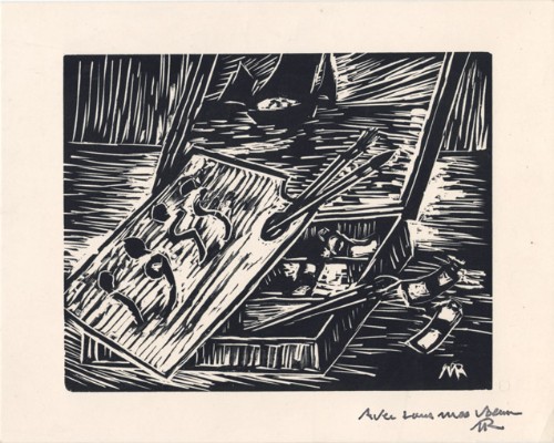
Roche, Marcel
Marcel Roche : carte de voeux pour 1955 et gravure originale
1955 Carte de voeux de Marcel Roche pour l'année 1955. Carte de 12 x 15 cm, portant une gravure sur bois en noir enrichie d'un mot autographe signé de l'artiste.
书商的参考编号 : 1477
|
|
|
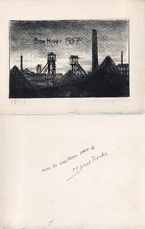
Roche, Marcel
Marcel Roche : carte de voeux pour 1957 et gravure originale
1957 Carte de voeux de Marcel Roche pour l'année 1957. 14,5 x 19 cm, 2 ff., en deuxième page une gravure en noir représentant un paysage minier, numérotée 58/75 et signée à la mine de plomb, en troisième page un envoi autographe signé à la plume.
书商的参考编号 : 1053
|
|
|
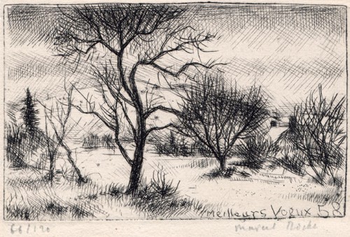
Roche, Marcel
Marcel Roche : carte de voeux pour 1958 et gravure originale
1958 Carte de voeux de Marcel Roche pour l'année 1958. 10 x 14,5 cm, 2 ff., en page 3 une gravure en noir, numérotée 66/120 et signée à la mine de plomb, le reste muet.
书商的参考编号 : 1476
|
|
|
Rochford, Noel
Landscapes of Corfu
No marks or inscriptions. Crease to lower corner of front cover, none to spine. A very clean very tight copy with bright unmarked boards and no bumping to corners. Large pull-out map in excellent condition. 128pp. Walking tours in Corfu plus car trips and picnic places.

|
|
|
Rochford, Noel
Landscapes of Lanzarote
No marks or inscriptions. No creasing to covers or to spine. A very clean very tight copy with bright unmarked boards, slight fading near spine and no bumping to corners. Large pull-out map in excellent condition. 70pp. Walking tours in Lanzarote plus car trips and picnic places.

|
|
|
Rocque John
A Plan of Rome… / La Topographia di Roma da G. B. Nolli… / Plan de Rome...
Pianta di Roma a proiezione verticale, orientata con il nord in alto.Incisa da R. Benning per il cartografo inglese John Rocque e basata sulla pianta di Giovan Battista Nolli del 1748."Come annunciato nel titolo (ripetuto anche in italiano e francese), si tratta di una diretta derivazione della pianta piccola del Nolli che l'autore ha voluto riportare nella scala in cui aveva già pubblicato la pianta della città di Londra. In basso a sinistra indice delle fabriche più ragguardevoli contenute nella pianta con 170 voci suddivise in sei colonne. In basso a destra dedica a Sir. Bouchier Wrey. Le emergenze architettoniche sono campite in nero ed il resto degli isolati a tratteggio diagonale. In basso a sinistra il nome dell'incisore R. Benning sc. La stessa pianta fu rstampata nel 1773 dal Sawyer" (cfr. Marigliani p. 274).Acquaforte, finemente colorata a mano, in buono stato di conservazione. Non comune. Vertical projection map of Rome, oriented with the north at the top.Published in 1750 by John Roque, from the earlier plan by Goivanni Battista Noli published in 1748 (These dates are printed on the map).As announced in the title (also repeated in Italian and French), this is a direct derivation of the small map of Nolli that the author wanted to bring back to the scale in which he had already published the map of the city of London. At the bottom left index of the most remarkable fabrications contained in the plan with 170 entries divided into six columns. Bottom right dedication to Sir. Bouchier Wrey. The architectural buildings are in black and the rest of the blocks are in diagonal hatching. Bottom left the name of the engraver R. Benning sc. The same plan was printed in 1773 by Sawyer (see Marigliani p. 274).Etching, finely colored by hand, in good condition. Not common. C. Marigliani, "Le Piante di Roma delle collezioni private", n. 192; Scaccia Scarafoni, "Le Piante di Roma", n. 230.

|
|
|
Roddy, H. J.
PHYSICAL & INDUSTRIAL GEOGRAPHY OF LANCASTER COUNTY, PENNSYLVANIA.
115 p. + Half tone photographic illustrations; + Folding Maps. Tall 8vo. Original cloth backed printed paper boards. Binding worn and slightly soiled. Scarce. PA 24 x2
|
|
|
Roderick MacFarquhar
The Forbidden City
No marks or inscriptions. A very clean very tight copy with bright unmarked boards and no bumping to corners. Dust jacket not price clipped or marked or torn or creased with very minor traces of storage. 172pp. With nearly 150 illustrations, many in colour, this account describes China's Forbidden City which only became accessible to all Chinese citizens after the 1911 revolution.

|
|
|
Roe F. Gordon historical text; Fen Emberton decorative maps
Britain's Birthright
London: P. R. Gawthorn Ltd. Post-war but not later than 1950 because of the Christmas 1950 inscription. A superb historical introduction to Britain famous and not-so-famous beauty spots with many colour photos. Spine is worn away at very bottom and top. Corners bumped. . Cloth. Good-/No Jacket. P. R. Gawthorn, Ltd. Hardcover
书商的参考编号 : 09580
|
|
|
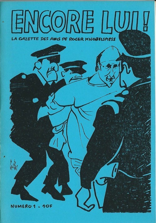
Roger Knobelspiess - Georges Blondeaux, dit Gébé - Jimmy Gladiator.
Encore Lui ! - La Gazette des amis de Roger Knobelspiess, n° 1. ( Dédicace autographe de Jimmy Gladiator sur carte postale )
Revue Encore lui ! La Gazette des amis de Roger Knobelspiess n° 1 de 1987. Plaquette in-8, agrafée, de 26 pages au format 15 x 21 cm. Couvertures illustrées par Gébé et Willem. Double page illustrée par Gébé. Directeur de la publication, Marie Rivière. Directeur empêché, Roger Knobelsiess. Rédacteur en chef Jimmy Gladiator. Textes de Roger Knobelsiess, Louis-Jean Calvet, Serge Quadruppani, Jimmy Gladiator, etc. Petit tirage. Edition originale enrichie d'une superbe dédicace autographe, signée, à Annie Gérardin, au verso d'une carte postale expédiée par Jimmy Gladiator de Grèce. Etat proche du neuf.
书商的参考编号 : 6305
|
|
|
Roger TREZEL
La clé du bridge
Fayard, Paris, 1969. Un volume in 8° broché de 168 pages. Bon état.
书商的参考编号 : 1038
|
|
|
Rogers, A.C. (Fred) (Signed)
Hiking - Mountain Biking & Adventure Trails of the Nanaimo-Extension Mines, Alberni Valley and Other Vancouver Island East Districts
78 pages. Documents over 40 hiking trails in the mid-island area. A wonderful reference including detailed descriptions and maps. Former owner's notes on back page. Moderate wear and light soiling. Author's signature upon title page. Book
|
|
|
ROGISSART Alexandre de
Rome
Veduta tratta dal "Les delices de l'Italie, contenant une description exacte du Païs, des principales villes, de toutesa les Antiquitez" edito, per la prima volta, a Leida nel 1706 da Pieter Vander Aa e successivamente ristampato a Parigi da Guillaume Cavelier.La maggior parte delle copie della seconda edizione reca nel frontespizio l'indicazione Compagnie des libraires, associazione di librai stampatori la cui composizione è variata negli anni ma di cui Guillaume Cavelier faceva parte.La guida, che sappiamo da Barbier I, 872 essere opera di Rogissart e dell'abate Havard, è impreziosita da 152 tavole,Incisione in rame, in buono stato di conservazione. Bibliografia Marigliani (2007): p. 259, n. 169. Panorama of Rome taken from "Les delices de l'Italie, contenant une description exacte du Païs, des principales villes, de toutesa les Antiquitez"published for the first time in Leiden in 1706 by Pieter Vander Aa and later reprinted in Paris by Guillaume Cavelier. Most of the copies of the second edition have on the title page the indication Compagnie des libraires, an association of booksellers and printers whose composition has varied over the years but to which Guillaume Cavelier belonged. The guide, which we know from Barbier I, 872 to be the work of Rogissart and Abbot Havard, is embellished with 152 plates Copper engraving, in good condition. Literature Marigliani (2007): p. 259, n. 169.

|
|
|
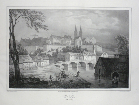
ROISSY;
ST. LO (Manche).
Paris Benard circa 1850 217 x 290 mm.
书商的参考编号 : LBW03d67
|
|
|
ROLAND (François)
Les Cartes anciennes de la Franche-Comté.. Etude historique et descriptive
Besançon, Dodivers, 1913-1924 3 parties en 3 vol. in-8, XV-150 pp., 94 pp. et 166 pp., 37 planches, broché. Petit manque au dos de la troisième partie.
书商的参考编号 : 216147
|
|
|
Roland ROSSI
COURS de CARTOMANCIE
Un ouvrage de 154 pages, format 140 x 205 mm, illustré, broché couverture couleurs, publié en 1998, Editions de Vecchi, bon état
书商的参考编号 : LFA-126713427
|
|
|
Rolfe, William J.; Crockett, William D.
A SATCHEL GUIDE TO EUROPE. THE FORTY-EIGHTH ANNUAL EDITION. WITH MAPS.
pp. cvi, 596, (32)[Advertisements] + numerous large folding maps. Endpapers advertising Thos. Cook & Sons Travel Organization. Inked ownership of Helen M. Hafer, Hanover, PA. Paris bookseller's label. 12mo. Original full red cloth binding, lettered in gold. Original dust jacket, chipped with small loss. Hardbound. Nice copy. TOURISM; CLOTHING; VOYAGE; PASSPORTS; CYCLING; AIR LINES; RAILWAYS; FOLDING MAPS; HAFER; HANOVER TRAVEL/1
|
|
|
Rolfe, William J.; Crockett, William D.
A SATCHEL GUIDE TO EUROPE. THE FORTY-NINTH ANNUAL EDITION. WITH MAPS.
pp. cvi, 596, (24)[Advertisements] + numerous large folding maps. Endpapers advertising Thos. Cook & Sons Travel Organization. Discrete stamped ownership of Mrs. Alvin F. Fix, York, Pa. on title page and elsewhere. Mr. Fix was a PA Democrat. Delegate to Democratic National Convention from Pennsylvania, 1936. 12mo. Original full red cloth binding. Hardbound. Nice copy. TRAVEL/1
|
|
|
Rollin
Atlas de géographie ancienne pour servir à l'intelligence des oeuvres de Rollin, gravé d'après les cartes originales de d'Anville
complet de ses 27 cartes et plans, gravés par Ambroise Tardieu Histoire ancienne; monde connu des anciens, Égypte et Libye, partie de l'Afrique ou les Carthaginois ont étendus leurs dominations, carte pour l'expédition d'Annibal et son passage en Italie, carte pour l'intelligence de l'histoire des Assyriens, des Babyloniens et des Perses, Grèce, grande Grèce & Sicile, Plan de Syracuse, carte pour l'expédition de Syrus et la retraite des dix mille Grecs, Grèce et pays septentrionaux jusqu'au Danube, Expédition d'Alexandre, Orient, Asie mineure. Histoire Romaine; environ de Rome, Rome ancienne, Italie, Italie ou l'on a tracé les voies Romaines, vue du combat naval d'Ecnome, expédition d'Annibal, Sicile, plan de Syracuse, Espagne, Grèce, Gaule cisalpine, Numidie, Province Romaine dans la Gaule, Gaule au temps de la conquête de César. vol in8, demi cuir 18x10, bel état de l'ensemble, cartes dépliées, de dimentions variables soit 43x39cm, 40x33cm, etc.. Paris, chez Carez, Thomine & Portic, 1819 ref/155
书商的参考编号 : CZC-11870

|
|
|
Rollin
Atlas de géographie ancienne pour servir à l'intelligence des oeuvres de Rollin, gravé d'après les cartes originales de d'Anville
complet de ses 27 cartes et plans, gravés par Ambroise Tardieu Histoire ancienne; monde connu des anciens, Égypte et Libye, partie de l'Afrique ou les Carthaginois ont étendus leurs dominations, carte pour l'expédition d'Annibal et son passage en Italie, carte pour l'intelligence de l'histoire des Assyriens, des Babyloniens et des Perses, Grèce, grande Grèce & Sicile, Plan de Syracuse, carte pour l'expédition de Syrus et la retraite des dix mille Grecs, Grèce et pays septentrionaux jusqu'au Danube, Expédition d'Alexandre, Orient, Asie mineure. Histoire Romaine; environ de Rome, Rome ancienne, Italie, Italie ou l'on a tracé les voies Romaines, vue du combat naval d'Ecnome, expédition d'Annibal, Sicile, plan de Syracuse, Espagne, Grèce, Gaule cisalpine, Numidie, Province Romaine dans la Gaule, Gaule au temps de la conquête de César. vol in8, demi cuir 18x10, bel état de l'ensemble, cartes dépliées, de dimentions variables soit 43x39cm, 40x33cm, etc.. Paris, chez Carez, Thomine & Portic, 1819 ref/155
书商的参考编号 : CZC-11870
|
|
|
ROLLIN et CREVIER
HISTOIRE ROMAINE DEPUIS LA FONDATION DE ROME JUSQU'A LA BATAILLE D'ACTIUM : C'est à dire jusqu'à la fin de la république
à Paris chez la veuve Etienne - 1752 8 volumes de format in-4 : 20 x 25,5 cm reliures plein veau marbré. Dos à 5 nerfs, caissons richement ornés à motifs dorés. Pièces de titre en maroquin rouge. Filets dorés sur les coupes. Tranches rouges, gardes marbrées, ex-libris de J.B Valentin. Tome 1 : éloge de M. Rollin, préface et avant propos 112 pages + 556 pages, 1 carte et un plan de Rome dépliants. Tome 2 : 56 pages + 600 pages, 2 cartes et 1 planche (plan du combat naval d'Ecnome)dépliantes. Tome 3 : 750 pages et 3 cartes et un plan dépliants. Tome 4 : 652 pages et 2 cartes dépliantes. Tome 5 : 672 pages. Tome 6 : 685 pages. Tome 7 : 684 pages, 1 carte dépliante. Tome 8 : 730 pages. Edition originale ,ornée de 10 cartes dépliantes et 2 plans dépliants.quelques coiffes abîmées (une est arrasée), traces de frottements sans conséquence (voir photos) rares rousseurs,quelques feuillets légèrement brunis,tous les cahiers sont bien alignés, mors solides peu usés.Bel exemplaire en reliure d'époque en bon état.
书商的参考编号 : 112
|
|
|
Rollings Charles/Buckham Robert M. illus/maps/Mathias Paul illus/maps
Wire and Worse: RAF Prisoners of War in Laufen Biberach Lubeck and Warburg 1940-42
Hersham: Ian Allan Publishing 2004. 1st printing. Fine/Fine dust jacket. 296 p. photos illus maps appendices biblio index 8vo; Ian Allan Publishing hardcover
书商的参考编号 : 61654 ???????? : 0711030502 9780711030503

|
|
|
Rollings Charles/Buckham Robert M. illus/maps
Wire and Walls: RAF Prisoners of War in Itzehoe Spangenberg and Thorn 1939-42
Hersham: Ian Allan Publishing 2003. 1st printing. Fine/Fine dust jacket. 264 p. photos illus maps appendices biblio index 8vo; Ian Allan Publishing hardcover
书商的参考编号 : 61657 ???????? : 0711029911 9780711029910

|
|
|
ROLMEDON, M.
Les Tours de Cartes les plus recreatifs et les plus surprenants.
in-12, 94 pp., figures, broche, couv. ill. Bel exemplaire, en grande partie non coupé. [CA26/4]
|
|
|
ROLMEDON, M.
Les Tours de Cartes les plus recreatifs et les plus surprenants.
Paris, Bornemann, 1951. in-12, 94 pp., figures, broche, couv. ill.
书商的参考编号 : 34606
|
|
|
ROMANO Pasqual
Tours de magie amusants.
Chantecler, 2002. 14 x 23, 115 pp., très nombreuses figures, cartonnage d'édition imprimé, très bon état.
书商的参考编号 : 36714
|
|
|
Ron Thornton
The River Tyne from Sea to Source
No marks or inscriptions. A very clean very tight copy with bright unmarked laminated boards, slight foxing to top of page edges and no bumping to corners. Dust jacket not price clipped or marked or torn with minor creasing to upper and lower edges. 160pp. A historical and background study of the River Tyne accompanied by the author's attractive paintings and illustrations. The direction of travel is from the harbour at Tynemouth upstream to both North and South Tyne sources. Beautifully illustrated.

|
|
|
RONCEREL (Michel).
Carte de voeux illustrée d'une gravure originale signée.
Paris Société des peintres-graveurs français 2002 1 vol. Broché Carte de voeux dépliante sur Arches illustrée d'une manière noire (21 x 15 cm) signée par Michel Roncerel. En parfait état.
书商的参考编号 : 109100
|
|
|
RONCEREL (Michel).
Carte de voeux illustrée d'une gravure originale signée.
Paris Société des peintres-graveurs français 2002 1 vol. Broché Carte de voeux dépliante sur Arches illustrée d'une manière noire (21 x 15 cm) signée par Michel Roncerel. En parfait état.
书商的参考编号 : 109100
|
|
|
Roomen Adrian van (Lovanio 1561 – Magonza 1615)
Roma
Pianta archeologica della città basata sul modello di Pirro Ligorio, pubblicata nel raro Parvum theatrum urbium sive urbium praecipuarum totius orbis brevis et methodica descriptio. Urbium praecipuarum totius orbis brevis et methodica descriptio [...]. di Adrian van Roomen, edita a Francoforte, Nicolaus Basse, 1595. Il Theatrum Urbium, stampato per la prima volta nel 1595 e quindi nel 1608, contiene 67 vedute silografiche di città. “Contains descriptions of Florida, New-France, New-Spain, Nova Galicia, Yucatan, Cuba, Brazil, Peru, etc." Also with views of Constantinople, Jerusalem, Genoa, London, Rostock, Rome, Vienna, Prague, Riga, Zurich, Genf, Bremen, Dresden, Geneva, Lubeck, Cologne, Leipzig, Mainz, Marburg, Munich, Nuremberg, Strasbourg, Trier, Ulm, Venice, Wittenberg and many others. (Sabin). Rara. Bibliografia Caldana, Roma Antica, Piante topografiche e vedute generali, p. 80, scheda I.11.Adams R 694. Bachmann 14. Muller 1376. Sabin 73000. Alden 595. Archaeological map of Rome based on the model of Pirro Ligorio (1561), published in the rare Parvum theatrum urbium sive urbium praecipuarum totius orbis brevis et methodica descriptio. Urbium praecipuarum totius orbis brevis et methodica descriptio [...]. by Adrian van Roomen, published in Frankfurt, Nicolaus Basse, 1595. The Theatrum Urbium, first printed in 1595 and again in 1608, contains 67 silographic views of cities. "Contains descriptions of Florida, New-France, New-Spain, Nova Galicia, Yucatan, Cuba, Brazil, Peru, etc." Also with views of Constantinople, Jerusalem, Genoa, London, Rostock, Rome, Vienna, Prague, Riga, Zurich, Genf, Bremen, Dresden, Geneva, Lubeck, Cologne, Leipzig, Mainz, Marburg, Munich, Nuremberg, Strasbourg, Trier, Ulm, Venice, Wittenberg and many others. (Sabin). Rare. Bibliography Caldana, Roma Antica, Piante topografiche e vedute generali, p. 80, scheda I.11.Adams R 694. Bachmann 14. Muller 1376. Sabin 73000. Alden 595.

|
|
|
Roost, I.B.:
Karte des Königreichs Bayern nach dem neusten Bestand, mit Angabe der Eisenbahnen und Dampfschiffahrten,,der Schiff und Floßbarkeit seiner Flüsse samt einem vergleichenden Höhen=Profile. 7. neu revidierte Ausgabe.
34 x 47 cm. Teilkolorierte Karte in 8 Segmenten, aufgezogen auf Leinen. In Orig.-Halbleinenumschlag, Der Einband berieben und beschabt. Landkarten de
|
|
|
ROQUE (Joseph). MANUSCRIT.
Télégraphes et paquebots.
[circa 1880]. 340 x 470 mm.
书商的参考编号 : LBW-4110

|
|
|
Roquefeuil, Camille de
Voyage Around the World 1816-1819 (English and French Edition)
A clean, unmarked book with a tight binding. Maroon leatherette cover with gilt lettering. Tears on edge worn dust jacket. Map endpapers. 144 pages. 6 1/4"w x 9 1/4"h.

|
|
|
ROSACCIO Giuseppe Pordenone circa 1530 – Venezia 1621
Carte dei quattro continenti
Suite raffigurante i 4 continenti, finemente incisi ad acquaforte e bulino, databili al 1590/95 ca. La carta dell’Asia è firmata in lastra, in basso a sinistra. Magnifiche prove, ricche di toni, impresse su carta vergata coeva con filigrana “ancora in un cerchio sormontato da fiore” con relativa contromarca (Briquet 571, Woodward 178), ampi margini, in perfetto stato di conservazioneLe mappe, secondo Philip Burden e Richard Betz, sono databili al 1605 e derivano chiaramente da quelle pubblicate nella Universale Fabrica del Mondo di Giovanni Lorenzo Anania, Venezia 1582. Si differenziano principalmente per dimensione e per scala di gradazione. Tuttavia ci permettiamo di discordare dalla datazione attribuita da Burden e Betz, ritenendo queste opere del Rosaccio databili al periodo 1590/95. Le mappe erano infatti accompagnate dalla carta del mondo che Rodney Shirley include tra quelle aggiunte nella nuova ristampa di The Mapping of the World, elencandone un solo esemplare conosciuto, che si trova nella Biblioteca Municipale di Grenoble. Shirley data la mappa all’ultimo decennio del XVI secolo. A conclusione dello studio su questo inusuale gruppo cartografico, possiamo evidenziare che questo set rappresenta una prima stesura del Rosaccio per la realizzazione delle carte successivamente inserite nella sua Geografia ed anche nelle Relationi Universali del Botero. Le opere, probabilmente realizzate in pochissimi esemplari, non furono mai inserite in nessuna pubblicazione, e si presentano su fogli intonsi, a pieni margini, stampate su carta con filigrana che il Briquet indica fabbricata a Verona intorno al 1583, ed il Woodward riscontra in altre mappe del periodo 1580 e 1594. Diverse sono anche le dimensioni delle lastre, ma questo probabilmente perché gli studiosi si sono trovati ad esaminare esemplari rifilati all’interno del rame.Giuseppe Rosaccio, medico e geografo, è noto per alcune opere geografiche e cosmografiche, che, sebbene di non gran mole, gli procurarono qualche fama e furono più volte ristampate. Tra esse il Teatro del Cielo e della Terra (Venezia 1595), il Mondo e le sue parti, cioè Europa, Affrica, Asia et America (Verona 1596), il Microcosmo (Firenze 1600), il Mondo elementare e celeste (Treviso 1604), il Discorso sulla nobiltà ed eccellenza della Terra (Firenze, s. a.). Egli curò anche un'edizione della Geografia di Tolomeo, stampata a Venezia nel 1599, corredandola con alcuni Discorsi e 42 tavole nuove. Set omogeneo, di straordinaria rarità. - EARLY ISSUE, UNRECORDED - Suite depicting the 4 continents, finely etched with etching and engraving, dating to 1590/95 approx. The map of Asia is signed in the plate, lower left. Magnificent proofs, rich tones, printed on contemporary laid paper with watermark "still in a circle surmounted by flower" with the countermark (Briquet 571, 178 Woodward), wide margins, in perfect conditionThe maps, according to Philip Burden and Richard Betz, can be dated back to 1605 and are clearly derived from that published in the Universale Fabrica del Mondo by Giovanni Lorenzo Anania, Venice 1582. They differ mainly in size and scale of gradation. However, we would disagree on the dating attributed by Burden and Betz, considering these works of Rosaccio dating from the period 1590/95. The maps were in fact accompanied by a map of the world that includes Rodney Shirley among those added to the new reissue of The Mapping of the World, listing only known specimen, which is located in the Municipal Library of Grenoble. Shirley dated the map at the last decade of the sixteenth century. At the conclusion of the study of this unusual maps, we can that describe this set is a first issue of Rosaccio’s maps later incorporated in his "Geographia" and also in the Relationi Universali by Botero. The works, probably made in a few examples, were never included in any publication, and are on uncut sheets, with full margins, printed on paper with a watermark that indicates Briquet manufactured in Verona around 1583, and Woodward found in other maps of the period 1580 to 1594. There are also different sizes of plates, but this is probably because scholars have found to examine specimens trimmed in copper.Homogeneous set of extraordinary rarity. Burden, The Mapping of North America, 149; Shirley, The Mapping of the World, 174A, Betz, The Mapping of Africa, 51; Briquet, Les Filigranes, 571. Dimensioni circa 210x260 ognuna

|
|
|
ROSACCIO Luigi (attivo a Firenze 1600-1620 circa)
Universale Descrittione di Tutto il Mondo del Ecc.te Gioseppe Rosaccio
Rara carta del mondo pubblicata separatamente da Luigi Rosaccio. La carta deriva dal planisfero murale di suo padre, Giuseppe Rosaccio (1597, Bifolco-Ronca n. 31). Rodney Shirley nota che “This curiously elaborate world map is to be found in a speculative world geography by Giuseppe Rosaccio... The right-hand hemisphere is surrounded by bands denoting the climates; the left-hand one by lively windheads and celestial constellations. In the centre cusp is a dyspeptic portrait of the young Duke Cosimo II de Medici, and in the spandels are circular representations of the four elements. The lower part of the engraving consists of a neatly engraved Ptolemaic map of the world and a set of spherical diagrams showing the zones, meridians, and geographical features”. La mappa è molto rara; questo è un esempio del secondo stato, con una barba aggiunta al ritratto di Cosimo de Medici. Priva di datazione, la carta risulta stampata a Firenze, dove la famiglia Rosaccio si era trasferita dopo il periodo veneziano, il 28 novembre 1606, ottenendo il privilegio della stampa per le proprie opere - vedi Casali, Il 'Teatro "del mondo. GR (ca 1530-1620) tra Firenze e Bologna, in L'Europa divisa e i nuovi mondi. Per Adriano Prosperi, II, a cura di M. Donattini - G. Marcocci - S. Pastore, Pisa 2011, p. 56. Aloisio, Aluigio, Alovigi o probabilmente Luigi Rosaccio, figlio del cosmografo Giuseppe Rosaccio, si formò a Firenze, forse con Antonio Tempesta, alla corte dei Medici. Fin dai primi anni Novanta, Giuseppe Rosaccio si stabilì a Firenze, dove il 13 luglio 1594 entrò nella compagnia dell'"Arte dei medici e speziali" (Casali, 2011, p. 56 e n. 15 p. 62) come venditore di libri, ponendosi al servizio e sotto la protezione del Granduca dal suo 'banco' aperto sulla prestigiosa Piazza del Palazzo e dedicando alcune delle sue opere più significative a Ferdinando, Cosimo II e alla granduchessa Cristina. Sempre nella città dei Medici, il 28 novembre 1606 ottenne il privilegio di stampare per le proprie opere (Casali, 2011, pp. 56 s.). Luigi Rosaccio si cimentò nell'arte incisoria, traducendo in stampa le numerose opere del padre. Nel 1610 realizzò il ciclo di illustrazioni incluse nella descrizione delle "Esequie d'Arrigo Quarto cristianissimo re di francia e di Navarra celebrate in Firenze dal Serenissimo DON COSIMO II Gran Duca di Toscana". Descritto da Giuliano Giraldi pubblicato a Firenze da Bartolomeo Sermartelli, importante come testimonianza visiva del complesso delle decorazioni più che per le qualità stilistiche e tecniche, non particolarmente brillanti. Sempre al periodo fiorentino sono legate le tre splendide carte geografiche raffiguranti l'Italia, una grande carta che precede l'Italia Nova di Giovanni Antonio Magini, la Toscana (la cosiddetta "Carta del Cavallo"), e il Piemonte. Bibliografia Shirley, The Mapping of The World, #268. Rare separately published map of the World by Luigi Rosaccio, after the of the largest World Map of his father Giuseppe Rosaccio (1597, Bifolco-Ronca n. 31). Rodney Shirley notes: “This curiously elaborate world map is to be found in a speculative world geography by Giuseppe Rosaccio... The right-hand hemisphere is surrounded by bands denoting the climates; the left-hand one by lively windheads and celestial constellations. In the centre cusp is a dyspeptic portrait of the young Duke Cosimo II de Medici, and in the spandels are circular representations of the four elements. The lower part of the engraving consists of a neatly engraved Ptolemaic map of the world and a set of spherical diagrams showing the zones, meridians, and geographical features” The map was engraved by Giuseppe’s relative Alovisio Rosaccio and is very scarce. This is an example of the second state, with a beard added to the portrait of de Medici. Without the data, the map is printed in Florence, where the Rosaccio family was transferred after the Venetian period, on 28 November 1606, obtaining the privilege of printing for their works - see Casali, Il 'Teatro "del mondo. GR (ca 1530-1620) tra Firenze e Bologna, in L’Europa divisa e i nuovi mondi. Per Adriano Prosperi, II, a cura di M. Donattini - G. Marcocci - S. Pastore, Pisa 2011, p. 56. Aloisio, Aluigio, Alovigi or probably Luigi Rosaccio, son of the cosmographer Giuseppe Rosaccio, was trained in Florence, perhaps with Antonio Tempesta, at the Medici court. Since the early nineties, Giuseppe Rosaccio settled in Florence, where on 13 July 1594 joined the company of “Arte dei medici e speziali (Art of doctors and apothecaries)” (Casali, 2011, p. 56 and n. 15 p. 62) as a seller of books, placing himself at the service and under the protection of the Grand Duke from his 'bench' opened on the prestigious Piazza del Palazzo and dedicating some of his most significant works to Ferdinando, Cosimo II and the Grand Duchess Cristina.. Still in the city of the Medici, on 28 November 1606 he obtained the privilege of printing for his own works (Casali, 2011, pp. 56 s.). Luigi Rosaccio tried his hand at engraving art, translating his father's numerous works into a print. In 1610 he made the cycle of illustrations included in the description of the “Esequie d’Arrigo Quarto cristianissimo re di francia e di Navarra celebrate in Firenze dal Serenissimo DON COSIMO II Gran Duca di Toscana”. Described by Giuliano Giraldi published in Florence by Bartolomeo Sermartelli, important as visual testimony of the complex of the decorations rather than for the stylistic and technical qualities, not particularly brilliant. Always in the Florentine period are related to the three wonderful geographic maps depicting Italy, a great map preceding the Italia Nova of Giovanni Antonio Magini, Tuscany (the so-called “Carta del Cavallo”), and Piedmont. Bibliografia Shirley, The Mapping of The World, #268.

|
|
|
ROSBO Patrick de
"Le tarot des comédiens; tome 2 : vingt-et-un récits et caractères inspirés du théâtre. Bibliothèque des signes."
Paris, Editions Clancier-Guénaud, 1987. 14 x 21, 158 pp., broché, bon état.
书商的参考编号 : 41300
|
|
|
ROSE DES VENTS
Rose des vents en quatre langues : Français, Italien, Latin, Espagnol.
1750 385 x 575 mm. une planche gravée, texte de part et d'autre d'une rose des vents aquarellée, ca. 1750
书商的参考编号 : 16605
|
|
|
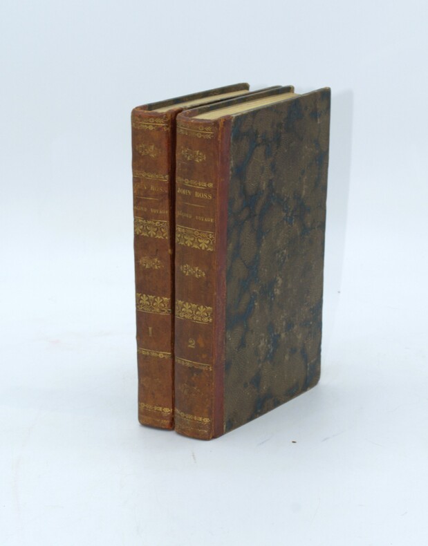
ROSS (Sir John), DEFAUCOMPRET (J.B., Trad.)
Relation du second voyage fait à la recherche d'un passage au Nord-Ouest par Sir John ROSS capitaine de la marine royale, chevalier de l'ordre du Bain... et de sa résidence dans les régions arctiques pendant les années 1829 à 1833 ; contenant le rapport du capitaine de la marine royale Sir Clarck ROSS, et les observations relatives à la découverte du Pôle Nord, ouvrage traduit sous les yeux de l'auteur par A.-J.B. DEFAUCOMPRET.
Paris, chez Bellizard, Barthés, Dufour et Lowell ,1835, 2 volumes in-8, lxi-1fnch-456pp., 2ffnch-544pp., relié demi basane époque, dos lisse avec auteur et titre, tranches jaunes, petits frottements, coins usés, petites rousseurs carte et portrait.
书商的参考编号 : PHO-1525
|
|
|
Ross, David
World Atlas
12mo, 64 pages, over 35 colour maps. eng
|
|
|
Ross, Zoe
Insight Guide : Amsterdam
Book in mint condition. 289pp. Everything you'll ever need in a guidebook which vividly conveys a sense of everyday life.

|
|
|
ROSSEL A- VIDAL J
DECOUVERTE DE L'AUVERGNE
Hier et demain ,1972, gr in folio en feuilles sous emboitage rouge éditeur. Tirage limité à 799 ex numérotés. 47 planches dont de nombreuses couleurs. Reproduction de grande qualité de cartes,lithos ,gravures ,pour la plupart introuvables,du XVè au XIXè siècle.
书商的参考编号 : ML171
|
|
|
ROSSEL André et VIDAL Jean
Découverte du Dauphiné
1973 Editions Hier et Demain, , 1973. In-plano, en feuilles, sous emboîtage toile jaune éditeur, texte liminaire et 42 planches. en noir et couleurs Ce tirage a ete limite a 799 exemplaires exemplaire Présentation du professeur Robert Bonecque. Les documents reproduits proviennent notamment du département des cartes et plans de la Bibliothéque Nationale du Cabinet des Estampes des musées et Bibliothéques locaux et de collections priveés sous emboitage recouvert de tissus jaune original 57 cm. parfait etat
书商的参考编号 : 3525
|
|
|
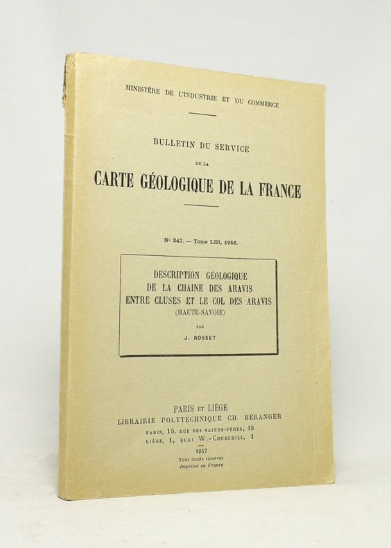
ROSSET J:
Bulletin du service de la carte géologique de la France. Description géologique de la chaîne des Aravis entre Cluses et le col des Aravis (Haute-Savoie).
Paris et Liège, Librairie polytechnique Ch. Béranger, 1957. In-8 broché de 147 pages, couverture imprimée en noir (défraîchie).
书商的参考编号 : 16744
|
|
|
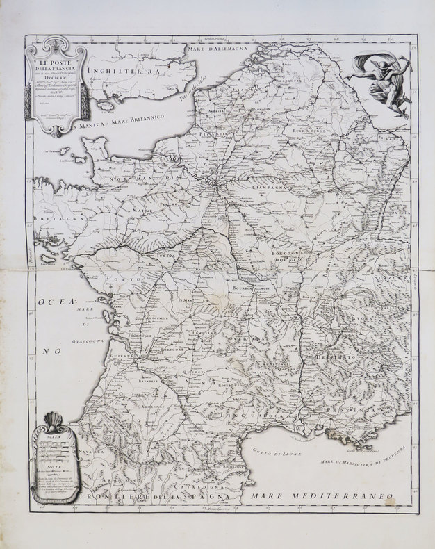
ROSSI (Domenico de).
[POSTES] Le Poste della Francia con le sue strade principali.
Roma, Domenico de Rossi, 1697. 663 x 542 mm.
书商的参考编号 : LBW-3567
|
|
|
Rossiter Richard Text photos artwork maps by
Teton Classics: Selected Climbs in Grand Teton National Park
Evergreen CO.: Chockstone Press Inc. 1991. Hard cover. Very good. Light soiling. 1 Durable sealed paper color photo illustrated. Curved outside corners. 96p. Audience: General/trade. Guidebook: 9 climbing destinations w/ maps descriptions pictures. Chockstone Press Inc. hardcover
书商的参考编号 : Alibris.RT0060008036 ???????? : 0934641137 9780934641135

|
|
|
ROTE (Robert de).-
Manuel des systèmes modernes au Bridge. Leur raison d'etre. Leur explication facile. Le culbertson, le vanderbilt et les autres.
Tunrhout, Brepols, sans date, in 12 relié pleine percaline verte de l'éditeur, 189 pages ; légère décoloration de la toile en pied du plat supérieur.
书商的参考编号 : 51100
|
|
|
 ?????????
 ?????PDF???
 RSS feed


