|
Swell Maps
International Rescue Vinyl
Alive 2009-03-17. Vinyl. Used:Good. Alive unknown
Riferimento per il libraio : DADAXB000OYAV8I
|
|
|
Swell Maps
Jane From Occupied Europe
Secretly Canadian 2011-12-06. Vinyl. Used:Good. Secretly Canadian unknown
Riferimento per il libraio : DADAXB005VROF30
|
|
|
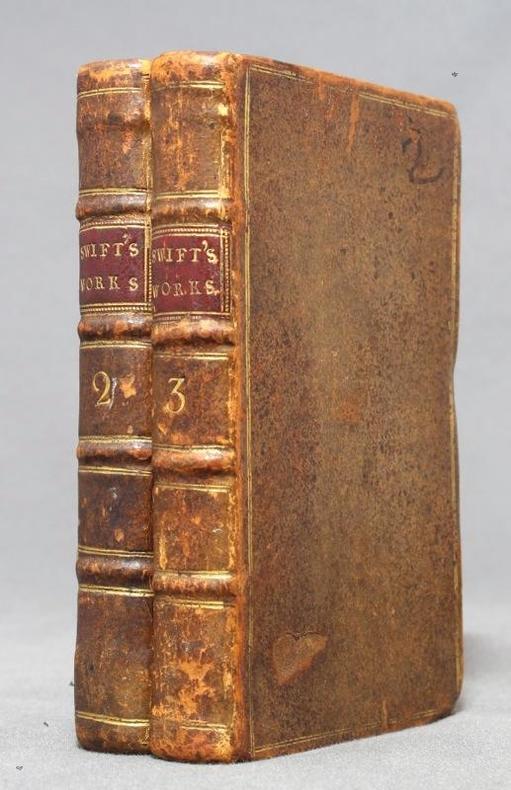
SWIFT Jonathan:
Capt. Lemuel Gulliver's Travels into several remote nations of the world.
London, C. Bathurst, coll. The works of Dr. Jonathan Swift II et III, 1751. 2 volumes in-16 de XXIV-224-[4] et X-244 pages, plein veau brun, dos à 4 nerfs ornés d'encadrement, titre et tomaison dorés, pièces de titre bordeaux, double filet doré encadrant les plats, roulette à froid sur les coupes, tranches mouchetées.
Riferimento per il libraio : 12758
|
|
|
Swinton, William.
A CONDENSED SCHOOL HISTORY OF THE UNITED STATES, Constructed for Definite Results in Recitation and Containing a New Method of Topical Reviews. With Colored Maps and many Illustrations. Revised Edition.
pp. viii, 334, (2) [Publisher's catalogue] + Five color maps. Numerous text drawings and maps. Slightly age stained. Anna Herdon's copy. Front fly leaf torn with loss. 12mo. Original leather spine over cloth covered boards. Spine lettered in gold and embossed with figure of Phoenix raising. Front board portrait of Washington. Cloth boards faded, stained and worn. Extremities worn with some loss. Hardbound. PA71 FRONT
|
|
|
Sylvestre Françoise
Comment cuisiner le chevreau...
Production Marie Sylvestre Cartes sous boîte In-12 (10,2 x 15,2 cm), cartes sous chemise portant chacune une recette ; mors frottés, par ailleurs bel état. Livraison a domicile (La Poste) ou en Mondial Relay sur simple demande.
Riferimento per il libraio : lu2318
|
|
|
SYLVAIN Gérard, KOTEK Joël
LA CARTE POSTALE ANTISEMITE
Berg international, Paris, 2005
Riferimento per il libraio : 51028
|
|
|
SYNDICAT GENERAL DES ALPES FRANCAISES
Dauphin?-Savoie. Carte couleurs au 1/400 000?me. Sans date.
1 feuille. 47x60 cm. Plis r?par?s.
|
|
|
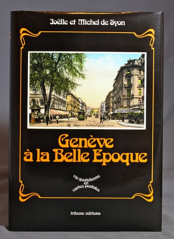
SYON Joelle et Michel de:
Genève à la Belle Epoque.
Genève, Tribune éditions, 1979. In-4 de [12]-174-[10] pages, pleine toile bouton d'or avec titre doré au dos, jaquette photographique.
Riferimento per il libraio : 13283
|
|
|
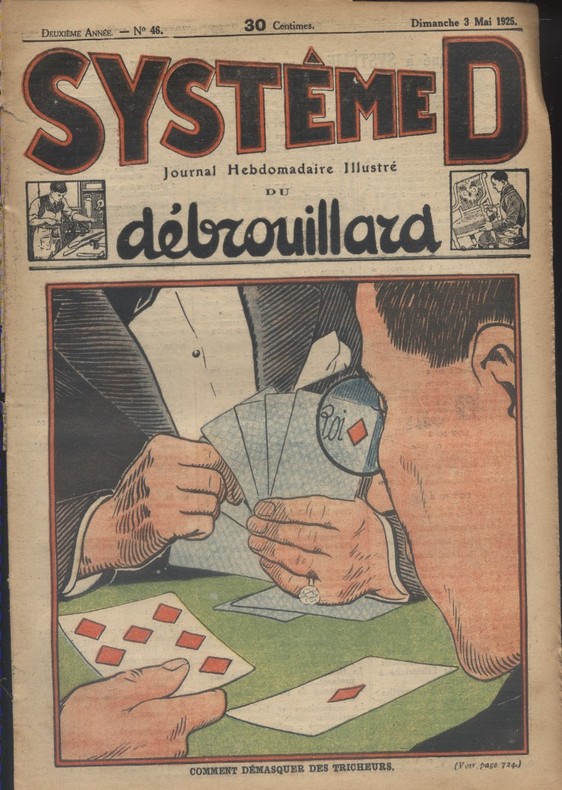
SYSTEME D -
Journal hebdomadaire illustré du débrouillard. N° 46. En couverture : Comment démasquer les tricheurs.
Couverture souple. Revue 19 x 27 cm. 16 pages. Papier bruni. Extraite de reliure.
Riferimento per il libraio : 128651
|
|
|
Sze-tsen Hu
Introduction to General Topology.
San Francisco/London, Holden-Day (Holden-Day Series in Mathematics), 1966. X, 230 S. (24 cm) Leinen / gebundene Ausgabe
Riferimento per il libraio : 72716
|
|
|
Sze-tsen Hu
Introduction to General Topology.
San Francisco/London, Holden-Day (Holden-Day Series in Mathematics), 1966. X, 230 S. (24 cm) Leinen / gebundene Ausgabe
Riferimento per il libraio : 72719
|
|
|
SÄUBERLIN (Albert) & PFEIFFER (Georges).
[SUISSE] Le 66. Jeu d'Histoire suisse.
Lausanne, Éditions "Spes", [vers 1940]. Lithographie en couleurs de 365 x 472 mm, montée sur carton, et se pliant en quatre avec une fente pour faciliter le pliage (montage de l'éditeur).
Riferimento per il libraio : LBW-8578

|
|
|
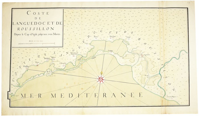
SÈTE. MANUSCRIT.
Coste de Languedoc et Roussillon, depuis le cap d'Agde jusqu'aux Trois Maries.
[circa 1750]. En deux feuilles jointes de 460 x 835 mm.
Riferimento per il libraio : LBW-490
|
|
|
SØKORT - SØKORTARCHIVET (UDG.).
Store Belt (Samsøe Beltet). 1832. Rettet til 1848.
(København), KDSK (Kgl. Danske Søkort Archiv), 1848. Kobberstukket søkort (106 x 63 cm.). I original opsætning på lærred og monteret i 27 sektioner (9 x 3). Foldet og opbevaret i det originale marmorerede foderal. Ren og velbevaret.
Riferimento per il libraio : 57654
|
|
|
SØKORT - SØKORTARCHIVET (UDG.).
Store Belt (Samsøe Beltet). 1832. Rettet til 1848.
(København), KDSK (Kgl. Danske Søkort Archiv), 1848. Kobberstukket søkort (106 x 63 cm.). I original opsætning på lærred og monteret i 27 sektioner (9 x 3). Foldet og opbevaret i det originale marmorerede foderal. Ren og velbevaret.
|
|
|
T G H James with maps by Denys Baker
EGYPT REVEALED Artist-Travellers in an Antique Land
The Folio Society London 1997 Hardcover 7�" x 10�" 19�cms x 26cms with illustrated board covers lacking slipcase Book in AS NEW condition This book deals almost exclusively with the British contribution to the recording of ancient Egyptian civilisation over almost two centuries. It tells a story of determined labour undertaken often in difficuly and dangerous circumstances. It emphasises the little-known amateur and professional workers who laboured on the recording of monuments and the copying of inscriptions from which a comprehensive picture has emerged. Book includes over 100 illustrations consisting of many colour illustrations maps and b&w photographs. The Folio Society, London hardcover
Riferimento per il libraio : 42118
|
|
|
T. Et al. Clark; Illustrator Charts b & w Photo Maps
THE PRAIRIE DOG ECOSYSTEM: MANAGING FOR BIOLOGICAL DIVERSITY
Montana Bureau of Land Management 1989. Paperback. Very Good. SCARCE LARGE & SLENDER SOFTCOVER BOOK WITH ONLY A SINGLE INSTTUTIONAL STICKER TO FRONT COVER. NO WRITING OR MARKINGS IN TEXT. LIGHT WEAR TO COVER. A CLEAN & SOLID COPY. Montana Bureau of Land Management paperback
Riferimento per il libraio : SKU-44986
|
|
|
T. W. Manson. With maps Unknown Binding
A Companion to the Bible. Edited
T & T Clark. 1943 second impression pub T & T Clark hardback without dj; owner's note inside front cover else clean copy; blue board covers bright slight edge wear; UK dealer . Good. Hardback. 1943. T & T Clark hardcover
Riferimento per il libraio : 50R13
|
|
|
Taaffe Robert N. Maps by Robert C. Kingsbury
An Atlas of Soviet Affairs
NY: Frederick A. Praeger 1966. Trade paperback. Paper yellowed covers lightly rubbed: VG. small 8vo. numerous maps in black & white by Robert C. Kingsbury. 3rd Prtg. Frederick A. Praeger paperback
Riferimento per il libraio : 9574020402
|
|
|
Taaffe Robert N. Maps by Robert C. Kingsbury
An Atlas of Soviet Affairs
NY: Frederick A. Praeger 1966. yellow cloth. Ex-library o/w VG in VG dj. small 8vo. numerous maps in black & white by Robert C. Kingsbury. 3rd Prtg. Frederick A. Praeger hardcover
Riferimento per il libraio : 2294050599
|
|
|
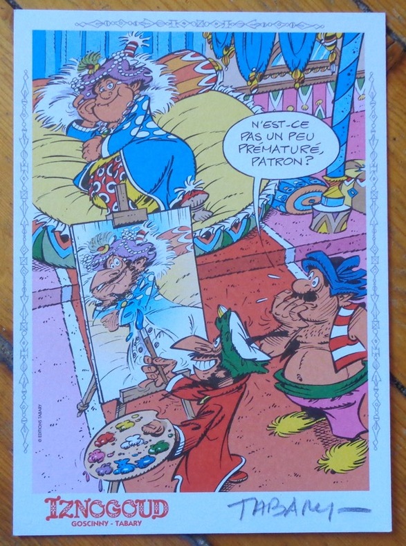
Tabary:
Iznogoud.
Editions Tabary. Ex-libris polychrome au format 15 x 21 cm.
Riferimento per il libraio : 8568
|
|
|
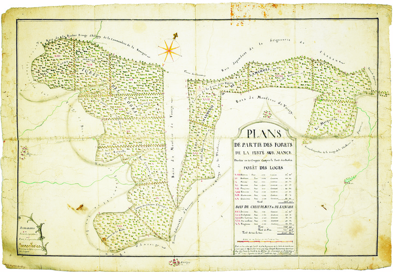
TABOUREUX (Joseph). MANUSCRIT.
Plans de partie des forêts de La Ferté sur Mance, divisées en 20 couppes compris la forêt des Brosses.
1747. 505 x 772 mm.
Riferimento per il libraio : LBW-4094
|
|
|
TACHARD (Guy).
[SIAM/THAÏLANDE] Carte marine depuis Suratte jusqu'au Détroit de Malaca. Dressée par le R.P. Tachard de la Compagnie de Jésus, missionaire et mathématicien du roy dans les Indes.
Paris, J.B. Nolin, 1742. 480 x 731 mm.
Riferimento per il libraio : LBW-8191

|
|
|
Tadda, Ted; Hawthorn, A.; Harrington, R.; East, B.; Robinson, J.; Price, A.; Nute, G.; Banfield, A.; Carruthers, J.
The Beaver, Magazine of the North, March 1952, Outfit 282 - Totem Pole Carver Mungo Martin / Changing the Arctic Maps, Part II
50 pages. Many reproductions of black and white photos. Printed upon glossy stock. Features: Kwakiutl Totem Pole Carver Mungo Martin; The Cheerful Eskimo - photo-portraits by Richard Harrington; Ballet of the Brushlands - courtship dance of the sharptail grouse; Bankers from Portugal - Photo-illustrated article on Portuguese activity on the banks off Newfoundland; Changing the Arctic Maps - II - Dr. J. Lewis Robinson discusses the mainland the the islands south of of 75 degrees North Latitude; Mackenzie River Sketch Book; Border Chieftain - Dr. John McLoughlin, of Oregon fame, spent almost 20 years fur trading along the present Minnesota-Ontario border; The Wolf and the Caribou; Land of the Ojibway; Nice photo inside back cover shows Fort Garry Coffee being cooked on a rock; Nice colour ad for Hudson's Bay Point Blankets on back cover. Clean and unmarked with moderate wear. A sound vintage copy. Book

|
|
|
Taffe Robert N. with Robert C. Kingsbury Maps
An Atlas of Soviet Affairs
New York NY: Frederick A. Praeger 1965. First Edition. Hardcover. Good. Size=5.5"x8". 75 Maps & Charts. full book description Frederick A. Praeger New York NY 1965. 1st Edition Good Hard Cover no Dust Jacket. Size=5.5"x8" 143ppIndex. 75 Maps & Charts. EX-LIBRARY copy!! Usual stamps etc. rear fore-endpaper is removed & pages browned at edge areas o.w. clean & tight. Soviet Affairs; Atlases; Soviet Industry; Soviet Economy SELLING WORLDWIDE SINCE 1987. WE ALWAYS PACK WITH GREAT CARE! Frederick A. Praeger hardcover
Riferimento per il libraio : CONROY101225I
|
|
|
Tait, Malcolm
London's Royal Parks
No marks or inscriptions. A very clean very tight copy with bright unmarked boards, very slight rub to upper corner of front end paper and no bumping to corners. Dust jacket not price clipped or marked or torn or creased with traces of storage and handling. 180pp.

|
|
|
TALABOT (Paulin).
[CANAL de BEAUCAIRE] Plan général des canaux concédés à la compagnie des canaux de Beaucaire et d'Aiguesmortes et des propriétés qui lui appartiennent.
Avril 1833. En deux feuilles coupées en 19 sections montées sur toile et repliées, formant une carte de 0,45 x 1,18 m ; étiquette au dos portant le titre et la date en manuscrit.
Riferimento per il libraio : LBW-8327

|
|
|
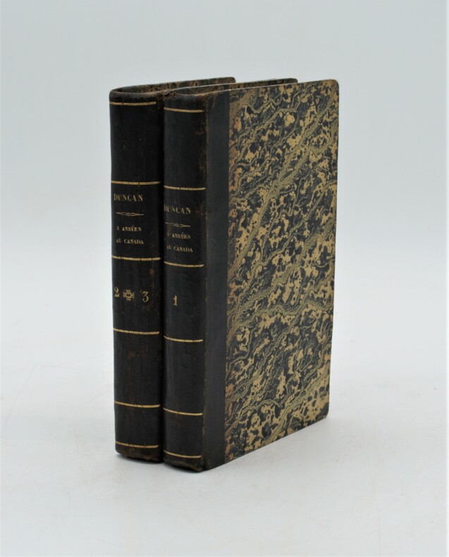
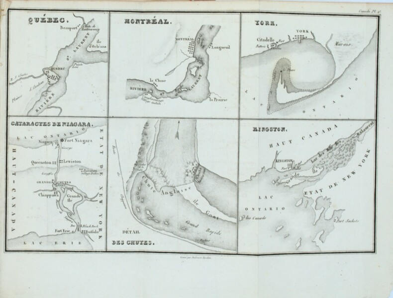
TALBOT , Edward Allen
Cinq années de séjour au Canada. Traduit de l'anglais, par M***. Suivies d'un extrait du voyage de M. J. M. Duncan en 1818 et 1819, traduit de l'anglais, par M. Eyriès.
1833 ,Paris, à la librairie centrale, 3 tomes en 2 volumes in-8 (130x200), demi-veau époque, dos lisse avec titre et tomaison , tranches marbrées . xiij, 1, 364 - 2, 323 -2, 175 .Elle est illustrée de 2 cartes, d'un plan dépliants et de 4 gravures , les cartes par Ambroise Tardieu. Rousseurs, trace de mouillages sur quelques pages , tâche au titre .
Riferimento per il libraio : PHO-1111
|
|
|
TALBOT , Edward Allen
Cinq années de séjour au Canada. Traduit de l'anglais, par M***. Suivies d'un extrait du voyage de M. J. M. Duncan en 1818 et 1819, traduit de l'anglais, par M. Eyriès.
Paris, chez Boulland & Compagnie,1825, 3 volumes in-8 (130x200), couverture d’attente rose ,étiquette avec auteur et titre au dos ,iii-xiij, 1, 364pp., 323pp. ,175pp. .Elle est illustrée 6 gravures et de 2 cartes et d'un plan dépliants (détachés ) , les cartes par Ambroise Tardieu , cartes coupées court avec manque de texte .
Riferimento per il libraio : PHO-1410
|
|
|
Talbot, Rob & Whiteman, Robin
The Peak District
No marks or inscriptions. No creasing to covers or to spine. A very clean very tight copy with bright unmarked boards and no bumping to corners. 160pp. Derbyshire's Peak District described and depicted in beautiful colour photographs. In the Country Series.

|
|
|
TALLEMANT DES REAUX.
Les Historiettes. Troisième édition entièrement revue sur le manuscrit original et disposée dans un nouvel ordre par MM. Monmerqué et Paulin Paris.
Paris, J. Techener, 1854-1860. 9 volumes in-8, demi-chagrin cerise à coins, dos à 5 nerfs filetés, caissons, tomaisons, titres et têtes dorées. (reliure signée Petit succ de Simier). Première édition complète et définitive de ces Célèbres Mémoires qui constituent le tableau le plus spirituel du 17è siècle. Tallemant des Réaux épousa sa riche cousine qui l'introduisit dans les salons de l'hôtel de Rambouillet, où il put observer à son aise les moeurs de la haute société. Malgré les descriptions parfois sans concessions de ses contemporains, Tallemant des Reaux fut considéré par tous comme un prosateur de grand talent. Le témoignage de Tallemant sur son époque est d'une grande valeur historique, et son ouvrage au style alerte et coloré est sans égal. On a pu écrire : "A le lire, on s'instruira toujours et on ne s'ennuiera jamais". Avec l'ex-libris de JULES JANIN. Bel exemplaire.
|
|
|
TAN ET GARONNE
Carte d?partementale. Sans date.
1 feuille 50x65 cm repli?e.
|
|
|
Tannenzapf William & Renate Krakauer; Sir Matin Gilbert Maps
Memories from the Abyss / but I Had a Happy Childhood
Second Story Press. Fine. 2009. First Edition. Softcover. 1897470061 . Stiff unmarked book in crisp covers; about new. ; Azrieli Series of Holocaust Survivor Memoirs; 8.90 X 6 X 0.50 inches; 176 pages . Second Story Press paperback
Riferimento per il libraio : 49800 ISBN : 1897470061 9781897470060

|
|
|
TARIDE (Cartes)
"Plan-guide de Paris, répertoire des rues, métropolitain; Renseignements indispensables : Ministères, Ambassades et Consulats, Préfectures, Mairies, Police, Hôpitaux, Postes et Télégraphes, Monuments, Musées, Parc, Cinémas, Théâtres et Attractions, etc."
Paris, Cartes Taride, 1949. 11 x 14, 224 pp., 22 cartes dépliantes en couleurs, reliure skivertex rouge, bon état.
Riferimento per il libraio : 101.544
|
|
|
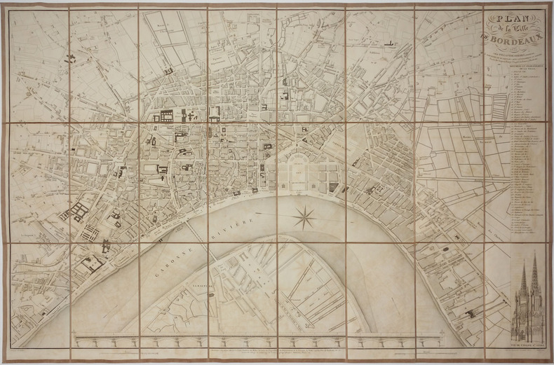
TARDIEU (Jean-Baptiste).
[BORDEAUX] Plan de la ville de Bordeaux.
Bordeaux, Fillastre Frères, 1853. En 24 sections montées sur toile et pliées, formant un plan de 600 x 915 mm ; sous étui de l'éditeur.
Riferimento per il libraio : LBW-2771
|
|
|
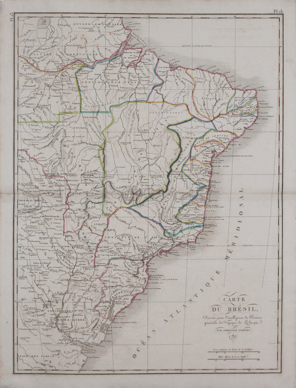
TARDIEU (Ambroise).
[BRÉSIL] Carte du Brésil.
1821 [1825]. 538 x 402 mm.
Riferimento per il libraio : LBW-3229
|
|
|
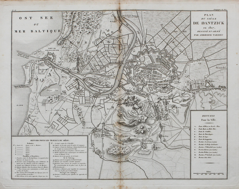
TARDIEU (Ambroise).
[GDANSK] Plan du siège de Dantzick en 1807.
[circa 1820]. 367 x 462 mm.
Riferimento per il libraio : LBW-4518
|
|
|
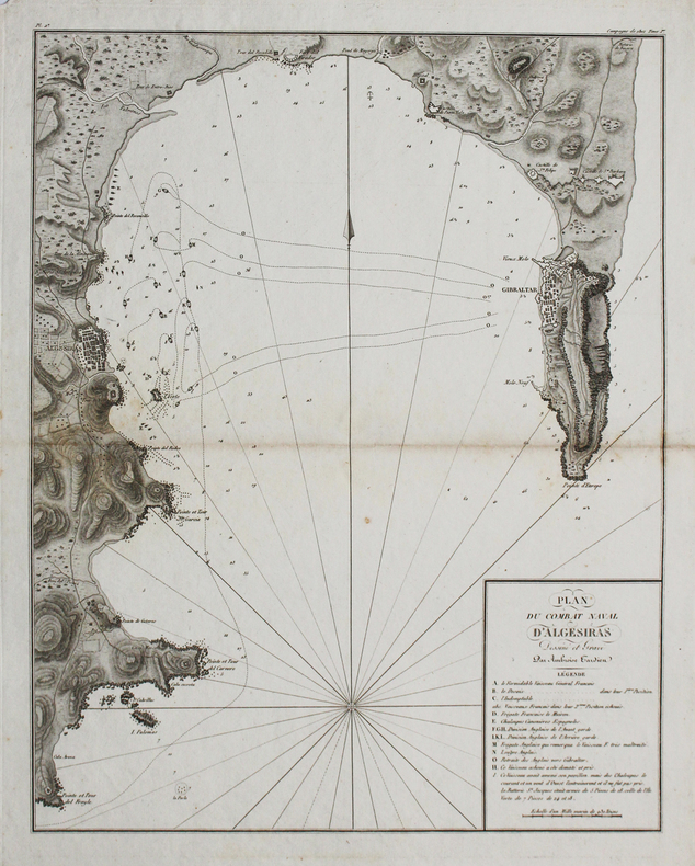
TARDIEU (Ambroise).
[GIBRALTAR] Plan du combat naval d'Algésiras.
[circa 1820]. 460 x 366 mm.
Riferimento per il libraio : LBW-4526
|
|
|
TARDIEU (Pierre François).
[KRONSTADT] Plan de Kronstadt.
[1794]. 216 x 308 mm.
Riferimento per il libraio : LBW002c2
|
|
|
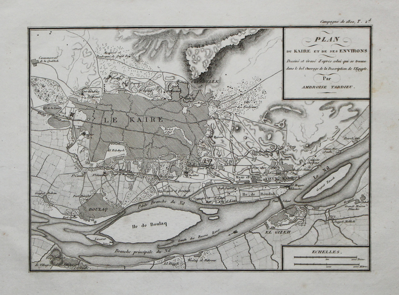
TARDIEU (Ambroise).
[LE CAIRE] Plan du Kaire et de ses environs.
[circa 1820]. 176 x 252 mm.
Riferimento per il libraio : LBW-4497
|
|
|
TARDIEU (Nicolas Henri) & MENESTRIER (Claude-François).
[LYONNAIS] Carte de l'ancienne ville de Lyon.
[1696]. En 2 feuilles pouvant être jointes et former un plan d'environ 660 x 860 mm.
Riferimento per il libraio : LBW00291

|
|
|
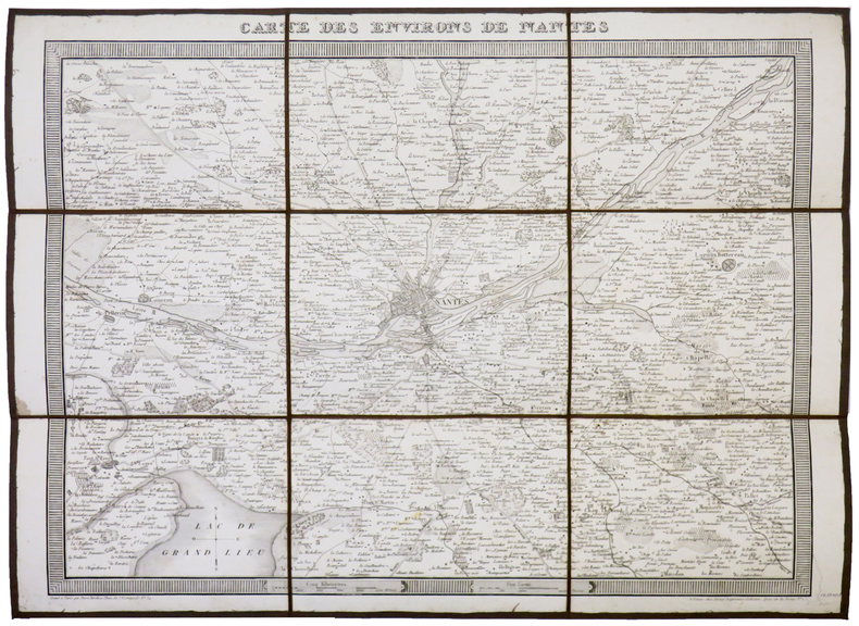
TARDIEU (Pierre François).
[NANTES] Carte des environs de Nantes.
Nantes, Forest, [circa 1820]. En 9 sections montées sur toile et pliées, formant une carte de 354 x 479 mm.
Riferimento per il libraio : LBW-5349
|
|
|
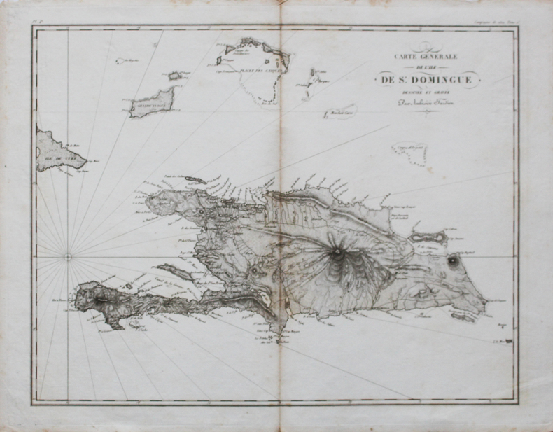
TARDIEU (Ambroise).
[SAINT-DOMINGUE] Carte générale de l'île de St. Domingue.
[circa 1820]. 364 x 461 mm.
Riferimento per il libraio : LBW-4463
|
|
|
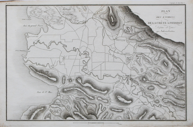
TARDIEU (Ambroise).
[SAINT-DOMINGUE] Plan des environs de la Crête à Pierrot.
[circa 1820]. 244 x 371 mm.
Riferimento per il libraio : LBW-4503
|
|
|
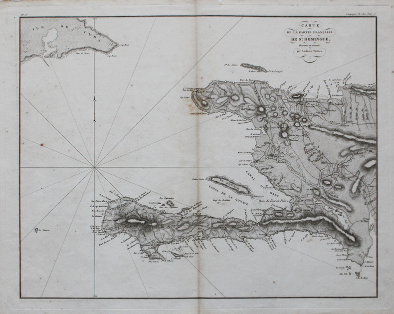
TARDIEU (Ambroise).
[SAINT-DOMINGUE] Carte de la partie française de St. Domingue.
[circa 1820]. 369 x 464 mm.
Riferimento per il libraio : LBW-4507
|
|
|
TARDIEU (Ambroise).
[SAINT-LAURENT-du-VAR] Plan de la défense du pont du Var par le Corps d'Armée aux ordres du lieutenant général Suchet.
[circa 1820]. 148 x 196 mm.
Riferimento per il libraio : LBW-4509

|
|
|
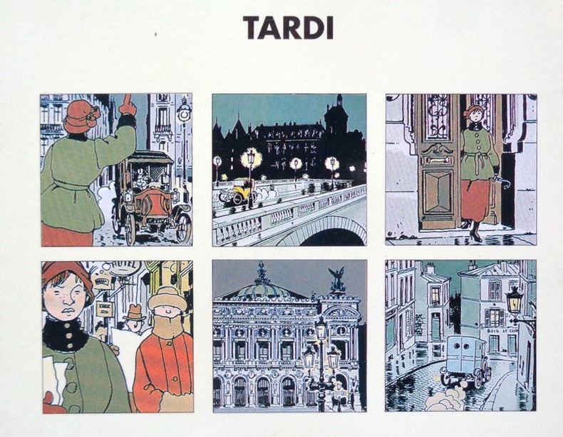
Tardi Jacques:
Adèle Blanc-Sec - Tous des monstres.
Casterman, 1995. 6 cartes doubles avec enveloppes, sous pochette illustrée.
Riferimento per il libraio : 6237
|
|
|
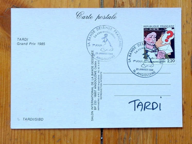
Tardi Jacques:
Angoulême 13 - Un héros peut en chacher un autre.
Angoulême, Salon international de la Bande Dessinée, 29 janvier 1988. Carte postale à l'état de neuf, signée par Tardi. Timbre Adèle Blanc Sec, oblitéré au jour d'émission.
Riferimento per il libraio : 5336
|
|
|
TARDIEU (Pierre François).
Carte de la mer d'Azof et d'une partie de la mer Noire levée en 1774 par Monsieur Kinsbergen capitaine de haut-bord de S.M. Impériale de toutes les Russies.
[1794]. 210 x 450 mm.
Riferimento per il libraio : LBW-1158

|
|
|
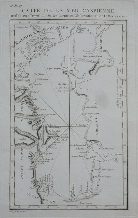
TARDIEU (Pierre François).
Carte de la mer Caspienne dressée en 7bre 1776 d'après les dernières observations par D. Guldenstaedt.
[1794]. 260 x 153 mm.
Riferimento per il libraio : LBW-1159
|
|
 Ricevere i risultati per e-mail
 Scaricare i risultati in PDF
 RSS feed


