|
US Geological Survey
Blandford Massachusetts 1:25000 Scale Metric Topographic Map
Washington DC: US Geological Survey 1987. map. Very Good/No Jacket. 61 x 102 cm. folds to 21 x 11 cm. Cover shows bookstore label and a small area of sticker damage otherwise unworn US Geological Survey unknown
书商的参考编号 : 200202

|
|
|
US NAVY, Hydrographic Office
ATLAS OF PILOT CHARTS, ATLANTIC OCEAN. Includes... The Pilot Charts of the North Atlantic and South Atlantic Ocean, and Central American Water. All together 28 maps, january 1951.ATLAS DES ROUTES MARITIMES (CARTES MARINES) DE L'OCEAN ATLANTIQUE)
1951 Hydrographic Office, Washington, 1951. One volume in plano, 66 x 51 cm, paper back, 28 maps. Some foxing on the cover, good inside.
书商的参考编号 : 2429
|
|
|
US. Executive Messages Maps and Views. U. S.
MAPS AND VIEWS TO ACCOMPANY MESSAGES AND DOCUMENTS. 1854-5. Message from the President of the United States to the Two Houses of Congress at the Commencement of the Second Session of the Thirty-third Congress. Part III Illustrations Belonging to Reports
A.O.P. Nicholson Printer Washington D.C.: . 1854 2 pp. Title-page with list of contents on the verso 45 maps and plans of various sizes some quite large most folding. Some damp stain and foxing but nothing too substantial except to the endpapers. Original full black cloth binding stamped in blind and lettered in gold gilt. Lightly worn. 4to. 300mm. These maps and plans illustrate the Reports of: the Commissioner of the General Land Office 8: Commissioner of Public Buildings 1-4; National Hospital for the Insane 1; Colonel of Topographical Engineers 31; and the Report of the Chief of Ordnance and Hydrography 1 Officers Quarters at Annapolis. Significant regions covered include parts of: Kansas; Nebraska; Arkansas; Florida; Michigan; Iowa; California; Minnesota; Wisconsin; Ohio; District of Columbia; New York; as well as a Topographical Map of a portion of the Isthmus of Darien in site of proposed inter-oceanic navigation canal. These reports were apparently an adjunct to the MAPS AND CHARTS OF THE UNITED STATES COAST SURVEY. A wonderful addition to any collection of U.S. Maps. . PRICE JUST REDUCED! W155 CTR. Full Cloth. Hardcover. Very Good. A.O.P. Nicholson, Printer, Washington [D.C.]: . hardcover
书商的参考编号 : 182A61
|
|
|
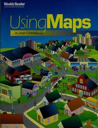
Using Maps in Your Neighborhood: Grade 2 Weekly Reader Reader
Using Maps in Your Neighborhood: Grade 2 Weekly
Good. Upper right corner of entire booklet lightly creased. Otherwise clean solid and unmarked. Light general edge wear. unknown
书商的参考编号 : MU-AI5H-VE33 ???????? : 0837414512 9780837414515
|
|
|
USSR Soviet Union Communist Era Economics Maps
1959 - 1965 Map of the Soviet Union Giving the Results of Economic Planning Over 7 Years with Map Showing the Economic Districts of the USSR
USSR 1965. The 7 year plan economic map with good lithographic color key gives interpretation and on back various charts show growth over time. The district map in black and white with numbers keyed to the list of districts on the back; text entirely in Cyrillic. Approx. 9 3/4" x 13" size; a little edge-wear one short 1/4" closed edge-tear; in very good condition. First Edition. Not Bound. Very Good. paperback books
书商的参考编号 : 25042

|
|
|
Ustinov, Peter
Ustinov in Russia
No marks or inscriptions. A lovely clean crisp tight copy with bright boards and no bumping to corners. Dust jacket not price clipped or torn with a little light creasing to edges. 160pp. A very personal guided tour of the world's largest country by it's most famous 'grandson'. This is an amusing and attractive book which also opens the door to a Russia only a few have been able to see and appreciate. Over 100 original photos, many taken by the author himself.

|
|
|
V. Shelford; Illustrator Maps b & w Photos
THE ECOLOGY OF NORTH AMERICA
University of Illinois Press 1978. Paperback. Good. University of Illinois Press paperback
书商的参考编号 : SONG0252007077 ???????? : 0252007077 9780252007071
|
|
|
Vadon, Bernard
Antibes C'était hier Chronique du temps passe à travers les cartes postales.
Editions Alp' Azur, 1978, un volume in 4 reliure toile et jaquette illustree editeur, non paginé, très nombreuses photographies et très nombreuses reproductions de cartes postales anciennes, en noir et blanc ou en sépia. Jaquette un peu défraîchie avec 1 petites fente sans manques, sinon bon état.
书商的参考编号 : 6604
|
|
|
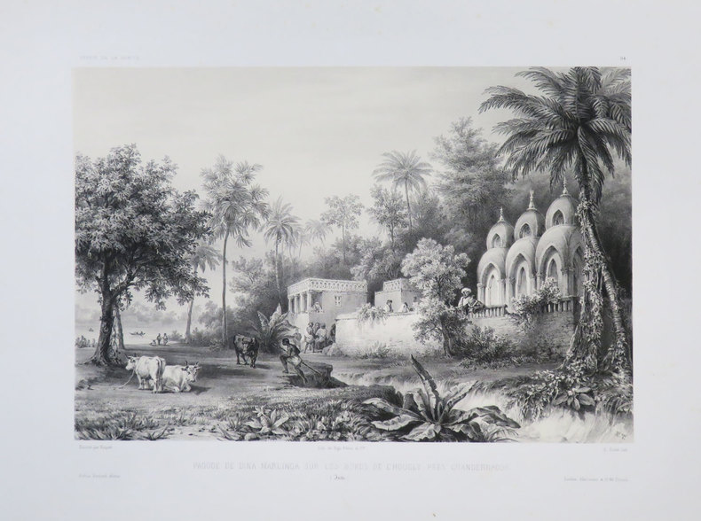
VAILLANT (Auguste-Nicolas).
[BENGALE] Pagode de Dina Marlinga sur les bords de l'Hougly près Chandernagor. (Inde).
[1840]. 223 x 291 mm.
书商的参考编号 : LBW-3682
|
|
|
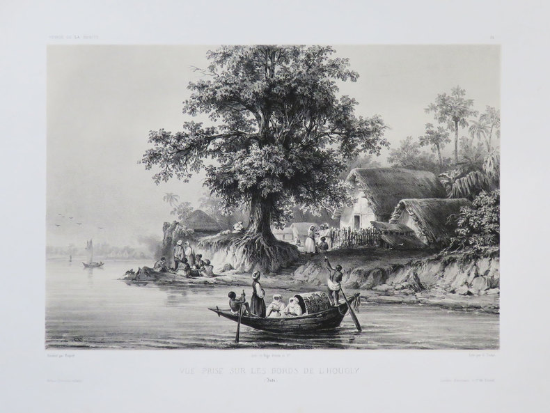
VAILLANT (Auguste-Nicolas).
[BENGALE] Vue prise sur les bords de l'Hougly. (Inde).
[1840]. 212 x 279 mm.
书商的参考编号 : LBW-3681
|
|
|
VAILLANT (Auguste-Nicolas).
[BOLIVIE] Rade de Cobija. Bolivie.
[1840]. 233 x 306 mm.
书商的参考编号 : LBW-3674

|
|
|
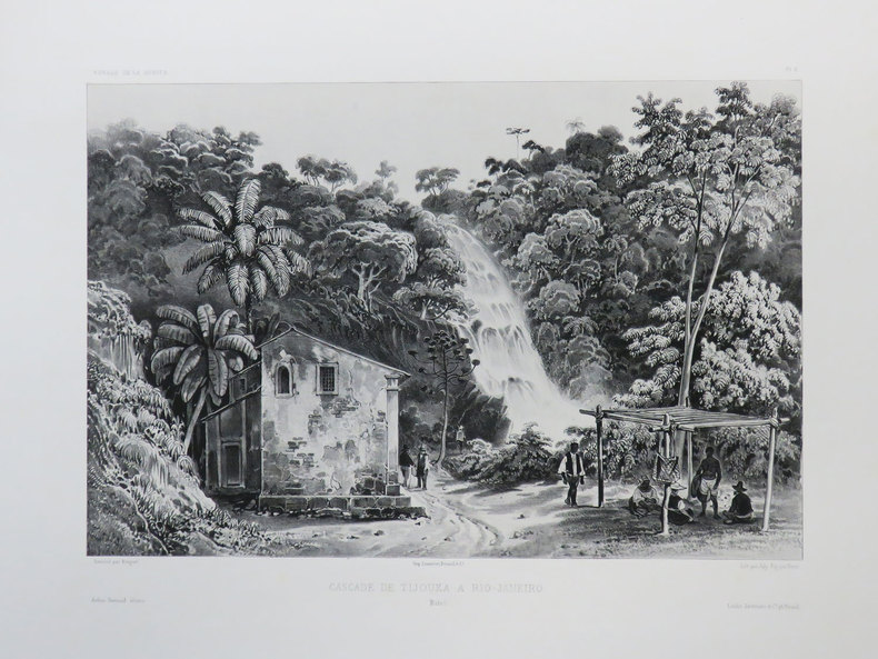
VAILLANT (Auguste-Nicolas).
[BRESIL] Cascade de Tijouka à Rio-Janeiro. Brésil.
[1840]. 227 x 298 mm.
书商的参考编号 : LBW-3437
|
|
|
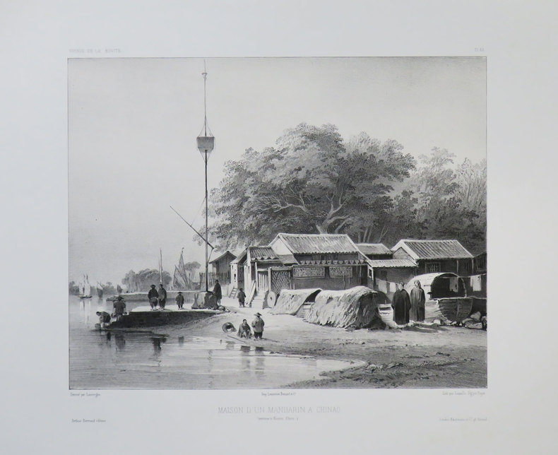
VAILLANT (Auguste-Nicolas).
[CANTON] Maison d'un mandarin à Chinao. (Environs de Canton, Chine).
[1840]. 235 x 263 mm.
书商的参考编号 : LBW-3679
|
|
|
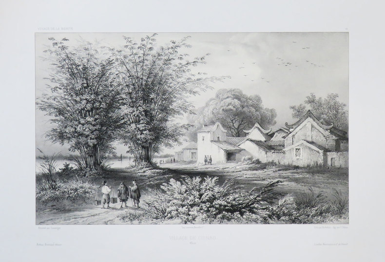
VAILLANT (Auguste-Nicolas).
[CANTON] Village de Chinao. Chine.
[1840]. 219 x 314 mm.
书商的参考编号 : LBW-3680
|
|
|
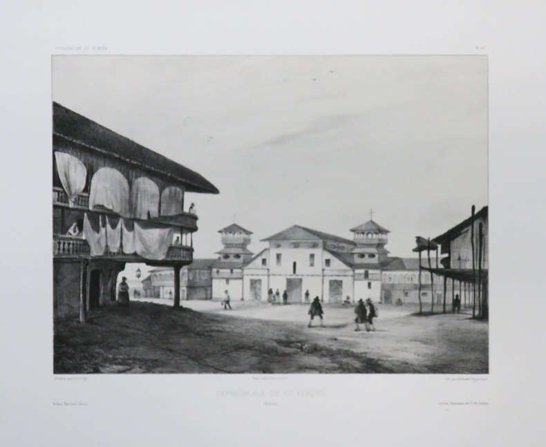
VAILLANT (Auguste-Nicolas).
[EQUATEUR] Cathédrale de Guayaquil. Colombie.
[1840]. 238 x 289 mm.
书商的参考编号 : LBW-3677
|
|
|
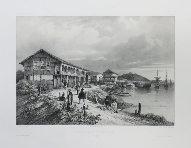
VAILLANT (Auguste-Nicolas).
[EQUATEUR] Vue du port de Guayaquil. Colombie.
[1840]. 222 x 294 mm.
书商的参考编号 : LBW-3676
|
|
|
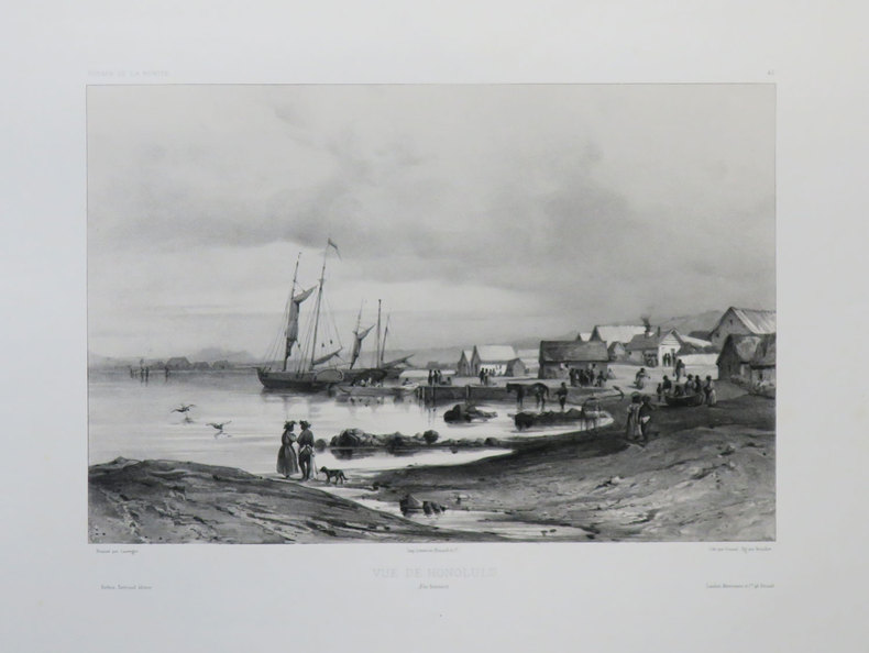
VAILLANT (Auguste-Nicolas).
[HAWAII] Vue de Honolulu. Îles Sandwich.
[1840]. 220 x 291 mm.
书商的参考编号 : LBW-3642
|
|
|
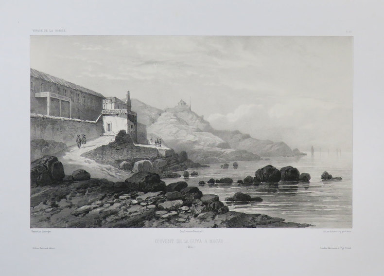
VAILLANT (Auguste-Nicolas).
[MACAO] Couvent de la Guya a Macao. (Chine).
[1840]. 219 x 322 mm.
书商的参考编号 : LBW-3678
|
|
|
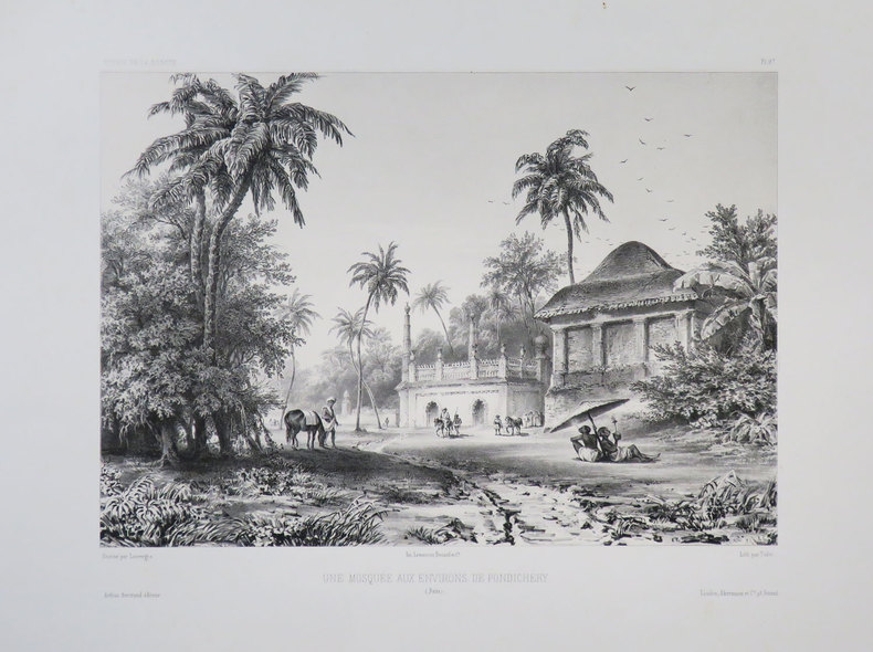
VAILLANT (Auguste-Nicolas).
[PONDICHERY] Une mosquée aux environs de Pondichéry. (Inde).
[1840]. 230 x 287 mm.
书商的参考编号 : LBW-3683
|
|
|
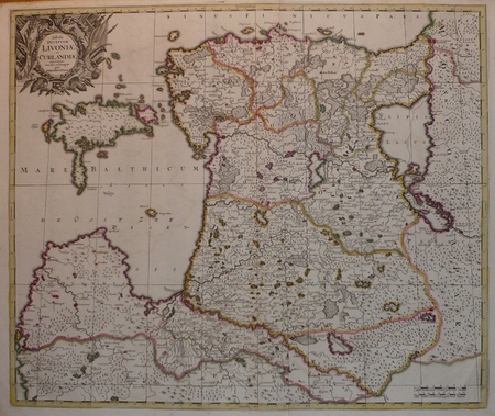
Valck, Gerard
Tabula Ducatuum Livoniae et Curlandiae recentior: incisa editaque per Gerardum Valck. Kupferstichkarte von Gerard Valk [Valck] (1650/51-1720) in altem Kolorit.
Amsterdam, [ca. 1680]. Plattenmaß: 59,5 x 48 cm [Blattmaß: 62,5 x 52,5 cm]. Mit kolorierter barocker Titelkartusche (oben links) u. zweifachem Maßstab.
书商的参考编号 : 52698

|
|
|
VALENCIENNES. . .
Carte au 1/200 000e. Sans date.
Une feuille 32x50 cm.
|
|
|
VALENCIENNES. MANUSCRIT.
[Valenciennes].
circa 1760 498 x 1070 mm.
书商的参考编号 : LBW00283

|
|
|
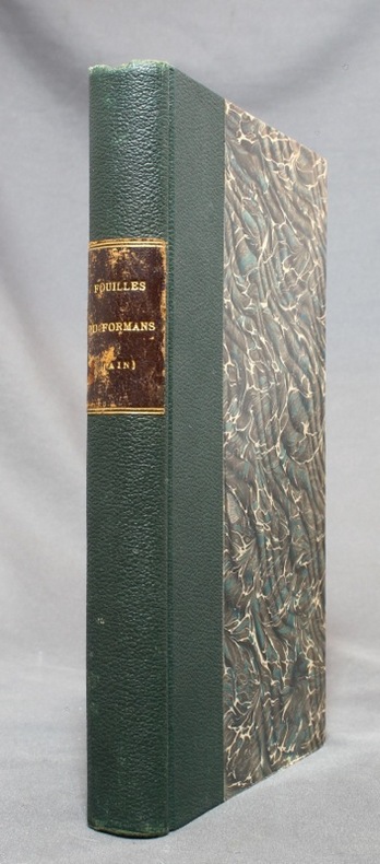
VALENTIN-SMITH J.-E.:
Fouilles dans la vallée du Formans (Ain) en 1862. Documents pour servir à l'histoire de la campagne de Jules César contre les Helvètes [relié avec] Les fouilles dans la vallée du Formans d'après un compte-rendu allemand.
Lyon, Librairie ancienne d'Auguste Brun / Imprimerie Mougin-Rusand, 1888. Grand in-8 de VII-153-[3]; [2]-4-[2] pages, demi-percaline verte, pièce de titre marron au dos, toutes les couvertures conservées.
书商的参考编号 : 14664
|
|
|
Valentine D H Edited By Illustrated By Phots Maps Drawings
The Natural History Of Upper Teesdale
Tyne Printing Works Ltd. Used - Good. Ships from the UK. Former Library book. Shows some signs of wear and may have some markings on the inside. 100% Money Back Guarantee. Your purchase also supports literacy charities. Tyne Printing Works Ltd unknown
书商的参考编号 : GRP112008822
|
|
|
Valette Maxime Passaglia Guillaume Guedj Didier Missbean
Vie de Merde : les inédits du monde entier tome 1
LGF 2012 96 pages 14x1 8x18 4cm. 2012. pocket_book. 96 pages.
书商的参考编号 : 500196306

|
|
|
VALK (Gerard).
[LETTONIE/ESTONIE] Tabula ducatuum Livoniae et Curlandiae.
Amsterdam, [circa 1700]. 487 x 578 mm.
书商的参考编号 : LBW04172
|
|
|
VALLAUD Pierre
La Seconde Guerre Mondiale. Collection : Témoins de l'histoire.
Paris, France Loisirs, 2002. 18 x 25, 703 pp., très nombreuses illustrations en N/B et en couleurs, cartonnage d'édition + jaquette, état neuf.
书商的参考编号 : 30590
|
|
|
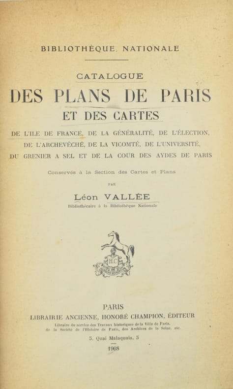
VALLEE (Léon)
Bibliothèque Nationale. Notice des documents exposés à la section des cartes. 2° édition revue et augmentée.
Paris, Champion, 1912. In-8, 65 pp., broché.
书商的参考编号 : B491
|
|
|
VALLET
Carte couleurs au 1/50 000?.
Une feuille 70x60 cm.
|
|
|
VALLOT (Henri) & VALLOT (Joseph).
[HAUTE-SAVOIE/CHAMONIX-MONT-BLANC] Environs de Chamonix extraits de la carte du massif du Mont Blanc (Édition touristique).
Paris, Girard et Barrère, 1934. 481 x 428 mm.
书商的参考编号 : LBW-8226

|
|
|
VALLOT Ch.:
Autour du Mont-Blanc. Choix d'excursions.
Paris, Girard, Barrère et Thomas, 1947. In-12 broché de 115-[15] pages, dos de toile bleue avec étiquette de titre (incomplète).
书商的参考编号 : 14347

|
|
|
Vallée (Léon).
Catalogue des plans de Paris et des cartes de l'Île-de-France de la généralité, de l'élection, de l'archevêché, de la vicomté, de l'Université, du grenier à sel et de la Cour des aydes de Paris, conservés à la Section des cartes et plans.
Paris, Honoré Champion, 1908. In-8 de II-576 pp., index, demi-maroquin prune, dos à nerfs, tête dorée, couverture et dos conservés (Honnelaître).
书商的参考编号 : 42603
|
|
|
VALVERDE Y ÁLVAREZ, Emilio (1848-1894).
Atlas de la Península Ibérica, islas adyacentes y posesiones de ultramar. Provincia de Madrid.
Madrid, Litografía A. Foruny, s.a. (1880). Un mapa de 56 x 39 cm., Escala 1:750000, plegado y contenido en carpeta de cartón.

|
|
|
VAN CHI-BONNARDELLE R?gine
Grand atlas du continent africain, sous la direction de R. Van-Chi-Bonnardelle.
Reliure toile de l'?diteur. 335 pages. 30x40 cm.
|
|
|
VAN DEN HAUTE, Robert.
Woluwe en cartes postales anciennes.- Woluwe in oude prentkaarten.
Petit in-8 oblong, 76 cartes en n&b., reliure cartonnage editeur illustrée.- RARE Tres bon état. [BU-11]
|
|
|
Van Den Keere Pieter
Barkshire and Buckinghamshire
Nice coloured two-sided reproductions of maps of " Barkshire and Buckinghamshire" Images the same size 12.2cms by 8.5cms as those in " England Wales Scotland and Ireland Described and Abridged. from a Farr Larger Voulume Done by John Speed." published by George Humble in 1627. Known as 'Miniature Speeds' Page size 18x12cm. See also listings describing other sheets in this series. Facsimile Reprint. Map. Near Fine. paperback
书商的参考编号 : 35160
|
|
|
Van Den Keere Pieter
Cornwaile Westmoreland & Comberland
Nice coloured two-sided reproductions of maps of "Westmoreland and Comberland"and"Cornwaile" Images the same size 12.2cms by 8.5cms as those in " England Wales Scotland and Ireland Described and Abridged. from a Farr Larger Voulume Done by John Speed." published by George Humble in 1627. Known as 'Miniature Speeds' Page size 18x12cm. See also listings describing other sheets in this series. Facsimile Reprint. Map. Near Fine. paperback
书商的参考编号 : 35158
|
|
|
Van Den Keere Pieter
Hartfordeshire and Huntingdonshire
Nice coloured two-sided reproductions of maps of "Hartfordeshire and Huntingdonshire" Images the same size 12.2cms by 8.5cms as those in " England Wales Scotland and Ireland Described and Abridged. from a Farr Larger Voulume Done by John Speed." published by George Humble in 1627. Known as 'Miniature Speeds' Page size 18x12cm. See also listings describing other sheets in this series. Facsimile Reprint. Map. Near Fine. paperback
书商的参考编号 : 35162
|
|
|
Van Den Keere Pieter
Kent and Lancaster
Nice coloured two-sided reproductions of maps of "Kent and Lancaster" Images the same size 12.2cms by 8.5cms as those in " England Wales Scotland and Ireland Described and Abridged. from a Farr Larger Voulume Done by John Speed." published by George Humble in 1627. Known as 'Miniature Speeds' Page size 18x12cm. See also listings describing other sheets in this series . Facsimile Reprint. Map. Near Fine. paperback
书商的参考编号 : 35161
|
|
|
Van Den Keere Pieter
Wilt Shire and Worcestershir
Nice coloured two-sided reproductions of maps of " Wilt Shire and Worcestershir" Images the same size 12.2cms by 8.5cms as those in " England Wales Scotland and Ireland Described and Abridged. from a Farr Larger Voulume Done by John Speed." published by George Humble in 1627. Known as 'Miniature Speeds' Page size 18x12cm. See also listings describing other sheets in this series. Facsimile Reprint. Map. Near Fine. paperback
书商的参考编号 : 35159
|
|
|
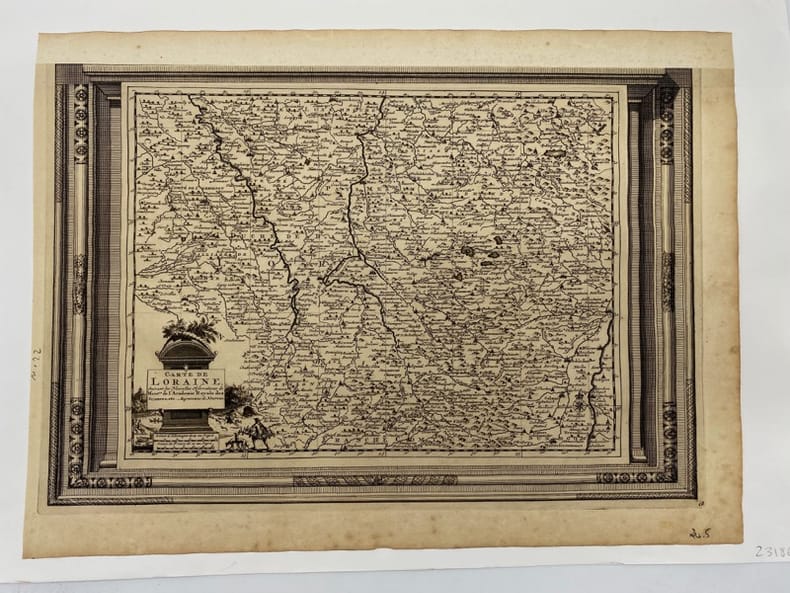
VAN DER AA.
Carte de Lorraine.. suivant les Nouvelles Observations de Messieurs de l'Académie Royale des Sciences, etc. Augmentées de Nouveau.
(c.1729), 26.5 x 39.5 cm - feuille : 31 x 42 cm , contrecollée sous passe-partout volant Marge supérieure découpée et restaurée.
书商的参考编号 : 231860
|
|
|
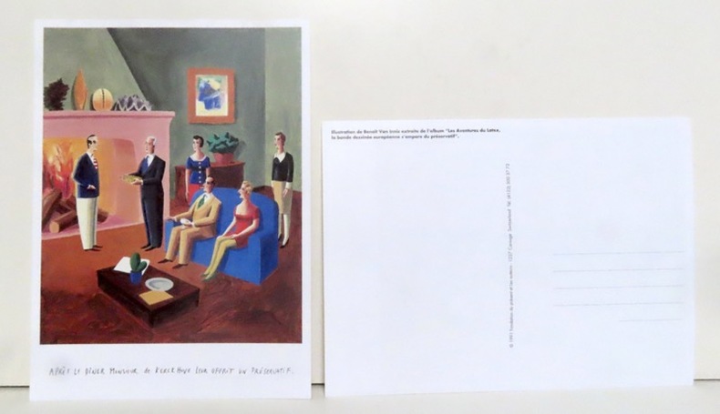
Van Innis Benoît:
Après le dîner Monsieur de Kerckhuve leur offrit un préservatif.
Carouge, Fondation du présent et les auteurs, 1991. Grande carte postale (16x22), représentant une illustration extraite de l'album "Les aventures du latex, la bande dessinée européenne s'empare du préservatif".
书商的参考编号 : 14343
|
|
|
VAN TENAC Charles
Traité du jeu de piquet. Lois, règles, conventions et maximes pour le bien jouer
Paris Passard s.d. [1877] in-12 br. couv. impr. jaune
书商的参考编号 : 11946
|
|
|
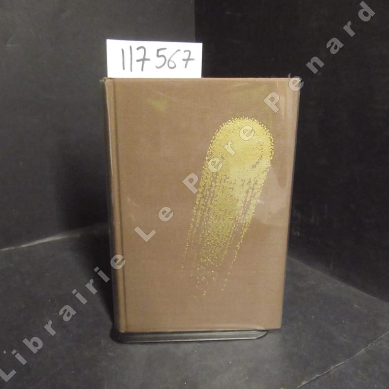
VANCE, Jack - Illustrations de Caza - Traduit par Michel Deutsch - Introduction par Jacques Chambon et Jean-Pierre Fontana
Tschaï 2
1971 Editions Opta, collection "Club du Livre d'Anticipation" (CLA) N° 34 - 1971 - In-8, reliures toilée marron avec titre doré au dos et décor (comète) doré sur le premier plat, sous rhodoïd - VII + 337 pages - Avec sa carte dépliante - Illustré de dessins originaux de Caza - Exemplaire numéroté N° 5486 / 6000
书商的参考编号 : 117567
|
|
|
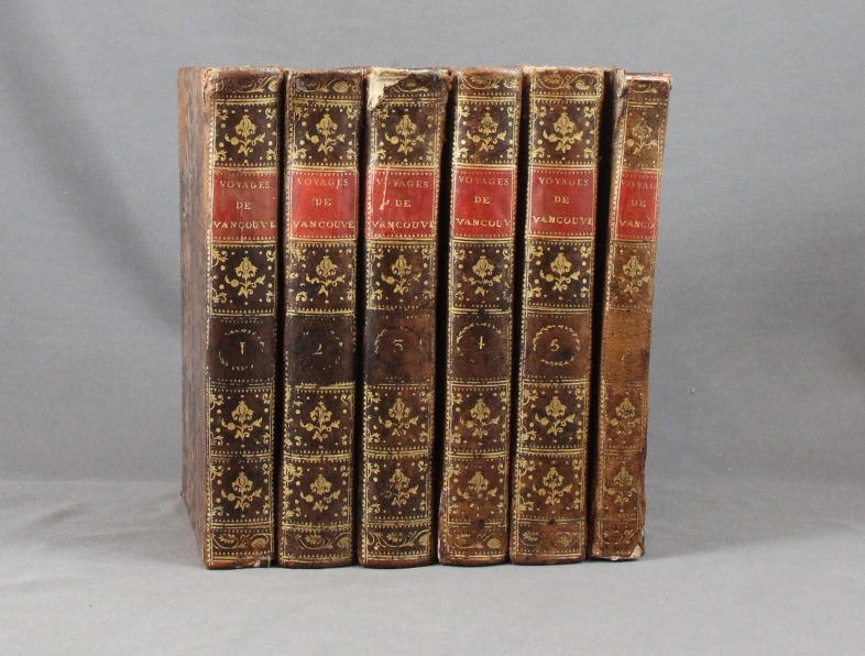
VANCOUVER George:
Voyage de découvertes, à l'océan Pacifique du nord, et autour du monde, entrepris par ordre de sa Majesté Britannique, exécuté, pendant les années 1790, 1791, 1792, 93, 1794 et 1795, par le capitaine George Vancouver. Traduits de l'anglais par P. F. Henry.
Paris, Didot jeune, an X. 6 volumes in-8 de [4]-VIII-341p., [4]-384p., [4]-381p., [4]-368p., [4]-438p., et un atlas de [4]p., 17 vues et 9 cartes, plein veau moucheté, dos lisses ornés de filets et fleurons dorés, pièces de titre rouge. Reliures un peu malmenées, coiffes frottées, mors un peu fendus, épidermures, auréoles pales à trois volumes, plus présentes dans l'atlas. Chaque première page est frappée d'un large tampon non identifié par votre serviteur.
书商的参考编号 : 6293
|
|
|
Vandiver Frank E./Long Barbara maps
Their Tattered Flags: the Epic of the Confederacy Military History series #5
College Station: Texas A&M University Press 1989. 3rd paperback printing. VG. xii 362 p. maps notes biblio index 8vo paperback; Texas A&M University Press paperback
书商的参考编号 : 18304 ???????? : 089096355X 9780890963555

|
|
|
VAR
Carte d?partementale couleurs au 1/200 000?me. Sans date.
Une feuille. 78x60 cm.
|
|
|
VAR
Carte d?partementale couleurs au 1/200 000e. Sans date.
Une feuille 60x80 cm.
|
|
|
VAR. MANUSCRIT.
Costes de Provence. Fréjus, Antibes, Nice, Monaco.
[circa 1750]. 366 x 444 mm.
书商的参考编号 : LBW-4141
|
|
|
Varganov, Alexei
Suzdal / Souzdal / Susdal
No marks or inscriptions. A very clean very tight copy with bright unmarked boards, bump to spine foot and no bumping to corners. Dust jacket not price clipped or marked with small nicks/tears to edges and crease to front dust flap. 175pp. The history, buildings, archtecture and people of the ancient Russian town of Suzdal. Mostly captioned colour and black & white photographs. Text in Russian, English, French and German. Very scarce in the UK.

|
|
 ?????????
 ?????PDF???
 RSS feed


