|
|
|
VUILLEMIN Alexandre ( 1812 - 1880 ) , Géographe
Carte du Département de la MARNE
Carte lithographiée en couleurs , dressée par Vuillemin d'après les cartes de Casini en 1853 , du dépôt de la guerre des Ponts et Chaussées et de la Marine . Extraite de l'Atlas : La France et ses Colonies . Edition de 1882 identique à celle de 1879 . Illustrée des villes , bourgs et cantons , communes ( parfois disparues ) , limites du département , limites des arrondissements , routes de 1ère et 2 ème classes , traverses , chemins de fer et stations , canaux , chemins de fer en construction ,entourée de personnages célèbres , de paysages , d'une vue de la ville principale , du blason , dont les textes sont écrits par Isidore . Format 22 cm x 18 cm ou sur marges de 34 cm x 24 cm , montée sur bristol crème de 42 cm x 30 cm . Envoyée en rouleau . - Cartes et Plans . - Une feuille , 250 gr.

|
|
|
VUILLEMIN Alexandre ( 1812 - 1880 ) , Géographe
Carte du Département de la MAYENNE
Paris MIGEON 1882 In Plano Carte lithographiée en couleurs , dressée par Vuillemin d'après les cartes de Casini en 1853 , du dépôt de la guerre des Ponts et Chaussées et de la Marine . Extraite de l'Atlas : La France et ses Colonies . Edition de 1882 identique à celle de 1879 . Illustrée des villes , bourgs et cantons , communes ( parfois disparues ) , limites du département , limites des arrondissements , routes de 1ère et 2 ème classes , traverses , chemins de fer et stations , canaux , chemins de fer en construction ,entourée de personnages célèbres , de paysages , d'une vue de la ville principale , du blason , dont les textes sont écrits par Del Fillatreau . Format 22 cm x 18 cm ou sur marges de 34 cm x 24 cm , montée sur bristol crème de 42 cm x 30 cm . Envoyée en rouleau . - Cartes et Plans . - Une feuille , 250 gr.
Référence libraire : 022775
|
|
|
VUILLEMIN Alexandre ( 1812 - 1880 ) , Géographe
Carte du Département de la MAYENNE
Carte lithographiée en couleurs , dressée par Vuillemin d'après les cartes de Casini en 1853 , du dépôt de la guerre des Ponts et Chaussées et de la Marine . Extraite de l'Atlas : La France et ses Colonies . Edition de 1882 identique à celle de 1879 . Illustrée des villes , bourgs et cantons , communes ( parfois disparues ) , limites du département , limites des arrondissements , routes de 1ère et 2 ème classes , traverses , chemins de fer et stations , canaux , chemins de fer en construction ,entourée de personnages célèbres , de paysages , d'une vue de la ville principale , du blason , dont les textes sont écrits par Del Fillatreau . Format 22 cm x 18 cm ou sur marges de 34 cm x 24 cm , montée sur bristol crème de 42 cm x 30 cm . Envoyée en rouleau . - Cartes et Plans . - Une feuille , 250 gr.

|
|
|
VUILLEMIN Alexandre ( 1812 - 1880 ) , Géographe
Carte du Département de la MEURTHE
Paris MIGEON 1882 In Plano Carte lithographiée en couleurs , dressée par Vuillemin d'après les cartes de Casini en 1853 , du dépôt de la guerre des Ponts et Chaussées et de la Marine . Extraite de l'Atlas : La France et ses Colonies . Edition de 1882 identique à celle de 1879 . Illustrée des villes , bourgs et cantons , communes ( parfois disparues ) , limites du département , limites des arrondissements , routes de 1ère et 2 ème classes , traverses , chemins de fer et stations , canaux , chemins de fer en construction ,entourée de personnages célèbres , de paysages , d'une vue de la ville principale , du blason , dont les textes sont écrits par Isidore . Format 22 cm x 18 cm ou sur marges de 34 cm x 24 cm , montée sur bristol crème de 42 cm x 30 cm . Envoyée en rouleau . - Cartes et Plans . - Une feuille , 250 gr.
Référence libraire : 022776
|
|
|
VUILLEMIN Alexandre ( 1812 - 1880 ) , Géographe
Carte du Département de la MEURTHE
Carte lithographiée en couleurs , dressée par Vuillemin d'après les cartes de Casini en 1853 , du dépôt de la guerre des Ponts et Chaussées et de la Marine . Extraite de l'Atlas : La France et ses Colonies . Edition de 1882 identique à celle de 1879 . Illustrée des villes , bourgs et cantons , communes ( parfois disparues ) , limites du département , limites des arrondissements , routes de 1ère et 2 ème classes , traverses , chemins de fer et stations , canaux , chemins de fer en construction ,entourée de personnages célèbres , de paysages , d'une vue de la ville principale , du blason , dont les textes sont écrits par Isidore . Format 22 cm x 18 cm ou sur marges de 34 cm x 24 cm , montée sur bristol crème de 42 cm x 30 cm . Envoyée en rouleau . - Cartes et Plans . - Une feuille , 250 gr.

|
|
|
VUILLEMIN Alexandre ( 1812 - 1880 ) , Géographe
Carte du Département de la MEURTHE ET MOSELLE
Paris MIGEON 1882 In Plano Carte lithographiée en couleurs , dressée par Vuillemin d'après les cartes de Casini en 1853 , du dépôt de la guerre des Ponts et Chaussées et de la Marine . Extraite de l'Atlas : La France et ses Colonies . Edition de 1882 identique à celle de 1879 . Illustrée des villes , bourgs et cantons , communes ( parfois disparues ) , limites du département , limites des arrondissements , routes de 1ère et 2 ème classes , traverses , chemins de fer et stations , canaux , chemins de fer en construction ,entourée de personnages célèbres , de paysages , d'une vue de la ville principale , du blason , dont les textes sont écrits par Isidore . Format 22 cm x 18 cm ou sur marges de 34 cm x 24 cm , montée sur bristol crème de 42 cm x 30 cm . Envoyée en rouleau . - Cartes et Plans . - Une feuille , 250 gr.
Référence libraire : 022777

|
|
|
VUILLEMIN Alexandre ( 1812 - 1880 ) , Géographe
Carte du Département de la MEURTHE ET MOSELLE
Carte lithographiée en couleurs , dressée par Vuillemin d'après les cartes de Casini en 1853 , du dépôt de la guerre des Ponts et Chaussées et de la Marine . Extraite de l'Atlas : La France et ses Colonies . Edition de 1882 identique à celle de 1879 . Illustrée des villes , bourgs et cantons , communes ( parfois disparues ) , limites du département , limites des arrondissements , routes de 1ère et 2 ème classes , traverses , chemins de fer et stations , canaux , chemins de fer en construction ,entourée de personnages célèbres , de paysages , d'une vue de la ville principale , du blason , dont les textes sont écrits par Isidore . Format 22 cm x 18 cm ou sur marges de 34 cm x 24 cm , montée sur bristol crème de 42 cm x 30 cm . Envoyée en rouleau . - Cartes et Plans . - Une feuille , 250 gr.

|
|
|
VUILLEMIN Alexandre ( 1812 - 1880 ) , Géographe
Carte du Département de la MEUSE
Paris MIGEON 1882 In Plano Carte lithographiée en couleurs , dressée par Vuillemin d'après les cartes de Casini en 1853 , du dépôt de la guerre des Ponts et Chaussées et de la Marine . Extraite de l'Atlas : La France et ses Colonies . Edition de 1882 identique à celle de 1879 . Illustrée des villes , bourgs et cantons , communes ( parfois disparues ) , limites du département , limites des arrondissements , routes de 1ère et 2 ème classes , traverses , chemins de fer et stations , canaux , chemins de fer en construction ,entourée de personnages célèbres , de paysages , d'une vue de la ville principale , du blason , dont les textes sont écrits par Isidore . Format 22 cm x 18 cm ou sur marges de 34 cm x 24 cm , montée sur bristol crème de 42 cm x 30 cm . Envoyée en rouleau . - Cartes et Plans . - Une feuille , 250 gr.
Référence libraire : 022778
|
|
|
VUILLEMIN Alexandre ( 1812 - 1880 ) , Géographe
Carte du Département de la MEUSE
Carte lithographiée en couleurs , dressée par Vuillemin d'après les cartes de Casini en 1853 , du dépôt de la guerre des Ponts et Chaussées et de la Marine . Extraite de l'Atlas : La France et ses Colonies . Edition de 1882 identique à celle de 1879 . Illustrée des villes , bourgs et cantons , communes ( parfois disparues ) , limites du département , limites des arrondissements , routes de 1ère et 2 ème classes , traverses , chemins de fer et stations , canaux , chemins de fer en construction ,entourée de personnages célèbres , de paysages , d'une vue de la ville principale , du blason , dont les textes sont écrits par Isidore . Format 22 cm x 18 cm ou sur marges de 34 cm x 24 cm , montée sur bristol crème de 42 cm x 30 cm . Envoyée en rouleau . - Cartes et Plans . - Une feuille , 250 gr.

|
|
|
VUILLEMIN Alexandre ( 1812 - 1880 ) , Géographe
Carte du département de la MOSELLE
Paris MIGEON 1882 In Plano Carte lithographiée en couleurs , dressée par Vuillemin d'après les cartes de Casini en 1853 , du dépôt de la guerre des Ponts et Chaussées et de la Marine . Extraite de l'Atlas : La France et ses Colonies . Edition de 1882 identique à celle de 1879 . Illustrée des villes , bourgs et cantons , communes ( parfois disparues ) , limites du département , limites des arrondissements , routes de 1ère et 2 ème classes , traverses , chemins de fer et stations , canaux , chemins de fer en construction ,entourée de personnages célèbres , de paysages , d'une vue de la ville principale , du blason , dont les textes sont écrits par Isidore . Format 22 cm x 18 cm ou sur marges de 34 cm x 24 cm , montée sur bristol crème de 42 cm x 30 cm . Envoyée en rouleau . - Cartes et Plans . - Une feuille , 250 gr.
Référence libraire : 022780
|
|
|
VUILLEMIN Alexandre ( 1812 - 1880 ) , Géographe
Carte du département de la MOSELLE
Carte lithographiée en couleurs , dressée par Vuillemin d'après les cartes de Casini en 1853 , du dépôt de la guerre des Ponts et Chaussées et de la Marine . Extraite de l'Atlas : La France et ses Colonies . Edition de 1882 identique à celle de 1879 . Illustrée des villes , bourgs et cantons , communes ( parfois disparues ) , limites du département , limites des arrondissements , routes de 1ère et 2 ème classes , traverses , chemins de fer et stations , canaux , chemins de fer en construction ,entourée de personnages célèbres , de paysages , d'une vue de la ville principale , du blason , dont les textes sont écrits par Isidore . Format 22 cm x 18 cm ou sur marges de 34 cm x 24 cm , montée sur bristol crème de 42 cm x 30 cm . Envoyée en rouleau . - Cartes et Plans . - Une feuille , 250 gr.

|
|
|
VUILLEMIN Alexandre ( 1812 - 1880 ) , Géographe
Carte du département de la NIEVRE
Paris MIGEON 1882 In Plano Carte lithographiée en couleurs , dressée par Vuillemin d'après les cartes de Casini en 1853 , du dépôt de la guerre des Ponts et Chaussées et de la Marine . Extraite de l'Atlas : La France et ses Colonies . Edition de 1882 identique à celle de 1879 . Illustrée des villes , bourgs et cantons , communes ( parfois disparues ) , limites du département , limites des arrondissements , routes de 1ère et 2 ème classes , traverses , chemins de fer et stations , canaux , chemins de fer en construction ,entourée de personnages célèbres , de paysages , d'une vue de la ville principale , du blason , dont les textes sont écrits par Isidore . Format 22 cm x 18 cm ou sur marges de 34 cm x 24 cm , montée sur bristol crème de 42 cm x 30 cm . Envoyée en rouleau . - Cartes et Plans . - Une feuille , 250 gr.
Référence libraire : 022781
|
|
|
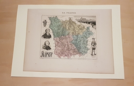
VUILLEMIN Alexandre ( 1812 - 1880 ) , Géographe
Carte du département de la NIEVRE
Carte lithographiée en couleurs , dressée par Vuillemin d'après les cartes de Casini en 1853 , du dépôt de la guerre des Ponts et Chaussées et de la Marine . Extraite de l'Atlas : La France et ses Colonies . Edition de 1882 identique à celle de 1879 . Illustrée des villes , bourgs et cantons , communes ( parfois disparues ) , limites du département , limites des arrondissements , routes de 1ère et 2 ème classes , traverses , chemins de fer et stations , canaux , chemins de fer en construction ,entourée de personnages célèbres , de paysages , d'une vue de la ville principale , du blason , dont les textes sont écrits par Isidore . Format 22 cm x 18 cm ou sur marges de 34 cm x 24 cm , montée sur bristol crème de 42 cm x 30 cm . Envoyée en rouleau . - Cartes et Plans . - Une feuille , 250 gr.

|
|
|
VUILLEMIN Alexandre ( 1812 - 1880 ) , Géographe
Carte du département de la SARTHE
Paris MIGEON 1882 In Plano Carte lithographiée en couleurs , dressée par Vuillemin d'après les cartes de Casini en 1853 , du dépôt de la guerre des Ponts et Chaussées et de la Marine . Extraite de l'Atlas : La France et ses Colonies . Edition de 1882 identique à celle de 1879 . Illustrée des villes , bourgs et cantons , communes ( parfois disparues ) , limites du département , limites des arrondissements , routes de 1ère et 2 ème classes , traverses , chemins de fer et stations , canaux , chemins de fer en construction ,entourée de personnages célèbres , de paysages , d'une vue de la ville principale , du blason , dont les textes sont écrits par Isidore . Format 22 cm x 18 cm ou sur marges de 34 cm x 24 cm , montée sur bristol crème de 42 cm x 30 cm . Envoyée en rouleau . - Cartes et Plans . - Une feuille , 250 gr.
Référence libraire : 022804
|
|
|
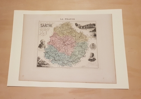
VUILLEMIN Alexandre ( 1812 - 1880 ) , Géographe
Carte du département de la SARTHE
Carte lithographiée en couleurs , dressée par Vuillemin d'après les cartes de Casini en 1853 , du dépôt de la guerre des Ponts et Chaussées et de la Marine . Extraite de l'Atlas : La France et ses Colonies . Edition de 1882 identique à celle de 1879 . Illustrée des villes , bourgs et cantons , communes ( parfois disparues ) , limites du département , limites des arrondissements , routes de 1ère et 2 ème classes , traverses , chemins de fer et stations , canaux , chemins de fer en construction ,entourée de personnages célèbres , de paysages , d'une vue de la ville principale , du blason , dont les textes sont écrits par Isidore . Format 22 cm x 18 cm ou sur marges de 34 cm x 24 cm , montée sur bristol crème de 42 cm x 30 cm . Envoyée en rouleau . - Cartes et Plans . - Une feuille , 250 gr.

|
|
|
VUILLEMIN Alexandre ( 1812 - 1880 ) , Géographe
Carte du département de la SAVOIE
Paris MIGEON 1882 In Plano Carte lithographiée en couleurs , dressée par Vuillemin d'après les cartes de Casini en 1853 , du dépôt de la guerre des Ponts et Chaussées et de la Marine . Extraite de l'Atlas : La France et ses Colonies . Edition de 1882 identique à celle de 1879 . Illustrée des villes , bourgs et cantons , communes ( parfois disparues ) , limites du département , limites des arrondissements , routes de 1ère et 2 ème classes , traverses , chemins de fer et stations , canaux , chemins de fer en construction ,entourée de personnages célèbres , de paysages , d'une vue de la ville principale , du blason , dont les textes sont écrits par J. Bénard . Format 22 cm x 18 cm ou sur marges de 34 cm x 24 cm , montée sur bristol crème de 42 cm x 30 cm . Envoyée en rouleau . - Cartes et Plans . - Une feuille , 250 gr.
Référence libraire : 022789

|
|
|
VUILLEMIN Alexandre ( 1812 - 1880 ) , Géographe
Carte du département de la SAVOIE
Carte lithographiée en couleurs , dressée par Vuillemin d'après les cartes de Casini en 1853 , du dépôt de la guerre des Ponts et Chaussées et de la Marine . Extraite de l'Atlas : La France et ses Colonies . Edition de 1882 identique à celle de 1879 . Illustrée des villes , bourgs et cantons , communes ( parfois disparues ) , limites du département , limites des arrondissements , routes de 1ère et 2 ème classes , traverses , chemins de fer et stations , canaux , chemins de fer en construction ,entourée de personnages célèbres , de paysages , d'une vue de la ville principale , du blason , dont les textes sont écrits par J. Bénard . Format 22 cm x 18 cm ou sur marges de 34 cm x 24 cm , montée sur bristol crème de 42 cm x 30 cm . Envoyée en rouleau . - Cartes et Plans . - Une feuille , 250 gr.

|
|
|
VUILLEMIN Alexandre ( 1812 - 1880 ) , Géographe
Carte du département de la SAÔNE- ET- LOIRE
Paris MIGEON 1882 In Plano Carte lithographiée en couleurs , dressée par Vuillemin d'après les cartes de Casini en 1853 , du dépôt de la guerre des Ponts et Chaussées et de la Marine . Extraite de l'Atlas : La France et ses Colonies . Edition de 1882 identique à celle de 1879 . Illustrée des villes , bourgs et cantons , communes ( parfois disparues ) , limites du département , limites des arrondissements , routes de 1ère et 2 ème classes , traverses , chemins de fer et stations , canaux , chemins de fer en construction ,entourée de personnages célèbres , de paysages , d'une vue de la ville principale , du blason , dont les textes sont écrits par Isidore . Format 22 cm x 18 cm ou sur marges de 34 cm x 24 cm , montée sur bristol crème de 42 cm x 30 cm . Envoyée en rouleau . - Cartes et Plans . - Une feuille , 250 gr.
Référence libraire : 022806

|
|
|
VUILLEMIN Alexandre ( 1812 - 1880 ) , Géographe
Carte du département de la SAÔNE- ET- LOIRE
Carte lithographiée en couleurs , dressée par Vuillemin d'après les cartes de Casini en 1853 , du dépôt de la guerre des Ponts et Chaussées et de la Marine . Extraite de l'Atlas : La France et ses Colonies . Edition de 1882 identique à celle de 1879 . Illustrée des villes , bourgs et cantons , communes ( parfois disparues ) , limites du département , limites des arrondissements , routes de 1ère et 2 ème classes , traverses , chemins de fer et stations , canaux , chemins de fer en construction ,entourée de personnages célèbres , de paysages , d'une vue de la ville principale , du blason , dont les textes sont écrits par Isidore . Format 22 cm x 18 cm ou sur marges de 34 cm x 24 cm , montée sur bristol crème de 42 cm x 30 cm . Envoyée en rouleau . - Cartes et Plans . - Une feuille , 250 gr.

|
|
|
VUILLEMIN Alexandre ( 1812 - 1880 ) , Géographe
Carte du département de la SEINE INFERIEURE ( SEINE MARITIME )
Paris MIGEON 1882 In Plano Carte lithographiée en couleurs , dressée par Vuillemin d'après les cartes de Casini en 1853 , du dépôt de la guerre des Ponts et Chaussées et de la Marine . Extraite de l'Atlas : La France et ses Colonies . Edition de 1882 identique à celle de 1879 . Illustrée des villes , bourgs et cantons , communes ( parfois disparues ) , limites du département , limites des arrondissements , routes de 1ère et 2 ème classes , traverses , chemins de fer et stations , canaux , chemins de fer en construction ,entourée de personnages célèbres , de paysages , d'une vue de la ville principale , du blason , dont les textes sont écrits par Duval . Format 22 cm x 18 cm ou sur marges de 34 cm x 24 cm , montée sur bristol crème de 42 cm x 30 cm . Envoyée en rouleau . - Cartes et Plans . - Une feuille , 250 gr.
Référence libraire : 022791
|
|
|
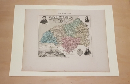
VUILLEMIN Alexandre ( 1812 - 1880 ) , Géographe
Carte du département de la SEINE INFERIEURE ( SEINE MARITIME )
Carte lithographiée en couleurs , dressée par Vuillemin d'après les cartes de Casini en 1853 , du dépôt de la guerre des Ponts et Chaussées et de la Marine . Extraite de l'Atlas : La France et ses Colonies . Edition de 1882 identique à celle de 1879 . Illustrée des villes , bourgs et cantons , communes ( parfois disparues ) , limites du département , limites des arrondissements , routes de 1ère et 2 ème classes , traverses , chemins de fer et stations , canaux , chemins de fer en construction ,entourée de personnages célèbres , de paysages , d'une vue de la ville principale , du blason , dont les textes sont écrits par Duval . Format 22 cm x 18 cm ou sur marges de 34 cm x 24 cm , montée sur bristol crème de 42 cm x 30 cm . Envoyée en rouleau . - Cartes et Plans . - Une feuille , 250 gr.

|
|
|
VUILLEMIN Alexandre ( 1812 - 1880 ) , Géographe
Carte du département de la SOMME
Paris MIGEON 1882 In Plano Carte lithographiée en couleurs , dressée par Vuillemin d'après les cartes de Casini en 1853 , du dépôt de la guerre des Ponts et Chaussées et de la Marine . Extraite de l'Atlas : La France et ses Colonies . Edition de 1882 identique à celle de 1879 . Illustrée des villes , bourgs et cantons , communes ( parfois disparues ) , limites du département , limites des arrondissements , routes de 1ère et 2 ème classes , traverses , chemins de fer et stations , canaux , chemins de fer en construction ,entourée de personnages célèbres , de paysages , d'une vue de la ville principale , du blason , dont les textes sont écrits par Isidore . Format 22 cm x 18 cm ou sur marges de 34 cm x 24 cm , montée sur bristol crème de 42 cm x 30 cm . Envoyée en rouleau . - Cartes et Plans . - Une feuille , 250 gr.
Référence libraire : 022794
|
|
|
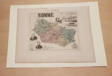
VUILLEMIN Alexandre ( 1812 - 1880 ) , Géographe
Carte du département de la SOMME
Carte lithographiée en couleurs , dressée par Vuillemin d'après les cartes de Casini en 1853 , du dépôt de la guerre des Ponts et Chaussées et de la Marine . Extraite de l'Atlas : La France et ses Colonies . Edition de 1882 identique à celle de 1879 . Illustrée des villes , bourgs et cantons , communes ( parfois disparues ) , limites du département , limites des arrondissements , routes de 1ère et 2 ème classes , traverses , chemins de fer et stations , canaux , chemins de fer en construction ,entourée de personnages célèbres , de paysages , d'une vue de la ville principale , du blason , dont les textes sont écrits par Isidore . Format 22 cm x 18 cm ou sur marges de 34 cm x 24 cm , montée sur bristol crème de 42 cm x 30 cm . Envoyée en rouleau . - Cartes et Plans . - Une feuille , 250 gr.

|
|
|
VUILLEMIN Alexandre ( 1812 - 1880 ) , Géographe
Carte du département de la VENDEE
Paris MIGEON 1882 In Plano Carte lithographiée en couleurs , dressée par Vuillemin d'après les cartes de Casini en 1853 , du dépôt de la guerre des Ponts et Chaussées et de la Marine . Extraite de l'Atlas : La France et ses Colonies . Edition de 1882 identique à celle de 1879 . Illustrée des villes , bourgs et cantons , communes ( parfois disparues ) , limites du département , limites des arrondissements , routes de 1ère et 2 ème classes , traverses , chemins de fer et stations , canaux , chemins de fer en construction ,entourée de personnages célèbres , de paysages , d'une vue de la ville principale , du blason , dont les textes sont écrits par Isidore . Format 22 cm x 18 cm ou sur marges de 34 cm x 24 cm , montée sur bristol crème de 42 cm x 30 cm . Envoyée en rouleau . - Cartes et Plans . - Une feuille , 250 gr.
Référence libraire : 022799
|
|
|
VUILLEMIN Alexandre ( 1812 - 1880 ) , Géographe
Carte du département de la VENDEE
Carte lithographiée en couleurs , dressée par Vuillemin d'après les cartes de Casini en 1853 , du dépôt de la guerre des Ponts et Chaussées et de la Marine . Extraite de l'Atlas : La France et ses Colonies . Edition de 1882 identique à celle de 1879 . Illustrée des villes , bourgs et cantons , communes ( parfois disparues ) , limites du département , limites des arrondissements , routes de 1ère et 2 ème classes , traverses , chemins de fer et stations , canaux , chemins de fer en construction ,entourée de personnages célèbres , de paysages , d'une vue de la ville principale , du blason , dont les textes sont écrits par Isidore . Format 22 cm x 18 cm ou sur marges de 34 cm x 24 cm , montée sur bristol crème de 42 cm x 30 cm . Envoyée en rouleau . - Cartes et Plans . - Une feuille , 250 gr.

|
|
|
VUILLEMIN Alexandre ( 1812 - 1880 ) , Géographe
Carte du département de la VIENNE
Paris MIGEON 1882 In Plano Carte lithographiée en couleurs , dressée par Vuillemin d'après les cartes de Casini en 1853 , du dépôt de la guerre des Ponts et Chaussées et de la Marine . Extraite de l'Atlas : La France et ses Colonies . Edition de 1882 identique à celle de 1879 . Illustrée des villes , bourgs et cantons , communes ( parfois disparues ) , limites du département , limites des arrondissements , routes de 1ère et 2 ème classes , traverses , chemins de fer et stations , canaux , chemins de fer en construction ,entourée de personnages célèbres , de paysages , d'une vue de la ville principale , du blason , dont les textes sont écrits par Housselin et Isidore . Format 22 cm x 18 cm ou sur marges de 34 cm x 24 cm , montée sur bristol crème de 42 cm x 30 cm . Envoyée en rouleau . - Cartes et Plans . - Une feuille , 250 gr.
Référence libraire : 022803
|
|
|
VUILLEMIN Alexandre ( 1812 - 1880 ) , Géographe
Carte du département de la VIENNE
Carte lithographiée en couleurs , dressée par Vuillemin d'après les cartes de Casini en 1853 , du dépôt de la guerre des Ponts et Chaussées et de la Marine . Extraite de l'Atlas : La France et ses Colonies . Edition de 1882 identique à celle de 1879 . Illustrée des villes , bourgs et cantons , communes ( parfois disparues ) , limites du département , limites des arrondissements , routes de 1ère et 2 ème classes , traverses , chemins de fer et stations , canaux , chemins de fer en construction ,entourée de personnages célèbres , de paysages , d'une vue de la ville principale , du blason , dont les textes sont écrits par Housselin et Isidore . Format 22 cm x 18 cm ou sur marges de 34 cm x 24 cm , montée sur bristol crème de 42 cm x 30 cm . Envoyée en rouleau . - Cartes et Plans . - Une feuille , 250 gr.

|
|
|
VUILLEMIN Alexandre ( 1812 - 1880 ) , Géographe
Carte du Département des HAUTES - ALPES
Paris MIGEON 1882 In Plano Carte lithographiée en couleurs , dressée par Vuillemin d'après les cartes de Casini en 1853 , du dépôt de la guerre des Ponts et Chaussées et de la Marine . Extraite de l'Atlas : La France et ses Colonies . Edition de 1882 identique à celle de 1879 . Illustrée des villes , bourgs et cantons , communes ( parfois disparues ) , limites du département , limites des arrondissements , routes de 1ère et 2 ème classes , traverses , chemins de fer et stations , canaux , chemins de fer en construction ,entourée de personnages célèbres , de paysages , d'une vue de la ville principale , du blason , dont les textes sont écrits par Isidore . Format 22 cm x 18 cm ou sur marges de 34 cm x 24 cm , montée sur bristol crème de 42 cm x 30 cm . Envoyée en rouleau . - Cartes et Plans . - Une feuille , 250 gr.
Référence libraire : 022753
|
|
|
VUILLEMIN Alexandre ( 1812 - 1880 ) , Géographe
Carte du Département des HAUTES - PYRENEES
Paris MIGEON 1882 In Plano Carte lithographiée en couleurs , dressée par Vuillemin d'après les cartes de Casini en 1853 , du dépôt de la guerre des Ponts et Chaussées et de la Marine . Extraite de l'Atlas : La France et ses Colonies . Edition de 1882 identique à celle de 1879 . Illustrée des villes , bourgs et cantons , communes ( parfois disparues ) , limites du département , limites des arrondissements , routes de 1ère et 2 ème classes , traverses , chemins de fer et stations , canaux , chemins de fer en construction ,entourée de personnages célèbres , de paysages , d'une vue de la ville principale , du blason , dont les textes sont écrits par Isidore . Format 22 cm x 18 cm ou sur marges de 34 cm x 24 cm , montée sur bristol crème de 42 cm x 30 cm . Envoyée en rouleau . - Cartes et Plans . - Une feuille , 250 gr.
Référence libraire : 022755
|
|
|
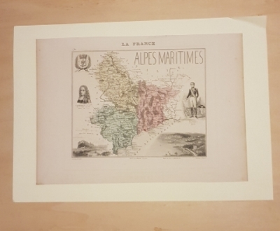
VUILLEMIN Alexandre ( 1812 - 1880 ) , Géographe
Carte du Département des ALPES MARITIMES
Paris MIGEON 1882 In Plano Carte lithographiée en couleurs , dressée par Vuillemin d'après les cartes de Casini en 1853 , du dépôt de la guerre des Ponts et Chaussées et de la Marine . Extraite de l'Atlas : La France et ses Colonies . Edition de 1882 identique à celle de 1879 . Illustrée des villes , bourgs et cantons , communes ( parfois disparues ) , limites du département , limites des arrondissements , routes de 1ère et 2 ème classes , traverses , chemins de fer et stations , canaux , chemins de fer en construction ,entourée de personnages célèbres , de paysages , d'une vue de la ville principale , du blason , dont les textes sont écrits par J. Bénard . Format 22 cm x 18 cm ou sur marges de 34 cm x 24 cm , montée sur bristol crème de 42 cm x 30 cm . Envoyée en rouleau . - Cartes et Plans . - Une feuille , 250 gr.
Référence libraire : 022721
|
|
|
VUILLEMIN Alexandre ( 1812 - 1880 ) , Géographe
Carte du Département des ALPES MARITIMES
Carte lithographiée en couleurs , dressée par Vuillemin d'après les cartes de Casini en 1853 , du dépôt de la guerre des Ponts et Chaussées et de la Marine . Extraite de l'Atlas : La France et ses Colonies . Edition de 1882 identique à celle de 1879 . Illustrée des villes , bourgs et cantons , communes ( parfois disparues ) , limites du département , limites des arrondissements , routes de 1ère et 2 ème classes , traverses , chemins de fer et stations , canaux , chemins de fer en construction ,entourée de personnages célèbres , de paysages , d'une vue de la ville principale , du blason , dont les textes sont écrits par J. Bénard . Format 22 cm x 18 cm ou sur marges de 34 cm x 24 cm , montée sur bristol crème de 42 cm x 30 cm . Envoyée en rouleau . - Cartes et Plans . - Une feuille , 250 gr.

|
|
|
VUILLEMIN Alexandre ( 1812 - 1880 ) , Géographe
Carte du Département des ARDENNES
Paris MIGEON 1882 In Plano Carte lithographiée en couleurs , dressée par Vuillemin d'après les cartes de Casini en 1853 , du dépôt de la guerre des Ponts et Chaussées et de la Marine . Extraite de l'Atlas : La France et ses Colonies . Edition de 1882 identique à celle de 1879 . Illustrée des villes , bourgs et cantons , communes ( parfois disparues ) , limites du département , limites des arrondissements , routes de 1ère et 2 ème classes , traverses , chemins de fer et stations , canaux , chemins de fer en construction ,entourée de personnages célèbres , de paysages , d'une vue de la ville principale , du blason , dont les textes sont écrits par Isidore . Format 22 cm x 18 cm ou sur marges de 34 cm x 24 cm , montée sur bristol crème de 42 cm x 30 cm . Envoyée en rouleau . - Cartes et Plans . - Une feuille , 250 gr.
Référence libraire : 022723

|
|
|
VUILLEMIN Alexandre ( 1812 - 1880 ) , Géographe
Carte du Département des ARDENNES
Paris MIGEON 1882 In Plano Carte lithographiée en couleurs , dressée par Vuillemin d'après les cartes de Casini en 1853 , du dépôt de la guerre des Ponts et Chaussées et de la Marine . Extraite de l'Atlas : La France et ses Colonies . Edition de 1882 identique à celle de 1879 . Illustrée des villes , bourgs et cantons , communes ( parfois disparues ) , limites du département , limites des arrondissements , routes de 1ère et 2 ème classes , traverses , chemins de fer et stations , canaux , chemins de fer en construction ,entourée de personnages célèbres , de paysages , d'une vue de la ville principale , du blason , dont les textes sont écrits par Isidore . Format 22 cm x 18 cm ou sur marges de 34 cm x 24 cm , montée sur bristol crème de 42 cm x 30 cm . Envoyée en rouleau . - Cartes et Plans . - Une feuille , 250 gr.
Référence libraire : 022724
|
|
|
VUILLEMIN Alexandre ( 1812 - 1880 ) , Géographe
Carte du Département des ARDENNES
Carte lithographiée en couleurs , dressée par Vuillemin d'après les cartes de Casini en 1853 , du dépôt de la guerre des Ponts et Chaussées et de la Marine . Extraite de l'Atlas : La France et ses Colonies . Edition de 1882 identique à celle de 1879 . Illustrée des villes , bourgs et cantons , communes ( parfois disparues ) , limites du département , limites des arrondissements , routes de 1ère et 2 ème classes , traverses , chemins de fer et stations , canaux , chemins de fer en construction ,entourée de personnages célèbres , de paysages , d'une vue de la ville principale , du blason , dont les textes sont écrits par Isidore . Format 22 cm x 18 cm ou sur marges de 34 cm x 24 cm , montée sur bristol crème de 42 cm x 30 cm . Envoyée en rouleau . - Cartes et Plans . - Une feuille , 250 gr.

|
|
|
VUILLEMIN Alexandre ( 1812 - 1880 ) , Géographe
Carte du Département des BASSES ALPES , ( ALPES DE HAUTE PROVENCE )
Paris MIGEON 1882 In Plano Carte lithographiée en couleurs , dressée par Vuillemin d'après les cartes de Casini en 1853 , du dépôt de la guerre des Ponts et Chaussées et de la Marine . Extraite de l'Atlas : La France et ses Colonies . Edition de 1882 identique à celle de 1879 . Illustrée des villes , bourgs et cantons , communes ( parfois disparues ) , limites du département , limites des arrondissements , routes de 1ère et 2 ème classes , traverses , chemins de fer et stations , canaux , chemins de fer en construction ,entourée de personnages célèbres , de paysages , d'une vue de la ville principale , du blason , dont les textes sont écrits par Villerey . Format 22 cm x 18 cm ou sur marges de 34 cm x 24 cm , montée sur bristol crème de 42 cm x 30 cm . Envoyée en rouleau . - Cartes et Plans . - Une feuille , 250 gr.
Référence libraire : 022728
|
|
|
VUILLEMIN Alexandre ( 1812 - 1880 ) , Géographe
Carte du Département des BASSES ALPES , ( ALPES DE HAUTE PROVENCE )
Carte lithographiée en couleurs , dressée par Vuillemin d'après les cartes de Casini en 1853 , du dépôt de la guerre des Ponts et Chaussées et de la Marine . Extraite de l'Atlas : La France et ses Colonies . Edition de 1882 identique à celle de 1879 . Illustrée des villes , bourgs et cantons , communes ( parfois disparues ) , limites du département , limites des arrondissements , routes de 1ère et 2 ème classes , traverses , chemins de fer et stations , canaux , chemins de fer en construction ,entourée de personnages célèbres , de paysages , d'une vue de la ville principale , du blason , dont les textes sont écrits par Villerey . Format 22 cm x 18 cm ou sur marges de 34 cm x 24 cm , montée sur bristol crème de 42 cm x 30 cm . Envoyée en rouleau . - Cartes et Plans . - Une feuille , 250 gr.

|
|
|
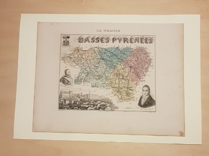
VUILLEMIN Alexandre ( 1812 - 1880 ) , Géographe
Carte du Département des BASSES PYRENEES , ( PYRENEES ATLANTIQUES )
Paris MIGEON 1882 In Plano Carte lithographiée en couleurs , dressée par Vuillemin d'après les cartes de Casini en 1853 , du dépôt de la guerre des Ponts et Chaussées et de la Marine . Extraite de l'Atlas : La France et ses Colonies . Edition de 1882 identique à celle de 1879 . Illustrée des villes , bourgs et cantons , communes ( parfois disparues ) , limites du département , limites des arrondissements , routes de 1ère et 2 ème classes , traverses , chemins de fer et stations , canaux , chemins de fer en construction ,entourée de personnages célèbres , de paysages , d'une vue de la ville principale , du blason , dont les textes sont écrits par Isidore . Format 22 cm x 18 cm ou sur marges de 34 cm x 24 cm , montée sur bristol crème de 42 cm x 30 cm . Envoyée en rouleau . - Cartes et Plans . - Une feuille , 250 gr.
Référence libraire : 022729
|
|
|
VUILLEMIN Alexandre ( 1812 - 1880 ) , Géographe
Carte du Département des BASSES PYRENEES , ( PYRENEES ATLANTIQUES )
Carte lithographiée en couleurs , dressée par Vuillemin d'après les cartes de Casini en 1853 , du dépôt de la guerre des Ponts et Chaussées et de la Marine . Extraite de l'Atlas : La France et ses Colonies . Edition de 1882 identique à celle de 1879 . Illustrée des villes , bourgs et cantons , communes ( parfois disparues ) , limites du département , limites des arrondissements , routes de 1ère et 2 ème classes , traverses , chemins de fer et stations , canaux , chemins de fer en construction ,entourée de personnages célèbres , de paysages , d'une vue de la ville principale , du blason , dont les textes sont écrits par Isidore . Format 22 cm x 18 cm ou sur marges de 34 cm x 24 cm , montée sur bristol crème de 42 cm x 30 cm . Envoyée en rouleau . - Cartes et Plans . - Une feuille , 250 gr.

|
|
|
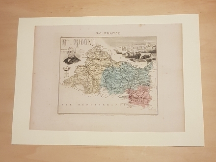
VUILLEMIN Alexandre ( 1812 - 1880 ) , Géographe
Carte du Département des BOUCHES DU RHÔNE
Paris MIGEON 1882 In Plano Carte lithographiée en couleurs , dressée par Vuillemin d'après les cartes de Casini en 1853 , du dépôt de la guerre des Ponts et Chaussées et de la Marine . Extraite de l'Atlas : La France et ses Colonies . Edition de 1882 identique à celle de 1879 . Illustrée des villes , bourgs et cantons , communes ( parfois disparues ) , limites du département , limites des arrondissements , routes de 1ère et 2 ème classes , traverses , chemins de fer et stations , canaux , chemins de fer en construction ,entourée de personnages célèbres , de paysages , d'une vue de la ville principale , du blason , dont les textes sont écrits par Isidore . Format 22 cm x 18 cm ou sur marges de 34 cm x 24 cm , montée sur bristol crème de 42 cm x 30 cm . Envoyée en rouleau . - Cartes et Plans . - Une feuille , 250 gr.
Référence libraire : 022731
|
|
|
VUILLEMIN Alexandre ( 1812 - 1880 ) , Géographe
Carte du Département des BOUCHES DU RHÔNE
Carte lithographiée en couleurs , dressée par Vuillemin d'après les cartes de Casini en 1853 , du dépôt de la guerre des Ponts et Chaussées et de la Marine . Extraite de l'Atlas : La France et ses Colonies . Edition de 1882 identique à celle de 1879 . Illustrée des villes , bourgs et cantons , communes ( parfois disparues ) , limites du département , limites des arrondissements , routes de 1ère et 2 ème classes , traverses , chemins de fer et stations , canaux , chemins de fer en construction ,entourée de personnages célèbres , de paysages , d'une vue de la ville principale , du blason , dont les textes sont écrits par Isidore . Format 22 cm x 18 cm ou sur marges de 34 cm x 24 cm , montée sur bristol crème de 42 cm x 30 cm . Envoyée en rouleau . - Cartes et Plans . - Une feuille , 250 gr.

|
|
|
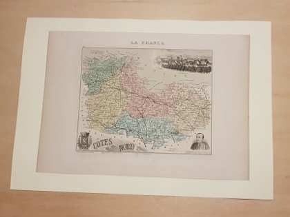
VUILLEMIN Alexandre ( 1812 - 1880 ) , Géographe
Carte du Département des CÔTES DU NORD ( CÔTES - D'ARMOR )
Paris MIGEON 1882 In Plano Carte lithographiée en couleurs , dressée par Vuillemin d'après les cartes de Casini en 1853 , du dépôt de la guerre des Ponts et Chaussées et de la Marine . Extraite de l'Atlas : La France et ses Colonies . Edition de 1882 identique à celle de 1879 . Illustrée des villes , bourgs et cantons , communes ( parfois disparues ) , limites du département , limites des arrondissements , routes de 1ère et 2 ème classes , traverses , chemins de fer et stations , canaux , chemins de fer en construction ,entourée de personnages célèbres , de paysages , d'une vue de la ville principale , du blason , dont les textes sont écrits par Isidore . Format 22 cm x 18 cm ou sur marges de 34 cm x 24 cm , montée sur bristol crème de 42 cm x 30 cm . Envoyée en rouleau . - Cartes et Plans . - Une feuille , 250 gr.
Référence libraire : 022740
|
|
|
VUILLEMIN Alexandre ( 1812 - 1880 ) , Géographe
Carte du Département des CÔTES DU NORD ( CÔTES - D'ARMOR )
Carte lithographiée en couleurs , dressée par Vuillemin d'après les cartes de Casini en 1853 , du dépôt de la guerre des Ponts et Chaussées et de la Marine . Extraite de l'Atlas : La France et ses Colonies . Edition de 1882 identique à celle de 1879 . Illustrée des villes , bourgs et cantons , communes ( parfois disparues ) , limites du département , limites des arrondissements , routes de 1ère et 2 ème classes , traverses , chemins de fer et stations , canaux , chemins de fer en construction ,entourée de personnages célèbres , de paysages , d'une vue de la ville principale , du blason , dont les textes sont écrits par Isidore . Format 22 cm x 18 cm ou sur marges de 34 cm x 24 cm , montée sur bristol crème de 42 cm x 30 cm . Envoyée en rouleau . - Cartes et Plans . - Une feuille , 250 gr.

|
|
|
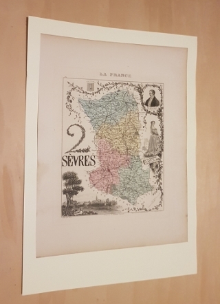
VUILLEMIN Alexandre ( 1812 - 1880 ) , Géographe
Carte du département des DEUX- SEVRES
Paris MIGEON 1882 In Plano Carte lithographiée en couleurs , dressée par Vuillemin d'après les cartes de Casini en 1853 , du dépôt de la guerre des Ponts et Chaussées et de la Marine . Extraite de l'Atlas : La France et ses Colonies . Edition de 1882 identique à celle de 1879 . Illustrée des villes , bourgs et cantons , communes ( parfois disparues ) , limites du département , limites des arrondissements , routes de 1ère et 2 ème classes , traverses , chemins de fer et stations , canaux , chemins de fer en construction ,entourée de personnages célèbres , de paysages , d'une vue de la ville principale , du blason , dont les textes sont écrits par Isidore . Format 22 cm x 18 cm ou sur marges de 34 cm x 24 cm , montée sur bristol crème de 42 cm x 30 cm . Envoyée en rouleau . - Cartes et Plans . - Une feuille , 250 gr.
Référence libraire : 022805
|
|
|
VUILLEMIN Alexandre ( 1812 - 1880 ) , Géographe
Carte du département des DEUX- SEVRES
Carte lithographiée en couleurs , dressée par Vuillemin d'après les cartes de Casini en 1853 , du dépôt de la guerre des Ponts et Chaussées et de la Marine . Extraite de l'Atlas : La France et ses Colonies . Edition de 1882 identique à celle de 1879 . Illustrée des villes , bourgs et cantons , communes ( parfois disparues ) , limites du département , limites des arrondissements , routes de 1ère et 2 ème classes , traverses , chemins de fer et stations , canaux , chemins de fer en construction ,entourée de personnages célèbres , de paysages , d'une vue de la ville principale , du blason , dont les textes sont écrits par Isidore . Format 22 cm x 18 cm ou sur marges de 34 cm x 24 cm , montée sur bristol crème de 42 cm x 30 cm . Envoyée en rouleau . - Cartes et Plans . - Une feuille , 250 gr.

|
|
|
VUILLEMIN Alexandre ( 1812 - 1880 ) , Géographe
Carte du Département des HAUTES - ALPES
Carte lithographiée en couleurs , dressée par Vuillemin d'après les cartes de Casini en 1853 , du dépôt de la guerre des Ponts et Chaussées et de la Marine . Extraite de l'Atlas : La France et ses Colonies . Edition de 1882 identique à celle de 1879 . Illustrée des villes , bourgs et cantons , communes ( parfois disparues ) , limites du département , limites des arrondissements , routes de 1ère et 2 ème classes , traverses , chemins de fer et stations , canaux , chemins de fer en construction ,entourée de personnages célèbres , de paysages , d'une vue de la ville principale , du blason , dont les textes sont écrits par Isidore . Format 22 cm x 18 cm ou sur marges de 34 cm x 24 cm , montée sur bristol crème de 42 cm x 30 cm . Envoyée en rouleau . - Cartes et Plans . - Une feuille , 250 gr.

|
|
|
VUILLEMIN Alexandre ( 1812 - 1880 ) , Géographe
Carte du Département des HAUTES - PYRENEES
Carte lithographiée en couleurs , dressée par Vuillemin d'après les cartes de Casini en 1853 , du dépôt de la guerre des Ponts et Chaussées et de la Marine . Extraite de l'Atlas : La France et ses Colonies . Edition de 1882 identique à celle de 1879 . Illustrée des villes , bourgs et cantons , communes ( parfois disparues ) , limites du département , limites des arrondissements , routes de 1ère et 2 ème classes , traverses , chemins de fer et stations , canaux , chemins de fer en construction ,entourée de personnages célèbres , de paysages , d'une vue de la ville principale , du blason , dont les textes sont écrits par Isidore . Format 22 cm x 18 cm ou sur marges de 34 cm x 24 cm , montée sur bristol crème de 42 cm x 30 cm . Envoyée en rouleau . - Cartes et Plans . - Une feuille , 250 gr.

|
|
|
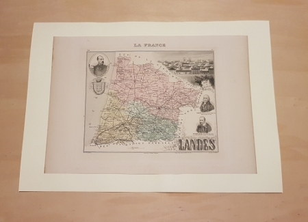
VUILLEMIN Alexandre ( 1812 - 1880 ) , Géographe
Carte du Département des LANDES
Paris MIGEON 1882 In Plano Carte lithographiée en couleurs , dressée par Vuillemin d'après les cartes de Casini en 1853 , du dépôt de la guerre des Ponts et Chaussées et de la Marine . Extraite de l'Atlas : La France et ses Colonies . Edition de 1882 identique à celle de 1879 . Illustrée des villes , bourgs et cantons , communes ( parfois disparues ) , limites du département , limites des arrondissements , routes de 1ère et 2 ème classes , traverses , chemins de fer et stations , canaux , chemins de fer en construction ,entourée de personnages célèbres , de paysages , d'une vue de la ville principale , du blason , dont les textes sont écrits par Barbier . Format 22 cm x 18 cm ou sur marges de 34 cm x 24 cm , montée sur bristol crème de 42 cm x 30 cm . Envoyée en rouleau . - Cartes et Plans . - Une feuille , 250 gr.
Référence libraire : 022764
|
|
|
VUILLEMIN Alexandre ( 1812 - 1880 ) , Géographe
Carte du Département des LANDES
Carte lithographiée en couleurs , dressée par Vuillemin d'après les cartes de Casini en 1853 , du dépôt de la guerre des Ponts et Chaussées et de la Marine . Extraite de l'Atlas : La France et ses Colonies . Edition de 1882 identique à celle de 1879 . Illustrée des villes , bourgs et cantons , communes ( parfois disparues ) , limites du département , limites des arrondissements , routes de 1ère et 2 ème classes , traverses , chemins de fer et stations , canaux , chemins de fer en construction ,entourée de personnages célèbres , de paysages , d'une vue de la ville principale , du blason , dont les textes sont écrits par Barbier . Format 22 cm x 18 cm ou sur marges de 34 cm x 24 cm , montée sur bristol crème de 42 cm x 30 cm . Envoyée en rouleau . - Cartes et Plans . - Une feuille , 250 gr.

|
|
|
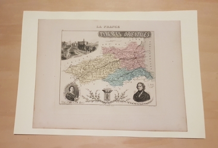
VUILLEMIN Alexandre ( 1812 - 1880 ) , Géographe
Carte du département des PYRENEES ORIENTALES
Paris MIGEON 1882 In Plano Carte lithographiée en couleurs , dressée par Vuillemin d'après les cartes de Casini en 1853 , du dépôt de la guerre des Ponts et Chaussées et de la Marine . Extraite de l'Atlas : La France et ses Colonies . Edition de 1882 identique à celle de 1879 . Illustrée des villes , bourgs et cantons , communes ( parfois disparues ) , limites du département , limites des arrondissements , routes de 1ère et 2 ème classes , traverses , chemins de fer et stations , canaux , chemins de fer en construction ,entourée de personnages célèbres , de paysages , d'une vue de la ville principale , du blason , dont les textes sont écrits par Isidore . Format 22 cm x 18 cm ou sur marges de 34 cm x 24 cm , montée sur bristol crème de 42 cm x 30 cm . Envoyée en rouleau . - Cartes et Plans . - Une feuille , 250 gr.
Référence libraire : 022787
|
|
|
 Recevoir par e-mail
 Télécharger en PDF
 Flux RSS


