|
ART ROMAN par H. DECKER.
L'art roman en Italie. 263 photos (héliogravures) de l'auteur avec légendes et cartes.
Paris, Braun & Cie 1958. Bel exemplaire relié, reliure pleine toile, fort in-4, 88 pages + planches.
书商的参考编号 : AUB-5610
|
|
|
ARTHUR Gilles
La magie c'est facile avec Gilles Arthur. Collection : Fleurus idées, 112/62.
Paris, Editions Fleurus, 1984. 15 x 16, 60 pp., photos en couleurs, nombreux dessins, broché, bon état.
书商的参考编号 : 36731
|
|
|
ARTEZAY de LA SAUVAGÈRE (d'). MANUSCRIT.
Plan de Béthune.
1727/1728. En deux feuilles jointes de 485 x 703 mm.
书商的参考编号 : LBW-4136

|
|
|
ARTARIA
Plans et Vues de villes.- Torino, Genova, Venezia, Bologna, Milano, Roma, Firenze, Livorno, La Valetta, Palermo, Napoli.
1840 12 sections montées sur toile et pliées, formant une carte de 520 x 590 mm., Vienna Artaria ca. 1840
书商的参考编号 : 16326
|
|
|
Arthur Lee Jacobson
Trees of Seattle: The Complete Tree-Finder's Guide to the City's 740 Varieties
Book is in excellent condition, with one crease at spineas only blemish to exterior. Binding is solid and square, covers have sharp corners, exterior shows no blemishes, text/interior is clean and free of marking of any kind. 433 pages with color photo section. Previous owner's name inside.

|
|
|
Artist Not Stated
Map of Peace River and Grand Prairie District, Alberta, January 1929 - Homesteading Map
33" x 25" coloured map. "Showing Dominion Lands Vacant. For complete information and regulations governing homestead entry apply to agent at Peace River..." Coal mines, water developed, other minerals, undeveloped minerals, oil and gas wells, power transmission lines and main roads indicated. Unmarked with moderate wear. A quality copy of this excellent homesteading memento of the Peace River/Grande-Prairie District. Book

|
|
|
Artist Unknown
1889 Color Map of the Lower 48 States of the United States (U.S.A.) Indicating Divisions of Standard Time
Vintage color map. Includes table of cities located in the Inter-Colonial, Eastern, Central, Mountain, and Pacific Standard Time Zones. Indicates how many minutes faster or slower these locations are than Solar Time. Outer dimensions: 10.75" x 14.5". Unmarked with moderate wear and soiling. Book

|
|
|
Artist Unknown
1889 Map of the Solar System, Illustrating Comparative Distances of the Planets From the Sun
Vintage color map. Includes illustrations of comparative planet sizes, neap tides, spring tides, lunar eclipse and solar eclipse. Outer dimensions: 10.75" x 14.5". Unmarked with Light wear. Book

|
|
|
Ascherson, Neal
Black Sea
In this study of the fateful encounters between Europe and Asia on the shores of a legendary sea, Neal Ascherson explores the disputed meaning of community, nationhood, history, and culture in a region famous for its dramatic conflicts. What makes the Back Sea cultures distinctive...is the way their component parts came together over the millennia to shape unique communities, languages, religions, and trade. 306. map. bibliography, index. Book
|
|
|
Ashbee, Charles Robert [Ed.]
Walk About Sion and Go Around About the Towers Thereof [2 VOLUMES IN ONE] Jerusalem 1918-1920; Jerusalem 1920-1922 - Being the Records of the Pro Jerusalem Council during the Period of the British Military Administration
FIRST EDITION, TWO VOLUMES BOUND TOGETHER. This is a detailed survey of the city of Jerusalem during the start of the British Mandate in Palestine. Includes a large number of drawings, photographs, schematics and fold-out maps of the city, accompanied by essays in English and French. Editor Charles Ashbee was an architect, and paid close attention to the many religious edifices in the city. 285x230mm, XV+87+XVI+109 pages (only text pages are numbered). Brown Quarter-leather hardcover with large black illustration on front board. [CONDITION:] Cover edges and corners worn. Cover boards slightly dirty. Previous owner's inscription in Hebrew (dated 1969) on front endpaper. Some pages slightly age-stained. [SUMMARY:] This tandem-bound copy of a fascinating collection of textual and visual information is overall in very good internal condition; good external condition.
|
|
|
Ashley, George H.
THE SCENERY OF PENNSYLVANIA. Its Origin and Development based on recent studies of Physiographic and Glacial History.
pp. ix, 91 + Large folding geological map. Illustrated with numerous maps and photographs. Tall 8vo. Original printed wraps. Inked ownership and stamp of O. F. Stambaugh, Department of Chemistry, Elizabethtown College on front cover. Spine sightly worn. Pennsylvania Geological Survey Fourth Series Bulletin G 6. PA PAMPH 20_10 BX3
|
|
|
ASIAN MAPS
Map of Asia.
Edward Stanford London c.1900. . Hand-coloured lithograph map dissected and mounted on linen folding into publisher's yellow advertisements and original green cloth covers. Edward Stanford, London, [c.1900]. hardcover
书商的参考编号 : 50951
|
|
|
Aspinall Oglander C. F. And Photographs Drawings And Maps
Military Operations Gallipoli Set Official History of the War
Hardcover. Very good. 0 Imperial War Museum in association with The Battery Press 1992 V1. 380 pages V2. 517 pages red cloth hard covers with gold spine stamping no owner's mark or underlining tight and square very light wear. hardcover
书商的参考编号 : T87-ODE-3EP ???????? : 089839175x 9780898391756
|
|
|
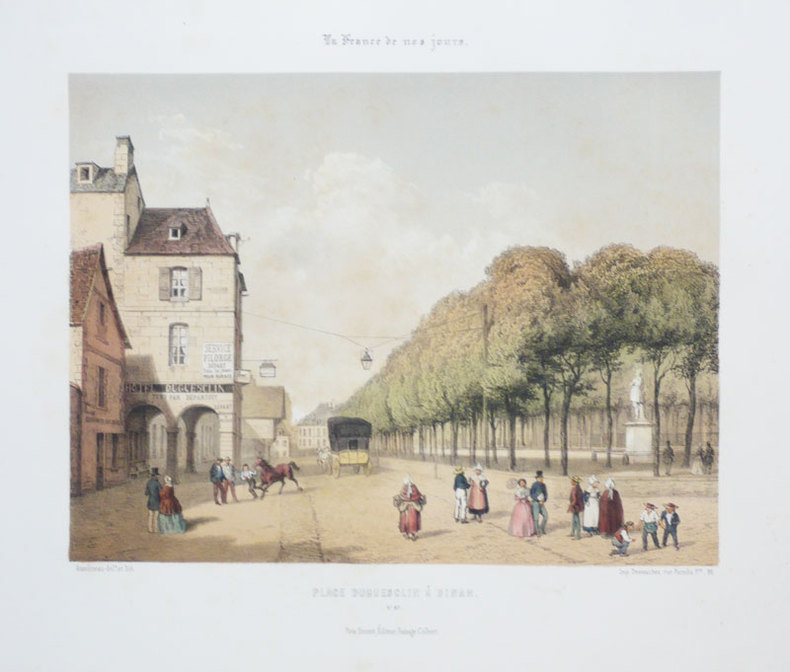
ASSELINEAU (Léon-Auguste);
[DINAN] Place Duguesclin à Dinan.
Paris F. Sinnett circa 1855 245 x 264 mm.
书商的参考编号 : LBW-898
|
|
|
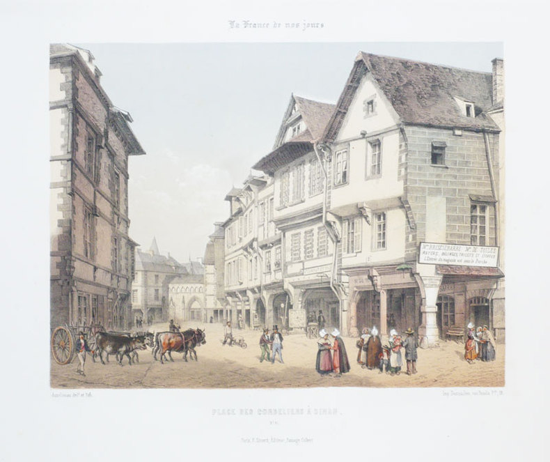
ASSELINEAU (Léon-Auguste);
[DINAN] Place des Cordeliers à Dinan.
Paris F. Sinnett circa 1855 250 x 267 mm.
书商的参考编号 : LBW-897
|
|
|
ASSELINEAU (Léon-Auguste);
[DINAN] Vue de Dinan prise de la Vallée des Noyers.
Paris F. Sinnett circa 1855 250 x 263 mm.
书商的参考编号 : LBW-896

|
|
|
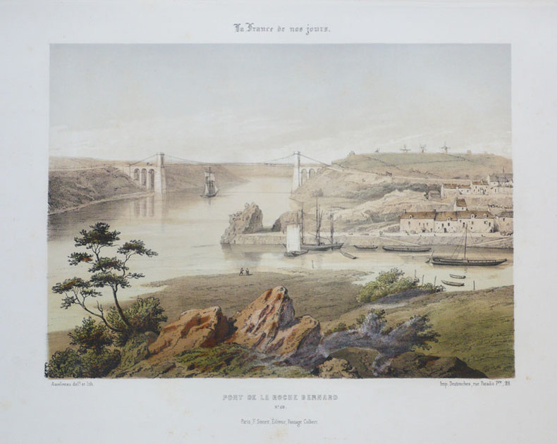
ASSELINEAU (Léon-Auguste);
[LA ROCHE BERNARD] Pont de La Roche Bernard.
Paris F. Sinnett circa 1855 242 x 280 mm.
书商的参考编号 : LBW-891
|
|
|
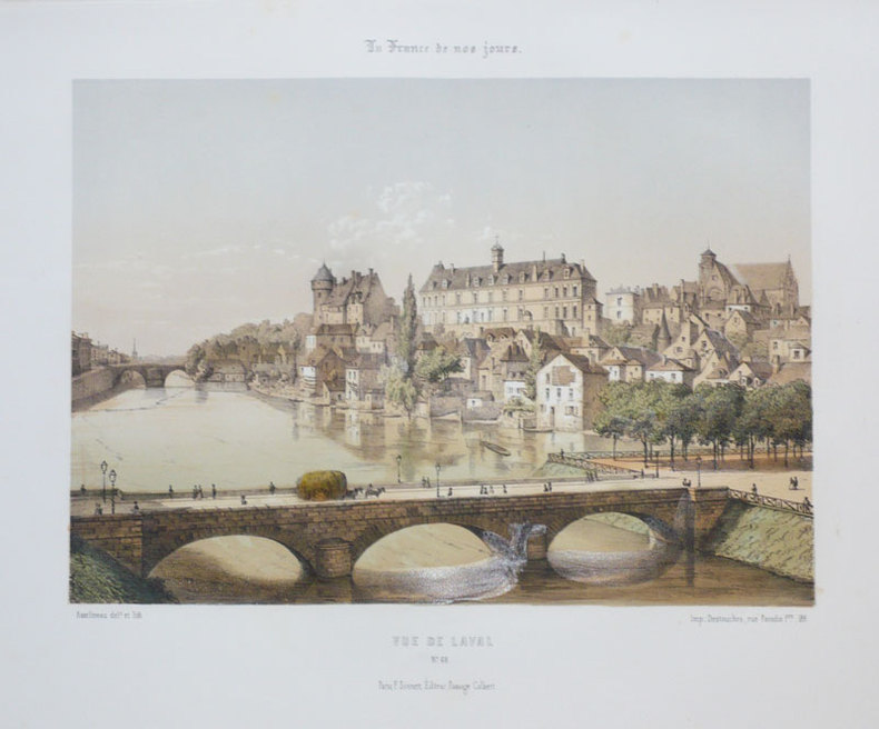
ASSELINEAU (Léon-Auguste);
[LAVAL] Vue de Laval.
Paris F. Sinnett circa 1855 242 x 275 mm.
书商的参考编号 : LBW-892
|
|
|
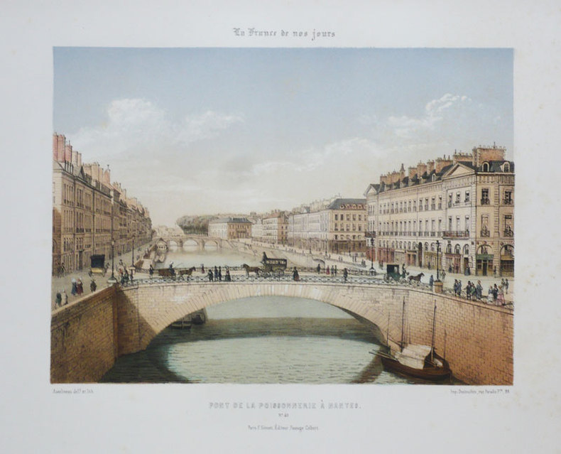
ASSELINEAU (Léon-Auguste);
[NANTES] Pont de la Poissonnerie à Nantes.
Paris F. Sinnett circa 1855 240 x 275 mm.
书商的参考编号 : LBW-884
|
|
|
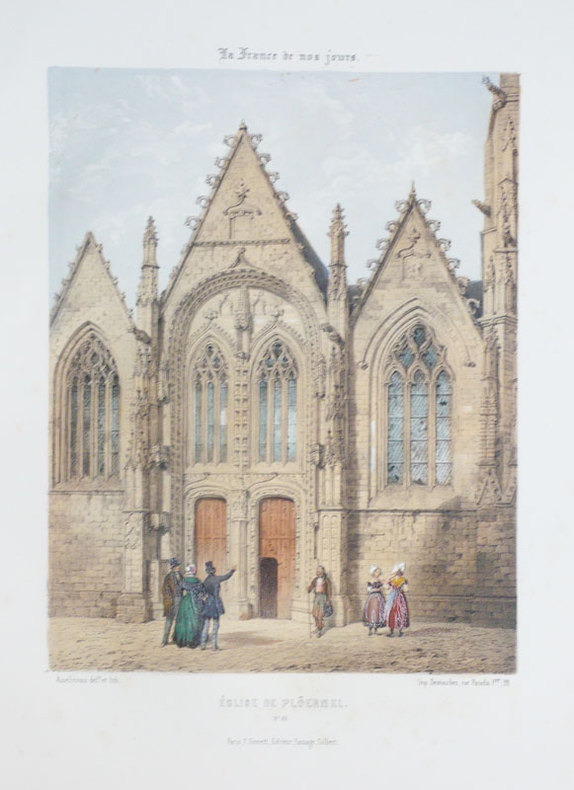
ASSELINEAU (Léon-Auguste);
[PLOERMEL] Eglise de Plöermel.
Paris F. Sinnett circa 1855 302 x 202 mm.
书商的参考编号 : LBW-893
|
|
|
ASSELINEAU (Léon-Auguste);
[RENNES] Palais de l'université à Rennes.
Paris F. Sinnett circa 1855 240 x 275 mm.
书商的参考编号 : LBW-872

|
|
|
ASSELINEAU (Léon-Auguste);
[RENNES] Vue du théâtre, à Rennes.
Paris F. Sinnett circa 1855 235 x 276 mm.
书商的参考编号 : LBW-875
|
|
|
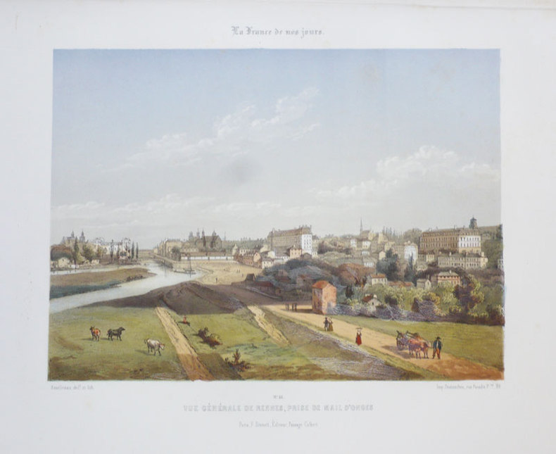
ASSELINEAU (Léon-Auguste);
[RENNES] Vue générale de Rennes, prise de Mail d'Onges.
Paris F. Sinnett circa 1855 243 x 274 mm.
书商的参考编号 : LBW-876
|
|
|
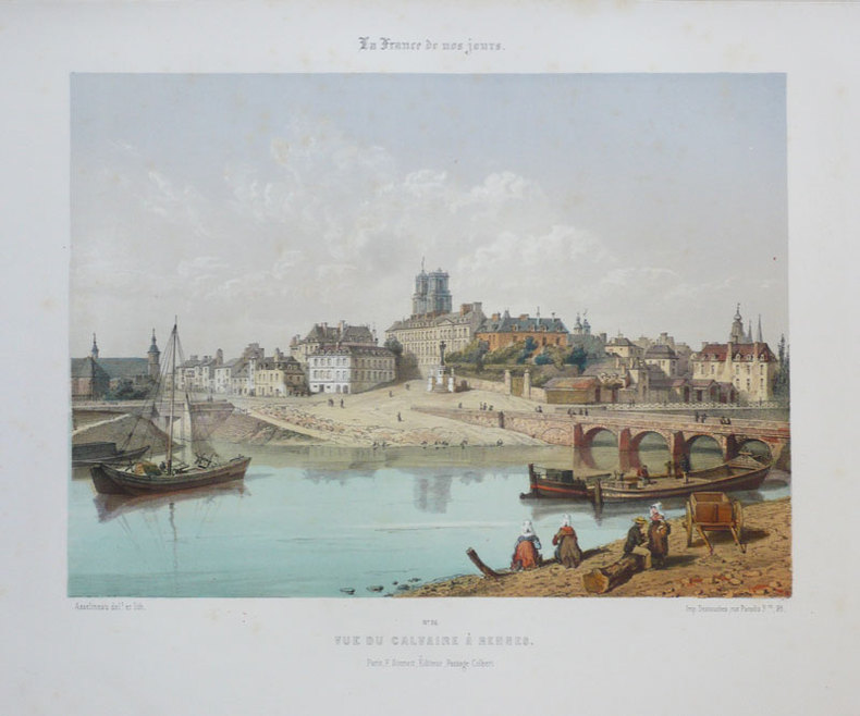
ASSELINEAU (Léon-Auguste);
[RENNES] Vue du Calvaire à Rennes.
Paris F. Sinnett circa 1855 242 x 276 mm.
书商的参考编号 : LBW-877
|
|
|
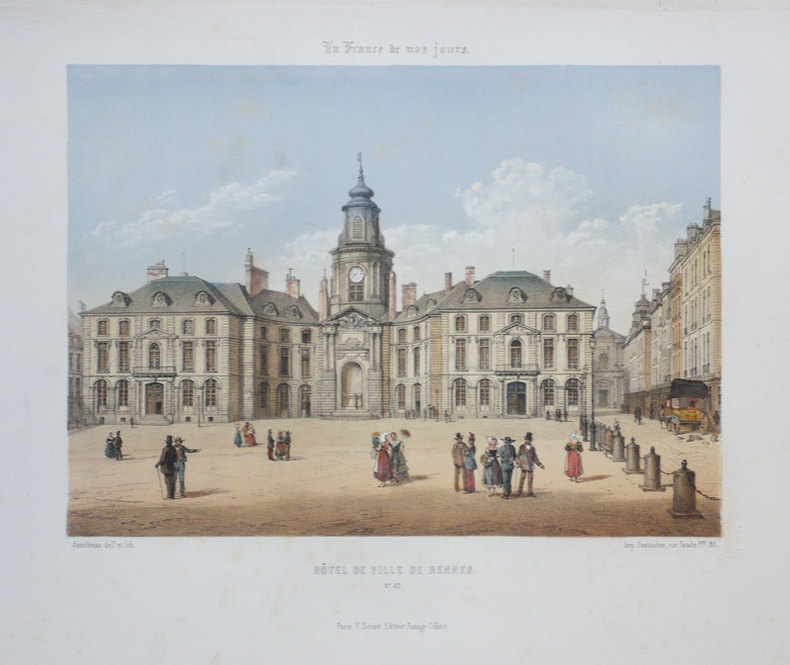
ASSELINEAU (Léon-Auguste);
[RENNES] Hôtel de Ville de Rennes.
Paris F. Sinnett circa 1855 247 x 276 mm.
书商的参考编号 : LBW-883
|
|
|
ASSELINEAU (Léon-Auguste);
[RENNES] Vue de la place du Palais de justice à Rennes.
Paris F. Sinnett circa 1855 237 x 276 mm.
书商的参考编号 : LBW-874

|
|
|
ASSELINEAU (Léon-Auguste);
[VANNES] La Cathédrale de Vannes.
Paris F. Sinnett circa 1855 235 x 272 mm.
书商的参考编号 : LBW-894

|
|
|
ASSELINEAU (Léon-Auguste);
Chambord. Château royal de Chambord.
Paris F. Sinnett circa 1855 236 x 277 mm.
书商的参考编号 : LBW-867

|
|
|
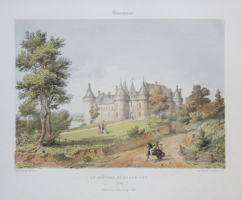
ASSELINEAU (Léon-Auguste);
Chaumont. Le château de Chaumont.
Paris F. Sinnett circa 1855 235 x 275 mm.
书商的参考编号 : LBW-868
|
|
|
ASSELINEAU (Léon-Auguste);
Chenonceaux. Le château de Chenonceaux.
Paris F. Sinnett circa 1855 232 x 275 mm.
书商的参考编号 : LBW-870

|
|
|
Association bretonne- Classe d'Archéologie - Texte & 3 Grandes Cartes dépliantes couleurs de la Bretagne Armoricaine au moment de l'Occupation romaine dressées par R. POCARD-KERVILLER
Etude critique sur la Géographie de la Presquîle Armoriquaine
Saint-Brieuc Imprimerie-lithographie L.Prud'home 1873 - in-8, broché - Seizième session tenue à Quimper en 1873 - Comptes-rendus - Procès-verbaux - Mémoires - 3 Grandes Cartes dépliantes couleurs de la Bretagne Armoricaine au moment de l' occupation romaine dressées par R. POCARD-KERVILLER -187 pages - Ex. non coupé - Très bon exemplaire
书商的参考编号 : 5573
|
|
|
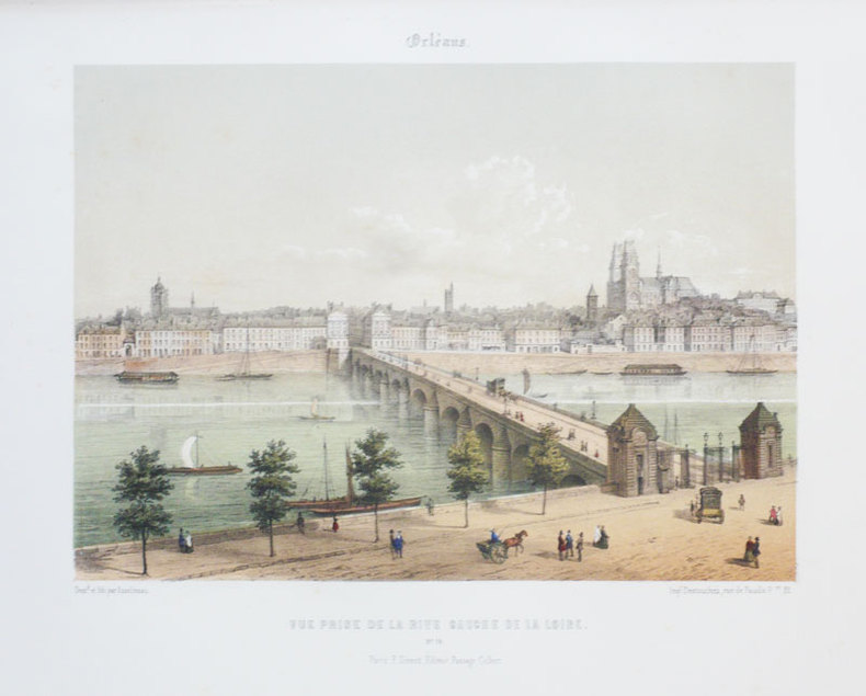
ASSELINEAU (Léon-Auguste);
Orléans. Vue prise de la rive gauche de la Loire.
Paris F. Sinnett circa 1855 242 x 275 mm.
书商的参考编号 : LBW-888
|
|
|
ASSELINEAU (Léon-Auguste);
Rouen. Vue de Rouen prise de St. Sever.
Paris F. Sinnett circa 1855 242 x 276 mm.
书商的参考编号 : LBW-889
|
|
|
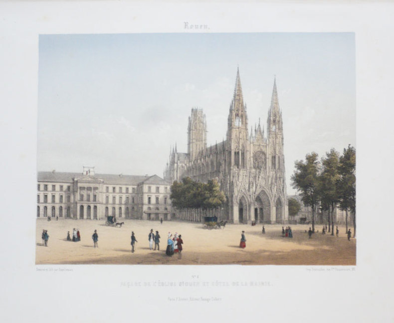
ASSELINEAU (Léon-Auguste);
Rouen. Façade de l'église St. Ouen et Hôtel de la mairie.
Paris F. Sinnett circa 1855 242 x 276 mm.
书商的参考编号 : LBW-890
|
|
|
Astronomical instruments.
Sphaera armillaris. Instrumentum artificiale Orrery ab inventore appellatum. Augsburg, Tobias Conrad Lotter, 1774.
Large Folio. Coloured copper engraving.
|
|
|
Atar arts graphiques
Plan de Gen�ve
Gen�ve: Union de banques suisses 1967. Map. Very Good/No Jacket. Map 40 x 72 cm. folded to 21 x 11 cm. Text and legend in French German Italian English and Spanish. Ancillary map on verso: Canton de Gen�ve at Zones Franches. Hotel name stamped on title panel otherwise clean and unmarked Union de banques suisses unknown
书商的参考编号 : 800179
|
|
|
ATHENA (Mme)
Régles des jeux de cartes
Paris, Lib. des Petits chefs-d'oeuvre, s.d. (c.1920), in-12, carré, 120, (8)pp, broché, Figures dans les texte. Petit recueil populaire. très bel exemplaire! carré, 120, (8)pp.
书商的参考编号 : 27150
|
|
|
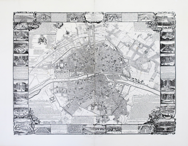
ATLAS des ANCIENS PLANS de PARIS & FER (Nicolas de).
Le nouveau plan de Paris dressé sur les mémoires de M.r Jouvin de Rochefort, trésorier de France. Corigé, augmenté, et enrichi des veües de Versailles, et de ses bosquets, de Meudon, Fontaine-Bleau, St. Germain, et de quelques autres maisons royalles, situées aux environs.
Paris, Imprimerie Nationale, [1697-1880]. En 2 feuilles jointes de 605 x 782 mm.
书商的参考编号 : LBW-4001
|
|
|
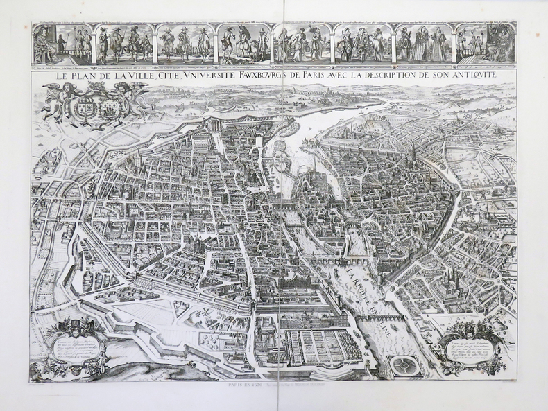
ATLAS des ANCIENS PLANS de PARIS & TAVERNIER (Melchior).
Le plan de la ville, cité, université, fauxbourgs de Paris avec la description de son antiquité.
Paris, Imprimerie Nationale, [1630-1880]. En 2 feuilles jointes et montées sur toile, formant un plan de 553 x 725 mm.
书商的参考编号 : LBW-3996
|
|
|
ATLAS des ANCIENS PLANS de PARIS & VASSALLIEU dit NICOLAY (Benedit).
Portrait de la ville, cité, et université de Paris avec les faubours di celle.
Paris, Imprimerie Nationale, [1609-1880]. En deux feuilles jointes et montées sur toile de 620 x 776 mm.
书商的参考编号 : LBW-4000

|
|
|
ATLAS - (BRION DE LA TOUR, LOUIS).
Atlas, et Tables élémentaires de Géographie, ancienne et moderne " Adopté par plusiuers Ecoles Royales Militaires. Nouvelle Édition.
Paris, J. Barbou, 1783. Large 8vo. (18,5x13,5 cm.). Contemp. blue boards. Covers with wear and some scratches. Backstrip gone. Old owners names on title.V,(49) pp. and 20 double-page engraved maps, of which 19 are handcoloured in outline (paper measuring 18x22 cm.). Textlvs. with traces of use. 2 maps with some smaller inkspots. Maps fine apart from some browning to margins. Maps unsigned, but after the listing of the maps (verso of titlepage) is printed ""Ces Cartes ont été gravées par M. André sur les dessins de M. Brion.""
|
|
|
ATLAS - ANDREE, (RICHARD).
Andrees allgemeiner Handatlas in 91 Haupt-und 86 Nebenkarten nebst vollständigem alphabetischen Namenverzeichnis. Dritte, völlig neubearbeitete und vermehrte Auflage. Herausgegeben von der Geographischen Anstalt von Velhagen & Klasing in Leipzig.
Bielefeld und Leipzig, Velhagen & Klasing, 1893. Folio. In contemporary half calf. Fine. 140 map + 150 pp.
|
|
|
ATLAS - BUUL, A.
Verdens Atlas udarbeidet efter de nyeste og bedste Kilder. Tegnet og graveret af A. Bull. Gjennemseet og revideret af P.C. Friedenreich.
Kjöbenhavn, Chr. Steen & Søn, (1849-61). Titelbladet uden år. Stor folio. Samt. hldrbd. Forperm med orig. bogtrykt omslag påsat. Udvendig noget slidt og med brugsspor. Litograferet titelblad med trykt indholdsfortegnelse over atlassets 20 dobbeltsidede foliokort, alle litograferede og håndkoloreret (hvert målende ca 52x64 cm). Her og der med lidt brunpletter, særligt marginer, men indvendigt iøvrigt i god stand. Kortene er litograferede hos Emil Bærentzen & Co. Lith. Institut og alle daterede mellem 1849 og 1861, opsat på false.
|
|
|
ATLAS - PHILIPPE JEAN COULIER
Atlas général des Phares et Fanaux à l'usage des Navigateurs,... Publié sous les Auspices de S.A.R.Mgr le Prince de Joinville. 23 Parts. (All published).
Paris, Chez l'Auteur - Saint-Petersburg, Issakoff, 1844-48. Small folio. (35 x 27 cm.). In a worn contemp. hcalf. Spine cracked and broken. Boards detached. All parts stitched, a few loose. All parts uncut and unopened. All parts clean and fine. Each part separately paginated and with own title-page. Text to each part (from 8-12 pp.). Each part having a large folded engraved general map and from 11 to 27 engraved folio-maps. In all 292 textpages and 441 engraved maps.
|
|
|
ATLAS DEUTSCHLAND - ATLAS GERMANY.
Topographisch-militairischen Charte von Deutschland in 254. Sectionen unternommen von dem Geographischen Institute zu Weimar. (Nur 128 Sectionen).
Weimar, Geographischen Institute, (1807-13). Folio-oblong. Loose sheets in a box. Containg 128 engraved maps, each measuring ca. 30 x 45 cm. Mostly clean and fine, but some with annotations, some with browning and some with traces of use.
|
|
|
ATLAS MIGEON
Carte d?partementale couleurs : Ain. Fin XIXe.
Feuille 34 x 26 cm. Rousseurs.
|
|
|
ATLAS MIGEON
Carte d?partementale couleurs : Alpes maritimes. Fin XIXe.
1 feuille 34 x 26 cm.
|
|
|
ATLAS MIGEON
Carte d?partementale couleurs : Bouches du Rh?ne. Fin XIXe.
1 feuille 34 x 26 cm.
|
|
|
ATLAS MIGEON
Carte d?partementale couleurs : H?rault Fin XIXe.
1 feuille 25x43 cm.
|
|
|
ATLAS MIGEON
Carte d?partementale couleurs : Haute Sa?ne. Fin XIXe.
1 feuille 36 x 42 cm.
|
|
 ?????????
 ?????PDF???
 RSS feed


