|
Landtaffel ettlicher Göwen des Schwabenlands darinn die newen Nammen aller Stätten/ Fläcken [...] verzeichnet werden.
26 x 33,5 cm. Blatt: 32 x 38 cm. *Landkarte von Schwaben mit der Donau am Oberrand, mit der Altmühl links und der Brenz rechts, im Mittelpunkt liegt Nördlingen. Landkarten de
|
|
|
Langnau und Umgebung. (Emmental). Gef. Topographische Karte. I:10.000
Bern, Eidg. Landestopographie, 1929, in-8vo, gef. , original Titel
Referencia librero : 129534aaf
|
|
|
Lausanne et environs.
Berne, Service topographique fédéral, 1944. Carte au 1:25 000, au format ouvert de 94 x 79 cm.
Referencia librero : 18660

|
|
|
Lausanne et environs.
Berne, Service topographique fédéral / Atlas topographique de la Suisse, 1934. Carte au 1:25 000, au format ouvert de 94 x 97,5 cm. En belle condition.
Referencia librero : 19309

|
|
|
Le beau Jura - Der schöne Jura.
Neuchâtel, Chocolat Suchard S.A., coll. Mon cher pays - My liebi Schwyz, albums photos. Série XIII, 1939. Rare petite pochette au format 9 x 6 cm., premier plat ajouré, second plat imprimé, avec languette de fermeture. En très belle condition. 9 photographies en noir à collectionner et à coller ensuite dans le volume éponyme. Bien complet du petit papillon rose qui explique l'absence de la dixième photographie qui devrait trouver place dans ce portfolio: "Les photos (n° et série) ont une valeur spéciale au point de vue stratégique. C'est pour cette raison que les autorités militaires ont interdit pour le moment leur distribution". N'oublions pas que nous sommes en 1939...
Referencia librero : 5248

|
|
|
Le Briançonnais 20 cartes détachables
|
|
|
LE COLLECTIONNEUR FRANCAIS
Du N° 1 (Mars 1965) au N° 97 (Décembre 1973). Collection complète de 97 revues, en un volume, relié demi-maroquin rouge.
Referencia librero : J92
|
|
|
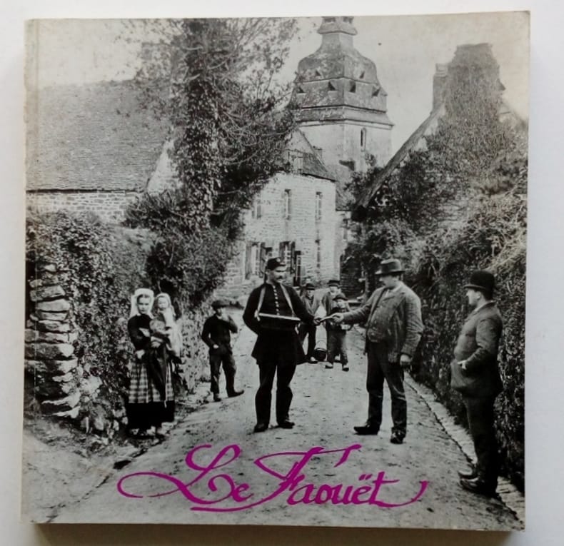
LE FAOUET . Ouvrage de 150 photos ou cartes v 1900 avec texte explicatif
1995 LE FAOUET.Quistinic,L'aventure carto ,1995, in8 carré(20x20) broché ,143ppOuvrage collectif . Près de 150 photos ou cartes postales du début du XXè classées par quartier et par thème avec un texte explicatif .
Referencia librero : 165627
|
|
|
Le folklore de l'auvergne et du velay. (= Contributions au folklore des provinces de France, Tome 5).
Paris: Maisonneuve 1942. (8), 375 Seiten. Avec 10 cartes folkloriques et 2 photos. Gr. 8° (22,5-25 cm). Orig.-Broschur. [Softcover / Paperback].
Referencia librero : 3080539

|
|
|
le Jeu de l'Hombre, augmenté des décisions nouvelles sur les difficultez et incidens de ce jeu. L prix est de 30 sols
Pierre Ribou, 1709 in-12 (16 x 10 cm), 6 ff., 166 pp. 6 ff., 33 pp., 1 ff. reliure d'époque, veau brun, dos à 5 nerfs orné, (pièce de titre absente), dentelle or sur les coupes. Cette édition est la sixième. Nombreuses figures explicatives dans le texte, manque le frontispice, ex-libris manuscrit : "Madame de Bellemare la jeune" (légères traces d'usage).
Referencia librero : 003375
|
|
|
LE MONDE-N°7438-JEUDI 12 DECEMBRE 1968
32 PAGES FORMAT 34 CM X 50 CM-LA MORT DE KARL BARTH, SUITE P8-CANADA LES AUTORITES FEDERALES VEULENT GARANTIR L'EGALITE DES ANGLOPHONES ET FRANCOPHONES DANS L'ENSEIGNEMENT, PAR JEAN TAINTURIER-LES DEBATS AU PALAIS DU LUXEMBOURG M. LE THEULE PROMET QUE L'ORTF "JOUIRA D'UNE TRES GRANDE AUTONOMIE"-LA CORSE ET L'EMPEREUR DISPUTES AUTOUR D'UN BICENTENAIRE-EDGAR POE L'ANGE DU BIZARRE-UN PEINTRE HORS DU TEMPS LA LENTEUR DE LOUIS FERNANDEZ-CORRESPONDANCE ET CATALOGUE RAISONNE NICOLAS DE STAEL AU COMPLET, PAR JACQUES MICHEL-AVEC R. CAILLOIS ET J.P. SEGUIN LE PETIT MONDE DES CARTES A JOUER, PAR ANDRE CHASTEL-ENCART POUR MICHELE MORGAN A LA GALERIE DINA VIERNY-VENTE AUX ENCHERES DE DEUX CABARETS DE LA RIVE GAUCHE, "LA FONTAINE DES QUATRE SAISONS", PIERRE PREVERT, "LA GRANDE SEVERINE"-BARRAULT ET RABELAIS A L'ELYSEE MONTMARTRE, PAR CLAUDE SARRAUTE-A QUIMPER PEINES D'AMENDE POUR M. EDOUARD LECLERC POUR REFUS D'AFFILIATION DE SON PERSONNEL A UN SERVICE MEDICAL DE TRAVAIL
Referencia librero : ABE-15813401910

|
|
|
LE VIEUX TEIL ET ENVIRONS. 40 cartes postales 1900-1925. Photocopies de la collection de Paul Nègre auto-éditeur.
Le Teil, chez l'auteur, sans date (fin XXème). Agraphé. in-8 de 20 feuillets (40 cartes postales photocopiées).
Referencia librero : 20493
|
|
|
Leipzig. Stadtplan im Maßstab 1:24.000. Farbiger Holzstich.
Leipzig, F. A. Brockhaus, [ca. 1901. Bildgröße 20,5 x 27 cm. Unter Feinkartonpassepartout.
Referencia librero : 76508

|
|
|
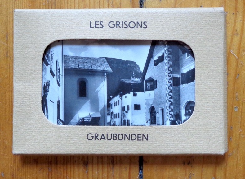
Les Grisons - Graubünden.
Neuchâtel, Chocolat Suchard S.A., coll. Mon cher pays - My liebi Schwyz, albums photos. Série VIII, 1939. Rare petite pochette au format 9 x 6 cm., premier plat ajouré, second plat imprimé, avec languette de fermeture. En très belle condition. 10 photographies en noir à collectionner. Il existait un volume éponyme dans lequel il s'agissait de les coller.
Referencia librero : 5252
|
|
|
Les obsèques - le Président de la République et les membres du gouvernement
Carte postale ancienne | Etat : Bon état général, écritures (Ref.: ref97078)
Referencia librero : 9782845227141
|
|
|
Les provinces des Pays-Bas Catholiques distinguées suivant qu'elles sont présentement partagées entre le Roy de France, le Roy d'Espagne, et les Estats Généraux des Provinces-Unies. Grenzkolorierter Kupferstich. Mit 3 Kartuschen u. lateinischer Titelkopfleiste. Von H. Jaillot.
Paris, H. Jaillot, 1693. Blattgröße ca. 54 x 65 cm, Bildgröße ca. 48 x 61 cm.
Referencia librero : 52184

|
|
|
Les PTT vus par les illustrateurs - n°1 à 8 soit 24 cartes
| Etat : Très bon état général. (Ref.: Ref98978)
Referencia librero : 9782845235950
|
|
|
LES PYRÉNÉES (Perpignan-Barcelone) - Paris 1951
Paris, Edit. Blondel La Rougery, 1951. Mapa topográfico. 1:320.000. Plano ciudades. 36 p. Firma antiguo proopietario. 8º. Rústica editorial ilustrada, algo rozada. Buen ejemplar. Livre en français.
|
|
|
LES SAINTS EVANGILES. Traduits de la Vulgate par M l' Abbé Dassange. Illustrés par MM T Johannot , Cavelier , Gérard-Séguin et Brévière. 2 tomes.
Paris Editeur L. Curmer 1836 2 volumes grand in-8 Pleine reliure d'époque
Referencia librero : 010499
|
|
|
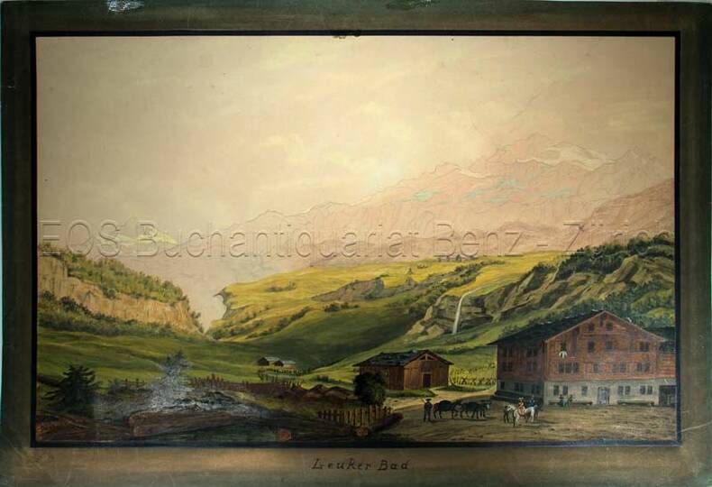
Leukerbad.
Kol. Aquatinta auf festem Papier. Bildgrösse: 27,8 x 43 cm. Blattgrösse: 32,3 x 47 cm.
Referencia librero : 805CG
|
|
|
Leukerbad.
o.J. Kol. Aquatinta auf festem Papier. Bildgrösse: 27,8 x 43 cm. Blattgrösse: 32,3 x 47 cm. + Wichtig: Für unsere Kunden in der EU erfolgt der Versand alle 14 Tage verzollt ab Deutschland / Postbank-Konto in Deutschland vorhanden +, Abb.
Referencia librero : 805CG

|
|
|
Libyan Arab Republic Tourist Road Map 1976
Colour map in card covers. eng
|
|
|
LIENA - Madrid 1950 - Mapa
Madrid, Dirección General del Instituto Geográfico y Catastral, 1950. 2ª edición. Mapa publicado por sectores (sector 147). Escala 1:50.000. 56x76 cms. Mapa entelado y plegado. Buen ejemplar.
|
|
|
Ligne pittoresque du chemin de fer Le Pouzin-Aubenas . Le tunnel , coté de Privas ( A droite la route au passage du col ) .N° 5 de la série .
Aubenas , Artige fils éditeur . 1 Reproduction et agrandissement d'une carte postale , XIXeme . 18X24 , sous verre .
Referencia librero : 147
|
|
|
Ligne pittoresque du chemin de fer Le Pouzin-Aubenas , passage de la montagne qui glisse .N° 2 de la série .
Aubenas , Artige fils , éditeur . 1 Reproduction et agrandissement d'une carte postale XIXeme . 24X18 , sous verre .
Referencia librero : 149
|
|
|
Lincoln & Area Street Plan and Guide
8vo, 16 pages, one folded plan. eng
|
|
|
Lisbonne (Plan de - Grundriss von).
s.l., s.d. (vers 1800) 34 x 44 cm, carte gravée tirée sur papier bleuâtre, ‘Lisbonne’ en couleurs, titre en haut à gauche ‘Superficie 1, 500,000 Toises, Echelle de 600 Toises , a droite en haut: N.B. On a indiqué par une teinte differente la partie de la ville qui’à été rebatie depuis le tremblementr de terre de 1755, 1 plan de Lisbonne
Referencia librero : 116355aaf
|
|
|
Lissabon. Stadtplan im Maßstab 1: 22.000. Farbige Lithographie.
Leipzig, F. A. Brockhaus, [ca. 1905]. Bildgröße 13,5 x 22,5 cm. Unter Feinkartonpassepartout.
Referencia librero : 77014

|
|
|
Livadien, der Peloponnes und die Jonischen Inseln. Stahlstich.
[ca. 1820]. Bildgröße 17 x 14,5 cm. Unter Passepartout.
Referencia librero : 76687

|
|
|
Local Red Book : Corby, Kettering, Market Harborough , Desborough
24 pages, street maps. eng
|
|
|
London plan
One folded map. VG. ISBN 0702802085. 14692. eng
|
|
|
LOS CASTILLEJOS - Madrid 1954 - Plano
Madrid, Edit. Talleres Servicio Geog. Ejército, 1951. Plano del campo de tiro y maniobras. 1: 5.000. Algo rozado. Buen ejemplar.
|
|
|
LOS PIRINEOS - Barcelona s/f
Barcelona, Edit. Martin, s/f. Mapa desplegable de los Pirineos. 4º. Rústica editorial ilustrada. Lomo levemente rozado. Buen ejemplar.
|
|
|
Lotharingia Ducatus, Vulgo Lorraine. Altkolorierter Kupferstich von Matthäus Merian.
28 x 36,5 cm. *Kupferstichkarte, zeigt das Gebiet von Lothringen. - Koloriertes Exemplar, gut erhalten. Landkarten de
|
|
|
Lotharingia Ducatus, Vulgo Lorraine. Kupferstich von Matthäus Merian.
28 x 36,5 cm. *Kupferstichkarte, zeigt das Gebiet von Lothringen. - Etwas gebräunt, in älterer Zeit flächig aufgezogen. Landkarten de
|
|
|
Lotharingiae tabula generalis in qua Ducatus Lotharingiae et Barri nec non Metensis, Tullensis et Verdunensis Episcopatus. Kolorierte Kupferstichkarte von Homann. Mit Titelkartusche links unten.
48 x 56 cm. *Generalkarte von Lothringen. Blatt 32 aus dem Homann-Atlas auf kräftigem Papier, sehr gut erhalten. Landkarten de
|
|
|
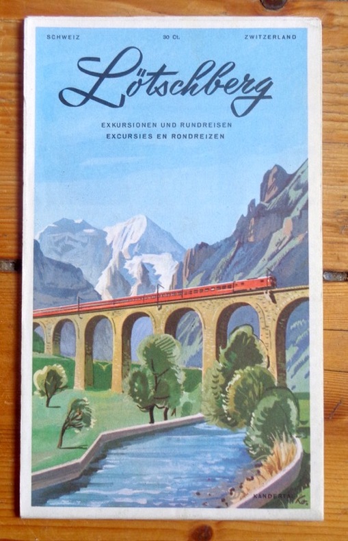
Lötschberg. Excursions et voyages circulaires. Excursions and circular tours - Exkursionen und Rundreisen - Excursies en rondreizen.
Carte dépliante en couleurs, publiée par les BLS (Berne-Loetschberg-Simplon). Photographies en noir et texte en 4 langues au verso. Divers itinéraires en train proposés.
Referencia librero : 2604
|
|
|
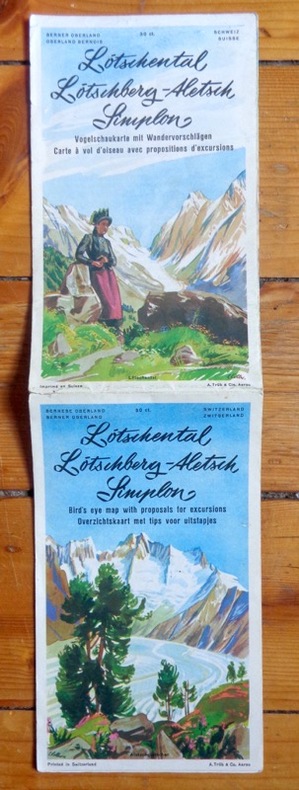
Lötschental, Lötschberg, Aletsch, Simplon. Carte à vol d'oiseau avec propositions d'excursions. Bird's eye map with proposals for excursions. Vogelschaukarte mit Wandervorschlägen. Overzichtskaart met tips voor uitstapjes.
Carte (vous l'aurez compris) dépliante en couleurs. Photographies en noir et texte en 4 langues au verso. Infimes déchirures.
Referencia librero : 2654
|
|
|
Madrid. Stadtplan im Maßstab 1: 35.500. Farbige Lithographie.
Leipzig, F. A. Brockhaus, [ca. 1905]. Bildgröße 21 x 14 cm. Unter Feinkartonpassepartout.
Referencia librero : 77013

|
|
|
Magdeburg-Altstadt und Werder. Stadtplan im Maßstab 1:14.700. Farblithographie.
Leipzig, F. A. Brockhaus, [ca. 1901. Bildgröße 20,5 x 14 cm. Unter Feinkartonpassepartout.
Referencia librero : 76499

|
|
|
Magdeburg. Stadtplan im Maßstab 1:32.000. Farbiger Holzstich.
Leipzig, F. A. Brockhaus, [ca. 1901. Bildgröße 20,5 x 13,5 cm. Unter Feinkartonpassepartout.
Referencia librero : 76500

|
|
|
Manchester and Salford City Centres Street Map with Index to Streets
Folded map in good condition, some creasing. No publication date. 50967. eng
|
|
|
Mansfeld: "Comitatus Mansfeldiae Descriptio.auctore Tilemanno Stella Sig". Altkolorierte Kupferstich-Karte von T. Stella bei Janssonius
37 x 43 cm. (Blatt: 42 x 55 cm). *Regionalkarte des Mansfeldischen Gebiets, gedruckt bei Janssonius, schönes Kolorit. - Sauber und sehr gut erhalten. Landkarten de
|
|
|
Mansfeld: "Mansfeldiae Comitatus Descriptio, auctore Tilemanno Stella Sig". Altkolorierte Kupferstich-Karte von T. Stella bei Abraham Ortelius
37 x 43 cm. (Blatt: 42 x 55 cm). *Regionalkarte des Mansfeldischen Gebiets, gedruckt bei Ortelius, schönes Flächenkolorit. - Sauber und sehr gut erhalten. Landkarten de
|
|
|
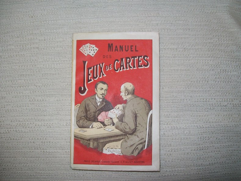
MANUEL des jeux de cartes.
Paris Delarue sd v 1900. In-16 broché couverture illustrée 176pp. Bel exemplaire.
Referencia librero : GITb923
|
|
|
Map of California and Nevada (1878).
Size: 60 x 49 cm (23 x 16 inch) with wide margins. Leaf: 69 x 51 cm (27 x 20 inch). Printed in red and green colour on thin paper. *Probably the 1878 edition. - "In 1858 William H. Rand, a native of Boston, established a printing office in Chicago and employed as a printer Andrew McNally. By 1868 Rand and McNally formed a partnership which soon acquired a reputation for printing railroad publications. In 1871 they introduced the Rand, McNally Railway Guide. That same year their business was destroyed in the Great Chicago Fire. Rand and McNally opened their new map department in late 1872. In January 1873 it was announced that "the house of Rand, McNally & Co. beg leave to inform their railroad friends and the patrons of the Railway Guide generally, that they have lately made extensive additions to their engraving department, and are now prepared to execute maps using relief-plate engraving [i.e., wax engraving] in the very highest style of the art." With the adoption of the wax engraving process, followed in May 1873 by the employment of a color printing process, the company`s reputation as one of the world`s leading commercial mapmakers was established. A major accomplishment of Rand, McNally was the publication in 1876 of the "New Railroad and County Map of the United States and Canada. Compiled from Latest Government Surveys, and Drawn to an Accurate Scale." That same year, the company used the plates from this map to produce its famous Commercial Atlas and Marketing Guide. This relief map of California and Nevada was included in Rand, McNally & Co.’s Business Atlas published in 1878-9. It shows cities, towns, waterways, and labeled railroad routes" (Historical maps). - Very good condition. Landkarten de
|
|
|
MAP OF ENVIRONS OF MANSFIELD
Nottingham: Roberts & Co. 1900. Not dated but c. 1900. Approximately 37 x 47cm folding down into printed paper covers. Map printed in black red and green. Generally very good a few short splits at folds of creases. A rare locally published map. Very Good. Roberts & Co. unknown
Referencia librero : 029479

|
|
|
Map of the Catholic churches of London: with double index.
London, Catholic Truth Society, [ca 1940]. rev. Ed. 1 map ; 77 x 51 cm., folded and fastened in covers 13 x 18 cm.
Referencia librero : ED3-992

|
|
|
MAPA-GUÍA DE LA NATURALEZA ESPAÑOLA - Madrid 1990 - Muy ilustrado
Madrid, Edit. Incafo, 1990. Numerosas ilustraciones en color. Numerosos mapas en color. 187 p. Folio. Rústica editorial ilustrada. Lomo en espiral. Muy buen ejemplar.
|
|
|
MAPPEMONDE AVEC L'INDICATION DE LA PARTIE DU GLOBE CONNU DES ANCIENS 1822
CARTE COULEUR GÉOGRAPHIQUE COULEUR format 44 cm x 33,5cm ( pliable en 4 parties) Imprimerie de Selves fils, lithographe de l'Université, rue des Lions St Paul n°14 Bel état, document authentique , couleur envoi Export suivis pour l'étranger ( 6,75 €)
Referencia librero : CZC-1431

|
|
 Recibir por correo electrónico
 Descargar en documento PDF
 Flujo RSS


