|
"Carte départementale de l'Ain.Extraite de l'atlas ""Levasseur"""
P. Levasseur, Sans date (vers 1850). In folio oblong (52/36cm).
Bookseller reference : 29157
|
|
|
"Carte départementale de la Saône et Loire.Extraite de l'atlas ""Levasseur"""
P. Levasseur, Sans date (vers 1850). In folio oblong (52/36cm).
Bookseller reference : 29257
|
|
|
"Carte départementale du Rhône.Extraite de l'atlas ""Levasseur"""
P. Levasseur, Sans date (vers 1850). In folio (52/36cm).
Bookseller reference : 29357
|
|
|
"Carte pour l`intelligence des combats qui ont eu lieu sur l`Elz et à Fribourg, au mois d` Octob. 1796". (Schlacht bei Emmendingen). Ausgearbeitet von Päringer (= Peringer)
Format: 26,5 x 40 cm. Blattgröße: 34,5 x 50 cm. *Detaillierte Karte im Maßstab 1 : 100.000 in früher Lithographie (Winkler, Inkunabel der Lithographie, Nr. 604). Blatt 38 aus einem Militäratlas. Zweimal gefaltet. Landkarten fr
|
|
|
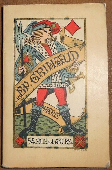
"Cartes à Jouer"
"Paris Éditions B. P. Grimaud s.d. (circa 1930) - Broché 6 5 cm x 10 5 cm 52 pages - Régles du piquet de la manille de l'écarté et de la belote - Très bon état"
Bookseller reference : 11175
|
|
|
"Charte des Königreichs Sachsen nach seiner neuesten durch den am 21. May zu Wien abgeschlossenen Friedens-Tractat definitiv bestimten Theilung zwischen Preussen und Sachsen". Grenzkolorierte Kupferstichkarte.
31 x 42 (bis zur Einfassungslinie beschnitten). Graphiken de
|
|
|
"Daenemark mit seinen Nebenländern in Europa". Grenzkolorierter Kupferstich, entworen und gezeichnet von C.F. Weiland. Mit 3 Inletkarten Island, FarÖer und Stadtplan Kopenhagen.
Format: 60 x 54 cm. Blattgröße: 70 x 56 cm. *Sauber und gut erhalten. Graphiken de
|
|
|
"Das Erzherzogthum Oesterreich ob- und unter der Enns". Karte von Ober- und Niederösterreich, mit Plan von Wien und Umgebung. Grenzkolorierter Kupferstich, entworfen und gez. von C.F. Weiland. Datiert
Format: 45,5 x 62 cm. Blattgröße: 56 x 72 cm. Mit Detailkarte von Wien - Linker Außenrand mit kleinem hinterlegtem Einriß, sauber und gut erhalten. Landkarten de
|
|
|
"Das europäische Russland". Grenzkolorierter Kupferstich, entworfen und gezeichnet von C.F. Weiland, berichtigt von H. Kiepert.
Format: 57 x 46 cm. Blattgröße: 70 x 56 cm. *Sauber und gut erhalten. Graphiken de
|
|
|
"Das nordwestliche Africa, enthaltend die Staaten Fez und Marokko, Algier, Tunis und Tripoli". Grenzkolorierter Kupferstich, entworfen und gezeichnet von C.F. Weiland, berichtigt von Kiepert.
Format: 42,5 x 64 cm. Blattgröße: 56 x 70 cm. *Sauber und gut erhalten. Landkarten de
|
|
|
"Die königl. Preussische Provinz Sachsen nebst den Herzogl. Anhaltischen Laendern". Grenzkolorierter Kupferstich, entworfen und gez. von C.F. Weiland.
Format: 56 x 49 cm. Blattgröße: 57 x 72 cm. *Rechter Außenrand mit leichten Feuchtigkeitsrändern, sonst sauber und gut erhalten. Landkarten de
|
|
|
"Die Nilländer oder Ägypten, Nubien und Habesch". Grenzkolorierter Kupferstich, entworfen. von C.F. Weiland umgrarb. von H. Kiepert.
Format: 62 x 48,5 cm. Blattgröße: 72 x 56 cm. *Sauber und gut erhalten. Landkarten de
|
|
|
"Hamburgum". REPRINT des Kupfers nach einer Zeichnung von Franz Hogenberg 1589.
[Braunschweig, Archiv-Verlag, 1987). 1 mehrfach gefalt. farb Plan (Blattgröße 41 x 53,5 cm, Bildgröße 37,5 cx 47,5 cm).
Bookseller reference : 99389
|
|
|
"Le Cercle de Souabe". Altkolorierte Kupferstichkarte nach Sanson bei Jaillot
57,5 x 88 cm (von 2 Platten gedruckt und mittig zusammengesetzt). *Erste Ausgabe. Großformatige Karte mit 2 kolorierten Kartuschen. Zeigt das Gebiet vom Bodensee und der Nordschweiz bis zur Höhe von Heidelberg und vom Elsaß im Westen bis nach Regensburg im Osten. - Aufgeklebt auf eine Preßspanplatte, Ränder knapp bechnitten und mit Randläsuren. Am Mittelfalz mit Bereibungen und unten mit kleineren Fehlstellen. Landkarten de
|
|
|
"Nieder-Guinea und das Innere des westlichen Mittel-Africa". Grenzkolorierter Kupferstich, entworfen und gezeichnet von C.F. Weiland, berichtigt von Kiepert 1849.
Format: 61 x 48,5 cm. Blattgröße: 70 x 56 cm. *Rechter Außenrand mit leicht gebräunten Feuchtigkeitsrändern, sonst sauber und gut erhalten. Landkarten de
|
|
|
"Nova Picardiae Tabula". Grenzkolorierte Kupferstichkarte französischen Provinz Picardie im nordöstlichen Frankreich. Grenzkolorierte Kupferstichkarte von Janssonius.
38,8 x 54,4 cm. (15 x 21 inch). *Detailed map of the northern part of France, including the area east of Calais till the Ardennes. - Rechter Unterrand etwas fleckig, sonst sauber und gut erhalten. Landkarten fr
|
|
|
"Oestliches Hoch-Africa mit Madagaskar und dem Aethiopischen Archipel". Grenzkolorierter Kupferstich, entworfen und gezeichnet von C.F. Weiland, berichtigt von Kiepert 1849.
Format: 60 x 51 cm. Blattgröße: 70 x 56 cm. *Sauber und gut erhalten. Landkarten de
|
|
|
"Principatus Anhaltinus". Altkolorierte Kupferstich-Karte des Fürstentums Anhalt bei Blaeu
39 x 52,5 cm. Mit breiten Rändern (Blatt: 55 x 64 cm). *Mit zwei ausgemalten figürlichen Kartuschen. Zeigt das Gebiet um Magdeburg, Wittenberg, Mansfeld, Halberstadt. - Sauber und sehr gut erhalten in schönem Altkolorit. Landkarten de
|
|
|
"Territorium Metense Auctore Ab. Fabert Consule urbis Metensis. Le Pais Messin". Kupferstich-Karte von W. Blaeu.
Format (Bildbereich): 39 x 50 cm. Gerahmt. *Landkarte. Zeigt den Lauf der Mosel zwischen Pont-a-Mousson und Thionville mit Metz im Zentrum. - Schönes Exemplar in gutem Altkolorit. - Sauber und sehr gut erhalten. Graphiken de
|
|
|
"Ungarn mit seinen Nebenländern und Galizien". Grenzkolorierter Kupferstich, gez. von H. Kiepert nach der Karte con Schedius, gestochen von Eulenstein.
Format: 51 x 63 cm. Blattgröße: 57 x 70 cm. *Sauber und gut erhalten. Graphiken de
|
|
|
1820. Carte Ora Maritima et interna Lybyae regio una cum Oasibus et Aegypto
Carte Ora Maritima et interna Lybyae regio una cum Oasibus et Aegypto accedit peculiatis Oasium ac praesertim Ammonii delineatio authentique datée vers 1820, recto uniquement, pliable, dimensions : 40x24cm, petite déchirure, bel état. Classeur 3
Bookseller reference : CZC-11675

|
|
|
1820. Carte Ora Maritima et interna Lybyae regio una cum Oasibus et Aegypto
Carte Ora Maritima et interna Lybyae regio una cum Oasibus et Aegypto accedit peculiatis Oasium ac praesertim Ammonii delineatio authentique datée vers 1820, recto uniquement, pliable, dimensions : 40x24cm, petite déchirure, bel état. Classeur 3
Bookseller reference : CZC-11675
|
|
|
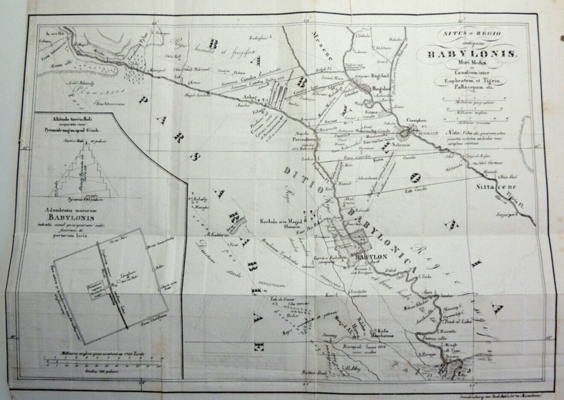
1820. Cartesitus et régio antiquae Babylonis, Muri Medici et Canalium, Euphratem
Cartesitus et régio antiquae Babylonis, Muri Medici et Canalium inter Euphratem et Tigrin, Pallocopam, etc authentique datée vers 1820, recto uniquement, pliable, dimensions : 34x28, petite déchirure, bel état. Classeur 3
Bookseller reference : CZC-11674
|
|
|
1985, catalogue des timbres de France Andorre-Europa
éditions La bourse du timbre 1985 1985, éditions La bourse du timbre, in-12 broché de 224 pages, nombreuses reproductions noir et blanc de timbres. Au sommaire : France, Andorre, C.F.A., Europa, compositions thématiques, fournitures et matériels philatélique. | Etat : Bon état général (Ref.: J5586)
Bookseller reference : 11391
|
|
|
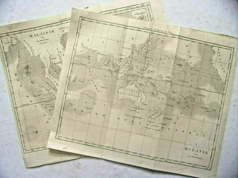
2 cartes géographiques de Th. Duvotenay. Malaisie & Océanie. 1810
2 cartes géographiques de Th. Duvotenay. Malaisie & Océanie. Très bon état, format 25x21m, pas de texte au dos, pliées en trois parties, imprimées vers 1810 ref/10
Bookseller reference : CZC-9247
|
|
|
2 cartes géographiques de Th. Duvotenay. Malaisie & Océanie. 1810
2 cartes géographiques de Th. Duvotenay. Malaisie & Océanie. Très bon état, format 25x21m, pas de texte au dos, pliées en trois parties, imprimées vers 1810 ref/10
Bookseller reference : CZC-9247
|
|
|
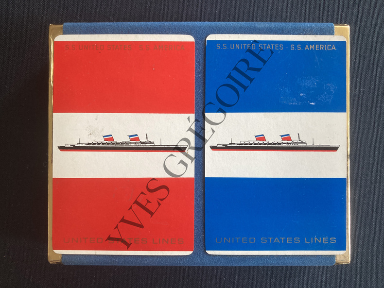
2 JEUX DE CARTES-SS UNITED STATES-SS AMERICA
2 JEUX DE CARTES DANS LEUR EMBALLAGE D'ORIGINE-BOITE D'ORIGINE VELOURS BLEU-(3B)
Bookseller reference : ABE-1653333027939
|
|
|
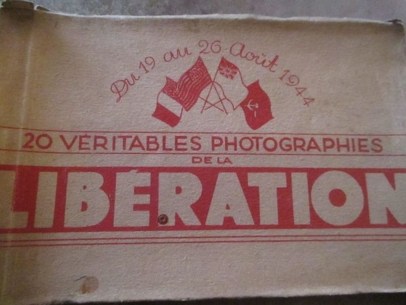
20 véritables photographies de la libération du 19 au 26 aout 1944
carnet de 20 cartes postales photographiques diffusées par photo presse libération
Bookseller reference : 5767
|
|
|
20jähriger Comptoir-Kalender mit Datum, Tag- und Monatszeiger, u. einer geograph. Uhrenscheibe. [Werbemittel].
[Hamburg], C. Adler, 1866. Kreisrunder Reklameausschnitt (Durchmesser: 9,5 cm) Lithographie unter rund ausgeschnitt. Schrägschnitt-Passepartout.
Bookseller reference : 81188

|
|
|
22 photos noir et blanc - Sabordage de la flotte à Toulon
(Ref.: Ref98933)
Bookseller reference : 9782845235882
|
|
|
24 Miles round London.
London, G. F. Cruchley, 1839. ca. 71 x 70 cm große Karte in 28 Segmenten, Decke mit aufkaschiertem marmoriertem Papier. Zustand 2, Ränder etwas bestoßen, Leinen einige nicht durchschlagende Flecken, dekorativer kartenrand wenige Fleckchen, aufkaschierte Verlagsanzeige auf Rückseite eines Segmentes.
Bookseller reference : 4673
|
|
|
250 fine and interesting old books in many fields, maps and atlases. A selection from our stock arranged in chronological order. (Nico Israel - Rare Books, Catalogue 25, Spring: 1989).
Amsterdam: Nico Israel 1989. 200 Seiten. Mit zahlreichen Abbildungen + Preisliste. Gr. 8° (22,5-25 cm). Orig.-Leinenband. [Hardcover / fest gebunden].
Bookseller reference : 99873

|
|
|
26 CARTES POSTALES-SCENES PARISIENNES
REPRODUCTIONS DE CARTES POSTALES ANCIENNES-N°14-81-82-84-88-89-91-92-93-94-95-99-100-101-106-112-113-114-116-119-120-122-124-125-127-137-(BCP10)
Bookseller reference : ABE-1560546614139

|
|
|
4 cartes entoilées avec emboîtage. Asie, Empire Romain IVe siècle, Royaume Barbares..
Carte de l'Europe indiquant les positions des royaumes barbares au 5e siècle - Carte de l'Asie - Carte de l'Empire Romain depuis Constantin jusqu’à la fin du 4e siècle - Carte de l'Allemagne et des contrées. Très bon état, format 50x40cm, imprimé vers 1810/20. ref/10
Bookseller reference : CZC-9246
|
|
|
8 cartes postales d'exécutions par pendaison à Trebinje, 1914
Très bel état. Sur une des photos on voit un pope prier, très nombreuses potences avec soldats et civils.
|
|
|
8 cartes postales deux volets Tintin - Noël, Hiver - Avec enveloppes
Hergé Moulinsart. | Etat : Neuf (Ref.: Ref98929)
Bookseller reference : 9782845235813
|
|
|
800 Jahre Hafen - Hamburg. Europa - Eine Chance für Hamburg. Hrsg. von SPD Kreis I, Hamburg Mitte.
(Hamburg, 1989). Mehrfach gefalt. farbiger Hafenplan (o. Maßstabangabe.). Blattgröße 49,5 x 69 cm, verso Anschluß Hafenplan (32 x 45 cm), Plan der Innenstadt, Übersichtskarte Hamburg u. Umgebung sowie Schnellbahnnetz. Mit 35 TextS., darin einige Abb. Deckelmaß 18 cm. OBrosch.
Bookseller reference : 52876

|
|
|
[Aargau]. Carte von dem Canton. Aargau eingetheilt in 11 Bezirke und 50 Kreise.
, , 1840. 1 carte coloriée, entoilée et repliée de 45 x 53 cm.
Bookseller reference : 4692
|
|
|
[Arcis-sur-Aube]. Carte d'Etat-Major n°67.
Paris, Au Dépôt de la Guerre, 1835. 1 carte entoilée et repliée de 57 x 85 cm.
Bookseller reference : 4780
|
|
|
[Bade (environs de)]. Situations-Charte der Gegend von Baden und dem Murgthale.
Carlsruhe & Baden, Marx, 1840 ca. 1 carte entoilée et repliée de 49 x 62 cm., sous étui et chemise cartonnés de l'époque, pièce de titre.
Bookseller reference : 4719
|
|
|
[Baden-Baden et es environs.]
, , 1881. 1 carte coloriée, entoilée et repliée de 38 x 43 cm., sous cartonnage brun de l'époque.
Bookseller reference : 4694
|
|
|
[Blois].
A Paris, Jean Goujon, 1815. 1 carte entoilée et repliée de 58 x 89 cm. Étiquette ancienne de l'éditeur.
Bookseller reference : 5255
|
|
|
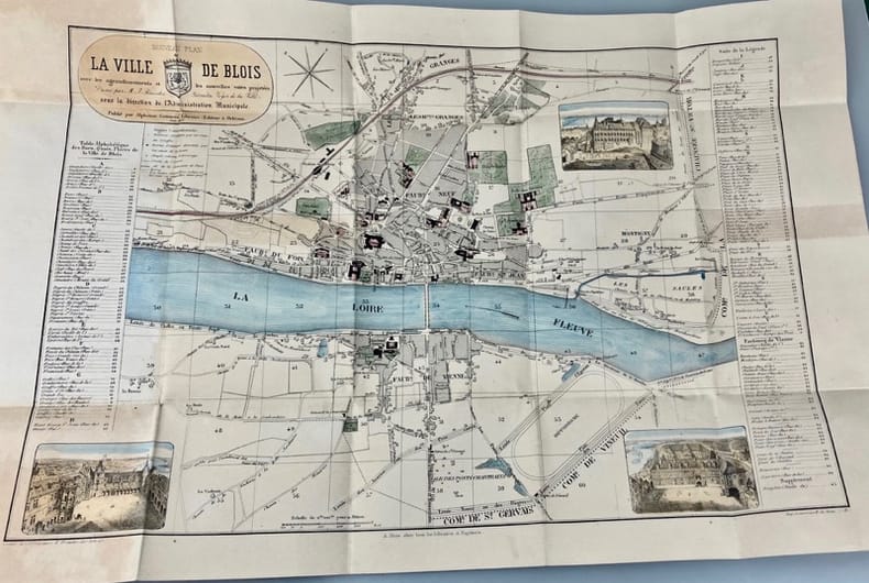
[Blois]. Nouveau plan de la ville de Blois avec les agrandissements et les nouvelles voies projetées dressé par M. J. Bressler géomètre voyer de la ville sous la direction de l'Administration Municipale.
Orléans, Alphonse Gatineau, 1837. 1 carte coloriée et repliée de 35 x 53,5 cm., sous cartonnage de l'éditeur.
Bookseller reference : 4697
|
|
|
[Châteauroux]. Plan de la ville de Châteauroux.
A Châteauroux, Salviac, 1851. 1 carte entoilée et repliée de 52,5 x 60,5 cm., sous étui cartonné de l’époque.
Bookseller reference : 4763
|
|
|
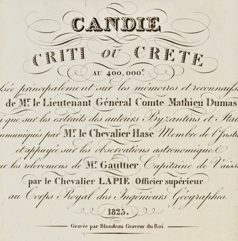
[Crète ottomane. 1825]. Candie Criti ou Crète au 400.000. Dressée principalement sur les mémoires et reconnaissances de Mr le lieutenant général comte Mathieu Dumas ainsi que sur les extraits des auteurs Byzantins et italiens communiqués par Mr. le chevalier Hase, membre de l’Institut, et appuyée sur les observations astronomiques et sur les relèvements de Mr. Gauttier, capitaine de vaisseau par le chevalier Lapie, officier supérieur au corps royal des ingénieurs géographes.
Paris, Picquet, 1825. Plan replié et entoilé de 78 x 50 cm, étiquette "J. Goujon marchand de cartes rue du Bac n°6 à Paris".
Bookseller reference : 41623
|
|
|
[Gien]. Carte d'état major n°109.
Paris, Au Dépôt de la Guerre , 1845. 1 carte entoilée et repliée de 57 x 85 cm.
Bookseller reference : 4757
|
|
|
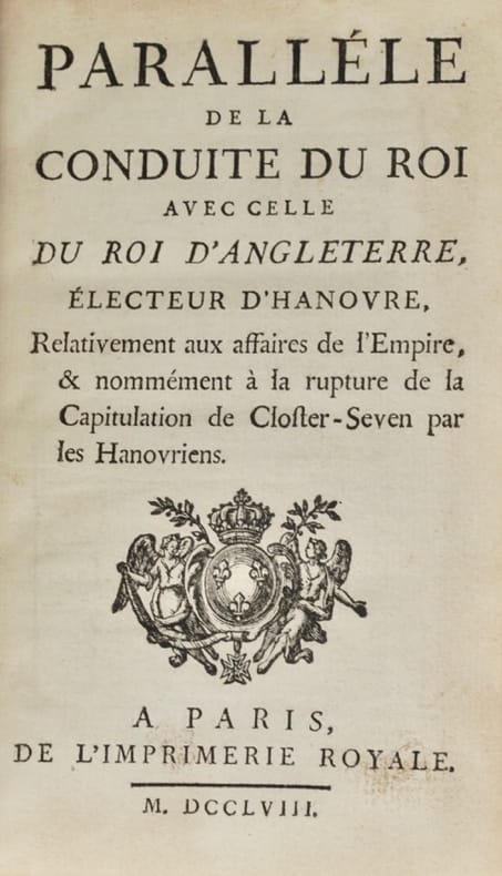
[Guerre de Sept ans. Jersey et Guernesey]. Paralléle de la conduite du Roi avec celle du roi d'Angleterre, électeur d'Hanovre, relativement aux affaires de l'Empire, & nommément à la rupture de la capitulation de Closter-Seven par les Hanovriens.
Paris, Imprimerie royale, 1758. In-12 de XLVIII-138 pp. [FALLE (Philip) ; LE ROUGE (Georges-Louis)]. Histoire détaillée des Isles de Jersey et Guernesey, traduite de l'anglois. Paris, Veuve Delaguette, Duchesne, 1757. In-12 de (2)-IV-(2)-181-(3) pp., 2 cartes repliées2 pièces reliées en 1 vol. in-12, veau granité dos orné à nerfs, pièce de titre en maroquin rouge, tranches rouges, table manuscrite à l'encre du temps sur la garde supérieure (reliure de l'époque).
Bookseller reference : 42093
|
|
|
[Hambourg]. Hamburg mit seinen nächsten Umgebungen.
, Zuv. Hess Topographie neue Ausgabe, 1810. 1 carte entoilé et replié de 37 x 50 cm., sous étui cartonné de l'éditeur.
Bookseller reference : 4731
|
|
 Receive by email
 Download as PDF document
 RSS feed
