|
Collins Maps
Short walks in the Lake District Collins Ramblers
2014-02-06. New. Ships with Tracking Number! INTERNATIONAL WORLDWIDE Shipping available. May be re-issue. Buy with confidence excellent customer service! unknown
Bookseller reference : 0007555016n ISBN : 0007555016 9780007555017

|
|
|
Collins Maps
Short walks in the Yorkshire Dales
2014-07-05. New. Ships with Tracking Number! INTERNATIONAL WORLDWIDE Shipping available. May be re-issue. Buy with confidence excellent customer service! unknown
Bookseller reference : 0007555024n ISBN : 0007555024 9780007555024

|
|
|
Collins Maps
Short Walks In Dorset
2015-06-01. Good. Ships with Tracking Number! INTERNATIONAL WORLDWIDE Shipping available. May not contain Access Codes or Supplements. May be re-issue. May be ex-library. Shipping & Handling by region. Buy with confidence excellent customer service! unknown
Bookseller reference : 0008101566 ISBN : 0008101566 9780008101565

|
|
|
Collins Maps
Short Walks In Northumbria
2015-06-01. Good. Ships with Tracking Number! INTERNATIONAL WORLDWIDE Shipping available. May not contain Access Codes or Supplements. May be re-issue. May be ex-library. Shipping & Handling by region. Buy with confidence excellent customer service! unknown
Bookseller reference : 0008101582 ISBN : 0008101582 9780008101589

|
|
|
Collins Maps
Short walks in the Yorkshire Dales
2014-07-05. Good. Ships with Tracking Number! INTERNATIONAL WORLDWIDE Shipping available. May not contain Access Codes or Supplements. May be re-issue. May be ex-library. Shipping & Handling by region. Buy with confidence excellent customer service! unknown
Bookseller reference : 0007555024 ISBN : 0007555024 9780007555024

|
|
|
Collins Maps
Short Walks In The North York Moors
2015-09-09. Good. Ships with Tracking Number! INTERNATIONAL WORLDWIDE Shipping available. May not contain Access Codes or Supplements. May be re-issue. May be ex-library. Shipping & Handling by region. Buy with confidence excellent customer service! unknown
Bookseller reference : 0008101574 ISBN : 0008101574 9780008101572

|
|
|
Collins Maps
Short Walks In The North York Moors
HarperCollins UK. Used - Good. Ships from the UK. Former Library book. Shows some signs of wear and may have some markings on the inside. 100% Money Back Guarantee. Your purchase also supports literacy charities. HarperCollins UK unknown
Bookseller reference : GRP87600758 ISBN : 0008101574 9780008101572

|
|
|
Collins Maps
Short Walks in Cornwall
Paperback. As New. A practical little walk guide to Cornwall endorsed by the Ramblers. All of the 20 walks are 5 miles or under in length and can easily be completed in less than 3 hours. Clear Ordnance Survey maps show the route along with easy-to-follow walk descriptions. Cornwall forms the tip of the south-west pe paperback
Bookseller reference : ria9780008101558_rkm ISBN : 0008101558 9780008101558

|
|
|
Collins Maps
Short Walks in Dorset
Paperback. As New. A practical little walk guide to Dorset endorsed by the Ramblers. All of the 20 walks are 5 miles or under in length and can easily be completed in less than 3 hours. Clear Ordnance Survey maps show the route along with easy-to-follow walk descriptions. The southern English county of Dorset contain paperback
Bookseller reference : ria9780008101565_rkm ISBN : 0008101566 9780008101565

|
|
|
Collins Maps
Skye Pocket Map: The perfect way to explore Skye Maps
Collins 2018. Map. New. 5.51x3.54x0.31 inches. Collins unknown
Bookseller reference : __0008285640 ISBN : 0008285640 9780008285647

|
|
|
Collins Maps
Skye Pocket Map: The Perfect Way to Explore Skye
2018-06-01. Good. Ships with Tracking Number! INTERNATIONAL WORLDWIDE Shipping available. May not contain Access Codes or Supplements. May be re-issue. May be ex-library. Shipping & Handling by region. Buy with confidence excellent customer service! unknown
Bookseller reference : 0008285640 ISBN : 0008285640 9780008285647
|
|
|
Collins Maps
Stars and Planets
2013-08-01. New. Ships with Tracking Number! INTERNATIONAL WORLDWIDE Shipping available. May be re-issue. Buy with confidence excellent customer service! unknown
Bookseller reference : 0007532261n ISBN : 0007532261 9780007532261

|
|
|
Collins Maps
Stars and Planets
2013-08-01. Good. Ships with Tracking Number! INTERNATIONAL WORLDWIDE Shipping available. May not contain Access Codes or Supplements. May be re-issue. May be ex-library. Shipping & Handling by region. Buy with confidence excellent customer service! unknown
Bookseller reference : 0007532261 ISBN : 0007532261 9780007532261

|
|
|
Collins Maps
Tartans Map of Scotland Collins Pictorial Maps
2012-05-08. New. Ships with Tracking Number! INTERNATIONAL WORLDWIDE Shipping available. May be re-issue. Buy with confidence excellent customer service! unknown
Bookseller reference : 0007485883n ISBN : 0007485883 9780007485888

|
|
|
Collins Maps
Tartans Map of Scotland Collins Maps
Collins 02/06/2020. New edition. Map. Used; Good. WE SHIP WITHIN 24 HRS FROM LONDON UK 98% OF OUR ORDERS ARE RECEIVED WITHIN 7-10 DAYS. We believe you will be completely satisfied with our quick and reliable service. All orders are dispatched as swiftly as possible! Buy with confidence! Collins unknown
Bookseller reference : 3764547 ISBN : 0008368295 9780008368296

|
|
|
Collins Maps
Tartans Map Of Scotland
Harpercollins Publishers 2020. Sheet Map Folded. New. new ed edition. 1 pages. Harpercollins Publishers unknown
Bookseller reference : __0008368295 ISBN : 0008368295 9780008368296
|
|
|
Collins Maps
Wales Pocket Map: The perfect way to explore Wales
Sheet map folded. New. Handy little full colour map of the whole of Wales. Excellent value and very detailed for its size. unknown
Bookseller reference : A9780008328078 ISBN : 0008328072 9780008328078

|
|
|
Collins Maps
Wales Pocket Map
Harpercollins Publishers 2019. Sheet Map Flat. New. new ed edition. Harpercollins Publishers unknown
Bookseller reference : __0008328072 ISBN : 0008328072 9780008328078

|
|
|
Collins Maps
Wales Pocket Map : The Perfect Way to Explore Wales
Paperback. New. Handy little full colour map of the whole of Wales. Excellent value and very detailed for its size. Key features of this map include: Clear mapping at a scale of 3.9 miles to 1 inch Tourist attractions located Includes National parks and long distance paths Ideal companion to a sat-nav - it paperback
Bookseller reference : ria9780008328078_new ISBN : 0008328072 9780008328078
|
|
|
Collins Maps
Wales Pocket Map
2019-02-07. New. Ships with Tracking Number! INTERNATIONAL WORLDWIDE Shipping available. May be re-issue. Buy with confidence excellent customer service! unknown
Bookseller reference : 0008328072n ISBN : 0008328072 9780008328078

|
|
|
Collins Maps
Wales Pocket Map : The Perfect Way to Explore Wales
Paperback. As New. Handy little full colour map of the whole of Wales. Excellent value and very detailed for its size. Key features of this map include: Clear mapping at a scale of 3.9 miles to 1 inch Tourist attractions located Includes National parks and long distance paths Ideal companion to a sat-nav - it paperback
Bookseller reference : ria9780008328078_rkm ISBN : 0008328072 9780008328078
|
|
|
Collins Maps
Whisky Map of Scotland Collins Pictorial Maps
Collins 2017-02-09. Map. Used:Good. Collins unknown
Bookseller reference : DADAX0008225079 ISBN : 0008225079 9780008225070

|
|
|
Collins Maps
Whisky Map of Scotland Collins Pictorial Maps
Sheet map folded. New. Discover where Scotland's national drink is produced. All of Scotland's operational whisky distilleries and whisky-related places of interest located on one map. Also includes an easy-to-use index listing visitor facilities contact details and websites. unknown
Bookseller reference : A9780008225070 ISBN : 0008225079 9780008225070

|
|
|
Collins Maps
Whisky Map of Scotland Collins Pictorial Maps
2017-02-09. New. Ships with Tracking Number! INTERNATIONAL WORLDWIDE Shipping available. May be re-issue. Buy with confidence excellent customer service! unknown
Bookseller reference : 0008225079n ISBN : 0008225079 9780008225070

|
|
|
Collins Maps
Wild Atlantic Way Pocket Map: The perfect way to explore Ireland's west coast
Sheet map folded. New. Handy little full colour map of Ireland's Wild Atlantic Way with a high level of detail. Clear mapping of the full 2500 km over 1500 miles showing the road network and places of interest. Ideal for tourists locals hikers and adventurers. Excellent value and very detailed for its size. unknown
Bookseller reference : A9780008320409 ISBN : 0008320403 9780008320409

|
|
|
Collins Maps
Wild Atlantic Way Pocket Map: The Perfect Way To Explore Ireland's West Coast
Harpercollins Publishers 2019. Sheet Map Folded. New. Harpercollins Publishers unknown
Bookseller reference : __0008320403 ISBN : 0008320403 9780008320409

|
|
|
Collins Maps
Wild Atlantic Way Pocket Map : The Perfect Way to Explore Ireland's West Coast
Paperback. New. Handy full colour map of Ireland's Wild Atlantic Way with a high level of detail. Clear mapping of the full 2500 km over 1500 miles showing the road network and places of interest. Ideal for tourists locals hikers and adventurers. Places of interest marked including famous film locations. Excel paperback
Bookseller reference : ria9780008320409_new ISBN : 0008320403 9780008320409
|
|
|
Collins Maps
Wild Atlantic Way Pocket Map : The Perfect Way to Explore Ireland's West Coast
Paperback. As New. Handy full colour map of Ireland's Wild Atlantic Way with a high level of detail. Clear mapping of the full 2500 km over 1500 miles showing the road network and places of interest. Ideal for tourists locals hikers and adventurers. Places of interest marked including famous film locations. Excel paperback
Bookseller reference : ria9780008320409_rkm ISBN : 0008320403 9780008320409
|
|
|
Collins Maps
World Atlas Collins Student Atlas
Collins. New Fourth edition. Hardcover. Used; Good. Simply Brit Shipped with Premium postal service within 24 hours from the UK with impressive delivery time. We have dispatched from our book depository; items of good condition to over ten million satisfied customers worldwide. We are committed to providing you with reliable and efficient service at all times. 02/02/2012 Collins hardcover
Bookseller reference : 2738120 ISBN : 000743782x 9780007437825

|
|
|
Collins Maps
World Atlas: Reference Edition Collins
Collins 11/08/2012. Reference edition. Hardcover. Used; Good. WE SHIP WITHIN 24 HRS FROM LONDON UK 98% OF OUR ORDERS ARE RECEIVED WITHIN 7-10 DAYS. We believe you will be completely satisfied with our quick and reliable service. All orders are dispatched as swiftly as possible! Buy with confidence! Collins hardcover
Bookseller reference : 2034262 ISBN : 0007500378 9780007500376

|
|
|
Collins Maps
World Atlas Collins Student Atlas
Collins. New Fourth edition. Paperback. Used; Good. Simply Brit Shipped with Premium postal service within 24 hours from the UK with impressive delivery time. We have dispatched from our book depository; items of good condition to over ten million satisfied customers worldwide. We are committed to providing you with reliable and efficient service at all times. 02/02/2012 Collins paperback
Bookseller reference : 1470323 ISBN : 0007437811 9780007437818

|
|
|
Collins Maps
World Atlas Collins Student Atlas
Collins 02/02/2012. New Fourth edition. Paperback. Used; Good. WE SHIP WITHIN 24 HRS FROM LONDON UK 98% OF OUR ORDERS ARE RECEIVED WITHIN 7-10 DAYS. We believe you will be completely satisfied with our quick and reliable service. All orders are dispatched as swiftly as possible! Buy with confidence! Collins paperback
Bookseller reference : 2505344 ISBN : 0007437811 9780007437818
|
|
|
Collins Maps
World Atlas: Illustrated Edition
Collins 04/26/2012. Illustrated edition. Paperback. Used; Good. WE SHIP WITHIN 24 HRS FROM LONDON UK 98% OF OUR ORDERS ARE RECEIVED WITHIN 7-10 DAYS. We believe you will be completely satisfied with our quick and reliable service. All orders are dispatched as swiftly as possible! Buy with confidence! Collins paperback
Bookseller reference : 1761049 ISBN : 0007452659 9780007452651

|
|
|
Collins Maps
World Atlas: Essential Edition
Collins. Paperback. Used; Good. Simply Brit Shipped with Premium postal service within 24 hours from the UK with impressive delivery time. We have dispatched from our book depository; items of good condition to over ten million satisfied customers worldwide. We are committed to providing you with reliable and efficient service at all times. 03/03/2011 Collins paperback
Bookseller reference : 1209221 ISBN : 0007419767 9780007419760

|
|
|
Collins Maps
World Atlas: Paperback Edition
Collins. Paperback. Used; Good. Simply Brit Shipped with Premium postal service within 24 hours from the UK with impressive delivery time. We have dispatched from our book depository; items of good condition to over ten million satisfied customers worldwide. We are committed to providing you with reliable and efficient service at all times. 02/03/2011 Collins paperback
Bookseller reference : 1255714 ISBN : 0007419759 9780007419753

|
|
|
Collins Maps
World Atlas Collins Junior Atlas
Collins 02/03/2011. New Second edition. Paperback. Used; Good. WE SHIP WITHIN 24 HRS FROM LONDON UK 98% OF OUR ORDERS ARE RECEIVED WITHIN 7-10 DAYS. We believe you will be completely satisfied with our quick and reliable service. All orders are dispatched as swiftly as possible! Buy with confidence! Collins paperback
Bookseller reference : 1801181 ISBN : 0007393571 9780007393572

|
|
|
Collins Maps
World Atlas: Reference Edition Collins
Collins. Second edition. Hardcover. Used; Good. Simply Brit Shipped with Premium postal service within 24 hours from the UK with impressive delivery time. We have dispatched from our book depository; items of good condition to over ten million satisfied customers worldwide. We are committed to providing you with reliable and efficient service at all times. 11/08/2012 Collins hardcover
Bookseller reference : 1968608 ISBN : 0007500378 9780007500376
|
|
|
Collins Maps
Xworld Atlas Reference Edit Hb
Harpercollins 09/08/2016. Hardcover. Used; Good. WE SHIP WITHIN 24 HRS FROM LONDON UK 98% OF OUR ORDERS ARE RECEIVED WITHIN 7-10 DAYS. We believe you will be completely satisfied with our quick and reliable service. All orders are dispatched as swiftly as possible! Buy with confidence! Harpercollins hardcover
Bookseller reference : 3670062 ISBN : 0008209766 9780008209766
|
|
|
Collins UK Collins UK Collins UK Collins UK Collins UK Harpercollins Staff Collins Maps Staff
Children's World Atlas
Harper Collins Publishers 01-Apr-2014. hardcover. New. pp. 144 Harper Collins Publishers hardcover
Bookseller reference : 697237900 ISBN : 0007514263 9780007514267

|
|
|
COLMAR
Carte allemande au 1/80 000?. Fin XIXe.
1 feuille repli?e. 31,5x45 cm.
|
|
|
COLMAR
Carte d'Etat-Major au 1/200 000?. Fin XIXe.
1 feuille repli?e. 32x49 cm.
|
|
|
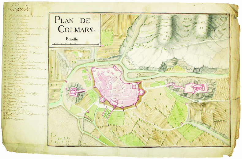
COLMARS. MANUSCRIT.
Plan de Colmars.
[circa 1750]. En deux feuilles jointes de 395 x 600 mm.
Bookseller reference : LBW-4174
|
|
|
Colonel Red Reeder; Maps by Ned Glattauer
The Northern Generals
Duel Sloan Pearce 1963-01-01. Hardcover. Good. B004309E3M EX-LIBRARY. This book is in good condition binding and pages show a small amount of wear. Dust Jacket is crisp and clean. Duel Sloan Pearce hardcover
Bookseller reference : SKU1038319
|
|
|
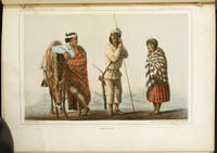
COLORADO RIVER EXPEDITION MAPS & VIEWS Ives Joseph C. etal. v. Egloffstein FW. and Heinrich Mollhausen illus. F. W.
Report Upon the Colorado River of the West Explored in 1857 and 1858 by Lieutenant Joseph C. Ives.
Washington D.C.: Government Printing Office. Senate Edition. 1861. Decorative cloth-covered boards 11 1/4 x 9 inches 7 color lithographic plates of Native American Indians 12 black and white engravings 2 folding maps No. 1 From mouth of Colorado to Head of Navigation No. 2 From Head of Navigation to Fort Defiance Profile From the Big Sandy to the Colorado north of the Needles 8 panoramic views. Report in five parts: General Report 131 pp; Hydrographic Report 14 pp; Geological Report 154 pp.; Botany 30 pp; Zoology 6 pp; Appendices. Triangular water stain on plates running from the free edge to page bottom; 5 1/2 inches along the diagonal. The volume is basically disbound with the front cover and first two dozen pages detached from rest of text block. Discoloration and tears to several of these pages; one very short tear to each map. Front cover and spine badly abraded. A pair of tinted geological maps called for not present in Part III. Sold with all faults. The damp stain to the plates is a conundrum as the text pages adjacent appear virtually undamaged. It is almost as if the plates were damaged prior to binding--admittedly an unlikely scenario. Equally strange the eight scenic panoramas and the frontispiece maps the work of F. W. v. Egloffstein are undamaged. Additional artwork by Heinrich Möllhausen. There are seven color lithographic plates of indigenous Native Americans: the Cocopa Yuma Moqui Navajo etc. The volume is physically in poor condition given the problems cited above. However it still has enormous power as a record of this expedition and the still amazing territory that it documents powerfully brought to life in the many illustrations and maps. . Government Printing Office. hardcover
Bookseller reference : 50715
|
|
|
Colson Jean and 57 b/w Engravings Document Maps
Paris: From Its Origins to the Present Day
Paperback. Fine. illus.Fine paperback. paperback
Bookseller reference : 9299 ISBN : 2903118922 9782903118921
|
|
|
Colson Jean and 57 b/w Engravings Document Maps
Paris: From Its Origins to the Present Day
Paperback. Fine. illus.Fine paperback. paperback
Bookseller reference : 5188 ISBN : 2903118922 9782903118921
|
|
|
COLTON (Joseph Hutchins).
[DANEMARK] Denmark.
New York, 1855. 402 x 327 mm.
Bookseller reference : LBW0394f
|
|
|
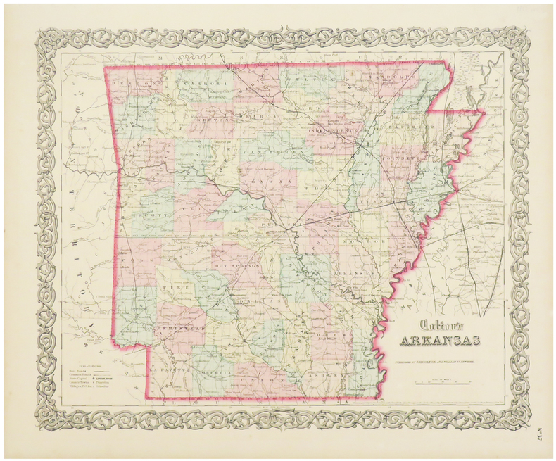
COLTON (Joseph Hutchins).
Arkansas.
New York, 1855. 402 x 327 mm.
Bookseller reference : LBW03588
|
|
|
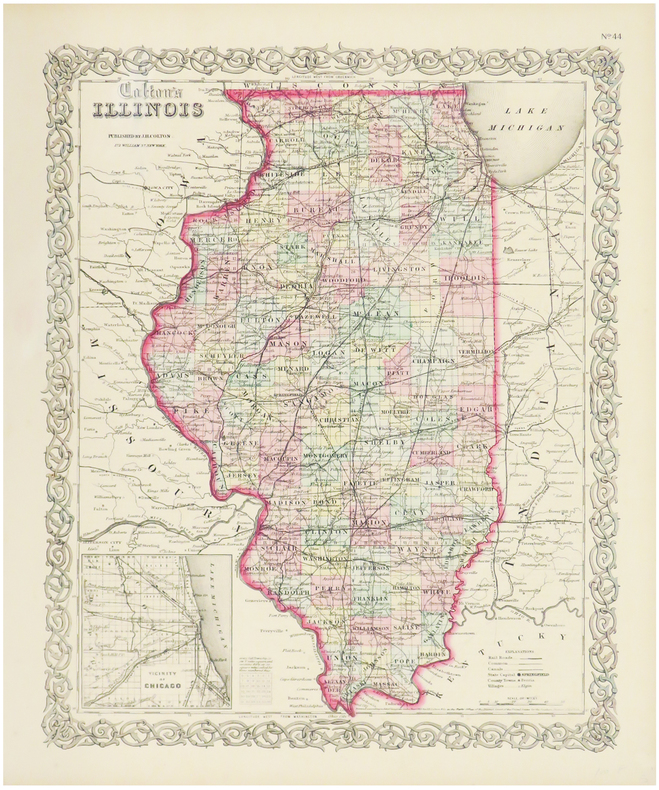
COLTON (Joseph Hutchins).
Illinois.
New York, 1855. 400 x 327 mm.
Bookseller reference : LBW0357e
|
|
|
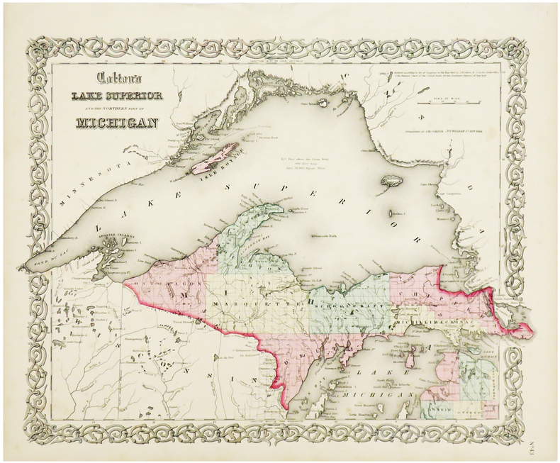
COLTON (Joseph Hutchins).
Lake Superior and the northern part of Michigan.
New York, 1855. 327 x 415 mm.
Bookseller reference : LBW0358a
|
|
 Receive by email
 Download as PDF document
 RSS feed


