|
|
|
|
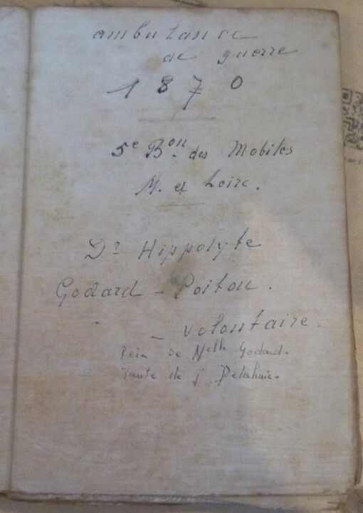
"Carte de France - Ambulance de guerre 1870"
"Londres Éditions G. W. Bacon & Cie s.d. (circa 1870) - Toilé en couleur 85 cm x 86 cm en 24 lés de 14 5 cm x 21 5 cm - Au dos il est écrit très lisiblement : ambulance de guerre 1870 - 5e Bon des Mobiles M. et Loire - Dr Hippolyte Godard-Poitou - volontaire - Père de Melle Godard Tante de J. Delahaie - Etat d'usage"
Referência livreiro : 14658
|
|
|
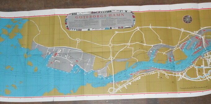
"Göteborg Hamn The Port of Gothenburg"
"1969. Göteborg (Suède) Handelstryckeriet 1969 - Carte en couleur au 1 :10000 45 5 cm x 140 cm- Texte en anglais et en suédois - Pliures usagées sinon bon état"
Referência livreiro : 16085
|
|
|
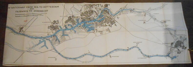
"New Waterway from Sea to Rotterdam and Fairways to Dordrecht"
"1957. Rotterdam(Pays-Bas) Publishers WYT 1957 - Carte en noir et bleu 39 cm x 144 cm- Texte en anglais - Bon état"
Referência livreiro : 16087
|
|
|
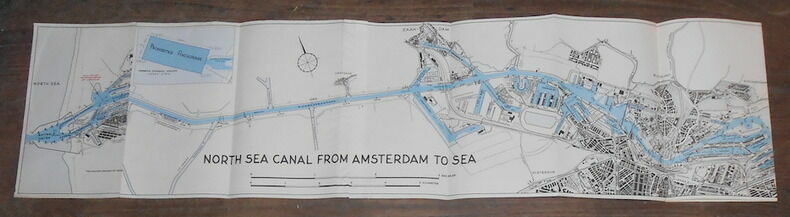
"North Sea Canal from Amsterdam to Sea"
"1957. Amsterdam (Pays-Bas) Publishers WYT 1957 - Carte en noir et bleu 22 cm x 130 cm- Texte en anglais - Bon état"
Referência livreiro : 16086
|
|
|
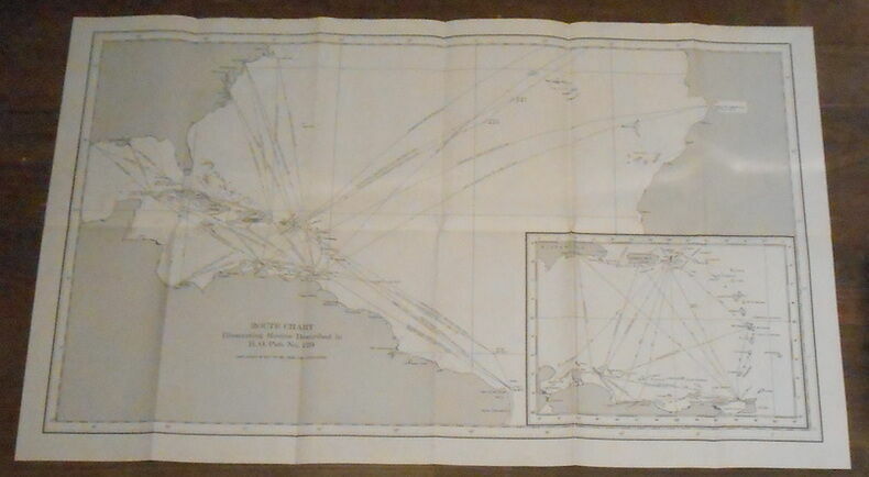
"Route Chart Illustrating Routes Described in H.O. Pub. No. 129"
"Sans lieu sans éditeur sans date (circa 1960) - Carte 47 cm x 78 cm- Texte en anglais - Carte des lignes maritimes au départ de Port of Spain (Trinidad et Tobago) et Willemstadt (Curaçao)- Très bon état"
Referência livreiro : 16089
|
|
|
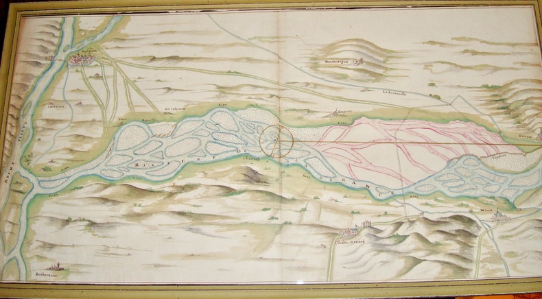
(Plan de la Durance , à sa jonction avec le Rhône.)
Intéressant plan qui nous montre des aménagements des rives de la Durance à son approche d’Avignon; on peut y localiser Avignon, Barbantane, Noves, Châteaurenard ainsi que la Courtine, Mondevergues etc XVIIIè siècle 40 x 74,5 cm avec le cadre.
Referência livreiro : 6450
|
|
|
1695 - 1995 CELEBRAZIONI DI GIACOMO CANTELLI NEL III CENTENARIO DELLA MORTE
CARPETTA CON MATERIALE DIVULGATIVO INERENTE ALLE CELEBRAZIONI "GIACOMO CANTELLI" GEOGRAFO DEL SERENISSIMO E SEGNALIBRO.
|
|
|
A CHART OF THE ADRIATIC SEA ,GULF OF VENICE, WITH THE IONIAN ISLANDS AND ADJACENT COAST; drawn from the Surveys made by order of the Austrian, English, and Neapolitan Governments,by J.S. Hobbs, Hydrographer.
Grande carta applicata su carta blu, dimensioni cm 68x188. pubblicata a Londra presso Charles Wilson nel 1882. Bella carta in cui sono descritte le varie località della costa che si affaccia sul Mare Adriatico e riquadri con dettagli su alcuni porti e baie ( Durazzo , Zante, Argostoli, Vostitza, Navarino, Venezia, Brindisi…….... lievi tracce del tempo nel complesso buono stato di conservazione

|
|
|
A LIST OF GEOGRAPHICAL ATLASES IN THE LIBRARY OF CONGRESS. Compiled by Philip Lee Phillips. Bd 1 - 4 in 2 Bdn. Reprint (der Ausgabe Washington 1901 - 1920).
Amsterdam, Theatrum Orbis Terrarum, 1971. 13, 1659 S. u. 1 Bl., 137, 1030; 163, 639 S. OLwdbd (Kanten u. Gelenke teils stärker bestoßen, erste u. letzte Blätter etwas knickfaltig).
Referência livreiro : 1247911
|
|
|
Africa
bella carta a colori stampata su carta pesante incisa da P. Allodi e Figlio, più volte ripiegata, misure cm. 95 x 65, sono comprese le varie isole incluse le Canarie. Con le possessioni e stabilimenti degli stati europei segnati a colori. Graziosa copertina figur.
|
|
|
AGRIMENSURA (Bussola - Ciclografo - Squadro a riflessione). Due tavole con incisioni in rame tratte dall'ATLANTE della NUOVA ENCICLOPEDIA POPOLARE ITALIANA.
(Codice OS/0257) Le 2 tavole (29,5x21,5 cm) impresse su carta forte, con 13 incisioni in rame, sono ORIGINALI, provengono da un volume sciolto. Ottimo stato. A garanzia dell'autenticità, alleghiamo fotocopie di: frontespizio, prefazione (10 pp.) e indice delle tavole con elenco delle incisioni. ~~~ SPEDIZIONE IN ITALIA SEMPRE TRACCIATA

|
|
|
Alexander Weltatlas. Gesamtausgabe.
Stuttgart, Klett, (1976). 4. M. zahlr. farb. Ktn. 194 S. OPp. Unt. Rücken gering bestoßen u. m. kl. Kleberest. Bind. a. Tit. fachmänn. stabilisiert.
Referência livreiro : 134422
|
|
|
ALTE KARTEN. Ein Leitfaden für Sammler und Liebhaber.
Berlin, Wertheim - Das Biblographikon, 1931. 71, (1) S. m. 13 Abb. im Text, 1 Tafel. Lwdbd m. eingebund. OBroschur (Rücken oben m. winz. Feuchtigkeitsspur, innen etwas gebräunt).
Referência livreiro : 1321227
|
|
|
America. Das frühe Bild d. Neuen Welt. Hrsg. v. H. Wolff.
(München), Prestel, (1992). 4°. M. zahlr. (teils farb./teils blattgr.) Abb. 192 S. OLwd.
Referência livreiro : 121523
|
|
|
Andrea Palladio. Il testo, l'immagine, la città. Bibliografia e iconografia palladiane, cartografia vicentina, Palladio accademico olimpico. Electa, 1980.
|
|
|
Annuario dell'Istituto Cartografico Italiano. Anno 3/4.
Roma, 1889. M. 1 gef. Taf. u. 1 gef. farb. Kte. IX, 138 S. OBr. Unaufgeschn. Ex. Umschlag angeschmutzt, m. Randläsuren bzw. kl. Fehlst. M. mehr. St. Vord. Umschlag u. Vorsatz wasserrandig.
Referência livreiro : 248731
|
|
|
Aquila - Popoli e Popoli - Pescara. Planimetrie e profili ciclistici n. 14 e 15
Cartina più volte ripiegata a fisarmonica; 22 x 136 cm. Ottima
|
|
|
Arbeiten aus d. geodätischen u. kartographischen Dienst. Bd. 4.
Leipzig, 1964. M. zahlr. Tab. u. Abb. 150 S. St. a. Tit.
Referência livreiro : 247800
|
|
|
Arcipelago verde. La prima guida completa per chi am la natura
16°, 18 cm, pp. 221, brossura editoriale illustrata, titolo al piatto e dorso, esemplare ottimo

|
|
|
Astronomisch-geodätische Arbeiten im Jahre 1878. Bestimmung d. Längendifferenzen Berlin-Altona-Helgoland, Altona-Bonn-Wilhelmshaven, Altona-Wilhelmshaven.
Berlin, 1879. 4°. 192 S. OBr. Rücken agnerissen. Umschl. angeschmutzt u. eingerissen. Hint. Umschl. fehlt. Letztes Bl. etwa stockfl. (Publ.. d. Königl. Preusz. Geodät. Inst.)
Referência livreiro : 162993
|
|
|
Astronomisch-geodätische Arbeiten im Jahre 1911. Bestimmung d. Längendifferenzen Gotha-Knüll, Knüll-Erndtebrück, Erndtebrück-Bonn u. Bonn-Düsseldorf u. d. Polhöhe auf d. Dreieckspunkte Erndtebrück.
Potsdam, 1912. 4°. IV, 78 S. OBr. Umschl. angeschmutzt u. eingerissen. (Veröffentlichung d. Königl. Preuszischen Geodätischen Institutes. N.F. 53)
Referência livreiro : 159736
|
|
|
Astronomisch-geodätische Arbeiten. I. Ordnung. Ausgeführt in d. Jahren 1923 bis 1937.
Potsdam, 1938. 4°. 82 S. OBr. Umschl. beschmutzt. (Veröffentl. d. Königl. Preus. Geodät. Inst. N.F. 109)
Referência livreiro : 159766
|
|
|
Atlas routier PEUGEOT: Carte de la France: 9 planches au 1/1000 000e.
Création Draeger Frères, BERGELIN cartographe.
Referência livreiro : L20
|
|
|
Atlas général composé de 20 cartes coloriées et gravées sur cuivre.
Gotha, Justus Perthes, 1871, in-4to à l'italienne, 20 cartes en n/b, frontières coloriées à la main, inscription manuscrite sur la page de titre ‘Suzanne Cochard. En souvenir du 1er janvier 1873’, reliure en toile, titre doré sur le plat supérieur, certaines cartes se détachent.
Referência livreiro : 71120aaf
|
|
|
Atlas général composé de 34 cartes coloriées et gravées sur cuivre.
Gotha, Justus Perthes, 1881, in-4to à l'italienne, titre + 34 cartes en couleurs, (qqs cartes se détachent), reliure en toile, titre doré sur le plat supérieur, dos renforcé.
Referência livreiro : 137142aaf
|
|
|
Atlas manuel de géographie moderne contenant cinquante-quatre cartes imprimées en couleurs.
Paris, Librairie Hachette & Cie. sans date, vers 1880, 425x295mm, 72pages, reliure d'éditeur. Percaline ornée rouge, dos abimé, intérieur propre.
Referência livreiro : 63928
|
|
|
Atlas de géographie militaire adopté par M. le Ministre de la Guerre pour lEcole spéciale militaire de Saint-Cyr
1886 Paris, Jouvet et Cie, 1886 In-folio, demi-basane. Cartes en couleurs. Avec 2 cartes supplémentaires tirées de lAtlas des colonies françaises par Paul Pelet et montées sur onglets : Points dappui de la flotte (1901) et Sahara algérien et tunisien (1898). Reliure usagée.
Referência livreiro : 4501
|
|
|
Atlante fotocartografico della costa
31 cm, rilegatura editoriale illustrata, titolo al piatto e dorso; pp. 31, più 50 carte geografiche ripiegate

|
|
|
Atlante terrestre per gli elementi di geografia ad uso delle Scuole pie.
Legatura mezza pelle coeva, dorso muto e piatti in carta decorata, buonissime condizioni, carte bianche con ampi margini. Due carte di testo, frontespizio e indice tavv) e 30 carte geografiche incise. Nota di possesso manoscritta (datata 1857) al risguardo anteriore. Sc. C.
|
|
|
Atlantino per la Terza Classe Elementare. (Con 6 cartine storiche: L'Italia nel 1815, nel 1859-60, nel 1866, nel 1870, nel 1930 & possedimenti italiani in Africa, e 2 geografiche).
Roma, La Libreria dello Stato, 1933, in-8, br. edit. Con 8 cartine a col. Affrancato con valore da 10 cent. "per i tubercolosi poveri".
|
|
|
Atlas d. Großen Kurfürsten (Mauritius-Atlas). Faksimile-Ausg. des im Besitz d. Deutschen Staatsbibliothek Berlin befindlichen Werkes (erschienen 1661). Atlas u. Kommentarbd.
Leipzig, Edition, 1970. Royal-Folio. M. 1 farb. Wappentaf. u. 53 (35 doppelblattgr.) Ktn. Ganzlederausgabe m. Goldschnitt, aufgeschlag. Superexlibris u. Beschlägen a. Vorder- u. Rückendeckel sowie 3 Schließen, auf 18 echte Bünde gearbeitet. Kommentarbd. Hldr. in Schuber. Am unteren Rücken leicht beschäd. Ohne d. Schutzkarton.
Referência livreiro : 404072
|
|
|
Atlas geograficzny.
Warszawa, Panst. Przeds. Wydawn. Kartogr. (1964). 4°. M. zahlr. farb. Ktn. (dar. 1 beilieg.). 120, 29 S. OLwd. Einbd. teils verblichen. St. a. Tit.
Referência livreiro : 134446
|
|
|
ATLAS ORBE. LOS CONTINENTES. FISICO Y POLITICO.
27x19. 15p. + XIX mapas. Mapas. Enc. cart. ed.

|
|
|
Atti della giornata di studio: Cartografia della vulnerabilità degli acquiferi: dagli studi conoscitivi all'applicazione normativa. Milano, 16 gennaio 1996.
In 8°, br. edit. con custodia, pp. VI,115,(1), con allegate 14 tavv. cartografiche più volte ripieg.; lievi difetti alla custodia, per il resto ottimo es.. (x207/B/d)
|
|
|
Ausführliche Karte zur Reise durch Salzburg, das Salzkammergut und Berchtesgaden. Nebst einem Theile von Tyrol bis Innsbruck und des Bayrischen Hochgebirgs; bis München. Mit teilkolorierten Plänen von Salzburg und Ischl. Gefaltete lithographierte Karte.
Wien, Artaria 1846. 35 x 47 cm., 8fach gefaltet, an den Faltungen etw. eingerissen, einige Eckknicke u. Knickspuren an den Rändern, OPpbd., am Rücken rissig, schwach verstaubt.
Referência livreiro : KART0139
|
|
|
Australien und die Ostindischen Inseln. Von F. Fried. Maßstab 1:35 000 000.
Wien, Artaria & Comp. 1839. Grenzkol. Kupferst., 34 x 47 cm. Titel unten li. mit Meilenanzeiger u. Erläut. Bl. Zählung 6. Breitrand. Mittelfaltung. W. Rand m. stärkeren Gebrauchsspuren, einigen Randläs. u. tlw. hinterlegtem Mittelfalz. Einige wenige Knitterspuren im Kartenbild, entlang der Mittelfalte leichtere Braunfl. Mit hs. Markierungen. Schöne Darstellung.
Referência livreiro : KART0043

|
|
|
Australien. Gestochen v. W. Kratz u. C. Poppey jun. Neu bearb. von C. Gräf 1857. Maßstab 1: 22 000 000.
Weimar, Geograph. Inst. o. J. (ca 1857). Grenzkol. Stahlst., 52 x 63 cm, Titel unten mit Meilenanzeigern u. Erläut. sowie 5 Nebenkarten. Breitrandig. Mittelfaltung. An ob. Rahmenleiste ein kl. Braunfl., etwas ins Kartenbild überlappend. Wenige hs. Markierungen. Ecken mit stärkeren Gebrauchsspuren, kleinere Randläs., zumeist hinterlegt, Knickspuren. Rücks. verstaubt u. etwas braunfl. Nebenkarten: Counties in Neu Süd Wales; Tasmania oder Van Diemens Land; Neu Seeland; Hawai, Tahiti Archipelagus.
Referência livreiro : KART0044

|
|
|
Autoatlas CSSR. 1 : 400 000.
Prag, GKP, o.J. M. zahlr. farb. Ktn. 144 S. Kldr.
Referência livreiro : 500282
|
|
|
AUTOMOBILE CLUB ALESSANDRIA - CARTA STRADALE DELLA PROVINCIA.
(Codice LO/4617) Scala 1:150.000, cm 86x70. Bella, particolareggiata carta stradale a colori. Al verso vari elenchi. Brossura originale con stemma, buono stato. ~~~ SPEDIZIONE IN ITALIA SEMPRE TRACCIATA

|
|
|
Beiträge zur Satellitengeodäsie.
München, 1975. 4°. 43 S. OBr. St. a. Tit. (BAW. Veröff. d. Bayer. Komm. f. d. Internat. Erdmess.; Astron.-Geodät. Arbeiten 34).
Referência livreiro : 162373
|
|
|
Belluno, Udine, Venezia, Palmanova. Scala 1/200.000. Carta telata a colori, di formato cm. 87 X 86.
Ben conservata, con timbri del comando scuola di artigielria di fortezza.
|
|
|
Bibliographia Cartographica. Internat. Dokumantation d. kartograph. Schrifttums. Hrsg. v. d. Staatsbibl. Preuß. Kulturbesitz. Bd. 11 (1984).
München, Saur, (1985). XII, 213 S. OBr.
Referência livreiro : 608780
|
|
|
Biblioteca dell'Istituto Geografico Militare - Firenze: Bollettino delle pubblicazioni introitate dal 1° Gennaio al 31 Dicembre 1949. (Periodiche - Non periodiche).
Firenze, Istituto Geografico Militare, s.d. (1950), in-8, br. edit., pp. 43. In fine: elenco delle carte introiettate dalla cartoteca dell'I.G.M. Strappetti in corrispondenza dei punti di graffatura al dorso.
|
|
|
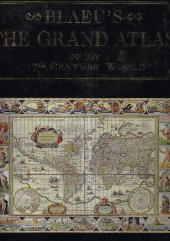
Blaeu's the grand atlas of the 17th century world
100 cartes en couleurs Cartonnage d'éditeur sous jaquetteilludtrée Très bon 1997 1 volume in-folio
Referência livreiro : 14153
|
|
|
CALCOLO DEI LATI.
(Codice OS/0217) Quaderno in 16°, 16 pp. La prima pagina è stata anticamente compilata. Brossura editoriale, un esempio alla copertina posteriore. Buono stato. ~~~ SPEDIZIONE IN ITALIA SEMPRE TRACCIATA

|
|
|
Campi Bisenzio
carta topografica cm. 58 x 50 margini inclusi, litografia in scala 1:25.000 delle zone di Campi, Signa, Peretola. Strappetto al marg. bianco infer. ma ottimo es.
|
|
|
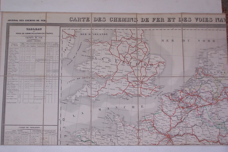
Carte des Chemins de Fer et des Voies Navigables de l'Europe Centrale.
P., Journal des Chemins de Fer, 1853. 115x75 cm, entoilée.
Referência livreiro : CF313
|
|
|
CARTE GEOGRAPHIQUE Physique et Politique des Royaumes d'ESPAGNE et de PORTUGAL indiquant toutes les routes principales et la division par provinces, accompagnée d'une partie de l'Afrique donnant toutes l'Algérie depuis le Détroit de Gibraltar jusqu'aux frontières de Tunis, dressée par Girard et Charles.
Paris Auguste Logerot 1854. Grande carte dépliante en couleurs, entoilée à l'époque, haute de 58cm, large de 88cm (19,5cm sur 12,5cm repliée), étiquette de l'éditeur appliquée sur la toile. Exemplaire en bon état, solide, complet.
Referência livreiro : GITg800
|
|
|
CARTE VELOCIPEDIQUE et touristique de France dressée avec le concours du Touring Club de France. FEUILLE XV MARSEILLE.
Paris Andriveau-Goujon Librairie Méa sans date vers 1900. Grande carte en couleurs entoilée à l'époque 63cm sur 90cm ouverte (16cm sur 11cm fermée), étiquette imprimée de l'éditeur appliquée sur la toile. Exemplaire en bon état et bien complet. (4431)
Referência livreiro : GITh071
|
|
 Receber por correio electrónico
 Descarregar em documento PDF
 Fluxo RSS
