|
|
|
Sequoia Natural History Association Eureka Cartography Illustrator
Rae Lakes Loop Trail Map
Sequoia Natural History Association 1999-01-01. Reprint 2005. Map. Good. Sequoia Natural History Association unknown
Bookseller reference : SONG1878441116 ISBN : 1878441116 9781878441119

|
|
|
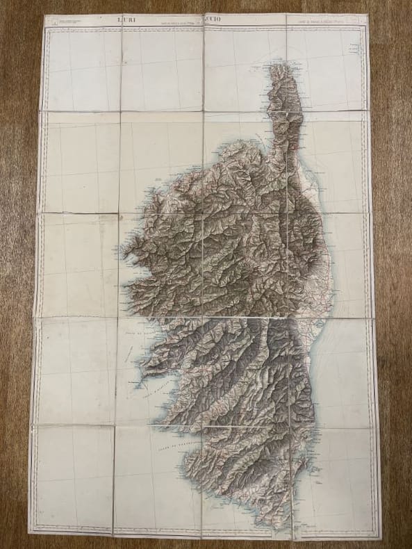
Service Géographique de l'Armée
Carte chorographique de la Corse entière, entoilée.
Service Géographique de l'Armée Service Géographique de l'Armée, sans date, vers 1900. La carte présente une mention de dernière révision à 1887. Format 68 x 105 centimètres, entoilée et lithographiée en couleurs, en 20 feuilles toutes présentes. Echelle 1/200 000. Quelques petits défauts sans gravité. Très bon exemplaire. Rare
Bookseller reference : 169205
|
|
|
Service Géographique de l'Armée - Section topographique
Croquis des étapes de la Division de CONSTANTINE au 500.000e
In-8 broché vert allongé. Carte dépliante en couleurs. Très bon état.
Bookseller reference : 16586
|
|
|
Service hydrographique de la Marine
Dispositions générales relatives aux cartes de l'hydrographie française. Signes conventionnels et abréviations. 2e édition.
Imprimerie Nationale, Paris, 1949. Un volume in-4 carré demi toile, cartonnage gris de l'éditeur, 50 pages et 29 feuillets de planches. Bel exemplaire.
Bookseller reference : 4427
|
|
|
Service Géographique de l'Armée - Officiers du Corps d'Etat Major
En un seul lot : 60 cartes d'Etat Major entoilées au 1/200 000e
Service Géographique se l'Armée, vers 1910. Ensemble de 60 cartes d'Etat Major entoilées et pliées en couleurs, la plupart au format 42 x 67 cms, quelques unes un peu plus petites et d'autres un peu plus grandes, toutes à l'échelle 1/200 000e. Toutes portes une étiquette manuscrite de localisation, certaines le tampon du Général Bouyssou (122e Rgt / Rodez). Chateauroux, Rennes, Vesoul, Vannes, Les Sables d'Olonne, Rouen, Poitiers, Le Puy, Amiens, Cherbourg, Tours, Nice, Orléans, Nantes, Nancy, Mulhouse, Moulins, Dijon, Annecy (2), Angoulême, Abbeville, Grand Saint Bernard, Brest, Berne, Lannion, Grenoble, Besonçon, Boulogne, Montpellier, Montauban, Méziéres (2), Limoges, Lorient, Aurillac, Dunkerque, Autun, Bressuire - La Roche sur Yon, Bourges, Chartres, Angers, Bergerac, Marseille-Antibes, La Rochelle-Niort, Chalons, Troyes, Saverne, Strasbourg, Laval, Lyon, Macon, Metz, Melun, Avignon, Carcassonne, Les Pieux-Guernesey, Caen, Tignes. Ensemble en bon état, seules deux cartes présentent une épidermure sans grande gravité. Ces cartes étaient remises aux Officiers lors de la mobilisation. Bel ensemble
Bookseller reference : 169683
|
|
|
Sereno,Paola. Sturani,Maria Luisa. (ed.).
Rural Landscape between State and Local Communities in Europe. Past and Present. Proceedings of the 16th Sessio
<br/> STATO: NUOVO.<br/> TITOLO: Rural Landscape between State and Local Communities in Europe. Past and Present. Proceedings of the 16th Session of the Standing European Conference for the Study of the Rural Landscape (Torino, 12-16 September 1994).<br/> AUTORE: Sereno,Paola. Sturani,Maria Luisa. (ed.).<br/> EDITORE: Edizioni dell'Orso<br/> DATA ED.: 1998,<br/> COLLANA: Coll. Geographica,1.<br/>

|
|
|
SERTORIO LOMBARDI CRISTIANA (a cura di).
Il Piemonte antico e moderno delineato e descritto da Clemente Rovere.
Due volumi di cm. 30, pp. cxxxvi (1) + 1351 pagine interamente illustrate. Legatura editoriale in mezza pelle, dorsi a nervi con titoli e fregi in oro. Entro custodia in cart. rigido. Perfetta conservazione, in stato di nuovo. Opera che presenta per la prima volta l'intero corpus fin'allora rimasto manoscritto e conservato nella Biblioteca di Deputazione Subalpina di Storia patria e riguardante oltre 4000 vedute e disegni d'interesse piemontese. Edizione a tiratura limitata e numerata.
|
|
|
Service cartographie Hachette education; Latitude Firme
Atlas de la France
Hachette 1996. Soft cover. Very Good. <br/> <br/> Hachette paperback
Bookseller reference : 004889 ISBN : 2011668069 9782011668066

|
|
|
Service cartographie Hachette education
Atlas du monde
1996-01-07. Good. Ships with Tracking Number! INTERNATIONAL WORLDWIDE Shipping available. May not contain Access Codes or Supplements. May be re-issue. May be ex-library. Shipping & Handling by region. Buy with confidence excellent customer service! unknown
Bookseller reference : 2011668077 ISBN : 2011668077 9782011668073

|
|
|
SERVICE GEOGRAPHIQUE DU LEVANT.
[MAP of SYRIA and LEBANON] Map of Syria and Lebanon. Scale: 1:1.100.000.
Very Good English Original color map folded in its papers. Very good. Folded. Atlas folio. (60 x 47 cm). In English. [MAP of FRENCH MANDATE SYRIA and LEBANON] Map of Syria and Lebanon. Scale: 1:1.100.000. No date.
|
|
|
Service Géographique de l'Armée
Carte chorographique de la Corse entière, entoilée.
Service Géographique de l'Armée, sans date, vers 1900. La carte présente une mention de dernière révision à 1887. Format 68 x 105 centimètres, entoilée et lithographiée en couleurs, en 20 feuilles toutes présentes. Echelle 1/200 000. Quelques petits défauts sans gravité. Très bon exemplaire. Rare

|
|
|
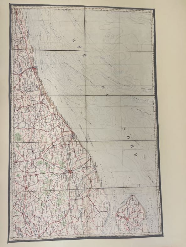
Service Géographique de l'Armée
S. te FOY-TARENTAISE BOURG-St. MAURICE MOÛTIERS TIGNES. Dessiné, héliogravé et piublié par le Service Géographique de l'Armée en 1934 d'après les travaux exécutés sur le terrain de 1885 à 1903. révisé en 1928.
Grande carta geografica a bellissimi COLORI telata di cm.112x81,2 (32 settori applicati su robusta tela grigia editoriale). Al verso sono applicate le indicazioni editoriali e tecniche e i simboli. e la déclinaison magnètique 1934 e sua variazione annuale."L'équidistance des courbes est de 20 mètres pour la France, et de 25 mètres pour l'Italie". Indica: routres nationale, chemens de grande communication, régulièrementr ou irrég. entretenus, d'exploitation, laie f.re, sentier, layon, muletier; chemins de fer à deux ou une voie, à voie étroite, câbles trasporteurs de force électrique, d'exploitation; camal d'alimentation. Source, fontaine, puits, réservoir. Groupe fortifié, Fort. Limites. Bois, Broussalille, Vergers, Jardins Vignes, Prés. Eglise, Chapelle isolée, Calvaire. Moulins à vent, à eau. Carrières à ciel ouvert, souterrainea. Poimts géodésiques, Point coté. Population (en milliers d'habitants).
|
|
|
Service Géographique de l'Armée - Officiers du Corps d'Etat Major
En un seul lot : 60 cartes d'Etat Major entoilées au 1/200 000e
Service Géographique se l'Armée, vers 1910. Ensemble de 60 cartes d'Etat Major entoilées et pliées en couleurs, la plupart au format 42 x 67 cms, quelques unes un peu plus petites et d'autres un peu plus grandes, toutes à l'échelle 1/200 000e. Toutes portes une étiquette manuscrite de localisation, certaines le tampon du Général Bouyssou (122e Rgt / Rodez). Chateauroux, Rennes, Vesoul, Vannes, Les Sables d'Olonne, Rouen, Poitiers, Le Puy, Amiens, Cherbourg, Tours, Nice, Orléans, Nantes, Nancy, Mulhouse, Moulins, Dijon, Annecy (2), Angoulême, Abbeville, Grand Saint Bernard, Brest, Berne, Lannion, Grenoble, Besonçon, Boulogne, Montpellier, Montauban, Méziéres (2), Limoges, Lorient, Aurillac, Dunkerque, Autun, Bressuire - La Roche sur Yon, Bourges, Chartres, Angers, Bergerac, Marseille-Antibes, La Rochelle-Niort, Chalons, Troyes, Saverne, Strasbourg, Laval, Lyon, Macon, Metz, Melun, Avignon, Carcassonne, Les Pieux-Guernesey, Caen, Tignes. Ensemble en bon état, seules deux cartes présentent une épidermure sans grande gravité. Ces cartes étaient remises aux Officiers lors de la mobilisation. Bel ensemble

|
|
|
Service HYDROGRAPHIQUE de la Marine
De PORTO-VECCHIO au CAP PERTUSATO, Bouches de Bonifacio. [CARTA NAUTICA] Echelle 1:35.680. Con le isole CERBICALE, LAVEZZI, CAVALLO, Razzoli, La Presa ecc.
Carta nautica di cm. 105,2x74 su forte carta, ripiegata. Include le isole CERBICALE, LAVEZZI, CAVALLO, Razzoli, La Presa ecc. Carte levée en 1884 et 1890, 1894, sondes en mètres. Tracce di gualcitura e di polvere, ma integra e robusta. Gravé: le trait par Francoz, la topographie par DELAUNE, la lettre par Er. Dumas Vorzet.
|
|
|
Sestini Aldo
L'opera scientifica del socio straniero Carl Troll
|
|
|
SESTINI ALDO
La lettura delle carte geografiche (Con cenni sugli esercizi cartografici e sulla storia della cartografia)
16° bross. edit. pp. 156, (8 di tabelle) Con 78 figure nt. e 2 tavole f.t. "Manualetti". Poche sottolin. a lapis.

|
|
|
Sestini, Aldo
La Lettura delle Carte Geografiche Con Cenni Sugli Esercizi Czrtografici e Sulla Storia Della Cartografia
Mm 130x190 Brossura editoriale di pagine 162 (8) con illustrazioni in nero nel testo e due tavole fuori testo di cui una a colori, diffuse sottolineature a matita, fioriture ai piatti. Spedizione in 24 ore dalla conferma dell'ordine.

|
|
|
Sestini,Aldo. Nice,Bruno. Mori,Alberto ed altri.
L'Italia fisica.
<br/> STATO: USATO, MOLTO BUONO.<br/> TITOLO: L'Italia fisica. <br/> AUTORE: Sestini,Aldo. Nice,Bruno. Mori,Alberto ed altri.<br/> EDITORE: Touring Club Italiano<br/> DATA ED.: 1957,<br/> COLLANA: Coll.Conosci l'Italia,1.<br/>
|
|
|
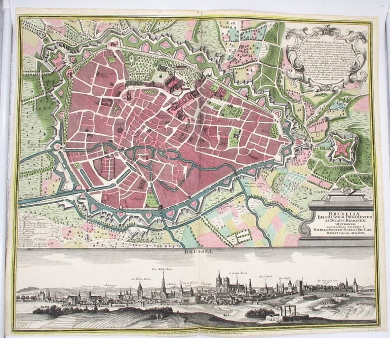
SEUTTER (Matthäus)
Bruxeliae Belgii Cathol. Ornamentum et Ducatus Brabantiae Metropolis accuratissima aeri incia a Matthaeo Seuttero (Bruxelles, Brussel).
Augsburg (Allemagne), Seutter Matthäus, circa 1740. 59 x 51 cm (pliure centrale, déchirure restaurée au bas de la planche).
Bookseller reference : 15866
|
|
|
SEUTTER MATTEUS
Insula et Regnum Sardiniae
Augsburg 1730 Incisione originale su rame, mm 500 x 580 e margini, abilmente colorata da mano coeva. Bella e raffinata carta geografica della Sardegna tratta dall'Atlas Novus del Seutter pubblicato ad Augsburg nel 1730 ca. In alto a sinistra il titolo entro importante cartiglio animato da personaggi, flora e fauna di carattere allegorico. In basso altri due cartigli con le scale metriche e lo stemma di Vittorio Amedeo II di Savoia, nel quale è inserito anche lo stemma sardo. La mappa è basata sulla medesima rappresentazione dell'isola disegnata dal Coronelli nel 1680.
Bookseller reference : 21072
|
|
|
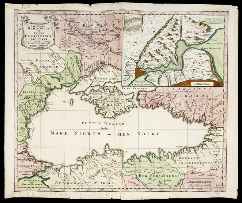
Seutter, Matthias (1678–1757):
Nova Mappa Maris Nigri et Freti Constantinopolitani.
Augsburg, 1741. Altkolorierter Kupferstich. Blattgrösse: 49.4 x 57.8 cm
Bookseller reference : 986DG
|
|
|
SEUTTER MATTHAUS
DUCATUS CARNIOLAE VINDORUM MARCHIA ET HISTRIA
SEUTTER MATTHAUS DUCATUS CARNIOLAE VINDORUM MARCHIA ET HISTRIA. , 1730, La carta è uno dei rifaciamenti della tavola "Tabula Ducatus Carniola, Vindorum Marchiae et Histriae" di Johann Baptiste Homann realizzata dopo il 1716. Buono (Good) Buon es. - piccoli strappi nel margine superiore. acquaforte acquerellata in epoca <br> cm. 58 x 49.5 <br> <br> <br>

|
|
|
Seutter Matthaus
Quattro continenti: Europa, Africa, Asia, Novus Orbis sive America
Proveniente da : "Atlas novus sive tabulae geographicae totius orbis faciem, partes, imperia, regna et provincias exhibentes, exactissima cura juxta recentissimas observation. aeri incisae et venum expositae a Matthaeo Seutter chalcogr". Prima edizione.

|
|
|
SEUTTER MATTHAUS.
Dominium Venetum cum adjacentibus Mediolan. Mant. Mutinensi, Mirandol., Parmen., Placent. Ducat.
Carta di mm 198x260, ripiegata tre volte e inserita in busta editoriale (mm 108x73) con unghiatura e bel cartiglio allegorico che ne ripete il titolo. La carta geografica, conforme a quella impressa nell’Atlas minor (Augsburg, Lotter, 1750), reca nell’angolo superiore sinistro, su cartiglio allegorico, il titolo, e nell’inferiore destro le scale geografiche; stampata su carta forte e finemente acquerellata a più colori da mano coeva; stato di conservazione molto buono LIB - (B - V)
|
|
|
SEUTTER MATTHAUS.
Ducatus Sabaudiae Princip. cum adjacentibus Mediolan. Mant. Mutinensi, Mirandol., Parmen., Placent. Ducat.
Carta di mm 199x262, ripiegata tre volte e inserita in busta editoriale (mm 108x73) con unghiatura e bel cartiglio allegorico che ne ripete il titolo. La carta geografica, conforme a quella impressa nell’Atlas minor (Augsburg, Lotter, 1750), reca nell’angolo superiore destro, su cartiglio allegorico, il titolo, e nell’inferiore destro le scale geografiche; stampata su carta forte e finemente acquerellata a più colori da mano coeva, è in ottimo stato di conservazione LIB - (B - V)
|
|
|
SEUTTER, GEORG. MATTHAUS (SEUTTER, MATTH.).
Reipublicae Genuensis Dominium.
Augusta, 1740 circa. Incisione in rame, colore d’epoca, cm 50 x 58 (alla lastra). Se le carte del Seutter in molto assomigliano a quelle dell’Homann, tanto da non essere talvolta subito distinguibili, ciò che maggiormente le differenzia riguarda il cartiglio, spesso enormemente accresciuto con figure che si rifanno al mito, piuttosto che a qualche potente cui sia dedicata la stampa. Inoltre, non di rado, nella parte inferiore dl foglio, trovano spazio degli scorci di città, cosa che costituisce una su caratteristica peculiare rispetto ad altri editori, anche del passato. Esemplare con un’impressione un po’ stanca e un leggero foxing al margine bianco, nell’insieme discreto stato.

|
|
|
SEUTTER, GEORG. MATTHAUS (SEUTTER, MATTH.).
Republicae Genuensis Dominium.
Augusta, 1740 ca. Incisione in rame, colore d’epoca, cm 50 x 58 (alla lastra). Se le carte del Seutter in molto assomigliano a quelle dell’Homann, tanto da non essere talvolta subito distinguibili, ciò che maggiormente le differenzia riguarda il cartiglio, spesso enormemente accresciuto con figure che si rifanno al mito, piuttosto che a qualche potente cui sia dedicata la stampa. Inoltre, non di rado, nella parte inferiore dl foglio, trovano spazio degli scorci di città, cosa che costituisce una su caratteristica peculiare rispetto ad altri editori, anche del passato. Bell’esemplare, in margini, in bella coloritura e in bella impressione.

|
|
|
SEUTTER, GEORG. MATTHAUS (SEUTTERI, MATTHAEI).
Principali dignitate gaudens comitat. Tirolis Episcopat. Tridentinum et Brixiensem.
Augusta, 1740 circa. Tratta dall “Atlas novus indicibus instructus”, incisione in rame, colore d’epoca, cm 50 x 58 (alla lastra). Carta raffigurante il territorio tirolese, l'impostazione è molto simile alla carta di J.B. Homann edita nel 1716. Anche le decorazioni che accompagnano il titolo ricordano quella dell' Homann, con la fortezza di Covelo sullo sfondo e diverse figure allegoriche nel primo piano. (Bibl. “Il territorio trentino - tirolese nell’antica cartografia” di Gino Tomasi, scheda n. 56). Ingiallimento della brachetta centrale, peraltro a pieni margini e in buono stato di conservazione.

|
|
|
SEUTTER, GEORGE MATTHAUS IL VECCHIO.
Neapolis Regnum quo continentur Aprutium Ulterius et Citer.
Augsburg, 1730 circa. Tratta da "Atlas Minor", 1750 circa. Incisione in rame all'acquaforte, coloritura coeva, cm 21 x 27,2 (alla lastra). Carta geografica della parte meridionale della penisola, con bel cartiglio decorato nella parte superiore, vascelli in mare e piccola scenetta col crateri fumanti in basso a destra. Bella la coloritura, buono lo stato di conservazione.

|
|
|
SEUTTER, MATTHEO – LOTTER, CONRAD - KAEMPFERO, ENGELBERTO.
Regni Japoniae. Nova mappa geographica, ex indigenarum observationibus delineata.
Augusta Vindelicrum, Norimberga, 1730 circa. Da "Atlas Novus", edito tra il 1728 e il 1730. Incisione in rame all'acquaforte, coeva coloritura a mano, cm 50 x 59 circa (il foglio) più margini. Grande e ricco cartiglio in alto a sinistra, con figure di studiosi orientali, una rosa dei venti al centro, in basso alcuni schemi riportano simboli della cultura e della civiltà giapponese, margine graduato su tutto il perimetro. Esemplare in tenue coloritura, sparse e piccole fioriture, due piccoli strappi al margine inferiore, in margini e in buono stato di conservazione. .

|
|
|
SEUTTER, MATTHEUS (SEUTTERO, MATTEO).
Gli Stati del Sommo Pontefice chiamati il Patrimonio di San Pietro con insieme il Latio Vecchio et Campagna di Sabina. Carta Geografica esattamente delineata.
Augusta, 1740 circa. Incisione in rame all’acquaforte, colore d’epoca, cm 48,5 x 56,5 (la parte figurata) 49,5 x 58,5 (alla lastra) più margini bianchi. Delineata dal Seutter (il nome nel cartiglio) e incisa dal Tob. Conr. Lotter (il nome n lastra in basso a destra), splendida mappa della zona di Roma, con le regioni circostanti chiaramente delineate e indicate. Magnifico il cartiglio con titolo e Autore circondato da decori, e, in un paesaggio boschivo, una tenda regale che contiene una corona d'oro custodita da cherubini. Esistono della stampa due diverse versioni, con due diversi cartigli, questa la meno comune e con il cartiglio più bello. Leggermente rifilato il margine superiore bianco, peraltro in bella impressione e in bellissima coloritura, molto buono lo stato di conservazione.

|
|
|
SEUTTER, MATTHEUS.
Cursus Padi per Longobardiam a Fonte usque a ostia cum fluminibus que in illum se exonerant et adjacentibus Ducatibus ac Principatibus quos interluit et qui confinis sunt, Tribus Combinandis tabellis.
Augusta, 1740 circa. Incisione in rame all’acquaforte, incisa su tre fogli, colore d’epoca, cm 58,5 x 133,5 (alla lastra). Cartouche in alto al centro, circondata da figure allegoriche e con gli stemmi della Savoia, Piemonte, Monferrato, Milano, Parma, Modena, Mantova, Ferrara, Bologna e Venezia; cartiglio altrettanto riccamente decorato e allegorizzato in basso a sinistra. Opera tra le più importanti di Matthaeus Seutter, questa carta rappresenta la descrizione geografica del corso del fiume Po, con i territori interessati e quelli adiacenti, dalle sorgenti alla foce, comprendendo praticamente tutta l’Italia del Nord, con la designazione dei vari Ducati, Repubbliche e Legazioni. Matthaus Seutter (1678 -1756), dopo un apprendistato presso gli Homann a Norimberga, si trasferì ad Augsburg verso il 1720, e qui aprì la propria attività superando il maestro sotto il profilo della bellezza: le sue carte hanno sempre colori brillanti e cartigli elaborati. Minimamente rifilato il margine laterale sinistro in prossimità della battuta, stretti i margini sugli altri lati ma trattasi di ottimo esemplare in bella coloritura e in magnifico stato di conservazione.

|
|
|
SEUTTER, MATTHEUS.
Ducatus Mantuani quam castigatissima delineatio.
Augusta, 1730 circa. Incisione in rame all’acquaforte, colore d’epoca, cm 50,5 x 58,5 (alla lastra) più stretti margini, ricco cartiglio con figure in alto a sinistra. Una piccola mancanza dell’inciso su una delle figure al cartiglio, èperaltro in bella coloritura e in ottimo stato di conservazione.

|
|
|
Seutter, Matthias (1678?1757)
Nova Mappa Maris Nigri et Freti Constantinopolitani.
Augsburg, 1741. Altkolorierter Kupferstich. Blattgrösse: 49.4 x 57.8 cm + Wichtig: Für unsere Kunden in der EU erfolgt der Versand alle 14 Tage verzollt ab Deutschland / Postbank-Konto in Deutschland vorhanden +, 986DG
Bookseller reference : 986DG

|
|
|
Seutter, Matthias (1678?1757)
Pagi Tigurini.
o.J. Kol. Kupferstichkarte. Rahmengrösse: 59 x 69 cm. + Wichtig: Für unsere Kunden in der EU erfolgt der Versand alle 14 Tage verzollt ab Deutschland / Postbank-Konto in Deutschland vorhanden +, Abb.
Bookseller reference : 830CG

|
|
|
Seutter, Matthäus
Mappa Geographica in qua Ducatus Lotharingiae et Barr ut et Episcopatuum Metens. Tullens. Verdunens. [Um 1730]. [altkolorierter Kupferstich, gerahmt / handcolored copper engraving, framed].
o.J. Matthäus Seutter (Matthias Seutter), geboren 1678 in Augsburg; gestorben 1757 ebenda. [3 Warenabbildungen]
Bookseller reference : 59009BB

|
|
|
Seutter, Matthäus
Peloponnesus Hodie Morea. [Um 1730]. [altkolorierter Kupferstich, gerahmt / handcolored copper engraving, framed].
o.J. Matthäus Seutter (Matthias Seutter), geboren 1678 in Augsburg; gestorben 1757 ebenda. [3 Warenabbildungen]
Bookseller reference : 59008BB

|
|
|
Seutter, Matthäus
XVII. Provinciae Belgii sive Germaniae Inferioris priscis temporib...[Um 1730]. [altkolorierter Kupferstich, gerahmt / handcolored copper engraving, framed].
o.J. Matthäus Seutter (Matthias Seutter), geboren 1678 in Augsburg; gestorben 1757 ebenda. [3 Warenabbildungen]
Bookseller reference : 59007BB

|
|
|
SEYMOUR H. / ROSE William and Fanny.
A TOUR to GREAT ST BERNARD'S and round MONT BLANC. with Descriptions copied from a Journal kept by the Author; and drawings taken from Nature. intended for young persons from ten to fourteen Years of Age.
1827 1827 London. printed for Harvey and Darton, Gracechurch - street. 1827 . Un volume petit in 8. percaline éditeur bleue en trés bon état , les coins et plats en parfait état , dos légèrement insolé comme souvent. toutes tranches dorées. Ex libris sur pages de gardes. carte repliée en regard de la page de titre. " A Map of the country round Great St Bernard and Mount Blanc with the route of the Tourists ". Titre + iv pp + 144 pp. avec 8 Planches hors texte comprenant chacune 2 illustrations. Soit 16 jolies gravures sur acier textées. EDITION ORIGINALE. COMPLET.BEL EXEMPLAIRE en très bon état intérieur et extérieur et en cartonnage éditeur époque.
Bookseller reference : 2678
|
|
|
SHERRER C.
Niederlande - Belgien und Luxembourg. Carte N° 40, extraite de Stielers Hand-Atlas.
- Carte 40 x 50 cm, pliée en 2.
Bookseller reference : 70145
|
|
|
SHERRER C. - HABENICHT H.
Ostalpen. (Alpenländer : Westlisches Blatt.) Carte N° 15, extraite de Stielers Hand-Atlas.
- Carte 40 x 50 cm, pliée en 2.
Bookseller reference : 70139
|
|
|
SHERRER C. - HABENICHT H.
Schweiz. (Alpenländer : Westlisches Blatt) Carte N° 14, extraite de Stielers Hand-Atlas.
- Carte 40 x 50 cm, pliée en 2.
Bookseller reference : 70138
|
|
|
SHERRER C. - KOFFMAHN O.
Thüringishe Staaten. Carte N° 13, extraite de Stielers Hand-Atlas.
- Carte 40 x 50 cm, pliée en 2.
Bookseller reference : 70137
|
|
|
Shirley Rodney W
Early Printed Maps of the British Isles : A Bibliography 1477-1650 Revised Edition
London: Holland Press 1980. Brand New in perfect condition. NO rubbing. NO fading. Bright clean square and tight. Sharp corners. NO owner's name or bookplate. NO remainder mark. Fresh and crisp -- obviously never read. Revised Edition. 1980. 88 plates. In 1973 a preliminary version of this work appeared in 5 issues of the periodical MAP COLLECTORS' CIRCLE. For this 1980 revision an index has been added as well as 97 new or corrected entries. Described and commented on are over 700 maps of the period. A final chronological listing identifies the cartographer date of publication and gives an estimate of rarity for each map's principal edition or first state. Volume #5 in The Holland Press Cartographica series. Bound in the original gilt-stamped dark green boards. 7.5" wide by 10" tall. 1980 Revised Edition. Hardcover. New/No jacket. xxv 188pp. Great Packaging Fast Shipping. Holland Press Hardcover
Bookseller reference : 017928 ISBN : 0900470976 9780900470974
|
|
|
Shirley Rodney W
Early Printed Maps of the British Isles : A Bibliography 1477-1650 Revised Edition
London: Holland Press 1980. Near Fine condition. Bright clean square and tight. Sharp corners. NO owner's name or bookplate. NO remainder mark. Fresh and crisp -- probably never read. Revised Edition. 1980. 88 plates. In 1973 a preliminary version of this work appeared in 5 issues of the periodical MAP COLLECTORS' CIRCLE. For this 1980 revision an index has been added as well as 97 new or corrected entries. Described and commented on are over 700 maps of the period. A final chronological listing identifies the cartographer date of publication and gives an estimate of rarity for each map's principal edition or first state. Volume #5 in The Holland Press Cartographica series. Bound in the original gilt-stamped dark green boards. 7.5" wide by 10" tall. 1980 Revised Edition. Hardcover. Near Fine condition/No jacket. xxv 188pp. Great Packaging Fast Shipping. Holland Press Hardcover
Bookseller reference : 018076 ISBN : 0900470976 9780900470974
|
|
|
SHIRLEY RODNEY W
THE MAPPING OF THE WORLD EARLY PRINTED WORLD MAPS 1472 - 1700.
IN 4° gr.( cm.26 X 35 ), pp.669. LEGATURA EDITORIALE TELATA RIGIDA + SOVRACOPERTINA ILLUSTRATA A COLORI CON TITOLO. SGUARDIE FIGURATE. 440 ILLUSTRAZIONI in b/n/col. DI PLANISFERI DELLE VARIE EPOCHE. OPERA FONDAMENTALE PER LA CATALOGAZIONE DEI PLANISFERI E DEI LORO AUTORI, DAL 1472 AL 1700. NUOVA EDIZIONE AGGIORNATA.<BR>OTTIMA CONSERVAZIONE. RARO. ID, 6767

|
|
|
Shirley Rodney W.
The Mapping of the World. Early Printed World Maps 1472 - 1700. Volune nine.
Ril. in tela con sovr.ill. a col., cm 34,5x24,5, pp 669, moltissime ill. a col. e b/n.. Come nuovo. - ISBN: o946323038

|
|
|
SHIRLEY Rodney W. -
Early Printed Maps of the British Isles 1477-1650.
England, Antique Atlas Publications, 1991, 4to (cm. 30,5 x 21,5) legatura tutta tela con titoli dorati al piatto anteriore e al dorso e sovraccopertina illustrata a colori, pp. XX-233 con 160 carte nel testo.

|
|
|
SIDER (Sandra) ANDREASIAN (Anita) & CODDING (Mitchell)
Maps, Charts, Globes: Five Centuries of Exploration. A New Edition of E. L. Stevenson's Portolan Charts and Catalogue of the 1992 Exhibition.
First Edition, 4to, 73 plates (some coloured), orig. cloth, d.w. Catalogue of the Society's manuscript portolan charts covering material from the fifteenth through the seventeenth century.
|
|
|
SILVESTRE Marguerite, FINCOEUR Michel-Benoit
"Inventaire raisonné des collections cartographiques Vandermaelen, conservées à la Bibliothèque Royale de Belgique (4 volumes); tome 1 : Cartes de Belgique; tome 2 : Carte topographique de la Belgique au 1 : 20 000; tome 3 : Villes et communes de Belgique (hors Bruxelles); tome 4 : Bruxelles."
Bruxelles, Bibliothèque Royale Albert 1er, 1994-2000. 21 x 28, 4 volumes, xxviii-563 + 335 + xxx-466 + xxx-546 pages, très nombreux figures, plans et cartes en N/B et en couleurs, reliure d'édition pleine toile bleue, très bon état (1 cachet d'ex-propriétaire au bas de la page de garde dans chaque volume).
Bookseller reference : 91651
|
|
|
 Receive by email
 Download as PDF document
 RSS feed


