|
STARCK-MAN (P.).
Tabula Itineris, & Stationum Israelitarum in Deserto ab eurom egressu ex Aegypto ad transitum Ioardamis.
Sin lugar ni año (Siglo XVIII), mapa grabado en madera, de 32'5 x 44,5 cm.
|
|
|
Stark, E
Die Genauigkeitsstruktur im photogrammetrischen Einzelmodell. Diss.
München, 1973. 4°. 152 S. OBr. Klammern angerostet. Umschl. etwas angeschmutzt u. m. St. sowie Sign. (BAW. Veröff. d. Dt. Geodät. Komm. C 193).
Bookseller reference : 162379
|
|
|
STATI-UNITI DELL'AMERICA SETTENTRIONALE dalle più recenti mappe.
Carta incisa in rame e acquarellata a mano.
Carta di cm 36 x 48,5 alla battuta, più i margini, su tav. piegata a metà. Tratta da 'Atlante storico, geografico, genealogico, cronologico e letterario di M. A. Le Sage in ogni sua parte corretto, ampliato e proseguito sino all'anno corrente. Prima Veneta Edizione'.
|
|
|
Stavenhagen, W
Skizze d. Entwicklung u. d. Standes d. Kartenwesens d. außerdeutschen Europas.
Gotha, Perthes, 1904. 4°. XXVIII, 376 S. Ohne Umschl. M. Kleberest v. ehemaliger Bind. Schnitt u. letzte S. etwas stockfl. St. a. Tit. (Petermanns geogr. Mitteil. Erg.-H. 148).
Bookseller reference : 213882
|
|
|
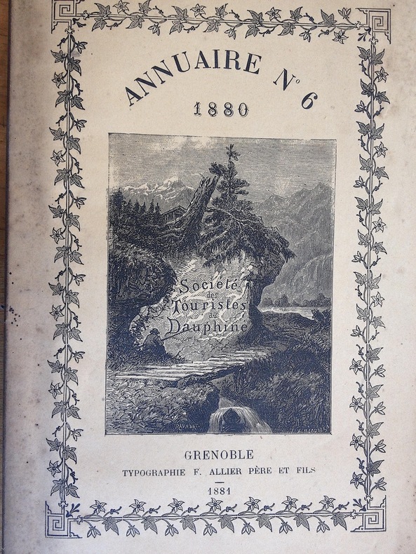
STD. Société des Touristes du Dauphiné.
SOCIETE DES TOURISTES DU DAUPHINE. Annuaire N° 6. 1880 . 6 ème année.
1881 1881 Edité à Grenoble chez Allier. 1881. Un volume in 8. broché; non coupé. 216 pages. Une très belle carte hors texte en couleurs plusieurs fois repliée, représentant la carte historique des Vallées Vaudoises par A. de Rochas d'Aiglun. éditée par le Spectateur Militaire. intérieur très frais. dos bruni comme souvent.
Bookseller reference : 2392
|
|
|
Sterling.Tom.
L'Amazzonia.
<br/> STATO: USATO, COME NUOVO.<br/> TITOLO: L'Amazzonia. <br/> AUTORE: Sterling.Tom.<br/> EDITORE: Mondadori<br/> DATA ED.: 1986,<br/> COLLANA: Collana Grandi Distese Selvagge.<br/>
|
|
|
Stern M. F
Map Collectors' Circle Series Second Year Volume 2 No 15 : Ancient Maps and Explorers' Routes on Stamps
London: Map Collectors' Circle 1964. Very Good condition. Clean and unmarked. NOT a library discard. NO owner's name or bookplate. 1964. First Edition. 81 illustrations of stamps showing ancient maps and explorers' routes. Gives commentary on map sources and errors historical background etc. Cross referenced to Scott Stanley Gibbons and Michel. Bound in the original tan wraps printed in black. 7.25" wide by 9.75" tall. First Edition. Softcover. Very Good condition. 22pp. Great Packaging Fast Shipping. Map Collectors' Circle Paperback
Bookseller reference : 018913
|
|
|
Stern, Friedel
Israel: In Pictorial Maps [AS IS]
AS IS. 34x28.5 cm. Irregularly numbered pages. Hardcover. Cover and spine are dirty and slightly scuffed. Front and back white pages are slightly damaged. Front cover page is slightly stained. Else in good condition. PLEASE NOTE: This item is overweight. We may ask for extra shipping costs.
|
|
|
Stewart,Robert.
Il Labrador.
<br/> STATO: USATO, COME NUOVO.<br/> TITOLO: Il Labrador. <br/> AUTORE: Stewart,Robert.<br/> CURATORE: Fotografie di Pierre Boulat.<br/> EDITORE: Mondadori<br/> DATA ED.: 1986,<br/> COLLANA: Collana Grandi Distese Selvagge.<br/>
|
|
|
Stieler Adolph e Berghaus Ermann
Stieler Adolph e Berghaus Ermann. Atlante scolastico per la geografia politica e fisica
22838 Stieler Adolph e Berghaus Ermann Stieler Adolph e Berghaus Ermann. Atlante scolastico per la geografia politica e fisica. N. D., Gotha: Giusto Perthes 1861 - I italiano, in ottavo pp. non numerate Atlante scolastico di fine ottocento. Copertina cartonata molto usurata. Pagine leggermente ingiallite e usurata ad angoli e bordi. Leggeri segni a matita sulla prima pagina.

|
|
|
STIELER, Adolf.
Stielers Hand- Atlas. Über alle Theile der Erde und über das Weltgebäude.- Ed. 1877.
Hardcover in-folio (25,5 x 39 cm) , 90 cartes gravées sur cuivre (frontières en couleurs) double pages, reliure demi-basane d'époque, dos à nerfs en partie manquant. Plats et coins frottés, manques importants au dos, intérieur en très bon état. [P-53]
|
|
|
STIELER, Adolf.
Stielers Hand-Atlas. Über alle Theile der Erde und über das Weltgebäude.- Ed. 1877.
Gotha, Justus Perthes, sans date (1877). Hardcover in-folio (25,5 x 39 cm) , 90 cartes gravées sur cuivre (frontières en couleurs) double pages, reliure demi-basane d'époque, dos à nerfs en partie manquant.
Bookseller reference : 78383
|
|
|
Stockholms Auktionverk -
Rare maps, atlases & plate books from Ericsberg's Castle.
Stockholm, 2008, 4to legatura editoriale, pp. 158 con circa 400 schede prezzate

|
|
|
Stokes I. N. Phelps; Isaac Newton Phelps Stokes 1867 1944
The Iconography of Manhattan Island 1498-1909: Volume III first edition Vol. 3 Three
New York: Robert H. Dodd 1918. SEE PHOTOS. Appears unread. Near Fine condition. Mild EX-LIBRARY with NO library markings on the spine cover or edges of the textblock. SEE PHOTOS. Library markings on the endpapers title page copyright page and on the blank side of plates small ink stamp. All other pages are crisp clean and unmarked -- probably never read. Sharp corners. Bright and shiny. 1918. Limited First Edition. This is one of 360 copies on English handmade paper there were 42 others on vellum. Vol. III only: xxviii 1026pp 206 plates tissue-guarded some folding unlike reprint editions. Includes a wealth of maps documents photographs engravings and other illustrations from original sources. Top edge gilt. Bound in the original blue cloth with vellum spine and corners stamped in bright gold. The medallions gilt-stamped on the front and rear covers are still as bright and shiny as new. SEE PHOTOS. Full title: "The Iconography of Manhattan Island 1498-1909: Compiled from Original Sources and Illustrated by Reproductions of Important Maps Plans Views and Documents in Public and Private." Oversize Hardcover. 8.25" wide by 11.25" tall by 2.5" thick. This large heavy book will require extra postage for Priority and International shipments but only the standard charge for media mail. Howes U.S. IANA 1026: "Most elaborate und comprehensive history of New York City.". First Edition Limited to 360 copies. Oversize Hardcover. Near Fine EX-LIBRARY. Illus. by 1918 First Edition Limited to 360 copies. xxviii 1027pp 206 plates. Great Packaging Fast Shipping. Robert H. Dodd Hardcover
Bookseller reference : 023099

|
|
|
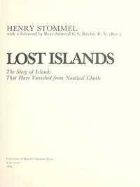
Stommel Henry
Lost Islands : The Story of Islands That Have Vanished from Nautical Charts new in publisher's shrinkwrap
Vancouver: University of British Columbia Press 1984. Brand New in a Brand New dust jacket. Perfect condition. STILL SEALED in the publisher's clear plastic SHRINKWRAP. NO chips. NO tears. NO creases. NO rubbing. NO fading. Bright clean square and tight. Sharp corners. NO owner's name or bookplate. NO remainder mark. Fresh and crisp -- obviously never read. Oversize Hardcover. 8.75" wide by 11.25" tall. In a pocket at the rear are huge foldout reproductions of early 19th century Admiralty charts of the Indian Ocean 1817 and Pacific Ocean 1859 where most of the islands mentioned in the text are located. The charts measure 46" wide by 26" tall when unfolded. The text is illustrated with 11 portraits and old prints plus 23 additional maps 4 double-page. Bound in the original light gray cloth stamped in shiny gold on the spine. Published price was $45. From the Dust Jacket: "During the 19th century and well into the 20th nautical charts and general atlases showed many islands which today are known not to have existed� Stommel describes how these little pin-pricks of land got on to the charts who 'discovered' them who expunged them and why some were so long-lived. It is a chronicle of poor navigation misprints falsifications optical illusions wild whalers' tales wistful hopes and a few real islands which rose and fell beneath the waves.". First Edition. Hardcover. New/in publisher's shrinkwrap. Illus. by Barbut Victoria jacket design. xxi 146pp. Great Packaging Fast Shipping. University of British Columbia Press Hardcover
Bookseller reference : 015793 ISBN : 0774802103 9780774802109
|
|
|
Stone Jeffrey
ILLUSTRATED MAPS OF SCOTLAND : From Blaeu's Atlas Novus of the 17th Century
London: Studio Editions 1991. 94pp. 46 full colour plates each with a facing text description. Originally pub. 1654. 1st edition. Hardback. Fine/V G sunned. folio. Studio Editions Hardcover
Bookseller reference : S265
|
|
|
STONE, J.C
(Ed.) Norwich's Maps of Africa. An illustrated and annotated carto-bibliography. Oscar I. Norwich. Bibliographical descriptions by Pam Kolbe. Second edition. Revised and edited by J. C. Stone.
(Norwich), Terra Nova Press, (1997). 4to. 37, (1) S., 408 S. m. zahlr., teils farbigen Abb., 1 Bl. OLwd m. OUmschlag (Umschlag minimal gebrauchsspurig).
Bookseller reference : 1247024
|
|
|
Stopp Prof. Dr. K
Map Collectors' Circle Series Fourth Volume Vol. IV No. 35 : Maps of Germany with Marginal Town Views
London: Map Collectors' Circle 1967. Near Fine condition. Clean and unmarked. NOT a library discard. NO owner's name or bookplate. Describes 44 maps from 1607 to 1680. 2 indexes. Illustrated with 22 plates. Bound in the original tan wraps printed in black. 7.25" wide by 9.75" tall. First Edition. Softcover. Near Fine condition. 43pp. Great Packaging Fast Shipping. Map Collectors' Circle Paperback
Bookseller reference : 018897
|
|
|
Stoppani Antonio
Il bel paese. Conversazioni sulle bellezze naturali, la geologia e la geografia fisica dell'Italia

|
|
|
Stoppani,Antonio.
Il Bel Paese.
<br/> STATO: USATO, ACCETTABILE.<br/> NOTE: Il volume è da rilegare, al copertina è staccata.<br/> TITOLO: Il Bel Paese. <br/> AUTORE: Stoppani,Antonio.<br/> CURATORE: Conversazione sulle bellezze naturali, la geologia e la geografia fisica d'italia.<br/> EDITORE: Cogliati<br/> DATA ED.: 1908,<br/>
|
|
|
Storms, Martijn
Maps that made History. 1000 Years of World History in 100 old Maps
Lannoo Publishers, Tiel - Leiden University Libraries, Leiden, 2022. 431 S. ; 34,5 x 28,5 cm ; Pp. ;
Bookseller reference : 124530

|
|
|
Stouraiti Anastasia
La Grecia nelle raccolte della Fondazione Querini Stampalia
n. 10 bross. edit. con bandelle, dorso muto, lieve macchia in cop.

|
|
|
Strabo / Jones, Horace Leonard [Trans.]
The Geography of Strabo: Based in Part upon the Unfinished Version of John Robert Sitlington Sterrett - In Eight Volumes [VOLUME VII IS MISSING] [SERIES]: The Loeb Classical Library
VOLUME VII IS MISSING. VOL. II, III, IV, V, VIII Contains folded maps. [VOL. I]: Books I-II / [VOL. II]: Books III-V / [VOL. III]: Books VI-VII / [VOL. IV]: Books VIII-IX / [VOL. V]: Books X-XII / [VOL. VI]: Books XIII-XIV / [VOL. VIII]: Book XVII & General Index. [ALL VOLUMES]: 11.5x16.5 cm. xliii+531+v+479+397+465+541+397+510 pages. Gilt hardcover. Top and bottom of spine are chafed. Pencil writing on several pages. [VOL. II]: Top of spine is worn. [IN CONCLUSION]: Else in good condition. PLEASE NOTE: This item is overweight. We may ask for extra shipping costs.
|
|
|
Strabon.
GEOGRAPHIE. TOME II (Livres III et IV). Texte établi et traduit par François Lasserre.
(Codice LL/2124) In 8° Texte en regard grec/français. Exemplaire en partie non coupé. Broché, très bon état. ~~~ SPEDIZIONE IN ITALIA SEMPRE TRACCIATA

|
|
|
Strada Gino
Buskashì. Viaggio dentro la guerra

|
|
|
Strafforello,Gustavo. (Opera compilata da).
La Patria. Geografia dell'Italia. Arezzo, Grosseto, Livorno, Siena.
<br/> TITOLO: La Patria. Geografia dell'Italia. Arezzo, Grosseto, Livorno, Siena. <br/> AUTORE: Strafforello,Gustavo. (Opera compilata da).<br/> EDITORE: Banca Popolare Etruria<br/> DATA ED.: 1981,<br/> COLLANA: Ristampa anastatica della prima edizione 1895-1896, Utet.<br/>
|
|
|
STREETER (Frank S.)
The Frank S. Streeter Library. Important Navigation, Pacific Voyages, Cartography, Science.
2 Vols., 4to, 350; 322pp., numerous coloured illustrs., throughout, orig. pictorial cloth, 552 lots.
|
|
|
Streit, Friedrich Wilhelm
Die Herrschaft Lauenburg. La Seigneurie Lauenburg. [Kupferstich / copper engraving].
o.J.
Bookseller reference : 42231BB

|
|
|
Stucchi Stanislao
Carta Statistica e Postale dell'Italia (solo Parte Settentrionale)
Incisione in rame di mm 770 x 445 intelata editorialmente. Buon esemplare, privo di difetti rilevanti; solo una piccola macchia sul margine destro.
|
|
|
Stumpf, Johannes
Landtafeln. Der älteste Atlas der Schweiz.
Gattikon, Dorfpresse, 1975. 4°. u. Klein-4°. (Faksimilebd.:) (2) S., (1) S. (faksimil.), (1) S., (1) Bl. Mit 12 (dv. 4 doppelblattgr.) faksimil., kol. Karten; (Kommentar:) 43 S. Orig.-Halbpergamentbd. mit goldgepr. Rückentitel u. Orig.-Heft. in mont. Stecktasche auf hint. fest. Vorsatz. + Wichtig: Für unsere Kunden in der EU erfolgt der Versand alle 14 Tage verzollt ab Deutschland / Postbank-Konto in Deutschland vorhanden +, A|B [2 Warenabbildungen]
Bookseller reference : 4915BB

|
|
|
Stumpf, Johannes:
Landtafeln. Der älteste Atlas der Schweiz.
Gattikon, Dorfpresse, 1975. 4°. u. Klein-4°. (Faksimilebd.:) (2) S., (1) S. (faksimil.), (1) S., (1) Bl. Mit 12 (dv. 4 doppelblattgr.) faksimil., kol. Karten; (Kommentar:) 43 S. Orig.-Halbpergamentbd. mit goldgepr. Rückentitel u. Orig.-Heft. in mont. Stecktasche auf hint. fest. Vorsatz.
Bookseller reference : 4915BB

|
|
|
Suisse Carte générale -
Carte générale de la Suisse. Dressée en 1787 d'après les observations les plus récentes et les plus exactes, pour servir à la nouvelle édition, très augmentée du Dictionnaire de la Suisse, ( Ca. 1:670000) A Genève: faite chez B.M.C. (Barde Manget et Comp.) 1788.
1788, 42.2 x 57.5 cm, Dans : Dictionnaire géogr., hist. et politique de la Suisse. / Vinzenz Bernhard von TSCHARNER, Gottlieb Emanuel Haller. Nouvelle édition. gravure sur cuivre, coloriée, Passepartout. Bon état.
Bookseller reference : 1022.1aaf
|
|
|
Suisse Carte générale -
Carte générale de la Suisse. Dressée en 1787 d'après les observations les plus récentes et les plus exactes, pour servir à la nouvelle édition, très augmentée du Dictionnaire de la Suisse. ( Ca. 1:670000).
A Genève: faite chez B.M.C. (Barde Manget et Comp.) 1788, 42.2 x 57.5 cm, carte coloriée.16 compartiments montées sur toile du XVIIIè siècle, ex frais, carte pliée in-8°, étui d’époque, pièce de titre en maroquin rouge.
Bookseller reference : 132195aaf
|
|
|
SURACE Luciano -
Storia e attualità di Mercatore nel 4° centenario della morte.
Firenze, 1994, 8vo stralcio con copertina posticcia muta, pp. 578/591 con illustrazioni in nero e a colori. - !! ATTENZIONE !!: Con il termine estratto (o stralcio) intendiamo riferirci ad un fascicolo contenente un articolo, completo in se, sia che esso sia stato stampato a parte utilizzando la stessa composizione sia che provenga direttamente da una rivista. Le pagine sono indicate come "da/a", ad esempio: 229/231 significa che il testo è composto da tre pagine. Quando la rivista di provenienza non viene indicata é perché ci è sconosciuta. - !! ATTENTION !!: : NOT A BOOK : “extract” or “excerpt” means simply a few pages, original nonetheless, printed in a magazine. Pages are indicated as in "from” “to", for example: 229/231 means the text comprises three pages (229, 230 and 231). If the magazine that contained the pages is not mentioned, it is because it is unknown to us.

|
|
|
Susmel Claudio
I confini naturali d'Italia
brossura

|
|
|
SUTER Karl
HOGGAR
4 tavole in bianco e nero fuori testo
|
|
|
SVAT SOUCEK.
Piri Reis and Turkish mapmaking after Columbus.
New English Original cloth bdg. Oblong large 8vo. (22 x 22 cm). In English. 144 p. Ills. "I have devoted a large part of my life to the study of Piri Reis and the Ottoman fleet, along with the study of cartography. I am both amazed by, and feel tremendous empathy for, that great Turkish cartographer and maritime geographer whose life I find highly interesting, appealing and impressive. (Svat Soucek)". Piri Reis and Turkish mapmaking after Columbus.
|
|
|
Swift Michael
Historical Maps of Europe
London: Public Record Office 2000. 144pp. Colour plates throughout. A lovely copy. Hardback. Fine/Fine. Oblong 4to. Public Record Office Hardcover
Bookseller reference : S271 ISBN : 1856485757 9781856485753
|
|
|
SWIFT (Michael) & KONSTAM (Angus)
Cities of the Renaissance World: Maps from Civitates Orbis Terrarum.
Folio, 224pp., colour illustrations throughout, orig. cloth, d.w.
|
|
|
Swift, Michael.
Historical Maps of Europe.
<br/> STATO: USATO, COME NUOVO.<br/> TITOLO: Historical Maps of Europe. <br/> AUTORE: Swift, Michael.<br/> EDITORE: PRC Publishing<br/> DATA ED.: 2000,<br/> COLLANA: hardcover, dustjacket.<br/> EAN: 9781856485753

|
|
|
Swift, Michael; Konstam, Angus; Eszerski, Antje [Red.]
Städte der Renaissance. Civitates orbis terrarum. Übersetzung aus dem Englischen: Anne Görblich-Baier. Satz und Redaktion der deutschen Ausgabe: Antje Eszerski.
Königswinter, H. F. Ullmann Verlag, 2008. 2°. 42 cm. 264 Seiten. Original-Leinenband mit Rundum-Goldschnitt, mit Original-Schutzumschlag im illustrierten Pappschuber und zusätzlichem Pappkoffer.
Bookseller reference : 52028BB

|
|
|
Swift,Jeremy.
Il Sahara.
<br/> STATO: USATO, COME NUOVO.<br/> TITOLO: Il Sahara. <br/> AUTORE: Swift,Jeremy.<br/> CURATORE: Fotografie di Pierre Boulat.<br/> EDITORE: Mondadori<br/> DATA ED.: 1986,<br/> COLLANA: Collana Grandi Distese Selvagge.<br/>
|
|
|
SWINBURNE.
Part of Spain comprising the Provinces through which the Route of the Pictoresque tour lay.
(London, 1779), mapa grabado en cobre, de 23'5 x 38 cm.
|
|
|
Sykes,Sir Percy (Général).
A la recherche du Cathay. Découverte de la Chine par l'Europe et de l'Occident par la Chine.
<br/> TITOLO: A la recherche du Cathay. Découverte de la Chine par l'Europe et de l'Occident par la Chine. <br/> AUTORE: Sykes,Sir Percy (Général).<br/> CURATORE: Traduit de l'anglais par Robert Godet.<br/> EDITORE: Payot<br/> DATA ED.: 1938,<br/> COLLANA: Collection Bibliothèque Géographique.<br/>
|
|
|
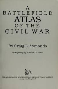
Symonds Craig L. Cartography by William J. Clipson
A Battlefield Atlas of the Civil War
Annapolis MD: Nautical and Aviation Publ. 1983. First Edition. Hardcover. Very Good/Very Good. Size=7"x10". B/W Photos 42 Maps. full book description Nautical and Aviation Publ. Annapolis MD 1983. 1st Edition VG/VG Hard Cover w/Dust Jacket. Size=7"x10" 106pp. B/W Photos 42 Maps. 1" DJ top front edge tears2 owner bookplate ink owner name/date on front endpapers o.w. clean tight and bright. Rest of bo ok in Fine condition. ISBN 0933852401 U.S. Civil War; American Civil War; Battlefield Atlas; Battlefield Maps; Cartography; Civil War Maps; Civil War History; Military History SELLING WORLDWIDE SINCE 1987. WE ALWAYS PACK WITH GREAT CARE! Nautical and Aviation Publ. hardcover
Bookseller reference : CONROY266627I ISBN : 0933852401 9780933852402
|
|
|
Symonds Craig L./Clipson William J. cartography
A Battlefield Atlas of the Civil War
Annapolis: Nautical & Aviation Publishing Co. 1983. 1st printing. VG/VG dust jacket price clipped dust jacket. xvi 106 p. frontis photos maps large 8vo; Nautical & Aviation Publishing Co. hardcover
Bookseller reference : 66338 ISBN : 0933852401 9780933852402

|
|
|
SYMONDS Craig L. and cartography by William J. Clipson
A Battlefield Atlas of the American Revolution
Mount Pleasant South Carolina: The Nautical & Aviation Publishing Company of America Inc 2001. Hardcover. Fine/Fine. Book club edition. Fine in fine dustwrapper. The Nautical & Aviation Publishing Company of America, Inc hardcover
Bookseller reference : 391332 ISBN : 0933852533 9780933852532

|
|
|
Symonds Craig L
A Battlefield Atlas of the Civil War
Annapolis Maryland: The Nautical and Aviation Publishing Company of America 1983. 7" wide by 10" tall. Bright clean square tight copy. No underlining. No highlighting. No margin notes. Pages are fresh and crisp. Bound in the original red boards lettered in gold on the spine and front cover. Gilt lettering is still bright and shiny. Illustrated throughout with vintage portraits and photos and 43 two-color full-page maps. The text accompanying each map enables the reader to relive the action of battle and sense the drama it held for the troops that fought. Introduction. Suggestions for Further Reading. First Printing of the First Edition. Hard Cover. Fine condition./VG DJ short closed tears. Illus. by Clipson William J. cartography. xv 106pp. . The Nautical and Aviation Publishing Company of America Hardcover
Bookseller reference : 003536 ISBN : 0933852401 9780933852402
|
|
|
Symonds Craig L. Cartography by William J. Clipson
A Battlefield Atlas of the Civil War
Annapolis MD: Nautical & Aviation Pub'g. 1983. First Edition. Hardcover. Fine/Very Good. Size=Large 8vo. B/W Photos & Maps. full book description Nautical & Aviation Pub'g. Annapolis MD 1983. 1st Edition Fine-/VG Hard Cover w/Dust Jacket. Size=Large 8vo 106pgsBiblio. B/W Photos & Maps. 1/2" DJ tear at bottom rear edge o.w. clean bright & tight. No ink names etc. Military History SELLING WORLDWIDE SINCE 1987. WE ALWAYS PACK WITH GREAT CARE! Nautical & Aviation Pub'g. hardcover
Bookseller reference : CONROY030887I
|
|
|
Symonds Craig L.; cartography by William J. Clipson
BATTLEFIELD ATLAS Of the Civil War
Annapolis MD: Nautical and Aviation Publishing Co. G/G. 1983. . Leatherette w/DJ. Sm 4to. 106 pp. DJ rubbedfrayed toned tears cover edges rubbed . Nautical and Aviation Publishing Co. hardcover
Bookseller reference : BOOKS287977 ISBN : 0933852401 9780933852402
|
|
 Receive by email
 Download as PDF document
 RSS feed


