|
Wauwermans, Lieutenant-General
Histoire de L'Ecole Cartographique Belge et Anversoise du XVIe siecle. Amsterdam, Meridian Publishing Co, 1964. 2 vols.
2 vols. 402,470 pp. 15 plts. Soft cover.*Reprint of the 1895 edition, fine condition.

|
|
|
Wauwermans, Lieutenant-General
Histoire de L'Ecole Cartographique Belge et Anversoise du XVIe siecle. Amsterdam, Meridian Publishing Co, 1964. 2 vols.
Amst., 1964, ,
Bookseller reference : 26107
|
|
|
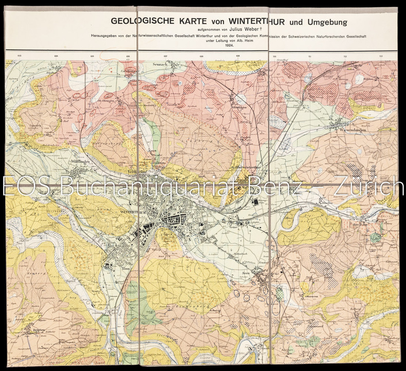
Weber, Julius
Geologische Karte von Winterthur und Umgebung.
Winterthur, 1924. Farbige Karte auf Leinen aufgezogen. 59 x 87 cm. + Wichtig: Für unsere Kunden in der EU erfolgt der Versand alle 14 Tage verzollt ab Deutschland / Postbank-Konto in Deutschland vorhanden +, A|B [2 Warenabbildungen]
Bookseller reference : 1802AG

|
|
|
Weber, Julius:
Geologische Karte von Winterthur und Umgebung.
Winterthur, 1924. Farbige Karte auf Leinen aufgezogen. 59 x 87 cm.
Bookseller reference : 1802AG
|
|
|
Weber,Hans
Sud Italia. Basilicata, Calabria, Campania, Puglia.
<br/> TITOLO: Sud Italia. Basilicata, Calabria, Campania, Puglia. <br/> AUTORE: Weber,Hans<br/> CURATORE: Testo di Heinz - Joachim Fischer. Traduz.di Ingeborg Babitsch.<br/> EDITORE: Cantini Ed.<br/> DATA ED.: 1989,<br/> EAN: 9788877370914
|
|
|
WEDEKIN BEATE, sous la direction D'ANGELIKA TASCHEN
Intérieurs New Yorkais.
1997 Taschen 1997, 299 pages, grand in 4 reliure cartonnée toilée bleue en très bon état avec jaquette en état d'usage (petite usures).
Bookseller reference : 14410
|
|
|
Wegener Alfred
LA FORMAZIONE DEI CONTINENTI E DEGLI OCEANI.
(Codice OS/0037) In 8° 320 pp., 63 figurei. Prima edizione. Data e firma. Brossura editoriale, ottimo stato. ~~~ SPEDIZIONE IN ITALIA SEMPRE TRACCIATA

|
|
|
Weigel Christoph
Vindelicia Rheti et Noricum
30,5 x 38,5 cm. Incisione in rame a pieni margini, con acquarellatura d'epoca. Piccolo cartiglio sulla sinistra, rappresentante un ritrovamento archeologico di una lapide con inciso il titolo della carta ed la firma dell'autore sorro. A fianco quattro monete romane. Qualche fioritura, piccole abrasioni alla piega naturale della carta.

|
|
|
WEIGEL Johann Christoph (1661 - 1726)
AUSTRIA inferior Secundum IIII. Quadrantes & regiones contiguas excudente Christophoro Weigelio
CARTA GEOGRAFICA di cm. 34,8x28,2 al filo della lastra, incisa in rame su forte carta pregiata di cm. 45,3x36,7 e colorata a amano all'epoca, proveniente da Atlante (probabilm. "Atlas Portatilis, Oder Compendieuse Vorstellung Der gantzen Welt: in einer kleinen Cosmographie, 1723) in cui era rilegata mediante brachetta alla piega. Uno dei primi atlanti scolastici, utile anche ai viaggiatori. WEIGEL, incisore su rame, mercante d'arte ed editore (cfr de.wikipedia).Perfettamente conservata.
|
|
|
WEIGEL Johann Christoph (1661 - 1726)
BELGIUM Regium accuratissime descriptum cum permutationibus cursus publici curante Christophoro Weigelio Noribergae
CARTA GEOGRAFICA di cm. 39x34,4 al filo della lastra, incisa in rame su forte carta pregiata di cm. 44x36,7 e COLORATA a mano all'epoca, proveniente da Atlante (probabilm. "Atlas Portatilis, Oder Compendieuse Vorstellung Der gantzen Welt: in einer kleinen Cosmographie, 1723) in cui era rilegata mediante brachetta alla piega. Uno dei primi atlanti scolastici, utile anche ai viaggiatori. WEIGEL, incisore su rame, mercante d'arte ed editore (cfr de.wikipedia). Salvo una fessura di 5 cm.al bordo inferiore della piega, è perfettamente conservata.
|
|
|
WEIGEL Johann Christoph (1661 - 1726)
HOLSATIAE, DITHMARSIAE, STORMARIAE et VAGRIAE Ducatus. Autore Christ: Weigel Norimbergae. [Schleswig-Holstein, Dithmarschen, Stormarn, foce dell'Elba...].
CARTA GEOGRAFICA di cm. 39,4X33,2 al filo della lastra, incisa in rame su forte carta pregiata di cm. 45x37 e COLORATA a mano all'epoca, proveniente da Atlante (probabilm. "Atlas Portatilis, Oder Compendieuse Vorstellung Der gantzen Welt: in einer kleinen Cosmographie, 1723) in cui era rilegata mediante brachetta alla piega. Uno dei primi atlanti scolastici, utile anche ai viaggiatori. Kiel Lubeck Hamburg, Bad Segeberg, la regione Eckernförde-Travemünde-Lüneburg-Elbemündung. WEIGEL, incisore su rame, mercante d'arte ed editore (cfr de.wikipedia). Salvo una fessura di 5 cm.al bordo inferiore della piega, è perfettamente conservata.

|
|
|
Weiland, C. F
Koenigl. Preuss. Prov. Schlesien. Entworfen und gezeichnet von C. F. Weiland.
Weimar, Geograph. Inst. 1846. Grenzkolor. Stahlst., 41 x 56 cm, mit Maßstäben u. statist. Übersicht sowie einer Nebenkarte. Breitrandig. Mittelfaltung. W. Rand mit Knick- u. Knitterspuren. Randläs. tlw. hinterlegt. Mittelfalz mit kl. hinterlegten Rissen. Zwei kl. Ecken fehlen. Papierbed. schwach gebr. Schönes Kartenbild. Nebekarte: Die nächste Umgebung von Breslau. Die Statistik zeigt die Einteilung der Provinz in Regierungs-Bezirke.
Bookseller reference : KART0046

|
|
|
WEISS (Helmut) DUNCKER (Dieter R.)
duche de Brabant en cartes et gravures anciennes.
Couverture reliee sous jaquette, 160 pages, 39 x31 cm, ** tres bon etat ( neuf !!! ). ISBN 9782801104767. reproductions de cartes et gravures en couleurs et en noir et blanc, legendes en francais, anglais et allemand, captions in French, English and German, Beschriftung im Franzosisch, Englisch und Deutsch

|
|
|
WEISS (Helmut) DUNCKER (Dieter R.)
duche de Brabant en cartes et gravures anciennes.
Hardcover, 160 pages, Texte en Francais, 385 x 305 mm, Tres belle exemplaire !!. ISBN 9782801104767. reproductions de cartes et gravures en couleurs et en noir et blanc, legendes en francais, anglais et allemand, captions in French, English and German, Beschriftung im Franzosisch, Englisch und Deutsch

|
|
|
WEISS (Helmut) DUNCKER (Dieter R.)
duche de Brabant en cartes et gravures anciennes.
, Duculot / Mappamundi,1983 Gembloux / Knokke, Belgique, 1983., Couverture reliee sous jaquette, 160 pages, 39 x31 cm, ** tres bon etat ( neuf !!! ). ISBN 9782801104767.
Bookseller reference : 52071
|
|
|
WEISS (Helmut) DUNCKER (Dieter R.)
duche de Brabant en cartes et gravures anciennes.
Gembloux / Knokke, Duculot / Mappamundi,1983, 1983 Hardcover, 160 pages, Texte en Francais, 385 x 305 mm, Tres belle exemplaire !!. ISBN 9782801104767.
Bookseller reference : 55288
|
|
|
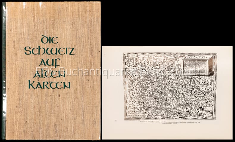
Weisz, Leo
Die Schweiz auf alten Karten. Mit Geleitwort und einem kartographisch-technischen Anhang von Prof. Ed. Imhof.
Zürich, NZZ, 1969. 4°. 247 S. Mit zahlr. (dv. viele gef.) Karten u. Textillustr. nach alten Vorlagen. Orig.-Halblederband. + Wichtig: Für unsere Kunden in der EU erfolgt der Versand alle 14 Tage verzollt ab Deutschland / Postbank-Konto in Deutschland vorhanden +, A 2. Auflage.
Bookseller reference : 4008CB

|
|
|
WEISZ, Leo:
Die Schweiz auf alten Karten. Mit Geleitwort und einem kartographisch - technischen Anhang von Ed. Imhof.
Zürich, Verlag der Neue Zürcher Zeitung, 1945, in-4to, 227 S. + 4 n.numm. S., mit Textabb. u. 244 z.T. gefalt. Kartenabb., Widmung vom Vorbesitzer auf Vorsatz, Original H.-Leinenband, (erste Ausgabe).
Bookseller reference : 128731aaf
|
|
|
WEISZ, Leo:
Die Schweiz auf alten Karten. Mit Geleitwort und einem kartographisch - technischen Anhang von Ed. Imhof.
Zürich, Verlag der Neue Zürcher Zeitung, 1945, in-4to, 227 S. + 4 n.numm. S., mit Textabb. u. 244 z.T. gefalt. Kartenabb., Original H.-Leinenband, Orig. ill. Umschlag. (Erste Ausgabe).
Bookseller reference : 130316aaf
|
|
|
Weisz, Leo:
Die Schweiz auf alten Karten. Mit Geleitwort und einem kartographisch-technischen Anhang von Prof. Ed. Imhof.
2. Auflage. Zürich, NZZ, 1969. 4°. 247 S. Mit zahlr. (dv. viele gef.) Karten u. Textillustr. nach alten Vorlagen. Orig.-Halblederband.
Bookseller reference : 4008CB
|
|
|
WELLENS-de-DONDER
Philippe Vandermaelen (1795-1869).
Bruxelles, Bibliothèque Royale Albert 1er, 1969. 15 x 23, 63 pp., 4 planches en N/B, 6 figures, broché, très bon état.
Bookseller reference : 94211
|
|
|
Wellington John H
South West Africa and Its Human Issues
Oxford at The Clarendon Press London 1967. First Edition. Hardcover Original Cloth. Very Good Condition/Good. Illustrator: Maps. Preface by Author Acknowledgements Introduction: The Clash of Interests list of plates at the rear of the book four appendices and index. The text is illustrated with a black-and-white photographic frontispiece showing The Ruacana Falls on the Kunene River figures tables maps and at the rear of the book a four page fold out map showing south west Africa and the already mentioned black-and-white plates. Navy blue cloth covered boards with gilt coloured titles to the back strip. Plain text dustwrapper with ochre coloured titles to the front panel and back strip. "This book attempts to assemble the primary facts bearing on the present South West African situation. The result of more than forty years of intensive study of the political economic and racial conditions of Southern Africa it presents the human issues of the mandated territory from three angles: the geographical the historical and the political." -- from front fold over panel blurb. Rubbing to the book corners and lower book edges. Very light age toning of the text block edges and pages. Previous owner's name to the top edge of the front paste-down. Chipping with loss to the dustwrapper corners and back strip corners. There is a small piece missing from the lower right hand corner of the rear panel. Sunning to the back strip along with a blue coloured stains. The results of insect activity can be seen to the front dustwrapper panel and the edges show a little creasing and small closed tears. Sunning to the verso along with the aforementioned blue coloured stain. Size: 8vo - over 7�" - 9�" tall. 7 VIII - XXIV 1 461 19 � of which 13 are black-and-white photographs pages. Please refer to accompanying picture s. Illustrator: Maps. Quantity Available: 1. Category: Politics & Government; Geography; South West Africa; Sociology & Culture. Inventory No: 0121475. . THIS BOOK WEIGHS OVER 1KG WITHOUT PACKING AND EXTRA POST WILL BE REQUIRED FOR SHIPMENT OUTSIDE AUSTRALIA. PLEASE ENQUIRE FOR COSTS BEFORE YOU ORDER THANK YOU. Oxford at The Clarendon Press hardcover
Bookseller reference : 0121475

|
|
|
WH. Smith & Sons W. H.
PLAN OF LONDON With INDEX
Edinburgh: John Bartholomew & Co. 1880. ND 1880 The Royal Horticultural Society Gardens in Kensington are still mapped but closed in 1882 being the Royal Albert Hall and Royal College of Music so this scarce map is published prior to that date. 23.5 x 33 x 23.5 inches 80x60 cms Folded and enclosed with a green cloth booklet 31pp with index of the streets etc. A nice copy with a few pin-holes where the folds intersect. A single un-dissected sheet pasted on linen with 36 panels when folded. From Hampstead to south of Battersea and Shepherd's Bush to Greenwich with printed and hand-colouring. The map has grid-lines each covering half mile suares with grid letters and numbers in the margins. Tower Bridge is not present. 1st Edition. Hardback. Fine. Folio. John Bartholomew & Co. Hardcover
Bookseller reference : GT058
|
|
|
Wheat James Clement; & Christian F. Brun
Maps and Charts Published in America before 1800 A Bibliography : Second Revised Edition
London: The Holland Press 1985. Fine condition in a Fine dust jacket. NO chips. NO tears. NO creases. NO rubbing. NO fading. Protected by a removable Brodart clear-plastic sleeve. Bright shiny clean and square. Sharp corners. NO owner's name or bookplate. NO remainder mark. Crisp and unmarked. 1985 Second Revised Edition. Expertly describes all separately published maps and charts in America until 1800 as well as those in books pamphlets almanacs magazines atlases and gazetteers. Illustrated with 18 plates 1 folding. Bound in the original gilt-stamped green boards. Complete with dust jacket. Second Revised Edition. Hardcover. Fine condition/Fine dust jacket. xxiv 215pp. 18 plates . Great Packaging Fast Shipping. The Holland Press Hardcover
Bookseller reference : 018080 ISBN : 0900470895 9780900470899
|
|
|
WHEAT J. C. - BRUN C.F.
Maps and Charts published in America before 1800. A bibliography. Second revised edition.
In 8°, t.t. edit. con sovracc. ill., pp. XXIV,215,(3), con numerose riprod. di carte in tavv. f.t.,copia molto buona. (L026/d) (la spedizione standard è SEMPRE tracciata con raccomandata-piego di libri, eventuale fattura da richiedere all'ordine)
|
|
|
Whipple Gertrude and Preston E. James cartography by Arthur HRobinson Asst. Professor of Geography Univ of Wisconsin H. Ro
Our Earth
NY: Macmillan. G ex-school library copy. 1947. Red binding yellow lettering. Geography textbook as used in classrooms in the 1940s. . Some tanning to edges of endpapers school stamp and pocket. . Macmillan unknown
Bookseller reference : BOOKS050136I
|
|
|
WHITAKER (Harold)
The Harold Whitaker Collection of County Atlases, Road-Books & Maps Presented to the University of Leeds.
First Edition, 4to, frontis., facsimiles, orig. cloth.
|
|
|
WHITAKER Harold
The Harold Whitaker Collection of County Atlases, Road-Books & Maps presented to the University of Leeds. A Catalogue.
4to., SOLE EDITION, with a frontispiece and 9 plates of facsimiles; cloth, covers a little sunned and age-marked, backstrip faded else a very good, clean copy of a scarce work. This outstanding catalogue (compiled by Whitaker of his own collection) was published by the Brotherton Library as 'Library Publications' No. 2. It was never reprinted and is now increasingly hard to find. Sold from an institution with its small, neat stamp on front free endpaper, half-title and title only

|
|
|
Whitbread J.
WHITBREAD'S NEW PLAN OF LONDON
London: J. Whitbread 142 Oxford Street 1864. ND 186426x18 inches. Folding plan with hand-colouring. Linen backed. Green blind-stamped patterned case with gilt stamped titles. Enclosed loosely the 43pp index booklet listing reference to15800 streets squares postal districts. car fares & c. Also listing the principal exhibitmusement. The lower right margin announces that the plan is now also available extended down to Crystal Palace. Hardback. Fine. Folding map. Printed Map. J. Whitbread, 142 Oxford Street Hardcover
Bookseller reference : Map878
|
|
|
Whitefield Peter
MAPPING THE WORLD
London: The Folio Society 2000. 263pp. Illustrated in black & white & colour colour plates with maps with photographs index bibliography. A fine copy unread with no wear fading or marks. Attractive map decorated slip-case. 1st Folio edition 1st Impression. hard back. Fine/Slipcase. 4to. The Folio Society hardcover
Bookseller reference : S241
|
|
|
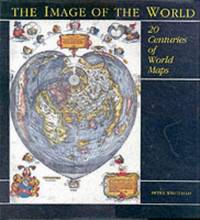
Whitfield Peter
The Image of the World : 20 Centuries of World Maps
San Francisco: Pomegranate Artbooks 1994. Near Fine condition in a Near Fine dust jacket only slightly rubbed at the corners. NO chips. NO tears. NOT price clipped $29.95. Bright shiny clean square and tight. Sharp corners. Hinges are perfect. NOT a library discard. NO owner's name or bookplate. NO remainder mark. Pages are fresh and crisp. NO underlining. NO highlighting. NO margin notes. Lavishly illustrated with full-page and double-page plates -- nearly all in beautiful color. Examines the history of world mapmaking through 70 outstanding individual examples discussing the maps and their makers in relation to their age. Published in association with The British Library. Includes: Preface; Introduction; Classical Foundations; The Religious Imagination; The Play of the Intellect; The Theatre of the World; Science and Communication. Further reading list. Index of Names. Index of Subjects. Bound in the original black boards lettered in shiny gold on the spine. From the dust jacket: "From Bishop Isidore's simplistic T-O design for a world map through the elaborately decorated manuscript maps and printed maps of the 17th and 18th centuries which are works of art in themselves to scientific maps showing the ocean floor Peter Whitfield examines the history of world mapmaking through 70 outstanding individual examples discussing the maps and their makers in relation to their age and placing them within the context of the wider history of ideas. Drawing on the wide variety of maps held by The British Library and other major collections throughout the world THE IMAGE OF THE WORLD is superbly illustrated throughout in colour." Oversize Hardcover. 10.5" wide by 11.5" tall. This large heavy book will require extra postage for Priority and International shipments but only the standard charge for media mail. First U.S. Edition. Oversize Hardcover. Near Fine condition/Near Fine dust jacket. Illus. by Mitchell John jacket design. viii 144pp. Pomegranate Artbooks Hardcover
Bookseller reference : 008488 ISBN : 0876540809 9780876540800
|
|
|
Whitfield (Peter)
Mapping the World. A History of exploration.
Folio Society, Londres, 2000. Un volume in-4 reliure de l'éditeur sous étui cartonné illustré, 263 pages, texte en anglais, riche iconographie en couleurs. Parfait état.
Bookseller reference : 4856
|
|
|
WHITFIELD Peter
The Charting of the Oceans. Ten Centuries of Maritime Maps. FINE COPY IN UNCLIPPED DUSTWRAPPER
Roy 4to., First Edition, with numerous fine coloured reproductions and pictorial endpapers; blue cloth, gilt back, a fine copy in unclipped dustwrapper.

|
|
|
WHITFIELD PETER -
The Charting of the oceans. Ten centuries of maritime maps.
London, The British Library, 1996, 4to quadrato (cm. 27 x 29) tutta tela editoriale con sovraccopertina illustrata a colori, pp. 136 con numerosissime illustrazioni in nero e a colori nel testo. Stato di nuovo.

|
|
|
WHITFIELD PETER -
The Charting of the oceans. Ten centuries of maritime maps.
London, The British Library, 1996, 4to quadrato (cm. 27 x 29) tutta tela editoriale con sovraccopertina illustrata a colori, pp. 136 con numerosissime illustrazioni in nero e a colori nel testo. Stato di nuovo.

|
|
|
WHITFIELD Peter -
The Charting of the oceans. Ten centuries of maritime maps.
London, The British Library, 1996, 4to quadrato (cm. 27 x 29) tutta tela editoriale con sovraccopertina illustrata a colori, pp. 136 con numerosissime illustrazioni in nero e a colori nel testo. Stato di nuovo.

|
|
|
Whiting, J.R.S
Handful of History
, Alan Sutton, 1978 softcover, 201 pages, illustr. b/w. ISBN 0904387216.
Bookseller reference : 62430
|
|
|
WICHURA, A.:
Das militärische Planzeichnen und die Militär-Kartographie. Ein Handbuch für Officiere. (ERSTAUSGABE).
Berlin, Ernst Siegfried Mittler, 1872, in-8vo, 2 Bl. + 86 S. + 2 lith. Figurentafeln, Bibl.-Stempel und hs. Bibl.-Nr. auf Titelbl., Leinenband, vergold. Titel und Bibl.-Nr. auf dem Rücken.
Bookseller reference : 59489aaf
|
|
|
Wiebeking Carl Friedrich von; Eckard, Johann Christian
Hydrographisch und militairische Karte von dem Nieder Rhein von Lintz bis unter Arnheim in X Blatt ; Sr: Hocfurstl :Durchlaucht dem Landgrafen von Hessen Darmstadt
Serie di 9 (su 10) incisioni all'acquaforte di mm 670 x 340 alla battuta su carta di gran corpo. Tutti i foglio a grandi margini in perfetto stato di conserazione. Carta in scala 1:30 000. Magnifica e molto rara opera cartografica sul Corso del Reno, purtroppo mancante dell'ottavo (8) foglio.
|
|
|
Wiggers, Hinke & Glerum, Huub
Speelkaarten Holland Casino
, Holland Casino, Ringband; COMPLEET; Inclusief kaartspel en losse bijlage met vertaling in Engels en Duits.
Bookseller reference : 62446
|
|
|
Wigram The Rev. Joseph C.
THE GEOGRAPHY OF THE HOLY LAND;
London: Thomas Varty 1850. with an account of its ancient people and Kingdoms; their tribes; the journeyings of Our Lord; and the Modern Condition of Palestine.ND c1850 95pp 1 folding map outline hand-coloured 1 folding plan orig. blind stamped cloth gilt lettering front joint frayed and worn otherwise a nice copy. . 4th edition. hard back. V.g. 12mo. Thomas Varty hardcover
Bookseller reference : C439
|
|
|
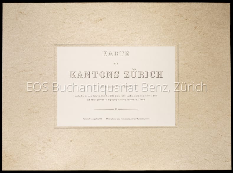
Wild, Johannes
Karte des Kantons Zürich im Masstab von 1:25000 nach den in den Jahren 1843 bis 1851 gemachten Aufnahmen von 1825 bis 1865 auf Stein gravirt im topographischen Bureau in Zürich.
Zürich, Meliorations- und Vermessungsamt, 1990. 4°-quer. Titelblatt, Ueberischt und 30 faksimilierte, farbige Kartenblätter. 16 Seiten Dokumentation zur Faksimilierung. Orig. Pappschachtel mit Deckelschild. + Wichtig: Für unsere Kunden in der EU erfolgt der Versand alle 14 Tage verzollt ab Deutschland / Postbank-Konto in Deutschland vorhanden +, A|B [2 Warenabbildungen]
Bookseller reference : 1904CB

|
|
|
Wild, Johannes:
Karte des Kantons Zürich im Masstab von 1:25000 nach den in den Jahren 1843 bis 1851 gemachten Aufnahmen von 1825 bis 1865 auf Stein gravirt im topographischen Bureau in Zürich.
Zürich, Meliorations- und Vermessungsamt, 1990. 4°-quer. Titelblatt, Ueberischt und 30 faksimilierte, farbige Kartenblätter. 16 Seiten Dokumentation zur Faksimilierung. Orig. Pappschachtel mit Deckelschild.
Bookseller reference : 1904CB
|
|
|
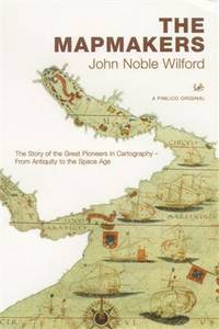
Wilford John Noble
The Mapmakers : The Story of the Great Pioneers in Cartography - From Antiquity to the Space Age
London: Plimlico 2002. 508pp. Unread copy. Pictorial card wrappers. Illustrated throughout. 1st Uk paperback. paperback. Mint. large 8vo. Plimlico Paperback
Bookseller reference : S237 ISBN : 0712668128 9780712668125
|
|
|
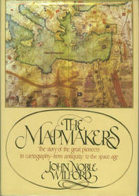
Wilford John Noble
The Mapmakers
New York: Alfred A. Knopf. Hardcover. 1981. 1st Edition. 8vo 414pp . Fine in Fine DJ. B&W Illustrations. The story of the great pioneers in cartography from antiquity to the space age . Alfred A. Knopf hardcover
Bookseller reference : 002787 ISBN : 0394461940 9780394461946
|
|
|
Wilford, John Noble.
MAPMAKERS.
414p. Numerous illustrations. 8vo. Original printed wraps. **PRICE JUST REDUCED! REF4
|
|
|
WILHELM GREVE, (Map maker).; OSCAR FÜRSTENAU, (1826-1863), (Lithographer).
[LARGE COLLECTION OF MILITARY MAPS AND PLANS OF PRUSSIA] 53 Preussische Karten. [i.e. 53 Prussian maps].
Very Good German Original color lithograph maps in 7 special cloth cases. Cases large 8vo., only seventh one is smaller which is covered by European marbling. Bookseller and bibliothek stamps on some maps, plans and sketches; and cases interior. A fine map collection. Contents: V.1: Includes 1 map, 2 plans and 5 skecthes, 1 uebersichtskarte. Uebersichtskarte für die Geschichte des Iten und IIten schlesisschen Krieges von 1740-1745. Kriege Friedrichs des Grossen. 1/740000. 73x81 cm.; Plan zur Erstürmung von Glogam am 9 Marz 1741 (Entworfen nach alten Planen). 1/6250 / 1/100000. 48x52 cm; Plan der Schlach bei Mollwitz am 10 April 1741. 1/25000. 43x59 cm.; (Skizze) Stellung der preussischen und oesterreichischen Truppenam, 3 Januar 1741. 1/740000. 30x30 cm.; Skizze zum Scharmützel bei Ellguth und zum Gefecht bei Ottomachall am 9. Januar 1741. 1/67500. 34x26 cm.; Skizze zu den Winterquartieren des preussen mit Stellung der Truppen am 20 Februar 1741. 1/740000. 46x52 cm.; Skizze zum Ueberfall bei Baumgarten am 27 Feb. 1741. 1/50000. 29x34 cm.; Marsch der oesterreichischen Armee unter F. M. Neipperg und der preussischen Truppen unter dem Könige von der Schlacht bei Mollwitz. 1/1480000. 36x42 cm.; [.] Standorte des preussischen Heeres bei Ausbruch des Krieges 1740. 1/2400000. 34x55 cm.; V.2: 12 pieces: 3 uebersichtskarten, 2 planen, 7 skizzen. ... von Europa im Jahre 1756. 1/18000000. 33x46 cm.; ... des südöstlichen Kriegsschauplatzes. 1/740000. 65x95 cm.; Standorte des preussischen uns sachsischen Heeres und Stellung des oestreichischen Truppen in Böhmen, Mahren, oestrç Schlesen und Erzth. oesterreich var Beginn des siebenjahrigen Krieges. 1/2200000. 56x72 cm.; Plan der Schlacht bei Lobositz am 1. Oktober 1756. Verlauf des Schlact bis etwa 12 Uhr Mittags. 1/25000. 47x60cm (Also includes Plan der 2ten Attacke des preussischen Kavallerie and Skizze des beiderseitigen Vormarsches am 30ten September 1756).; ... Weiterer Verlaufdes Schlact bis etwa 3 Uhr Nachtmittags. 1/25000. 47x60 cm.; Skizzen: 1. Vormarssch 28. 8 bis 10.9.56. 2.-3. Pirna 1.10.56. 4. Bewegungen Schwerins 56. 5. Pirna 10.10.56. 6. Pirna 12.10.56. 7. Pirna 13.10.56. V.3: 5 skizzen (No: 8-12) und 3 plannen (No: 3, 4-A, 4-B). Plan 4-A-4-B: Prag, 6.5.1757.; Plan 3: Reichenberg, 21.4.57. Skizze 8: Postrungen und Winterquartiere Dezember 56 (Huge size).; Versammlung der Heere, Marz und April 57.; Einmarsch bis 30.4.57.; Stellungen am 1.5.57.; Stellungen am 5.5.57. V.4: Karten 1,2,3,5 (4 is missing); skies 31,32; uebersichtskarte 5; Plan 12-B. ... des nordöstlischen Kriegsschauplatzes (Huge size).; Skizze 31: Heeresbewegungen vom 11.11.57 bs zum Einrücken in die Winterquartiere, Winter 1757-58.; (World War 1): Karte 1: Belgien und nordost-frankreich. Ostpreussen, polen, kurland, Weissrussland.; Galizien und Wolkynien.; Kleinasien , Schweizes Meer, Kaukasien, Kurdistan, Armenien, Aserbeidschan, Arabier, Mittellandisches Meer: Vordasien map. V.5: Sizzen 20-24 - Planen 6-A, 6-B - 9. Planen: Gr. Jagersdorf, 30.8.57.; Jager b. Goerlitz, 31.8.-9.9.57. Moys, 7.9.57.; Breslau, 22.11.57.; Schweidnitz, 24.10-12.11.57.; Skizze 20: Feldzung in ostpreussen Vormarsch des russischen Heeres bis 6.7.57.; 21: Heeresbewegungen vom 6.7.57 bis zur Schlact bei Gr. Jagersdorf. 22: ... nach der Schlact bei Gr.-Jagersdorf bis zum Schluss.; 23: Bewegungen i. d. Lausitz u. i. Schleisen, 20.8.-30.11.57.; 24: Lager bei Liegnitz, 19.-27.9.57. V.6: Plan 5-A, 5-B - Skizzen no: 13-19. Plans: Kolin, 18.6.57.; Kolin, 18.6.57.; Skizzen 13: Beiderseitige Stellungen 8.5.57.; 14: Operationen Beverns u. d. Königs gegen Daun 10.5.-17.6.57.; Bewegungen vom 20.6.-1.7.57. Stellungen vom 1.7.57.; Rechten Elbufer in der ersten Halfte des Juli 1757.; ... vor Zittau, 12.-20.8.57. V.7: 4 plans in cloth covered with European marbling. These last 4 plans from "Suworow und Polens untergang. Nach archivalischen Quellen dargestellt" von Friedrich von Smitt, 1858 First Edition. Pl. 1: Der Schlact am Rymnik den 11/22 Septeember 1789. Pl. 2: ... der
|
|
|
WILKES (J.).
Cumberland.
London, 1802, mapa grabado en cobre, suavemente coloreado a mano, de 23'5 x 19 cm.
|
|
|
Wilkie, Richard W. ; Tager, Jack [Ed.]
Historical Atlas of Massachusetts
31.5x41 cm. 152 pages. Hardcover with dust jacket. Cover corners slightly rubbed. Else in good condition. PLEASE NOTE: This item is overweight. We may ask for extra shipping costs.
|
|
|
WILLIAM FRANKLIN [FRANCKLIN], (18th-19th century).
[RARE TROJAN MAP] Bemerkungen über die Ebene von Troja.; Uebersicht der neuesten geographischen Veranderungen in den Jahren 1799 und 1800 (Allgemeine Geographische Ephemeriden VII. Bds. erstes Stick. Januar 1801).
Very Good German Modern soft cover. Cr. 8vo. (20 x 12 cm). In German. 114 p., 1 folded map of Troia (Ebene von Troja) and one folded table (Statistische Tabelle auf das Jahr 1800). (Books is probably missing, because text is not completed on 114th page). Franklin's article pp. 25-64. Map of Troia (Charte von der Ebene von Troja) oblong 19x24 cm. Bemerkungen über die Ebene von Troja.; Uebersicht der neuesten geographischen Veranderungen in den Jahren 1799 und 1800 (Allgemeine Geographische Ephemeriden VII. Bds. erstes Stick. Januar 1801). It's just for sale for its map and Franklin's 'Troy'. Franklin was captain in the East India Company's service. His article of 'Bemerkungen über die Ebene von Troja" [Remarks and observations on the plain of Troy] reflects the romantic spirit of Europe in its period, especially on Hellenism. This volume (seventh) of the serie (Allgemeine Geographische Ephemeriden) is rare and map which it includes rare as well. Could not be found any copy of this volume in OCLC.
|
|
 Receive by email
 Download as PDF document
 RSS feed


