|
TANNER HELEN HORNBECK editor with cartography by PINTHER MIKLOS
ATLAS OF GREAT LAKES INDIAN HISTORY
University of Oklahoma Press Norman 1987. 224 pp quarto sepia illustrations coloured maps very good copy in illustrated limp wrappers. With the bookplate of John Calaby inside front cover. University of Oklahoma Press, Norman, 1987 unknown
Bookseller reference : 228372
|
|
|
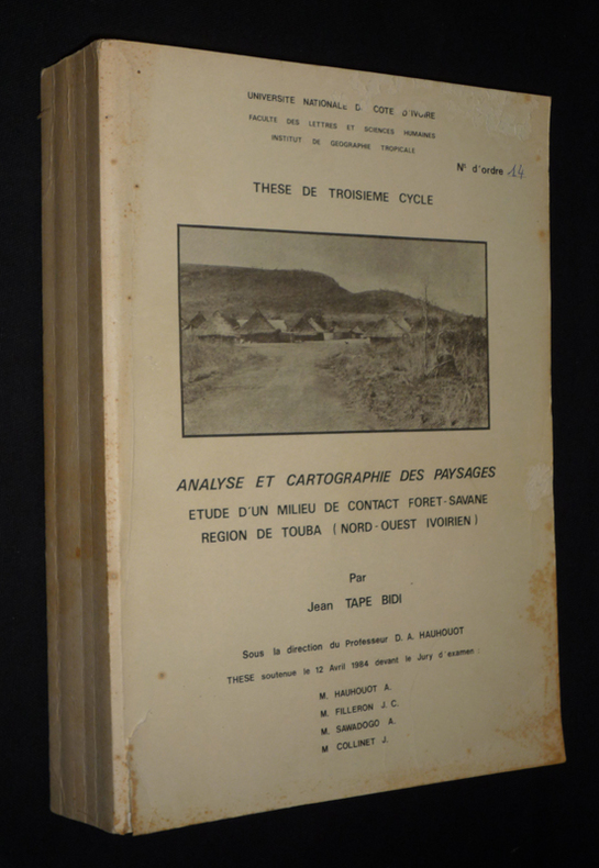
Tape Bidi Jean
Analyse et cartographie des paysages : Etude d'un milieu de contact forêt-savane, région de Touba (nord-ouest ivoirien)
Université Nationale de Côte d'Ivoire Dos carré collé 1984 In-4 (21 x 29 cm), dos carré collé, 458 pages, thèse de doctorat 3e cycle ; pliures au dos, quelques traces et rousseurs aux plats et tranches, déchirure sans manque et éraflures au premier plat, par ailleurs intérieur bien conservé, état moyen. Livraison a domicile (La Poste) ou en Mondial Relay sur simple demande.
Bookseller reference : xs2308
|
|
|
TARANTINO Angela (a cura di).
La Cartografia Europea tra il XVI ed il XVIII secolo Catalogo della Mostra. Palermo, Museo Archeologico Regionale, Novembre-Dicembre 1984
con 124 illustrazioni a colori, per lo più a tutta pagina. Note e bibliografie.
|
|
|
TARDIEU (Ambroise);
ATLAS pour servir à l'intelligence de l'Histoire Générale des Voyages de LAHARPE.
Ledoux Paris 1821 1 vol. In-folio de 2 ff.n.ch. 15 feuillets double (planches), demi-chagrin de l'époque, dos à nerfs orné.
Bookseller reference : 14946
|
|
|
TARDIEU, AMBROISE.
Carte de l'Ile d'Elbe.
Tratta da "Campagne de 1801", Tome 1. Incisione in rame all'acquaforte, 1820 circa, b/n, cm 27 x 41 circa (alla lastra), in rettangolo in alto a sinistra la Rade de Porto - Ferrajo. Ambroise Tradieu (1788 - 1841) cartografo del governo francese. Carta vergata priva di filigrana, margini irregolari e leggermente ingialliti, lievissimo foxing, inciso in buono stato di conservazione. .

|
|
|
Tardieu, Amédée
Senegambia e Guinea di Amedeo Tardieu. Nubia di S. Cherubini. Abissinia di Natale Desvergers
8°, 23 cm, pp. 407, (3); 140; 48; 2 carte geografiche più volte ripiegate e 39 tavole incise fuori testo, testo su due colonne, rilegatura coeva in mezza pelle, titolo in oro su tassello al dorso, piatti marmorizzati. Fa parte di: L'Universo o storia e descrizione di tutti i popoli ec, loro religioni, costumi usanze ec. Esemplare molto buono

|
|
|
Tardieu, Pierre Francois
Gouvernement d'Anjou. Grave par P. F. Tardieu. Ecrit par Dubuisson. [Kupferstich / copper engraving].
o.J.
Bookseller reference : 43564BB

|
|
|
Tardieu, Pierre Francois
Gouvernement de Berry. Grave par P. F. Tardieu. Ecrit par Dubuisson. [Kupferstich / copper engraving].
o.J.
Bookseller reference : 43566BB

|
|
|
Tardieu, Pierre Francois
Gouvernement de l'Orleanois. Grave par P. F. Tardieu. Ecrit par Dubuisson. [Kupferstich / copper engraving].
o.J.
Bookseller reference : 43563BB

|
|
|
Tardieu, Pierre Francois
Gouvernement de La Touraine. Grave par P. F. Tardieu. Ecrit par Dubuisson. [Kupferstich / copper engraving].
o.J.
Bookseller reference : 43561BB

|
|
|
Tardieu, Pierre Francois
Gouvernement de Nivernois. P. F. Tardieu scrip. Dubuisson sculp. [Kupferstich / copper engraving].
o.J.
Bookseller reference : 43562BB

|
|
|
Tardieu, Pierre Francois
Gouvernement du Bourbonnois. Grave par P. F. Tardieu. Ecrit par Dubuisson. [Kupferstich / copper engraving].
o.J.
Bookseller reference : 43559BB

|
|
|
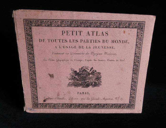
TARDIEU-DENESLE Madame
PETIT ATLAS DE TOUTES LES PARTIES DU MONDE, A L'USAGE DE LA JEUNESSE, Contenant les Découvertes des Voyageurs Modernes et l'Etat Géographique de l'Europe, d'après les derniers traités de Paix .
A Paris, Chez Tardieu-Denesle, 1820 ( 3e édition ), format oblong ( 218x265mm), cartonnage illustré de l'éditeur, 96 pages + 21 cartes colorées, certaines dépliantes, couverture un peu usagée et restauration ancienne au dos de l'ouvrage ( toile écrue), quelques traces d'usages des cartes, sinon l'ensemble est dans un état correct.
Bookseller reference : 9156
|
|
|
TARIDE
Nouvelle Carte de l'Afrique. Echelle 1/8.000.000
Collection des Cartes Taride, sans date Grande carte dressée par PELTIER, format 110 X 120, sous couverture.- Tirage en 6 couleurs.
Bookseller reference : 76839
|
|
|
TARIDE
Nouvelle Carte de l'Afrique. Echelle 1/8.000.000
Grande carte dressée par PELTIER, format 110 X 120, sous couverture.- Tirage en 6 couleurs. Très bon état général. [ARCH]
|
|
|
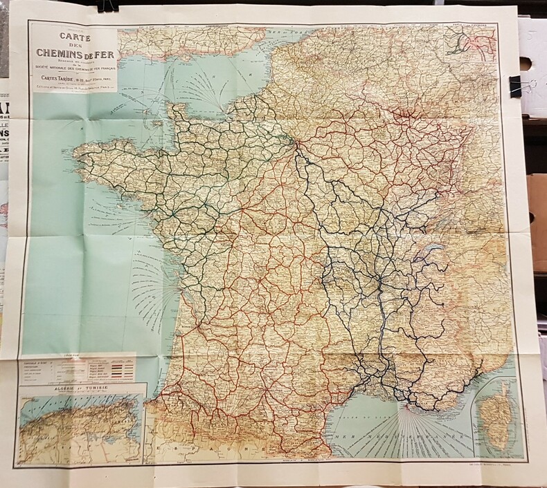
TARIDE. [CHEMINS DE FER].-
Carte des Chemins-de-fer.-
Réseaux en couleurs de la Société Nationale des Chemins-de-fer Français. Cartes Taride. Paris. Imprimerie Gaillac-Monrocq. s.d. Sans doute avant 1944. Très grande carte (120 x 110 cm) repliée 28 fois, coloris très vifs avec en plus des chemins de fer de la France continentale ceux de Algérie et Tunisie dans un cartouche de 28 x17cm et ceux de la Corse dans un cartouche de 10 x 17 cm. Bel exemplaire d'un bel effet décoratif.
Bookseller reference : ORD-10228
|
|
|
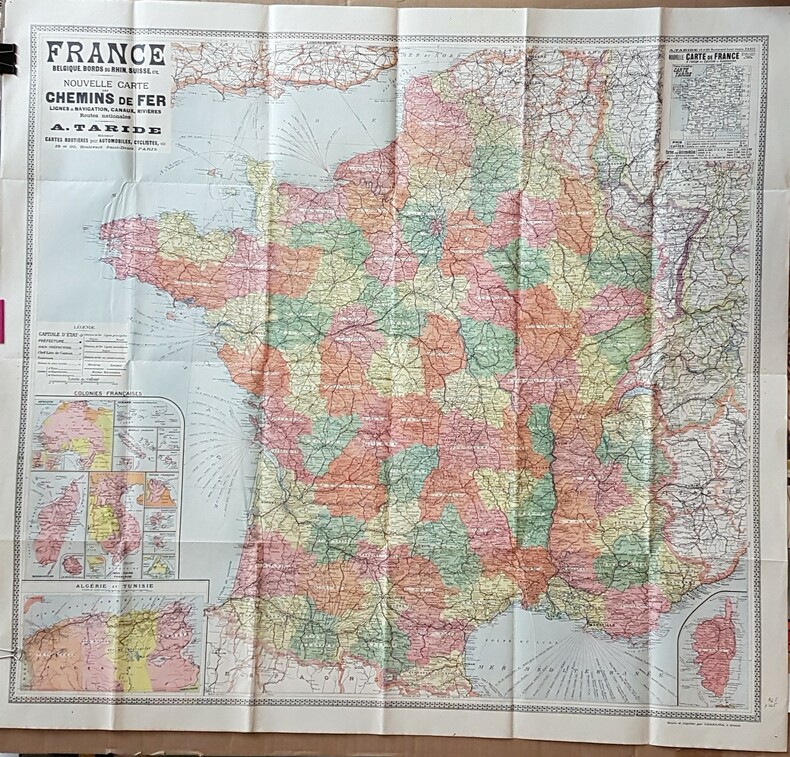
TARIDE. CHEMINS DE FER.-
FRANCE. Belgique, Bords du Rhin, Suisse, etc. Nouvelle carte des Chemins de Fer, Lignes de Navigation, Canaux, Rivières, Routes Nationales. Echelle 1/1150000.-
Gravée et imprimée par Charaire à Sceaux. Sans date, probablement autour de 1900. Grande carte en couleurs de 105 x 96,5 cm plusieurs fois repliée. Elle contient 3 cartouches, soit: Colonies françaises, Algérie et Tunisie et Corse. Les départements alsaciens sont toujours situés en Allemagne. Carte très décorative en très bon état.
Bookseller reference : ORD-17706
|
|
|
TASSIN (Christophe.)
Plans et profilz des principales villes de la province de Champagne, avec la carte générale & les particulières de chascun gouvernements d’icelles.
s. l. (Paris), , s. l. (Paris), (vers 1630) ; in-8 oblong, demi-basane rose, dos lisse orné de motifs dorés. (Reliure du XIXe siècle). Titre gravé dans un encadrement baroque de rocailles, table gravée, 51 planches numérotées pour ce titre auxquelles on a ajouté 15 autres gravures.Cartes des gouvernements, plans et vues des villes. Les plans de Champagne concernent les principales villes de l’actuelle Champagne, mais aussi les Ardennes et la Lorraine. Ay, Chaalons, Charleville, Chaumont, Clermont, Dormans, Espernay, Langres, Maubert Fontaine, Mery sur Seine, Meszière, Monteclair, Montigny le Roy, Mouzon, Ste Menehould, Troyes, Verdun, Villefranche, Virty le François. Pour chaque gouvernement, une carte de la région, chaque ville est ensuite représentée par un plan et une vue. La table annonce pour la planche 29 un plan de Maubert-Fontaine, elle a été remplacée ici par une vue de Dampierre non numérotée qui n’est pas annoncée dans la table. Les 15 cartes et vues ajoutées sont du même format, certaines, du XVIIe, de la même facture que l’album, semblent être également de Tassin, d’autres sont plus tardives, toutes montrent des vues et plans de villes de Champagne. Certaines planches, en particulier les figues ajoutées, ont été montés sur papier vergé par le relieur du XIXe siècle qui a aussi doublé un marge. De la bibliothèque de Louis Morin, typographe à Troyes (ex-libris du XIXe), ce dernier a noté sur la garde : “Il a été ajouté des vues et plans, ce qui (...) rend le présent recueil des plus intéressants”.
Bookseller reference : 46404471
|
|
|
Tavenier, R./ Ameryckx, J./ Snacken, F./ Faeasyn, D.
Cote, dunes, Polders. Atlas de Belgique, planche 17.
, Brussel, Koninklijke Belgische Academie, 1970., softcover, Broche, couverture d' editeur, 29,5x21cm, 32pp.
Bookseller reference : 14251
|
|
|
Tavenier, R./ Ameryckx, J./ Snacken, F./ Faeasyn, D.
Cote, dunes, Polders. Atlas de Belgique, planche 17.
softcover, Broche, couverture d' editeur, 29,5x21cm, 32pp. Royaume de Belgique. Comite national de geographie. Commission de l' atlas national. Atlas de Belgique, planche 17.

|
|
|
Tavenier, R./ Ameryckx, J./ Snacken, F./ Faeasyn, D.
Kust, duinen, polders, atlas van Belgie, blad 17.
, Brussel, Koninklijke Belgische Academie, 1970., softcover, 29,5x21cm, 32pp. Nederlands,
Bookseller reference : 50698
|
|
|
Tavenier, R./ Ameryckx, J./ Snacken, F./ Faeasyn, D.
Kust, duinen, polders, atlas van Belgie, blad 17.
softcover, 29,5x21cm, 32pp. Nederlands Royaume de Belgique. Comite national de geographie. Commission de l' atlas national. Atlas de Belgique, planche 17.

|
|
|
Tavoni Gioia Maria
L'uomo e le acque in Romagna. Alcuni aspetti del sistema idrografico nel '700. Faenza Palazzo Milzetti, ottobre-novembre 1981
<p>23x21,5 cm, cartoncino editoriale illustrato; p. 111, 291 schede sulla rappresentazione cartografica,sui manufatti edilizia, aspetti produttivi e bibliografia. Numerose illustrazioni e carte geografiche</p>
|
|
|
Taylor Thomas Griffith 1880 1963
Sydneyside scenery and how it came about : also Canberra and Kosciusko
Angus & Robertson Sydney 1958. First Edition. Hardcover. Very Good Condition/Very Good. Illustrator: Maps & photographs. Second-hand copy the dust jacket has a number of small tears and chips on the top edge and several small holes/splitting of the rear fold over crease. The book itself sustains no damage and has no annotations. Illustrated with many drawings/diagrams & maps as well as end paper maps and the glowing description of the country about Sydney is written for the intelligent man and woman who have often wondered how the spectacular scenic beauties of the countryside have come into being over the Aion. Size: 8vo - over 7�" - 9�" tall. XVI 240 pages. Please refer to accompanying picture s. Illustrator: Maps & photographs. Quantity Available: 1. Category: Genealogy & Local History; Geology; Geography; Australia; Travel & Places. Inventory No: 0277886. . Angus & Robertson hardcover
Bookseller reference : 0277886

|
|
|
TAYLOR E. G. R.
An Atlas of England and Wales. Forty Plates from John Speed's Pocket Atlas of 1627 introduced and described by E.G.R. Taylor. [King Penguin 61]. NEAR FINE COPY IN UNCLIPPED DUSTWRAPPER
Sm. 8vo., First Edition, with 40 full-page coloured plates, neat signature on front free endpaper, some faint offsetting from fold-ins to free endpapers; original series binding of printed boards, a near fine copy in unclipped dustwrapper. King Penguin, 61.

|
|
|
TC HARITA UMUMIYESI.
[PLAN OF KARS FORTRESS] Kars Kal'asi plâni (Based on 1898 discoveries and 1908 practice).
Very Good Turkish, Ottoman (1500-1928) Original map of Kars Fortress. Oblong: 45x57 cm. In Ottoman script. Scale: 1/21000. [PLAN OF KARS FORTRESS] Kars Kal'asi plâni (Based on 1898 discoveries and 1908 practice). A very detailed plan in Ottoman script of Kars Fortress and is environment. Some red markings. Extremely rare.
|
|
|
TCI
Carta dell'Africa Orientale scala 1:3.500.000 a colori cm. 69,5 X 84 a colori.
Supplemento alle vie d'Italia. in custodia edit.

|
|
|
TEIXEIRA DA MOTA, Alonso
Cartas antigas da India existentes em Portugal (séculos XVIII, XIX, e XX)
Junta De in Vestigaçoes Cientificas Do Ultramar 21,5 x 29 Lisboa 1979 Centro de Estudos de Cartografia Antiga. Vol. CXVI secçao de Lisboa, broché, 125 p. Description de 274 cartes, 16 fac-similés. Indice geografico. Exemplaire en parfait état. Livre
Bookseller reference : 533
|
|
|
TEN HOORN NICOLAUS
PADOVA
TEN HOORN NICOLAUS PADOVA. , 1703, Ottimo (Fine) ottime condiz.. incisione in rame <br> in dodicesimo cm. 16 x 12 <br> <br> <br>

|
|
|
Termier,Henri et Geneviève.
L'évolution de la lithosphère. Vol. I: Pétrogénèse. Vol. II ( premier fascicule ) : Orogénèse. Vol. II ( second fascicule ) : Orogénèse. Vol. III: Glyptogénèse.
3 voll.in 4 tomi, completo <br/> TITOLO: L'évolution de la lithosphère. Vol.I: Pétrogénèse. Vol.II (premier fascicule): Orogénèse. Vol.II (second fascicule): Orogénèse. Vol.III: Glyptogénèse. <br/> AUTORE: Termier,Henri et Geneviève.<br/> EDITORE: Masson et Cie, Editeurs<br/> DATA ED.: 1956-1961,<br/> COLLANA: ant.e ai dorsi. Legg. sbiadite ma solide ed eccellenti interni.<br/>
|
|
|
Terrell, Christopher
THE EVOLUTION OF THE SEA CHART
Very light shelfwear and creasing else fine. ; Lecture given in May 1997 by Commander Christopher Terrell, Head of the Department of Navigation at the National Maritime Museum at Greenwich until 1987, on the evolution of the sea chart from its origins to nowadays. In a long journey that began from the early thirteenth-century sea charts on vellum to reach the nineteenth-century sophisticated British hydrographical surveys, chart-making underwent a variety of phases ranging from the Mediterranean portolans to the great contribution of the French eighteenth-century school of organised hydrography. ; Cyprus Cartography Lectures No. 4. the Helen Wallis Memorial Lecture; 4to 11" - 13" tall; 46 pages
|
|
|
TERRENI ANTONIO DISEGNO e INCISE
VEDUTA DELLA FOLLONICA
ACQUATINTA, cm.26 X 37 ( impr.) / 23 X 34 ( ved.) + AMPI MARGINI. PUBBLICATA IN: FONTANI FRANCESCO, VIAGGIO PITTORICO DELLA TOSCANA. OTTIMA CONSERVAZIONE. ID, 6700

|
|
|
TERRENI ANTONIO DISEGNO e INCISE
VEDUTA DI FUCECCHIO
ACQUATINTA cm.26 X 36 ( impr.) / 23 X 34 ( ved.) + AMPI MARGINI. PUBBLICATA IN: FONTANI FRANCESCO, VIAGGIO PITTORICO DELLA TOSCANA. OTTIMA CONSERVAZIONE. ID, 6699

|
|
|
Terry Domico Photographs: Terry Domico Illustrator Cartography: Eleana Pawl Illustrator
Natural Areas of the San Juan Islands
Turtleback Books Publishing Ltd 2007-09-01. Perfect Paperback. Used:Good. Turtleback Books Publishing, Ltd paperback
Bookseller reference : DADAX1883385288 ISBN : 1883385288 9781883385286

|
|
|
Terry Domico; Illustrator Photographs: Terry Domico; Illustrator Cartography: Eleana Pawl
Natural Areas of the San Juan Islands
Turtleback Books Publishing Ltd 2007-09-01. Perfect Paperback. Good. Turtleback Books Publishing, Ltd paperback
Bookseller reference : SONG1883385288 ISBN : 1883385288 9781883385286
|
|
|
TESI MARIO ( A CURA DI )
MONUMENTI DI CARTOGRAFIA A FIRENZE ( SECC. X - XVII )
IN 8°, pp.VI, 111. COPERTINA EDITORIALE PATINATA ILLUSTRATA A COLORI CON TITOLO. CATALOGO DELLA IX CONFERENZA INTERNAZIONALE DI STORIA DELLA CARTOGRAFIA<BR>( PISA - FIRENZE - ROMA , MAGGIO - GIUGNO 1981 ).IN CUI SONO ELENCATE 278 SCHEDE .<BR>TAVV. XL f.t. in b/ n/ col. CHE RIPRODUCONO CABREI, MAPPAMONDI, CARTE, ECC.<BR>OTTIMA CONSERVAZIONE DI QUESTO RARO CATALOGO. ID, 6640

|
|
|
Tesi Mario (a cura)
Monumenti di cartografia a Firenze (Sec. X-XVII)
24 cm, brossura illustrata; pp. v, 111; 40 tavole in nero e a colori fuori testo, timbretto al frontespizio

|
|
|
Testa Corrado
Levante e Barberia [LIBIA - MALTA - TURCHIA]
|
|
|
TEXT DAISANN Mc LAINE PHOTOS DON FREEMAN
The hotel book great escapes north America.
2006 Taschen (angelika Taschen), tres bon etat, in4° reliure editeur cartonnée avec jaquette illustrée.
Bookseller reference : 9243
|
|
|
THACHER, John Boyd:
The continent of America. Its discovery and its baptism. An essay on the nomenclature of the old continents. A critical and bibliographical inquiry into the naming of America and into the growth of the cosmography of the new world; together with an attempt to establish the landfall of Columbus on Watlin Island, and the subsequent discoveries and explorations on the main land by Americus Vespucius. (Reprint).
Amsterdam, Meridian, 1971, in-4°, XX + 270 p., richly illustrated in the text and full page, and with 14 fac-simile maps, original cloth binding.
Bookseller reference : 13019aaf
|
|
|
The Gentleman's and London Magazine
THE GENTLEMAN'S AND LONDON MAGAZINE Sept 1758
Dublin: John Exshaw Dame Street 1758. 481-536pp. A disbound copy of the Dublin version of the Gentleman's Magazine for the month of Sept 1758. Fine fresh paper with no foxing wear or marks. The title-page lists 25 articles on the title-page and includes a fine copy of the rare 'Plan of the Country from the LANDING PLACE with the Encampments and Marches of the Troops under Major General ABERCROMBIE to the Attack of TICONDEROGA . 19 x11 cms. Together with an account from the action. Also a fine plan of St Malo with map of part of French Coast inset 19 x 11cms together with an account of shipping lost in recent action. Also a PLAN of Cherburg with Channel map inset 19 x 11cms with an account. All 3 plans engraved by Ridge. Please email for photos. 1st edition. Fine. 8vo. dis-bound copy. John Exshaw, Dame Street unknown
Bookseller reference : T371
|
|
|
The Gentleman's and London Magazine
THE GENTLEMAN'S AND LONDON MAGAZINE August 1758
Dublin: John Exshaw Dame Street 1758. 427-480pp. A disbound copy of the Dublin version of the Gentleman's Magazine for the month of August 1758. Fine fresh paper with no foxing wear or marks. The title-page lists 24 articles on the title-page and includes a fine copy of the rare 'A PLAN of the Harbour and TOWN of LOUISBOURG in the Island of CAPE BRETON Drawn on the Spot. Folding page 28 x 20 cms with a plate impression 24 x 18 cms.4 page description of the plan and town. Other articles include an estimate of the Naval Debt; Part of the trial of William Barnard; Journal of the Seige of Louisbourg; General Abercromby's Account of the Exped. to Crown Point. Single page map of 'The Country between CROWN POINT and ALBANY being the Great Pass from the English to the French Settlements in North America'.11.5 x 19.1 cms. Please email for photos. Fine. 8vo. dis-bound copy. John Exshaw, Dame Street unknown
Bookseller reference : T370
|
|
|
The Gentleman's and London Magazine
THE GENTLEMAN'S AND LONDON MAGAZINE July 1758
Dublin: John Exshaw Dame Street 1758. 369-425pp. A disbound copy of the Dublin version of the Gentleman's Magazine for the month of July 1758. Fine fresh paper with no foxing wear or marks. The title-page lists 19 articles on the title-page and includes a fine copy of the rare folding sheet map 'A New and Accurate Map of Germany Drawn from the latest surveys Discribing the Port Roads & Distances from Town to Town according to the original Map of the Prussion Routs Published at berlin By Richd Bennet Engineer'. Engraved by S. Wheatley.33x26 cms. Trifle margin crop lower corner. Title-page call for a map of the Channel Islands but Germany map present. Please email for photos. 1st edition. Fine. 8vo. dis-bound copy. John Exshaw, Dame Street unknown
Bookseller reference : T374
|
|
|
The Gentleman's and London Magazine
THE GENTLEMAN'S AND LONDON MAGAZINE January 1758
Dublin: John Exshaw Dame Street 1758. 3-64pp. A disbound copy of the Dublin version of the Gentleman's Magazine for the month of January 1758. Fine fresh paper with no foxing wear or marks. The title-page lists 21 articles on the title-page and includes a fine copy of the rare folding map 'Island Rathlin showing the Ballycastle Colleries 21x18 cms. Also A PLAN OF THE CITY OF BRESLAU Capital of Silesia 18x12 CMS.Please email for photos. 1st edition. Fine. 8vo. dis-bound copy. John Exshaw, Dame Street unknown
Bookseller reference : T373
|
|
|
The Gentleman's and London Magazine
THE GENTLEMAN'S AND LONDON MAGAZINE June 1758
Dublin: John Exshaw Dame Street 1758. 313-368pp. A disbound copy of the Dublin version of the Gentleman's Magazine for the month of June 1758. Fine fresh paper with no foxing wear or marks. The title-page lists 24 articles on the title-page and includes a fine copy of the rare folding map 'A NEW MAP OF THE ENGLISH CHANNEL' engraved by Ridge 25 x 17 cms. Map engraved by Ridge. Title contents calls for a Sheet map of Germany and not the English Channel. Please email for photos. 1st edition. Fine. 8vo. dis-bound copy. John Exshaw, Dame Street unknown
Bookseller reference : T372
|
|
|
The Gentleman's and London Magazine
THE GENTLEMAN'S AND LONDON MAGAZINE October 1758
Dublin: John Exshaw Dame Street 1758. P537-592pp. A disbound copy of the Dublin version of the Gentleman's Magazine for the month of October 1758. Fine fresh paper with no foxing wear or marks. The title-page lists 24 articles on the title-page and includes a plan of the bay of St Cas showing the Posture of the Two Armies at the time of engagement French and English. Also the IMPORTANT MAP of THE BRITISH AND FRENCH SETTLEMENTS IN NORTH AMERICA. Folding map in fine condition one 2cm closed tear to left margin by I. Ridge. Dark clean impression with no wear or foxing. 28 x38 cms. Rare version of this map with list of French forts to the left of the cartouche not the more common English claim to the areas history and a different cartouche but with the same title. Nicely water-marked. Please email for photos. Fine. 8vo. dis-bound copy. John Exshaw, Dame Street unknown
Bookseller reference : P740
|
|
|
The HAKLUYT Society (founded 1846)
PROSPECTUS with LIST of PUBLICATIONS and MAPS.
In-8° (cm. 21,4), pp. LIII, (2). Bross. edit. Lista delle pubblicazioni e delle CARTE GEOGRAFICHE re piante dal 1847 al 1955. In fine indice alfab. degli Autori, indice delle Carte, e regolamenti dell Società.
|
|
|
The Journal of the International Society for the History of Cartography
IMAGO MVNDI 30 Second Series Volume 4
IMAGO MUNDI LTD. Used - Good. Good condition. Volume 30. Second Series Vol 4. Owner's name on front endpage. IMAGO MUNDI LTD unknown
Bookseller reference : SB18L-00714
|
|
|
The Journal of the International Society for the History of Cartography
IMAGO MVNDI 30 Second Series Volume 4
IMAGO MUNDI LTD. Collectible - Very Good. Very good book. Issue 30 Second Series Volume 4. Maps illustrations. Inquire if you need further information. IMAGO MUNDI LTD unknown
Bookseller reference : O06B-00514
|
|
 Receive by email
 Download as PDF document
 RSS feed


