|
The Roy V. Boswell Collection For The History Of Cartography Author
Worlds That Never Were: Early Maps of the World and the Western Hemisphere 1513-1676: an Exhibition April 18 1988
University Library California State University 1988. First edition. Wraps. Very good. only flaw is very mild toning to the spine. University Library, California State University paperback
Bookseller reference : Alibris.0078068
|
|
|
THIERS (A.) - DUVOTENAY (Th.) (dressé par) et DYONNET (Ch.) (gravé par)
Atlas pour l'intelligence des campagnes de la Révolution française de M. Thiers
Paris, Furne, Jouvet et Cie, Libraires-Editeurs / J. Claye, Imprimeur, s.d. (vers 1880). In-folio relié demi-toile verte. 32 cartes en noir : Plan de Strasbourg, Bataille de Monthabor, Pyrénées orientales et occidentales... Très bon état : rousseurs discrètes, bords de couv. élimés.
Bookseller reference : 7851
|
|
|
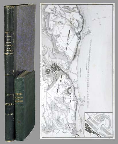
THIERS, Adolphe (1797-1877):
Histoire du Consulat et de l'Empire faisant suite à l'histoire de la Révolution française. 20 tomes + Atlas de l'histoire du Consulat et de l'Empire, dressé et dessiné sous la direction de M. Thiers par MM. Dufour et Duvotenay, gravé sur acier par Dyonnet. Ensemble 21 volumes.
Paris, Paulin-Lheureux, 1845-62, atlas (1866), in-8vo, atlas in-folio, chaque volume env. 500 p., l'atlas comprend 66 cartes dont 7 sur double-page montées sur onglets (deux coloriées), non paginé, toutes les cartes en excellent état + 2 cartes ajoutées: une carte du Nord de l'Italie pour l'étude de la campagne de Napoléon III en1859 par le colonel Suisse F. Lecomte et une carte en fac-similé de la ville de Paris en 1576, reliures en pleine percaline verte, dos et plats estampés de filets à froid, quelques frottements et usures. Atlas in-folio relié en demi-chagrin, dos à nerfs orné de filets dorés, Généralement bel ensemble.
Bookseller reference : 71051aaf
|
|
|
Thilo, G
Anschluß d. mecklenburgischen Landesvermessung an d. deutsche Einheitssystem.
Berlin, 1926. M. einigen Tab. 50 S. OBr. Umschl. kaum angestaubt. (Mitteil. d. Reichsamts für Landesaufnahme So.-H. 3).
Bookseller reference : 187311
|
|
|
Thilo, G
Unmittelbare Übertragung Schreiberscher in Gauß-Krügersche Koordinaten.
Berlin, 1928. M. einigen Tab. 55 S. OBr. Umschl. kaum angestaubt. (Mitteil. d. Reichsamts für Landesaufnahme So.-H. 5).
Bookseller reference : 187313
|
|
|
THOMAS (Charles E.)
Catalogue of the Very Choice and Important Collection of Works on Cartography, Shipbuilding and Navigation, Voyages and Travels, Early Maps and Atlases, Etc.
2 Parts, 16 plates, orig. printed wrappers, 937 lots.
|
|
|
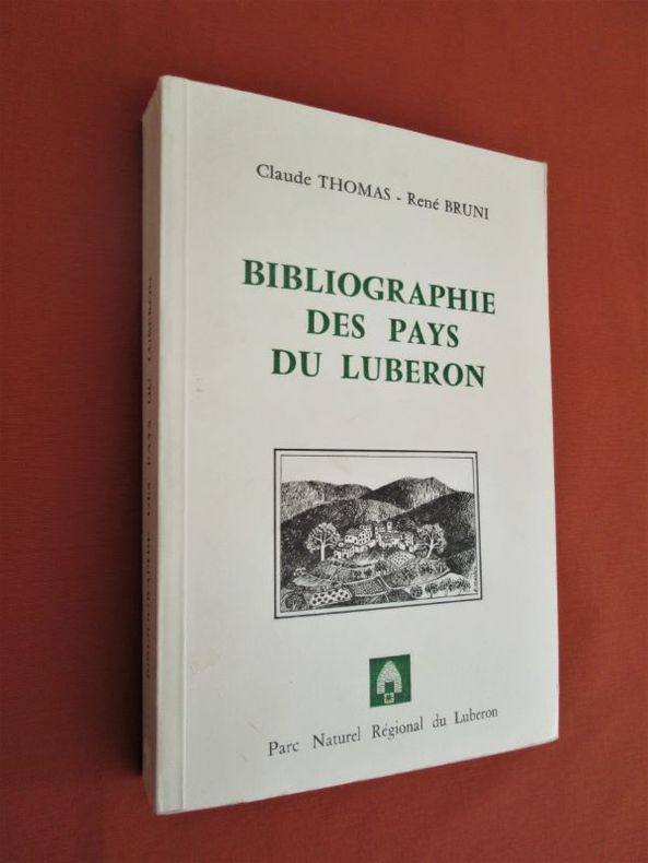
THOMAS (Claude) Et BRUNI (René)
Bibliographie des Pays du Luberon
Parc Naturel Régional Du Luberon, Isle sur la Sorgue, 1982. In-8 broché (21,5 x 14,5 cm), 368 pages, Illustrations in-texte et à pleine page. Carte dépliante en fin. Préface, avant propos.-670g.C. - Très bon état
Bookseller reference : 28648
|
|
|
THOMAS (Richard)
Hints for the Improvement of the Navigation of The Severn; Comprising Information which may be applicable to other Navigations.
First edition, 8vo (210 x 140 mm), 35, [1]pp., recent quarter calf, marbled boards, morocco title label to spine. Richard Thomas (1779-1858), civil engineer and surveyor, often referred to as Richard Thomas of Falmouth. This was his first appearance in print, on the verso of the terminal leaf is an advert for "A Chart of the Severn, On a large Scale, from an Actual Survey, Size 6 feet by 2 feet, by Richard Thomas". The former owner of this scarce pamphlet has noted "I have this Chart of the Severn - now with my other charts. 1890. N. W." Skempton, 1629; Not in the British Library.
|
|
|
Thomas Horst.
wereld in kaart, Gerard Mercator en de eerste wereldatlas (1512-1594)
, Mercator/ Mercatorfonds , 2011 Hardback, 325x245mm, 400p, 200 colour illustrations, Dutch (NL) edition . ISBN 978906153124113.
Bookseller reference : 30884
|
|
|
Thomas Horst.
wereld in kaart, Gerard Mercator en de eerste wereldatlas (1512-1594)
Hardback, 325x245mm, 400p, 200 colour illustrations, Dutch (NL) edition . ISBN 978906153124113. De Atlas van Mercator, de beroemdste atlas ter wereld, werd in 1595 in meerdere fascikels gedrukt en was al voor zijn tijdgenoten een sensatie. Gerard Mercator bedacht niet alleen het woord atlas voor een systematische verzameling van kaarten, maar hij ontwierp ook de zogenaamde Mercatorprojectie die vandaag nog altijd wordt gebruikt. Van de Atlas van Mercator zijn nog slechts weinig volledige exemplaren bewaard en daarvan zijn er maar enkele ingekleurd. In dit boek wordt een inleiding gegeven op leven en werk van de grote kosmograaf en worden alle kaarten uit de 'Editio principissima' die in de Staatsbibliothek zu Berlin wordt bewaard, in waarheidsgetrouwe kleuren gereproduceerd. Het werk is een hommage aan de uitvinder van het moderne wereldbeeld wiens vijfhonderste geboortedag in 2012 wordt gevierd.

|
|
|
THOMAS HUNT
Ghost trails to California (with selected excerpts from emigrant journal, a pictorial journey from the rockies to the gold country).
Weathervane, 1974, 262 pages, 30 cartes, photographies de Thomas Hunt et Robert Adams, in 4 reliure éditeur cartonnée et toilée bleue bon état, avec jaquette en état d'usage.
Bookseller reference : 12520
|
|
|
THOMAS MOULE
Engraved Map of Kent. ENGRAVED MAP FINELY COLOURED BY HAND
Steel-engraved map on paper; measuring 8.0 x 10.5 ins (approx. 20.00 x 26.5 cms), FINELY COLOURED BY HAND; attractively mounted in bevelled-edge steel-grey card with bevelled edges, a very good, bright, clean copy. The map is enclosed by an elaborate pictorial border incorporating four coats-of-arms and various other symbolic figures, and includes three charming vignettes of Greenwich Hospital, Rochester and Dover.

|
|
|
Thompson Edmund
Maps of Connecticut before the Year 1800 : A Descriptive List with Maps of Connecticut for the Years of the Industrial Revolution 1801-1860 : A Descriptive List
Norwich VT: G. B. Manasek Inc. 1995. Near Fine condition. Bright clean square and tight. NOT a library discard. NO owner's name or bookplate. NOT a remainder. Pages are clean and unmarked. NO underlining. NO highlighting. NO margin notes. 7.25" wide by 10.75" tall. 2 volumes bound as 1: Thompson's Maps of Connecticut before the Year 1800 A Descriptive List; and Thompson's Maps of Connecticut for the Years of Industrial Revolution 1801-1860 A Descriptive List. Reissue of this excellent illustrated cartobibliography that was originally published 1940/1942 in two separate volumes each limited to only 250 copies. Bound in the original blue cloth stamped in shiny gold. . Reprint of the 1940/1942 originals. Hardcover. Near Fine condition/No jacket as issued. 2 vols in 1: 66pp. 111pp. Great Packaging Fast Shipping. G. B. Manasek, Inc. Hardcover
Bookseller reference : 018404
|
|
|
Thompson Edmund
Maps of Connecticut before the Year 1800 : A Descriptive List with Maps of Connecticut for the Years of the Industrial Revolution 1801-1860 : A Descriptive List new in publisher's shrinkwrap
Norwich VT: G. B. Manasek Inc. 1995. Brand New in perfect condition. Still sealed in the publisher's clear plastic shrinkwrap. Bright clean square and tight. Sharp corners. NO remainder mark. Fresh and crisp. 7.25" wide by 10.75" tall. 2 volumes bound as 1: Thompson's Maps of Connecticut before the Year 1800 A Descriptive List; and Thompson's Maps of Connecticut for the Years of Industrial Revolution 1801-1860 A Descriptive List. Reissue of this excellent illustrated cartobibliography that was originally published 1940/1942 in two separate volumes each limited to only 250 copies. Bound in the original blue cloth stamped in shiny gold. . Reprint of the 1940/1942 originals. Hardcover. New/in publisher's shrinkwrap. 2 vols in 1: 66pp. 111pp. Great Packaging Fast Shipping. G. B. Manasek, Inc. Hardcover
Bookseller reference : 017211
|
|
|
THOMPSON (John) Engineer.
Plans & Sections of the Fleetwood-on-Wyre & Clitheroe Railway 1845.
Oblong folio (380 x 510 mm), title page followed by 13 plans, scale, 1 inch to 900 feet, 1 inch to 100 feet; enlargements: 1 inch to 6 chains, unfortunately all leaves and wrappers badly water damaged.
|
|
|
Thomson John
Map of ATTICA Greece - TURKISH DOMINIONS in EUROPE- 2 maps on one sheet
Edinburgh: John Thomson 1815. Original hand-colour fine scarce unfolded copy 490 X 700 From John Thomsons New General Atlas 1817 beautifully hand-coloured on thick paper. 1st edition. Fine. John Thomson unknown
Bookseller reference : Map697
|
|
|
Thomson John
Map of AUSTRIAN DOMINIANS
Edinburgh: John Thomson 1814. Original hand-colour fine scarce unfolded copy 510 x 610 From John Thomsons New General Atlas 1817 beautifully hand-coloured on thick paper. 1st edition. Fine. John Thomson unknown
Bookseller reference : Map710
|
|
|
Thomson John
Map of BRITISH INDIA - Southern Part
Edinburgh: John Thomson 1816. Original hand-colour fine scarce unfolded copy 510 X 610 From John Thomsons New General Atlas 1817 beautifully hand-coloured on thick paper. Fine. John Thomson unknown
Bookseller reference : Map696
|
|
|
Thomson John
Map of DENMARK
Edinburgh: John Thomson 1814. Original hand-colour fine scarce unfolded copy some chipping to top edge 510 x 610 From John Thomsons New General Atlas 1817 beautifully hand-coloured on thick paper. 1st edition. Fine. John Thomson unknown
Bookseller reference : Map702
|
|
|
Thomson John
Map of ENGLAND
Edinburgh: John Thomson 1814. Original hand-colour fine scarce unfolded copy 610 x 510 From John Thomsons New General Atlas 1817 beautifully hand-coloured on thick paper. 1st edition. Fine. John Thomson unknown
Bookseller reference : Map699
|
|
|
Thomson John
Map of EUROPE
Edinburgh: John Thomson 1817. Original hand-colour fine scarce unfolded copy 470 X 540 From John Thomsons New General Atlas 1817 beautifully hand-coloured on thick paper. Fine. John Thomson unknown
Bookseller reference : Map686
|
|
|
Thomson John
Map of FRANCE in Provinces
Edinburgh: John Thomson 1814. Original hand-colour fine scarce unfolded copy small damp stain to top margin and professional small repair to edge 510 X 580 From John Thomsons New General Atlas 1817 beautifully hand-coloured on thick paper. Fine. John Thomson unknown
Bookseller reference : Map683
|
|
|
Thomson John
Map of FRANCE in Departments
Edinburgh: John Thomson 1817. Original hand-colour fine scarce unfolded copy 510 X 620 From John Thomsons New General Atlas 1817 beautifully hand-coloured on thick paper. 1st edition. Fine. John Thomson unknown
Bookseller reference : Map693
|
|
|
Thomson John
Map of GERMANY- South of the Mayne
Edinburgh: John Thomson 1816. Original hand-colour fine scarce unfolded copy small damp stain to top edge 510 X 610 From John Thomsons New General Atlas 1817 beautifully hand-coloured on thick paper. Fine. John Thomson unknown
Bookseller reference : Map690
|
|
|
Thomson John
Map of NORTH AMERICA
Edinburgh: John Thomson 1817. Original hand-colour fine scarce unfolded copy small damp stain to bottom edge 510 X 610 From John Thomsons New General Atlas 1817 beautifully hand-coloured on thick paper. 1st edition. Fine. John Thomson unknown
Bookseller reference : Map688
|
|
|
Thomson John
Map of PERSIA
Edinburgh: John Thomson 1814. Original hand-colour fine scarce unfolded copy one edge sl. stain 470 x 520 From John Thomsons New General Atlas 1817 beautifully hand-coloured on thick paper. 1st edition. Fine. John Thomson unknown
Bookseller reference : Map705
|
|
|
Thomson John
Map of PRUSSIAN DOMINIANS
Edinburgh: John Thomson 1816. Original hand-colour fine scarce unfolded copy 490 X 620 From John Thomsons New General Atlas 1817 beautifully hand-coloured on thick paper. Fine. John Thomson unknown
Bookseller reference : Map694
|
|
|
Thomson John
Map of SCANDINAVIA
Edinburgh: John Thomson 1817. Original hand-colour fine scarce unfolded copy 620 X 490 From John Thomsons New General Atlas 1817 beautifully hand-coloured on thick paper. 1st edition. Fine. John Thomson unknown
Bookseller reference : Map687
|
|
|
Thomson John
Map of SPAIN & PORTUGAL
Edinburgh: John Thomson 1817. Original hand-colour fine scarce unfolded copy 530 x 670mm From John Thomson's New General Atlas 1817 beautifully hand-coloured on thick paper wide margins. 1st edition. Fine. John Thomson unknown
Bookseller reference : Map684
|
|
|
Thomson John
Map of SPANISH NORTH AMERICA - Southern Part. Inc. Jamaica
Edinburgh: John Thomson 1816. Original hand-colour fine scarce unfolded copy small damp stain to top margin 510 X 610 From John Thomsons New General Atlas 1817 beautifully hand-coloured on thick paper. 1st edition. Fine. John Thomson unknown
Bookseller reference : Map682
|
|
|
Thomson John
Map of THE BRITISH CHANNEL
Edinburgh: John Thomson 1814. Original hand-colour fine scarce unfolded copy 520 X 650 From John Thomsons New General Atlas 1817 beautifully hand-coloured on thick paper. Fine. John Thomson unknown
Bookseller reference : Map689
|
|
|
Thomson John
Map of TURKEY in ASIA
Edin`: John Thomson 1817. Original hand-colour fine scarce unfolded copy one edge sl. Stain 410 x 520 From John Thomsons New General Atlas 1817 beautifully hand-coloured on thick paper. 1st edition. Fine. John Thomson unknown
Bookseller reference : Map706
|
|
|
Thomson John
VENETIAN STATES Map
Edinburgh: John Thomson 1816. Original hand-colour fine scarce unfolded copy minor damp stain 510 X 610 From John Thomsons New General Atlas 1817 beautifully hand-coloured on thick paper. 1st edition. Fine. John Thomson unknown
Bookseller reference : Map685
|
|
|
THONE Karl -
Karte und kompass.
Bern, Hallwag, (anni 50), 16mo legatura mezza tela editoriale con copertina illustrata, pp. 80 con 50 illustrazioni n.t.

|
|
|
Thrower Norman J. W
The Compleat Plattmaker : Essays on Chart Map and Globe Making in England in the Seventeenth and Eighteenth Centuries
Berkeley Los Angeles London: University of California Press 1978. NOT a library discard. Fine condition. Bright clean square and tight. Sharp corners. NO owner's name or bookplate. NO remainder mark. Fresh and crisp - probably never read. NO underlining. NO highlighting. NO margin notes. Contains a preface and 6 cartographical essays -- by Helen M. Wallis; Thomas R. Smith; Jeannette D. Black; Coolie Verner; David A. Woodward; and Norman J. W. Thrower. Illustrated. Index. Bound in the original gold cloth stamped in blue. First Edition. Hardcover. Fine condition/No jacket probably as issued. 8vo. xvii 241pp. Great Packaging Fast Shipping. University of California Press Hardcover
Bookseller reference : 018832 ISBN : 0520035224 9780520035225
|
|
|
TIBERGHIEN Albert -
Note sur la carte de Ferraris.
Liège, 1909, 8vo stralcio con copertina posticcia muta, pp. 371/382. - !! ATTENZIONE !!: Con il termine estratto (o stralcio) intendiamo riferirci ad un fascicolo contenente un articolo, completo in se, sia che esso sia stato stampato a parte utilizzando la stessa composizione sia che provenga direttamente da una rivista. Le pagine sono indicate come "da/a", ad esempio: 229/231 significa che il testo è composto da tre pagine. Quando la rivista di provenienza non viene indicata é perché ci è sconosciuta. - !! ATTENTION !!: : NOT A BOOK : “extract” or “excerpt” means simply a few pages, original nonetheless, printed in a magazine. Pages are indicated as in "from” “to", for example: 229/231 means the text comprises three pages (229, 230 and 231). If the magazine that contained the pages is not mentioned, it is because it is unknown to us.

|
|
|
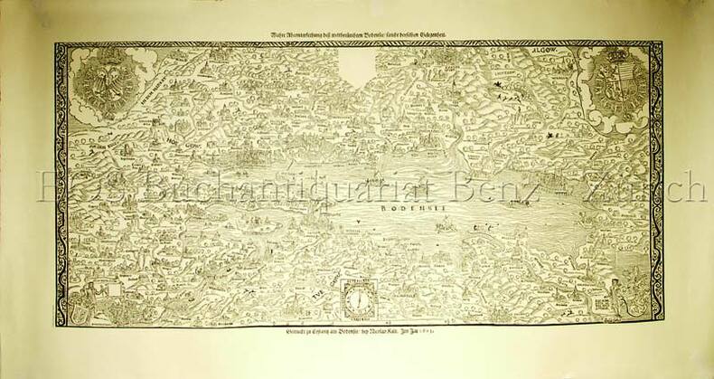
Tibian, Johann Georg (1541-1611)
Wahre Abcontersethung dess weltberühmten Bodensee / sambt derselben Gelegenheit - Gedruckt zu Constantz am Bodensee bey Nicolav Kalt. Im Jar 1603.
Gattikon, Dorfpresse, o.J. (um 1960). Faksimiledruck. Blattformat: 53 x 100 cm. + Wichtig: Für unsere Kunden in der EU erfolgt der Versand alle 14 Tage verzollt ab Deutschland / Postbank-Konto in Deutschland vorhanden +, 1633AG
Bookseller reference : 1633AG

|
|
|
Tibian, Johann Georg (1541-1611):
Wahre Abcontersethung dess weltberühmten Bodensee / sambt derselben Gelegenheit - Gedruckt zu Constantz am Bodensee bey Nicolav Kalt. Im Jar 1603.
Gattikon, Dorfpresse, o.J. (um 1960). Faksimiledruck. Blattformat: 53 x 100 cm.
Bookseller reference : 1633AG
|
|
|
TIBOR Szathmary -
Descriptio Hungariae. I. Magyarorszag es Erdely Nyomtatott Terkepei 1477-1600.
Fusignano, Grafiche Morandi, 1988, album in 4to (cm. 32,5 x 35) legatura piena pelle con fregi e titoli dorati al piatto anteriore e al dorso, sovraccopertina illustrata a colori e cordoncino in seta, pp. 261 con 111 carte a colori nel testo.

|
|
|
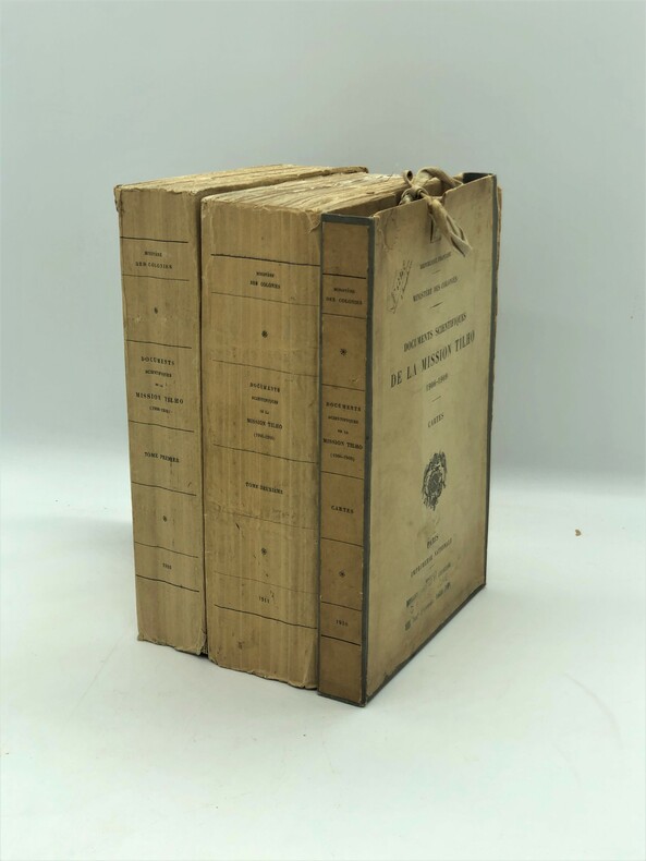
TILHO Jean
Documents scientifiques de la mission Tilho (1906-1909)
Paris, Imprimerie Nationale, 1910-1911, in-4, 2 fort volumes brochés et un étui LX-412 pages et 76 planches et cartes (dont plusieurs dépliantes) + VIII-631-[1] pages, 131 planches et cartes ; 9 cartes(2 en double, manque la carte du Aïr), sous étui cartonné à rubans de l'éditeur, Unique édition, très rare avec les cartes. Ouvrage fondamental pour la connaissance des régions du Tchad et du Niger. Bon exemplaire, non coupé.
Bookseller reference : PHO-659
|
|
|
TINDAL (M.).
Plan of the Incampment of the Allies at Prats del Rey under the command of the Count Staremberg; and of ye Enemy under the Duke of Vendosme, Where ye two Armies …
Sin lugar ni año (Siglo XVIII), mapa grabado en madera, de 45'5 x 37 cm.
|
|
|
TIRELLI Vito (premessa di)
TERRE DI CONFINE. La cartografia della Val di Serchio tra dominio lucchese ed estense nei sec. XVI-XVIII. Lucca, Villa Bottini, 7 Dicembre 1987 - 10 Gennaio 1988.
In-8 (cm. 21.20), brossura illustrata, pp. 151, (5), con illustrazioni a colori nel testo. In buono stato (good copy).
|
|
|
TIRINUS, JACOBUS.
Chorographia Terrae Sanctae in Angustiorem formam Redacta, et ex Variis Auctoribus a Multis Erroribus Expurgata.
Anversa, 1632. Incisione in rame, b/n, cm 32,5 x 84,8 (la parte incisa). Veduta cartografica in oblungo, più volte ripiegata, raffigurante la Terra Santa, 18 piccoli riquadri ai margini mostrano il tempio e i suoi strumenti. Cartografata e stampata da Jacobus Tirinus (1580 - 1636), belga, gesuita e studioso biblico, la carta uscì ad Anversa nel 1632; al centro la pianta di Gerusalemme basata sul celebre modello di Villalpando, pubblicato nello "Hierosolymae Veteris Imago". Rara. Esemplare stampato su carta fine, carta velina applicata al verso, stretti margini, una piccola abrasione interessa la parte centrale del foglio e una, rimarginata, la parte sinistra dell'inciso da un terzo superiore del foglio fino al margine inferiore. Nell'insieme resta discreta la lettura della carta che si presenta con una buona impressione dell'inciso.

|
|
|
Tishby, Ariel [Ed.]
Holy Land in Maps
27.5x23.5 cm. 168 pages. Gilt hardcover with dust jacket. Pages bottom edge water stained. Else in good condition. PLEASE NOTE: This item is overweight. We may ask for extra shipping costs.
|
|
|
Tizzoni,Paolo. (a cura di).
Piani di bacino. Strumento per il governo del territorio. Dalla tutela ambientale e salvaguerdia della sicurezza a
<br/> STATO: NUOVO.<br/> TITOLO: Piani di bacino. Strumento per il governo del territorio. Dalla tutela ambientale e salvaguerdia della sicurezza al miglior sviluppo sostenibile.<br/> AUTORE: Tizzoni,Paolo. (a cura di).<br/> CURATORE: A cura dell'Ordine Regionale Geologi della Liguria.<br/> EDITORE: Supplem.a Professione Geologo<br/> DATA ED.: 1997,<br/>

|
|
|
TOBBACK L. & GILLARDIN J.
Carte des Productions Animales avec une annexe: Pêche et pisciculture (Atlas général du Congo, 723). Kaart van de dierlijke producties met een bijlage: Visserij en visteelt (Algemene Atlas van Congo, 723)
Bruxelles-Brussel, Institut royal colonial belge/ Koninklijk belgisch koloniaal instituut 1951 bilingue: Français-Néerlandais, 15 + 15pp. + 1 grande carte dépliante en couleurs, en feuilles sous étui d'éditeur, 37x37cm., bon état, [Publication dans la série "Atlas général du Congo. Algemene Atlas van Congo" sous index no.723], C100352
Bookseller reference : C100352
|
|
|
TOBBACK L. & GILLARDIN J.
Carte des Productions Animales avec une annexe: Pêche et pisciculture (Atlas général du Congo, 723). Kaart van de dierlijke producties met een bijlage: Visserij en visteelt (Algemene Atlas van Congo, 723)
bilingue: Français-Néerlandais, 15 + 15pp. + 1 grande carte dépliante en couleurs, en feuilles sous étui d'éditeur, 37x37cm., bon état, [Publication dans la série "Atlas général du Congo. Algemene Atlas van Congo" sous index no.723], C100352
|
|
|
TOCI G. DISEGNO / CICERI EUG. LIT.
VUE DE MONTECERBOLI / PERSPECTIVE DE LA ROUTE ET DU PONT CONSTRUIT PAR LE COMTE DE LARDEREL / ET QUI CONDUISENT A LARDERELLO
LITOGRAFIA mm.320 X 545 ( ved.) + MARGINI.PUBBLICATA IN: ALBUM DES DIVERSES LOCALITES FORMANT LES ETABLISSEMENS INDUSTRIELS D'ACIDE BORACIQUE FONDES EN TOSCANE ( 1818 ). PAR LE COMTE DE LARDEREL. PARIS ( 1853 ). MINIMI STRAPPETTI MARGINALI DEL FOGLIO NELLA PARTE BIANCA, ALTRIMENTI OTTIMA CONSERVAZIONE GENERALE. ID, 6702

|
|
|
TOM STERLING
L'Amazonie .
Collection les les grandes étendues sauvages ,éditions time life 1979 très bon état 184 pages in 4.
Bookseller reference : 3651
|
|
|
TOM STERLING COLLECTIF
L'Amazonie.
Editions Time Life, les grandes étendues sauvages, 1979, bon état, in 4 couverture cartonnée dos et mors toilés, 184 pages de textes et photos.
Bookseller reference : 6495
|
|
 Receive by email
 Download as PDF document
 RSS feed


