|
|
|
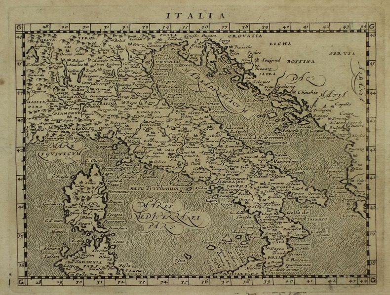
MAGINI (Giovanni Antonio) & PTOLEMEE (Claude).
Italia.
[Arnhem, Joannes Jansson, 1617]. 129 x 170 mm.
Bookseller reference : LBW-1933
|
|
|
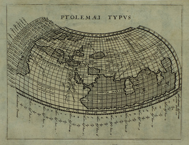
MAGINI (Giovanni Antonio) & PTOLEMEE (Claude).
Ptolemaei typus.
[Arnhem, Joannes Jansson, 1617]. 132 x 172 mm.
Bookseller reference : LBW-1937
|
|
|
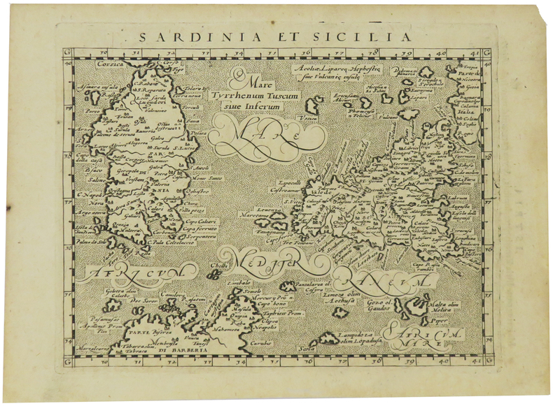
MAGINI (Giovanni Antonio) & PTOLEMEE (Claude).
Sardinia et Sicilia.
[Arnhem, Joannes Jansson, 1617]. 130 x 169 mm.
Bookseller reference : LBW-1935
|
|
|
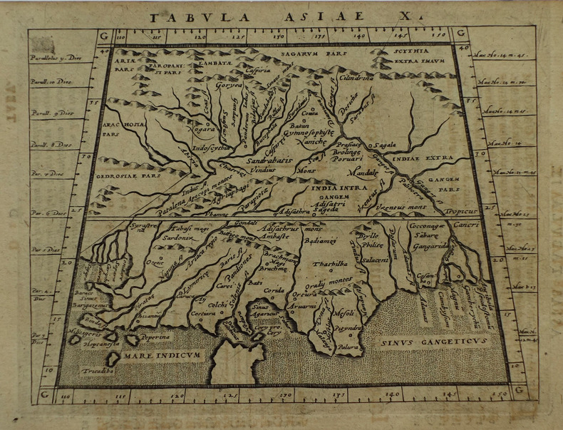
MAGINI (Giovanni Antonio) & PTOLEMEE (Claude).
Tabula Asiae X.
[Arnhem, Joannes Jansson, 1617]. 129 x 167 mm.
Bookseller reference : LBW-1932
|
|
|
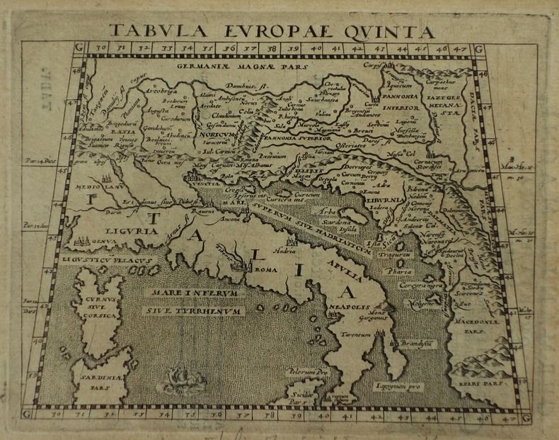
MAGINI (Giovanni Antonio) & PTOLEMEE (Claude).
Tabula Europae quinta.
[Arnhem, Joannes Jansson, 1617]. 127 x 163 mm.
Bookseller reference : LBW-1931
|
|
|
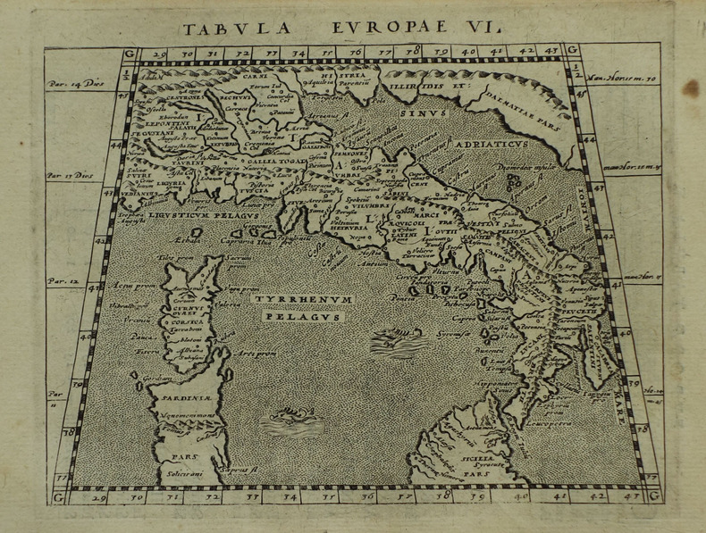
MAGINI (Giovanni Antonio) & PTOLEMEE (Claude).
Tabula Europae VI.
[Arnhem, Joannes Jansson, 1617]. 130 x 166 mm.
Bookseller reference : LBW-1921
|
|
|
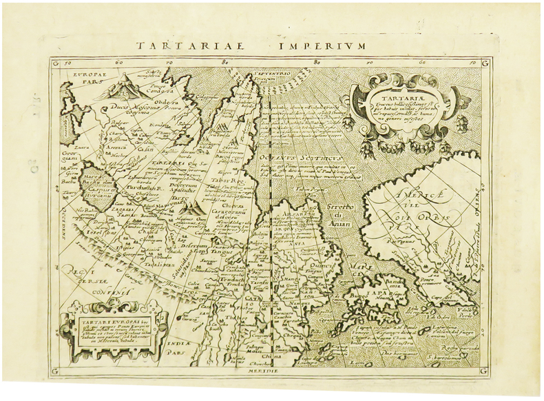
MAGINI (Giovanni Antonio) & PTOLEMEE (Claude).
Tartariae imperium.
[Arnhem, Joannes Jansson, 1617]. 129 x 170 mm.
Bookseller reference : LBW-1964
|
|
|
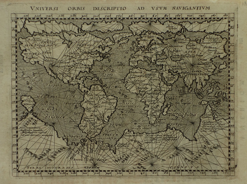
MAGINI (Giovanni Antonio) & PTOLEMEE (Claude).
Universi orbis descriptio ad usum navigantium.
[Arnhem, Joannes Jansson, 1617]. 131 x 172 mm.
Bookseller reference : LBW-1922
|
|
|
MAGNAGHI, Alberto
La carta nautica costruita nel 1325 da Angelino Dalorto
In -4°, pp. 15 più una grande carta più volte ripiegata. E’ la riproduzione fotozincografica della carta di Dalorto, che rappresentava con notevole dettaglio per l’epoca la costa del Nord Europa. It’s the photozincographic reprodution of Dalorto’s Map, detailing the Northern European Coast.
|
|
|
MAGNAN Dominique (29 maggio 1731, Reillanne, Francia - agosto 1796, Firenze)
Arenula seu Regula Regio VII
Pianta del rione tratta dalla celebre guida di Roma di Dominique Magnan La ville de Rome, ou, Description abrégée de cette superbe ville: divisée en quatre volumes: et ornée de 425 planches en taille douce. A Rome: De l'imprimerie d'Archange Casaletti ... : Chez Venan. Monaldini, Bouchard et Gravier : Gregoire Settari ..., 1778. Dominique Magnan (1731–1796), dotto abate francese del convento della Trinità dei Monti, dell'ordine dei minimi, a Roma, che fu profondamente coinvolto nella vita intellettuale della sua comunità durante la seconda metà del XVIII secolo. Ha studiato all'università di Avignone, poi si è unito ai Minimi di La Ciotat all'età di 20 anni, dove ha iniziato la sua carriera come collezionista di monete e medaglie antiche. Nominato professore di teologia a Marsiglia, ha continuato il suo lavoro. Si mise in contatto con i più famosi antiquari dell'epoca, sia in Italia che in Germania, e acquisì rapidamente una vasta reputazione. I suoi primi libri hanno ricevuto il plauso della critica. Ma i suoi lavori più significativi erano sulla numismatica sebbene fortemente criticati dagli specialisti dell'epoca in quanto la copertura universale e completa del soggetto poteva mantenere la confusione tra monete autentiche e false. Bibliografia: Rossetti, G-1285; Schudt 363. Map taken from the famous guide of Rome by Dominique Magnan La ville de Rome, ou, Description abrégée de cette superbe ville: divisée en quatre volumes: et ornée de 425 planches en taille douce. A Rome: De l'imprimerie d'Archange Casaletti ... : Chez Venan. Monaldini, Bouchard et Gravier : Gregoire Settari ..., 1778. Dominique Magnan (1731–1796), a learned French abbot of the Trinità dei Monti convent, of the order of the minims, in Rome, who was deeply involved in the intellectual life of his community during the second half of the 18th century. He studied at the University of Avignon, then joined the Minims of La Ciotat at age 20, where he began his career as a collector of ancient coins and medals. Appointed professor of theology in Marseille, he continued his work. He got in touch with the most famous antiquaries of the time, both in Italy and Germany, and speedily acquired an extensive reputation. His first books received critical acclaim. But his most significant works were on numismatics though heavily criticized by specialists of the time in that universal and complete coverage of the subject could maintain confusion between authentic coins and the fake ones. Bibliografia: Rossetti, G-1285; Schudt 363.

|
|
|
MAGNAN Dominique (29 maggio 1731, Reillanne, Francia - agosto 1796, Firenze)
Campi Martii Regio IV Romana qualis erat anno 1777
Pianta del rione tratta dalla celebre guida di Roma di Dominique Magnan La ville de Rome, ou, Description abrégée de cette superbe ville: divisée en quatre volumes: et ornée de 425 planches en taille douce. A Rome: De l'imprimerie d'Archange Casaletti ... : Chez Venan. Monaldini, Bouchard et Gravier : Gregoire Settari ..., 1778. Dominique Magnan (1731–1796), dotto abate francese del convento della Trinità dei Monti, dell'ordine dei minimi, a Roma, che fu profondamente coinvolto nella vita intellettuale della sua comunità durante la seconda metà del XVIII secolo. Ha studiato all'università di Avignone, poi si è unito ai Minimi di La Ciotat all'età di 20 anni, dove ha iniziato la sua carriera come collezionista di monete e medaglie antiche. Nominato professore di teologia a Marsiglia, ha continuato il suo lavoro. Si mise in contatto con i più famosi antiquari dell'epoca, sia in Italia che in Germania, e acquisì rapidamente una vasta reputazione. I suoi primi libri hanno ricevuto il plauso della critica. Ma i suoi lavori più significativi erano sulla numismatica sebbene fortemente criticati dagli specialisti dell'epoca in quanto la copertura universale e completa del soggetto poteva mantenere la confusione tra monete autentiche e false. Bibliografia: Rossetti, G-1285; Schudt 363. Map taken from the famous guide of Rome by Dominique Magnan La ville de Rome, ou, Description abrégée de cette superbe ville: divisée en quatre volumes: et ornée de 425 planches en taille douce. A Rome: De l'imprimerie d'Archange Casaletti ... : Chez Venan. Monaldini, Bouchard et Gravier : Gregoire Settari ..., 1778. Dominique Magnan (1731–1796), a learned French abbot of the Trinità dei Monti convent, of the order of the minims, in Rome, who was deeply involved in the intellectual life of his community during the second half of the 18th century. He studied at the University of Avignon, then joined the Minims of La Ciotat at age 20, where he began his career as a collector of ancient coins and medals. Appointed professor of theology in Marseille, he continued his work. He got in touch with the most famous antiquaries of the time, both in Italy and Germany, and speedily acquired an extensive reputation. His first books received critical acclaim. But his most significant works were on numismatics though heavily criticized by specialists of the time in that universal and complete coverage of the subject could maintain confusion between authentic coins and the fake ones. Bibliografia: Rossetti, G-1285; Schudt 363.

|
|
|
MAGNAN Dominique (29 maggio 1731, Reillanne, Francia - agosto 1796, Firenze)
Columnae Regio III Romana qualis erat anno 1777
Pianta del rione tratta dalla celebre guida di Roma di Dominique Magnan La ville de Rome, ou, Description abrégée de cette superbe ville: divisée en quatre volumes: et ornée de 425 planches en taille douce. A Rome: De l'imprimerie d'Archange Casaletti ... : Chez Venan. Monaldini, Bouchard et Gravier : Gregoire Settari ..., 1778. Dominique Magnan (1731–1796), dotto abate francese del convento della Trinità dei Monti, dell'ordine dei minimi, a Roma, che fu profondamente coinvolto nella vita intellettuale della sua comunità durante la seconda metà del XVIII secolo. Ha studiato all'università di Avignone, poi si è unito ai Minimi di La Ciotat all'età di 20 anni, dove ha iniziato la sua carriera come collezionista di monete e medaglie antiche. Nominato professore di teologia a Marsiglia, ha continuato il suo lavoro. Si mise in contatto con i più famosi antiquari dell'epoca, sia in Italia che in Germania, e acquisì rapidamente una vasta reputazione. I suoi primi libri hanno ricevuto il plauso della critica. Ma i suoi lavori più significativi erano sulla numismatica sebbene fortemente criticati dagli specialisti dell'epoca in quanto la copertura universale e completa del soggetto poteva mantenere la confusione tra monete autentiche e false. Bibliografia: Rossetti, G-1285; Schudt 363. Map taken from the famous guide of Rome by Dominique Magnan La ville de Rome, ou, Description abrégée de cette superbe ville: divisée en quatre volumes: et ornée de 425 planches en taille douce. A Rome: De l'imprimerie d'Archange Casaletti ... : Chez Venan. Monaldini, Bouchard et Gravier : Gregoire Settari ..., 1778. Dominique Magnan (1731–1796), a learned French abbot of the Trinità dei Monti convent, of the order of the minims, in Rome, who was deeply involved in the intellectual life of his community during the second half of the 18th century. He studied at the University of Avignon, then joined the Minims of La Ciotat at age 20, where he began his career as a collector of ancient coins and medals. Appointed professor of theology in Marseille, he continued his work. He got in touch with the most famous antiquaries of the time, both in Italy and Germany, and speedily acquired an extensive reputation. His first books received critical acclaim. But his most significant works were on numismatics though heavily criticized by specialists of the time in that universal and complete coverage of the subject could maintain confusion between authentic coins and the fake ones. Bibliografia: Rossetti, G-1285; Schudt 363.

|
|
|
MAGNAN Dominique (29 maggio 1731, Reillanne, Francia - agosto 1796, Firenze)
Montes Regio I. Romana qualis erat anno 1777
Pianta del rione tratta dalla celebre guida di Roma di Dominique Magnan La ville de Rome, ou, Description abrégée de cette superbe ville: divisée en quatre volumes: et ornée de 425 planches en taille douce. A Rome: De l'imprimerie d'Archange Casaletti ... : Chez Venan. Monaldini, Bouchard et Gravier : Gregoire Settari ..., 1778. Dominique Magnan (1731–1796), dotto abate francese del convento della Trinità dei Monti, dell'ordine dei minimi, a Roma, che fu profondamente coinvolto nella vita intellettuale della sua comunità durante la seconda metà del XVIII secolo. Ha studiato all'università di Avignone, poi si è unito ai Minimi di La Ciotat all'età di 20 anni, dove ha iniziato la sua carriera come collezionista di monete e medaglie antiche. Nominato professore di teologia a Marsiglia, ha continuato il suo lavoro. Si mise in contatto con i più famosi antiquari dell'epoca, sia in Italia che in Germania, e acquisì rapidamente una vasta reputazione. I suoi primi libri hanno ricevuto il plauso della critica. Ma i suoi lavori più significativi erano sulla numismatica sebbene fortemente criticati dagli specialisti dell'epoca in quanto la copertura universale e completa del soggetto poteva mantenere la confusione tra monete autentiche e false. Bibliografia: Rossetti, G-1285; Schudt 363. Map taken from the famous guide of Rome by Dominique Magnan La ville de Rome, ou, Description abrégée de cette superbe ville: divisée en quatre volumes: et ornée de 425 planches en taille douce. A Rome: De l'imprimerie d'Archange Casaletti ... : Chez Venan. Monaldini, Bouchard et Gravier : Gregoire Settari ..., 1778. Dominique Magnan (1731–1796), a learned French abbot of the Trinità dei Monti convent, of the order of the minims, in Rome, who was deeply involved in the intellectual life of his community during the second half of the 18th century. He studied at the University of Avignon, then joined the Minims of La Ciotat at age 20, where he began his career as a collector of ancient coins and medals. Appointed professor of theology in Marseille, he continued his work. He got in touch with the most famous antiquaries of the time, both in Italy and Germany, and speedily acquired an extensive reputation. His first books received critical acclaim. But his most significant works were on numismatics though heavily criticized by specialists of the time in that universal and complete coverage of the subject could maintain confusion between authentic coins and the fake ones. Bibliografia: Rossetti, G-1285; Schudt 363.

|
|
|
MAGNAN Dominique (29 maggio 1731, Reillanne, Francia - agosto 1796, Firenze)
Parionis Regio VI. Romana qualis erat anno 1777
Pianta del rione tratta dalla celebre guida di Roma di Dominique Magnan La ville de Rome, ou, Description abrégée de cette superbe ville: divisée en quatre volumes: et ornée de 425 planches en taille douce. A Rome: De l'imprimerie d'Archange Casaletti ... : Chez Venan. Monaldini, Bouchard et Gravier : Gregoire Settari ..., 1778. Dominique Magnan (1731–1796), dotto abate francese del convento della Trinità dei Monti, dell'ordine dei minimi, a Roma, che fu profondamente coinvolto nella vita intellettuale della sua comunità durante la seconda metà del XVIII secolo. Ha studiato all'università di Avignone, poi si è unito ai Minimi di La Ciotat all'età di 20 anni, dove ha iniziato la sua carriera come collezionista di monete e medaglie antiche. Nominato professore di teologia a Marsiglia, ha continuato il suo lavoro. Si mise in contatto con i più famosi antiquari dell'epoca, sia in Italia che in Germania, e acquisì rapidamente una vasta reputazione. I suoi primi libri hanno ricevuto il plauso della critica. Ma i suoi lavori più significativi erano sulla numismatica sebbene fortemente criticati dagli specialisti dell'epoca in quanto la copertura universale e completa del soggetto poteva mantenere la confusione tra monete autentiche e false. Bibliografia: Rossetti, G-1285; Schudt 363. Map taken from the famous guide of Rome by Dominique Magnan La ville de Rome, ou, Description abrégée de cette superbe ville: divisée en quatre volumes: et ornée de 425 planches en taille douce. A Rome: De l'imprimerie d'Archange Casaletti ... : Chez Venan. Monaldini, Bouchard et Gravier : Gregoire Settari ..., 1778. Dominique Magnan (1731–1796), a learned French abbot of the Trinità dei Monti convent, of the order of the minims, in Rome, who was deeply involved in the intellectual life of his community during the second half of the 18th century. He studied at the University of Avignon, then joined the Minims of La Ciotat at age 20, where he began his career as a collector of ancient coins and medals. Appointed professor of theology in Marseille, he continued his work. He got in touch with the most famous antiquaries of the time, both in Italy and Germany, and speedily acquired an extensive reputation. His first books received critical acclaim. But his most significant works were on numismatics though heavily criticized by specialists of the time in that universal and complete coverage of the subject could maintain confusion between authentic coins and the fake ones. Bibliografia: Rossetti, G-1285; Schudt 363.

|
|
|
MAGNAN Dominique (29 maggio 1731, Reillanne, Francia - agosto 1796, Firenze)
Pinea Regio IX Romana qualis erat anno 1777
Pianta del rione tratta dalla celebre guida di Roma di Dominique Magnan La ville de Rome, ou, Description abrégée de cette superbe ville: divisée en quatre volumes: et ornée de 425 planches en taille douce. A Rome: De l'imprimerie d'Archange Casaletti ... : Chez Venan. Monaldini, Bouchard et Gravier : Gregoire Settari ..., 1778. Dominique Magnan (1731–1796), dotto abate francese del convento della Trinità dei Monti, dell'ordine dei minimi, a Roma, che fu profondamente coinvolto nella vita intellettuale della sua comunità durante la seconda metà del XVIII secolo. Ha studiato all'università di Avignone, poi si è unito ai Minimi di La Ciotat all'età di 20 anni, dove ha iniziato la sua carriera come collezionista di monete e medaglie antiche. Nominato professore di teologia a Marsiglia, ha continuato il suo lavoro. Si mise in contatto con i più famosi antiquari dell'epoca, sia in Italia che in Germania, e acquisì rapidamente una vasta reputazione. I suoi primi libri hanno ricevuto il plauso della critica. Ma i suoi lavori più significativi erano sulla numismatica sebbene fortemente criticati dagli specialisti dell'epoca in quanto la copertura universale e completa del soggetto poteva mantenere la confusione tra monete autentiche e false. Bibliografia: Rossetti, G-1285; Schudt 363. Map taken from the famous guide of Rome by Dominique Magnan La ville de Rome, ou, Description abrégée de cette superbe ville: divisée en quatre volumes: et ornée de 425 planches en taille douce. A Rome: De l'imprimerie d'Archange Casaletti ... : Chez Venan. Monaldini, Bouchard et Gravier : Gregoire Settari ..., 1778. Dominique Magnan (1731–1796), a learned French abbot of the Trinità dei Monti convent, of the order of the minims, in Rome, who was deeply involved in the intellectual life of his community during the second half of the 18th century. He studied at the University of Avignon, then joined the Minims of La Ciotat at age 20, where he began his career as a collector of ancient coins and medals. Appointed professor of theology in Marseille, he continued his work. He got in touch with the most famous antiquaries of the time, both in Italy and Germany, and speedily acquired an extensive reputation. His first books received critical acclaim. But his most significant works were on numismatics though heavily criticized by specialists of the time in that universal and complete coverage of the subject could maintain confusion between authentic coins and the fake ones. Bibliografia: Rossetti, G-1285; Schudt 363.

|
|
|
MAGNAN Dominique (29 maggio 1731, Reillanne, Francia - agosto 1796, Firenze)
Ripae Regio XIII. Romana qualis erat anno 1777
Pianta del rione tratta dalla celebre guida di Roma di Dominique Magnan La ville de Rome, ou, Description abrégée de cette superbe ville: divisée en quatre volumes: et ornée de 425 planches en taille douce. A Rome: De l'imprimerie d'Archange Casaletti ... : Chez Venan. Monaldini, Bouchard et Gravier : Gregoire Settari ..., 1778. Dominique Magnan (1731–1796), dotto abate francese del convento della Trinità dei Monti, dell'ordine dei minimi, a Roma, che fu profondamente coinvolto nella vita intellettuale della sua comunità durante la seconda metà del XVIII secolo. Ha studiato all'università di Avignone, poi si è unito ai Minimi di La Ciotat all'età di 20 anni, dove ha iniziato la sua carriera come collezionista di monete e medaglie antiche. Nominato professore di teologia a Marsiglia, ha continuato il suo lavoro. Si mise in contatto con i più famosi antiquari dell'epoca, sia in Italia che in Germania, e acquisì rapidamente una vasta reputazione. I suoi primi libri hanno ricevuto il plauso della critica. Ma i suoi lavori più significativi erano sulla numismatica sebbene fortemente criticati dagli specialisti dell'epoca in quanto la copertura universale e completa del soggetto poteva mantenere la confusione tra monete autentiche e false. Bibliografia: Rossetti, G-1285; Schudt 363. Map taken from the famous guide of Rome by Dominique Magnan La ville de Rome, ou, Description abrégée de cette superbe ville: divisée en quatre volumes: et ornée de 425 planches en taille douce. A Rome: De l'imprimerie d'Archange Casaletti ... : Chez Venan. Monaldini, Bouchard et Gravier : Gregoire Settari ..., 1778. Dominique Magnan (1731–1796), a learned French abbot of the Trinità dei Monti convent, of the order of the minims, in Rome, who was deeply involved in the intellectual life of his community during the second half of the 18th century. He studied at the University of Avignon, then joined the Minims of La Ciotat at age 20, where he began his career as a collector of ancient coins and medals. Appointed professor of theology in Marseille, he continued his work. He got in touch with the most famous antiquaries of the time, both in Italy and Germany, and speedily acquired an extensive reputation. His first books received critical acclaim. But his most significant works were on numismatics though heavily criticized by specialists of the time in that universal and complete coverage of the subject could maintain confusion between authentic coins and the fake ones. Bibliografia: Rossetti, G-1285; Schudt 363.

|
|
|
MAGNAN Dominique (29 maggio 1731, Reillanne, Francia - agosto 1796, Firenze)
Roma qualis erat anno 1777
Pianta tratta dalla celebre guida di Roma di Dominique Magnan La ville de Rome, ou, Description abrégée de cette superbe ville: divisée en quatre volumes: et ornée de 425 planches en taille douce. A Rome: De l'imprimerie d'Archange Casaletti ... : Chez Venan. Monaldini, Bouchard et Gravier : Gregoire Settari ..., 1778. Dominique Magnan (1731–1796), dotto abate francese del convento della Trinità dei Monti, dell'ordine dei minimi, a Roma, che fu profondamente coinvolto nella vita intellettuale della sua comunità durante la seconda metà del XVIII secolo. Ha studiato all'università di Avignone, poi si è unito ai Minimi di La Ciotat all'età di 20 anni, dove ha iniziato la sua carriera come collezionista di monete e medaglie antiche. Nominato professore di teologia a Marsiglia, ha continuato il suo lavoro. Si mise in contatto con i più famosi antiquari dell'epoca, sia in Italia che in Germania, e acquisì rapidamente una vasta reputazione. I suoi primi libri hanno ricevuto il plauso della critica. Ma i suoi lavori più significativi erano sulla numismatica sebbene fortemente criticati dagli specialisti dell'epoca in quanto la copertura universale e completa del soggetto poteva mantenere la confusione tra monete autentiche e false. Bibliografia: Rossetti, G-1285; Schudt 363. Map taken from the famous guide of Rome by Dominique Magnan La ville de Rome, ou, Description abrégée de cette superbe ville: divisée en quatre volumes: et ornée de 425 planches en taille douce. A Rome: De l'imprimerie d'Archange Casaletti ... : Chez Venan. Monaldini, Bouchard et Gravier : Gregoire Settari ..., 1778. Dominique Magnan (1731–1796), a learned French abbot of the Trinità dei Monti convent, of the order of the minims, in Rome, who was deeply involved in the intellectual life of his community during the second half of the 18th century. He studied at the University of Avignon, then joined the Minims of La Ciotat at age 20, where he began his career as a collector of ancient coins and medals. Appointed professor of theology in Marseille, he continued his work. He got in touch with the most famous antiquaries of the time, both in Italy and Germany, and speedily acquired an extensive reputation. His first books received critical acclaim. But his most significant works were on numismatics though heavily criticized by specialists of the time in that universal and complete coverage of the subject could maintain confusion between authentic coins and the fake ones. Bibliografia: Rossetti, G-1285; Schudt 363.

|
|
|
MAGNAN Dominique (29 maggio 1731, Reillanne, Francia - agosto 1796, Firenze)
Sancti Angeli Regio XI Romana qualis erat anno 1777
Pianta del rione tratta dalla celebre guida di Roma di Dominique Magnan La ville de Rome, ou, Description abrégée de cette superbe ville: divisée en quatre volumes: et ornée de 425 planches en taille douce. A Rome: De l'imprimerie d'Archange Casaletti ... : Chez Venan. Monaldini, Bouchard et Gravier : Gregoire Settari ..., 1778. Dominique Magnan (1731–1796), dotto abate francese del convento della Trinità dei Monti, dell'ordine dei minimi, a Roma, che fu profondamente coinvolto nella vita intellettuale della sua comunità durante la seconda metà del XVIII secolo. Ha studiato all'università di Avignone, poi si è unito ai Minimi di La Ciotat all'età di 20 anni, dove ha iniziato la sua carriera come collezionista di monete e medaglie antiche. Nominato professore di teologia a Marsiglia, ha continuato il suo lavoro. Si mise in contatto con i più famosi antiquari dell'epoca, sia in Italia che in Germania, e acquisì rapidamente una vasta reputazione. I suoi primi libri hanno ricevuto il plauso della critica. Ma i suoi lavori più significativi erano sulla numismatica sebbene fortemente criticati dagli specialisti dell'epoca in quanto la copertura universale e completa del soggetto poteva mantenere la confusione tra monete autentiche e false. Bibliografia: Rossetti, G-1285; Schudt 363. Map taken from the famous guide of Rome by Dominique Magnan La ville de Rome, ou, Description abrégée de cette superbe ville: divisée en quatre volumes: et ornée de 425 planches en taille douce. A Rome: De l'imprimerie d'Archange Casaletti ... : Chez Venan. Monaldini, Bouchard et Gravier : Gregoire Settari ..., 1778. Dominique Magnan (1731–1796), a learned French abbot of the Trinità dei Monti convent, of the order of the minims, in Rome, who was deeply involved in the intellectual life of his community during the second half of the 18th century. He studied at the University of Avignon, then joined the Minims of La Ciotat at age 20, where he began his career as a collector of ancient coins and medals. Appointed professor of theology in Marseille, he continued his work. He got in touch with the most famous antiquaries of the time, both in Italy and Germany, and speedily acquired an extensive reputation. His first books received critical acclaim. But his most significant works were on numismatics though heavily criticized by specialists of the time in that universal and complete coverage of the subject could maintain confusion between authentic coins and the fake ones. Bibliografia: Rossetti, G-1285; Schudt 363.

|
|
|
MAGNAN Dominique (29 maggio 1731, Reillanne, Francia - agosto 1796, Firenze)
Sancti Eustachii Regio VIII Romana qualis erat anno 1777
Pianta del rione tratta dalla celebre guida di Roma di Dominique Magnan La ville de Rome, ou, Description abrégée de cette superbe ville: divisée en quatre volumes: et ornée de 425 planches en taille douce. A Rome: De l'imprimerie d'Archange Casaletti ... : Chez Venan. Monaldini, Bouchard et Gravier : Gregoire Settari ..., 1778. Dominique Magnan (1731–1796), dotto abate francese del convento della Trinità dei Monti, dell'ordine dei minimi, a Roma, che fu profondamente coinvolto nella vita intellettuale della sua comunità durante la seconda metà del XVIII secolo. Ha studiato all'università di Avignone, poi si è unito ai Minimi di La Ciotat all'età di 20 anni, dove ha iniziato la sua carriera come collezionista di monete e medaglie antiche. Nominato professore di teologia a Marsiglia, ha continuato il suo lavoro. Si mise in contatto con i più famosi antiquari dell'epoca, sia in Italia che in Germania, e acquisì rapidamente una vasta reputazione. I suoi primi libri hanno ricevuto il plauso della critica. Ma i suoi lavori più significativi erano sulla numismatica sebbene fortemente criticati dagli specialisti dell'epoca in quanto la copertura universale e completa del soggetto poteva mantenere la confusione tra monete autentiche e false. Bibliografia: Rossetti, G-1285; Schudt 363. Map taken from the famous guide of Rome by Dominique Magnan La ville de Rome, ou, Description abrégée de cette superbe ville: divisée en quatre volumes: et ornée de 425 planches en taille douce. A Rome: De l'imprimerie d'Archange Casaletti ... : Chez Venan. Monaldini, Bouchard et Gravier : Gregoire Settari ..., 1778. Dominique Magnan (1731–1796), a learned French abbot of the Trinità dei Monti convent, of the order of the minims, in Rome, who was deeply involved in the intellectual life of his community during the second half of the 18th century. He studied at the University of Avignon, then joined the Minims of La Ciotat at age 20, where he began his career as a collector of ancient coins and medals. Appointed professor of theology in Marseille, he continued his work. He got in touch with the most famous antiquaries of the time, both in Italy and Germany, and speedily acquired an extensive reputation. His first books received critical acclaim. But his most significant works were on numismatics though heavily criticized by specialists of the time in that universal and complete coverage of the subject could maintain confusion between authentic coins and the fake ones. Bibliografia: Rossetti, G-1285; Schudt 363.

|
|
|
MAGNAN Dominique (29 maggio 1731, Reillanne, Francia - agosto 1796, Firenze)
Transtiberina Regio XIII Romana qualis erat anno 1777
Pianta del rione tratta dalla celebre guida di Roma di Dominique Magnan La ville de Rome, ou, Description abrégée de cette superbe ville: divisée en quatre volumes: et ornée de 425 planches en taille douce. A Rome: De l'imprimerie d'Archange Casaletti ... : Chez Venan. Monaldini, Bouchard et Gravier : Gregoire Settari ..., 1778. Dominique Magnan (1731–1796), dotto abate francese del convento della Trinità dei Monti, dell'ordine dei minimi, a Roma, che fu profondamente coinvolto nella vita intellettuale della sua comunità durante la seconda metà del XVIII secolo. Ha studiato all'università di Avignone, poi si è unito ai Minimi di La Ciotat all'età di 20 anni, dove ha iniziato la sua carriera come collezionista di monete e medaglie antiche. Nominato professore di teologia a Marsiglia, ha continuato il suo lavoro. Si mise in contatto con i più famosi antiquari dell'epoca, sia in Italia che in Germania, e acquisì rapidamente una vasta reputazione. I suoi primi libri hanno ricevuto il plauso della critica. Ma i suoi lavori più significativi erano sulla numismatica sebbene fortemente criticati dagli specialisti dell'epoca in quanto la copertura universale e completa del soggetto poteva mantenere la confusione tra monete autentiche e false. Bibliografia: Rossetti, G-1285; Schudt 363. Map taken from the famous guide of Rome by Dominique Magnan La ville de Rome, ou, Description abrégée de cette superbe ville: divisée en quatre volumes: et ornée de 425 planches en taille douce. A Rome: De l'imprimerie d'Archange Casaletti ... : Chez Venan. Monaldini, Bouchard et Gravier : Gregoire Settari ..., 1778. Dominique Magnan (1731–1796), a learned French abbot of the Trinità dei Monti convent, of the order of the minims, in Rome, who was deeply involved in the intellectual life of his community during the second half of the 18th century. He studied at the University of Avignon, then joined the Minims of La Ciotat at age 20, where he began his career as a collector of ancient coins and medals. Appointed professor of theology in Marseille, he continued his work. He got in touch with the most famous antiquaries of the time, both in Italy and Germany, and speedily acquired an extensive reputation. His first books received critical acclaim. But his most significant works were on numismatics though heavily criticized by specialists of the time in that universal and complete coverage of the subject could maintain confusion between authentic coins and the fake ones. Bibliografia: Rossetti, G-1285; Schudt 363.

|
|
|
MAGNAN Dominique (29 maggio 1731, Reillanne, Francia - agosto 1796, Firenze)
Trivii Regio II Romana qualis erat anno 1775
Pianta del rione tratta dalla celebre guida di Roma di Dominique Magnan La ville de Rome, ou, Description abrégée de cette superbe ville: divisée en quatre volumes: et ornée de 425 planches en taille douce. A Rome: De l'imprimerie d'Archange Casaletti ... : Chez Venan. Monaldini, Bouchard et Gravier : Gregoire Settari ..., 1778. Dominique Magnan (1731–1796), dotto abate francese del convento della Trinità dei Monti, dell'ordine dei minimi, a Roma, che fu profondamente coinvolto nella vita intellettuale della sua comunità durante la seconda metà del XVIII secolo. Ha studiato all'università di Avignone, poi si è unito ai Minimi di La Ciotat all'età di 20 anni, dove ha iniziato la sua carriera come collezionista di monete e medaglie antiche. Nominato professore di teologia a Marsiglia, ha continuato il suo lavoro. Si mise in contatto con i più famosi antiquari dell'epoca, sia in Italia che in Germania, e acquisì rapidamente una vasta reputazione. I suoi primi libri hanno ricevuto il plauso della critica. Ma i suoi lavori più significativi erano sulla numismatica sebbene fortemente criticati dagli specialisti dell'epoca in quanto la copertura universale e completa del soggetto poteva mantenere la confusione tra monete autentiche e false. Bibliografia: Rossetti, G-1285; Schudt 363. Map taken from the famous guide of Rome by Dominique Magnan La ville de Rome, ou, Description abrégée de cette superbe ville: divisée en quatre volumes: et ornée de 425 planches en taille douce. A Rome: De l'imprimerie d'Archange Casaletti ... : Chez Venan. Monaldini, Bouchard et Gravier : Gregoire Settari ..., 1778. Dominique Magnan (1731–1796), a learned French abbot of the Trinità dei Monti convent, of the order of the minims, in Rome, who was deeply involved in the intellectual life of his community during the second half of the 18th century. He studied at the University of Avignon, then joined the Minims of La Ciotat at age 20, where he began his career as a collector of ancient coins and medals. Appointed professor of theology in Marseille, he continued his work. He got in touch with the most famous antiquaries of the time, both in Italy and Germany, and speedily acquired an extensive reputation. His first books received critical acclaim. But his most significant works were on numismatics though heavily criticized by specialists of the time in that universal and complete coverage of the subject could maintain confusion between authentic coins and the fake ones. Bibliografia: Rossetti, G-1285; Schudt 363.

|
|
|
MAGNAN Dominique (29 maggio 1731, Reillanne, Francia - agosto 1796, Firenze)
Vaticanum Suburbium Regio XIV. Romana qualis erat anno 1782
Pianta del rione tratta dalla celebre guida di Roma di Dominique Magnan La ville de Rome, ou, Description abrégée de cette superbe ville: divisée en quatre volumes: et ornée de 425 planches en taille douce. A Rome: De l'imprimerie d'Archange Casaletti ... : Chez Venan. Monaldini, Bouchard et Gravier : Gregoire Settari ..., 1778. Dominique Magnan (1731–1796), dotto abate francese del convento della Trinità dei Monti, dell'ordine dei minimi, a Roma, che fu profondamente coinvolto nella vita intellettuale della sua comunità durante la seconda metà del XVIII secolo. Ha studiato all'università di Avignone, poi si è unito ai Minimi di La Ciotat all'età di 20 anni, dove ha iniziato la sua carriera come collezionista di monete e medaglie antiche. Nominato professore di teologia a Marsiglia, ha continuato il suo lavoro. Si mise in contatto con i più famosi antiquari dell'epoca, sia in Italia che in Germania, e acquisì rapidamente una vasta reputazione. I suoi primi libri hanno ricevuto il plauso della critica. Ma i suoi lavori più significativi erano sulla numismatica sebbene fortemente criticati dagli specialisti dell'epoca in quanto la copertura universale e completa del soggetto poteva mantenere la confusione tra monete autentiche e false. Bibliografia: Rossetti, G-1285; Schudt 363. Map taken from the famous guide of Rome by Dominique Magnan La ville de Rome, ou, Description abrégée de cette superbe ville: divisée en quatre volumes: et ornée de 425 planches en taille douce. A Rome: De l'imprimerie d'Archange Casaletti ... : Chez Venan. Monaldini, Bouchard et Gravier : Gregoire Settari ..., 1778. Dominique Magnan (1731–1796), a learned French abbot of the Trinità dei Monti convent, of the order of the minims, in Rome, who was deeply involved in the intellectual life of his community during the second half of the 18th century. He studied at the University of Avignon, then joined the Minims of La Ciotat at age 20, where he began his career as a collector of ancient coins and medals. Appointed professor of theology in Marseille, he continued his work. He got in touch with the most famous antiquaries of the time, both in Italy and Germany, and speedily acquired an extensive reputation. His first books received critical acclaim. But his most significant works were on numismatics though heavily criticized by specialists of the time in that universal and complete coverage of the subject could maintain confusion between authentic coins and the fake ones. Bibliografia: Rossetti, G-1285; Schudt 363.

|
|
|
MAGNE Pierre
Les oblitérations petits chiffres des bureaux de poste français 1852-1862
les éditions E.H. de Beaufond 1955 1955, les éditions E.H. de Beaufond, in-12 broché de 55 pages, les prix. | Etat : Assez bon état général, couverture défraichie, quelques rousseurs (Ref.: ref5644)
Bookseller reference : 10960
|
|
|
Magnusson Magnus; drawings and maps by Shirley Felts
BC: The Archaeology of the Bible Lands
London: Bodley Head / BBC 1977. First Edition. Hardcover. 4to. Colour dj. 239 pp. Colour and b/w plates and b/w illustrations. No inscriptions. VG / VG <br/><br/> Bodley Head / BBC hardcover
Bookseller reference : 13366
|
|
|
Magocsi, Paul Robert
Ukraine: A Historical Atlas (University of Toronto Ukrainian Studies)
27 pages. List of sources. Oblong 13.5" x 9". "Commemorates the beginning of the second millennium of Christianity in Ukraine-Rus' with a cartographic survey of three millennia of Ukrainian history." - from half-title page. Clean and unmarked with moderate wear. A quality copy. Book

|
|
|
MAI 68].
Cinéma s'insurge (le). Etats Généraux du Cinéma. N° 1.
Paris Le Terrain Vague 1968 1 vol. broché in-12, broché, 53 pp., quelques photos en noir. Le 16 mai 1968, suite à l'éviction de Langlois de la Cinémathèque et en soutien à la révolte étudiante et ouvrière, les eleves de l’IDHEC occupent leur école. Sont alors constitués les États Generaux du Cinema Francais qui decident du principe de la greve illimitee de la production cinematographique. Ce premier numéro ( il y en aura trois en tout) déroule les événements qui occupèrent les journées du 15 au 26 mai. Au même moment, Alain Resnais est à Cannes pour présenter son film de science-fiction Je t'aime, je t'aime, sélectionné pour le festival qui s'ouvre le 10 mai. Suite à la démission d 'une partie du jury (Louis Malle, Monica Vitti, Roman Polanski et Terence Young), Alain Resnais, comme d'autres réalisateurs, décide du retrait de son film. Le festival est interrompu le 19 mai. Exemplaire provenant de la bibliothèque d'Alain Resnais.
Bookseller reference : 112087
|
|
|
MAIDSTONE
Barnett's Official Street Plan of Maidstone. With Road Map of M2 Motorway and 'Miles from Maidstone' Mileage Chart. BRIGHT, CLEAN COPY
Folding street plan in red and black on paper, measuring 25. 0 x 20.0 ins (approx. 63.5 x 51.0 cms) folding in 16 panels to 9.0 x 5.5 ins (approx. 23.0 x 14.0 cms); original printed wrappers in orange and black, yapped edges, covers very lightly age-soiled else a very good, bright, clean copy. With numerous trade advertisements.

|
|
|
Maier, Nataly
Handmaps.
Bielefeld : Kerber, 1999. 134 S. Ill. Gr. 8°. Geb. in ill. OPpbd.
Bookseller reference : 30644
|
|
|
MAILLA, (Père Joseph-Anne-Marie de Moyrac de), GROSIER (J.B.,Abbé, éditeur)
Histoire générale de la Chine ou Annales de cet Empire traduites du Tong-Kien-Kang-Mou par le feu Père Joseph-Anne-Marie de Moyrac de Mailla, jésuite françois, missionnaire à Pékin, publiées par M. l'Abbé Grosier et dirigées par Le Roux des Hautrayes
Paris : chez Ph.-D. Pierres & Clousier, imprimeur-libraire, rue saint-Jacques, 1777-1785. 12 volumes in-4 (260x200mm), relié veau époque , dos à nerfs orné avec titre et tomaison, dos frottés , illustré de 14 planches (sur 16) et 2 cartes dépliantes contours en couleurs par Brion d’après le P. de Mailla (sur 3), relié plein veau marbré époque, dos à nerfs orné, tranches rouges, dos cassé au tome 1, frottements, quelques charnières fendues, coins et coiffes usés, manque au dos tome 8, trace de vieille humidité au tome 8, manque les pièces de tomaison (tome 1,4,8) et pièce de titre tome 12,quelques brunissures et taches.
Bookseller reference : PHO-1678

|
|
|
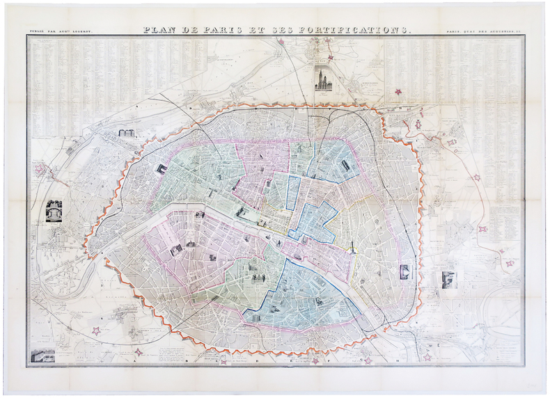
MAILLARD & ALVAR TOUSSAINT (Georges).
Plan de Paris et ses fortifications.
Paris, Aug.te Logerot, [circa 1848]. En 32 sections remises à plat et entoilées, formant un plan de 680 x 985 mm.
Bookseller reference : LBW-5864
|
|
|
MAILLEFER Paul; BIERMANN Charles (intro.):
Géographie illustrée du canton de Vaud.
Lausanne / Neuchâtel, Gazette de Lausanne et Journal suisse / Victor Attinger, 1926. In-4 de VIII + 470 pages, demi-percaline noire à coins, dos muet.
Bookseller reference : 1107

|
|
|
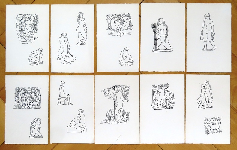
Maillol Aristide:
10 bois gravés en noir.
Gravures tirées par Philippe Gonin, sur les bois d'Aristide Maillol. Dimension des feuilles: environ 13 x 21 cm.
Bookseller reference : 24131
|
|
|
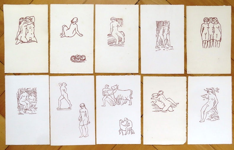
Maillol Aristide:
10 bois gravés sépia.
Gravures tirées par Philippe Gonin, sur les bois d'Aristide Maillol, deux avec de légères rousseurs. Dimension des feuilles: environ 13 x 21 cm.
Bookseller reference : 24132
|
|
|
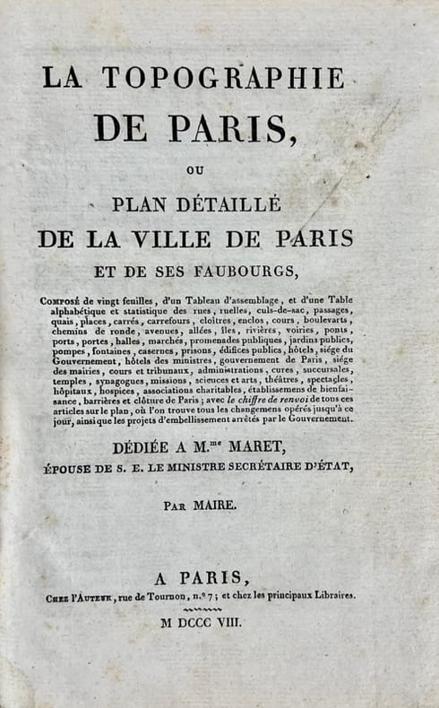
MAIRE (Nicolas).
La Topographie de Paris, ou Plan détaillé de la Ville de Paris et de ses Faubourgs.
A Paris, chez l'Auteur, 1808-1811. In-8 de VII-107-(1) pp. et 22 planches sur double-page, cartonnage de l'époque.
Bookseller reference : 43087
|
|
|
MAIRE (Nicolas).
Nouveau plan itinéraire de la ville de Paris divisé en 12 arr. avec tous les édifices publics.
Paris, J. Goujon, 1824-1826. En 36 sections remises à plat, formant un plan de 572 x 839 mm.
Bookseller reference : LBW-5728

|
|
|
MAIRE, N.
Carte topographique des environs de Paris
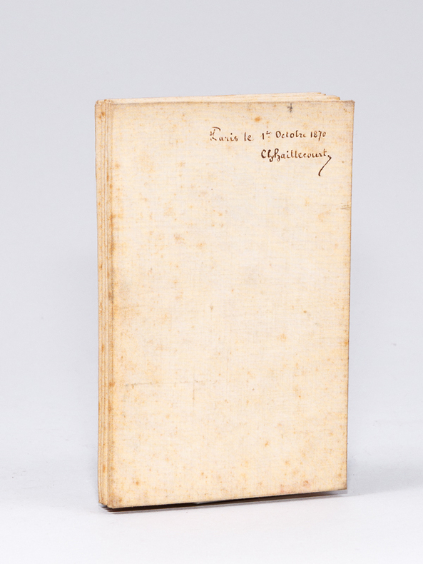
Nouvelle édition, Rectifiée d'après la Nouvelle Carte de France de l'Etat Major, 1 carte dépliante entoilée format 98,8 x 68 cm, J. Andriveau-Goujon, éditeur Rue du Bac n°21 près le Pont-Royal, gravée par Perrier et B. Tardieu, Paris, s.d. [ circa 1850-1865 ], échelle de 5000 mètres ou demi-myriamètre, échelle de 2500 toises divisée par 100, échelle d'une lieue de 2280 toises ou de 25 au degré Bon état (2 petites taches en haut de cartes, mention ms. "Paris le 1er octobre 1870 Ch. Haillecourt" au verso, bon exemplaire par ailleurs). Français

|
|
|
MAIRE, N.
Carte topographique des environs de Paris
Nouvelle édition, Rectifiée d'après la Nouvelle Carte de France de l'Etat Major, 1 carte dépliante entoilée format 98,8 x 68 cm, J. Andriveau-Goujon, éditeur Rue du Bac n°21 près le Pont-Royal, gravée par Perrier et B. Tardieu, Paris, s.d. [ circa 1850-1865 ], échelle de 5000 mètres ou demi-myriamètre, échelle de 2500 toises divisée par 100, échelle d'une lieue de 2280 toises ou de 25 au degré
Bookseller reference : 59427
|
|
|
Mais S P B
Round About England
No marks or inscriptions and no creasing to covers. A very clean very tight copy with bright unmarked red cloth boardsfoxing to page edges and no bumping to corners. 328pp. More travels around Great Britain from London to the Shetlands. Illustrated.

|
|
|
MAISON BASSET.
[ARCHÉOLOGIE] Tableau d'archéologie.
Paris, Maison Basset, [1851]. 493 x 632 mm.
Bookseller reference : LBW-8435

|
|
|
MAJAX Gérard
"Les 100 meilleurs tours de cartes; faciles à faire."
Paris, Fernand Nathan, 1980. "17 x 24, 223 pp., très nombreuses illustrations, cartonnage d'édition imprimé, état moyen (cartonnage légèrement abîmé; pellicule partiellement enlevée)."
Bookseller reference : 36724 ISBN : 2092955012
|
|
|
MAJAX Gérard
Farces magiques pour les fêtes.
Paris, L'Archipel, 1998. 17 x 24, 175 pp., très nombreuses illustrations, broché, très bon état.
Bookseller reference : 36723
|
|
|
Major Raymond H. Fredette; B/w Photographs and Maps Illustrator; Hanson W. Baldwin Foreword; Sir John Slessor Afterword;
The Sky on Fire: The First Battle of Britain 1917-1918 and the Birth of the Royal Air Force 1st Edition
Holt Rinehart and Winston 1/1/1966. Hardcover. Like New. Hardcover and dust jacket. Good binding and cover. Light wear. Clean unmarked pages. Ships daily. Holt, Rinehart and Winston hardcover
Bookseller reference : 1612140045
|
|
|
Major Raymond H. Fredette; B/w Photographs and Maps Illustrator; Hanson W. Baldwin Foreword; Sir John Slessor Afterword;
The Sky on Fire: The First Battle of Britain 1917-1918 and the Birth of the Royal Air Force 1st Edition
Holt Rinehart and Winston 1966-01-01. First Edition. Hardcover. Very Good. First Edition stated. No dust jacket. Gray and orange cloth boards- cloth lightly rubbed at the top edge of the spine. Clean has a good binding no marks or notations. Holt, Rinehart and Winston hardcover books
Bookseller reference : 193708

|
|
|
Makepeace, Chris
Old Ordnance Survey Maps : South Reddish & Brinnington 1904 : Lancashire Sheet 112.05
Mint unused map pp. Map of the South Reddish & Brinnington districts of Stockport on Lancashire sheet No 112.05 from 1904.

|
|
|
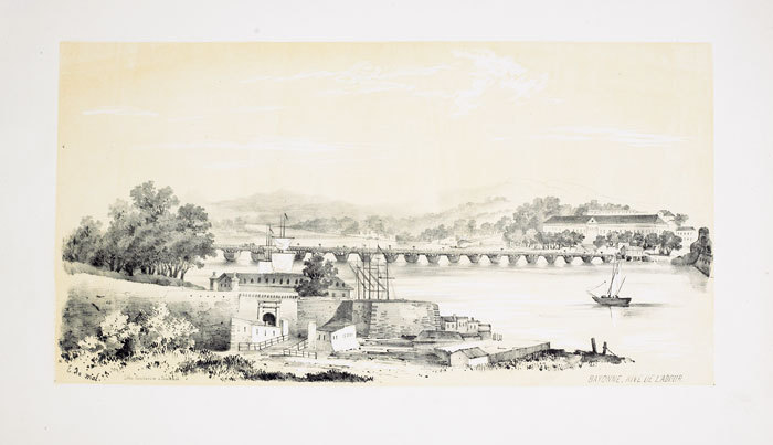
MALBOS (Eugène de);
Bayonne rive de l'Adour.
Toulouse 1843 230 x 440 mm.
Bookseller reference : LBW-652
|
|
|
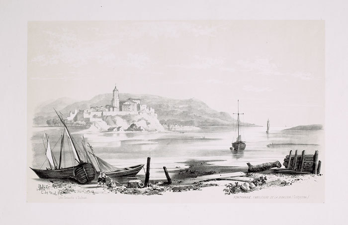
MALBOS (Eugène de);
Fontarabie, embouchure de la Bidassoa (Guipuscoa).
Toulouse 1843 233 x 398 mm.
Bookseller reference : LBW-654
|
|
|
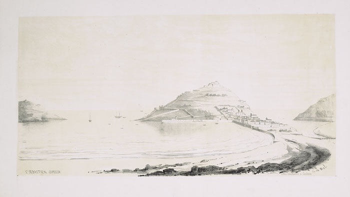
MALBOS (Eugène de);
St. Sebastien, Guipuscoa.
Toulouse 1843 230 x 455 mm.
Bookseller reference : LBW-653
|
|
|
Malka Frères
Jeu de 40 cartes à jouer (enseignes latines)
Malka Frères Cartes à jouer Jeu de 40 cartes à jouer (5,5 x 8,5 cm), étui en papier, enseignes latines (épées, bâtons, coupes, deniers) ; étui papier déchiré, par ailleurs bon état. Livraison a domicile (La Poste) ou en Mondial Relay sur simple demande.
Bookseller reference : dl1378
|
|
|
Malkin Lawrence/Pugliese Paul J. maps
Krueger's Men: The Secret Nazi Counterfeit Plot and the Prisoners of Block 19
NY: Little Brown 2006. 1st printing. VG/VG dust jacket remainder mark. xiv 287 p. photos maps notes biblio appendix index 8vo; Little Brown hardcover
Bookseller reference : 50734 ISBN : 0316057002 9780316057004

|
|
|
 Receive by email
 Download as PDF document
 RSS feed


