|
PopOut Maps
Budapest PopOut Map PopOut Maps
2015-04-01. New. Ships with Tracking Number! INTERNATIONAL WORLDWIDE Shipping available. May be re-issue. Buy with confidence excellent customer service! unknown
Bookseller reference : 1910218049n ISBN : 1910218049 9781910218044

|
|
|
PopOut Maps
Cambridge PopOut Map
Paperback. New. Explore the academic gem of Cambridge with the help of this genuinely pocket-sized pop-up map. Small in size yet big on detail this compact dependable Cambridge city map will ensure you don't miss a thing. Includes a PopOut map featuring detailed street map of the central city area including paperback
Bookseller reference : ria9781910218198_new ISBN : 1910218197 9781910218198
|
|
|
PopOut Maps
Cambridge PopOut Map
Sheet map folded. New. Explore the academic gem of Cambridge with this handy pop-up map. This genuinely pocket-sized PopOut Map features a detailed street map of the central city area including all the colleges. Additional 'What To See.How To Get There' section helps identify all the key points of interest. Ideal to pop in a pocket or bag for quick reference. unknown
Bookseller reference : A9781910218198 ISBN : 1910218197 9781910218198

|
|
|
PopOut Maps
Cambridge PopOut Map PopOut Maps
2016-02-26. New. Ships with Tracking Number! INTERNATIONAL WORLDWIDE Shipping available. May be re-issue. Buy with confidence excellent customer service! unknown
Bookseller reference : 1910218197n ISBN : 1910218197 9781910218198

|
|
|
PopOut Maps
Cambridge PopOut Map PopOut Maps
2016-02-26. Good. Ships with Tracking Number! INTERNATIONAL WORLDWIDE Shipping available. May not contain Access Codes or Supplements. May be re-issue. May be ex-library. Shipping & Handling by region. Buy with confidence excellent customer service! unknown
Bookseller reference : 1910218197 ISBN : 1910218197 9781910218198

|
|
|
PopOut Maps
Cambridge PopOut Map
Paperback. As New. Explore the academic gem of Cambridge with the help of this genuinely pocket-sized pop-up map. Small in size yet big on detail this compact dependable Cambridge city map will ensure you don't miss a thing. Includes a PopOut map featuring detailed street map of the central city area including paperback
Bookseller reference : ria9781910218198_rkm ISBN : 1910218197 9781910218198
|
|
|
Popout Maps
Cape Town Popout Map Popout Maps
Popout Maps. Used - Very Good. Good shape with typical wear. Pages are unmarked and sharp. Paperback Used - Very Good Ships fast! 2011New edition Popout Maps paperback
Bookseller reference : ND-121862 ISBN : 184587885x 9781845878856
|
|
|
Popout Maps
Chicago PopOut Map PopOut Maps
2012-09-03. New. Ships with Tracking Number! INTERNATIONAL WORLDWIDE Shipping available. May be re-issue. Buy with confidence excellent customer service! unknown
Bookseller reference : 1845879090n ISBN : 1845879090 9781845879099

|
|
|
PopOut Maps
Chicago PopOut Map
Sheet map. New. Discover the 'Windy City' of Chicago with the help of this genuinely pocket-sized pop-up map. Small in size yet big on detail this compact dependable city map will ensure you don't miss a thing. Includes two pop-up maps covering north & south Chicago Additional maps covering transit in unknown
Bookseller reference : ria9781910218495_new ISBN : 1910218499 9781910218495
|
|
|
PopOut Maps
Chicago PopOut Map Popout Maps
2018-01-07. Good. Ships with Tracking Number! INTERNATIONAL WORLDWIDE Shipping available. May not contain Access Codes or Supplements. May be re-issue. May be ex-library. Shipping & Handling by region. Buy with confidence excellent customer service! unknown
Bookseller reference : 1910218499 ISBN : 1910218499 9781910218495

|
|
|
PopOut Maps
Chicago PopOut Map Popout Maps
2018-01-07. New. Ships with Tracking Number! INTERNATIONAL WORLDWIDE Shipping available. May be re-issue. Buy with confidence excellent customer service! unknown
Bookseller reference : 1910218499n ISBN : 1910218499 9781910218495

|
|
|
Popout Maps
Chicago PopOut Map PopOut Maps
2012-09-03. Good. Ships with Tracking Number! INTERNATIONAL WORLDWIDE Shipping available. May not contain Access Codes or Supplements. May be re-issue. May be ex-library. Shipping & Handling by region. Buy with confidence excellent customer service! unknown
Bookseller reference : 1845879090 ISBN : 1845879090 9781845879099

|
|
|
PopOut Maps
Chicago PopOut Map
Sheet map. As New. Discover the 'Windy City' of Chicago with the help of this genuinely pocket-sized pop-up map. Small in size yet big on detail this compact dependable city map will ensure you don't miss a thing. Includes two pop-up maps covering north & south Chicago Additional maps covering transit in unknown
Bookseller reference : ria9781910218495_rkm ISBN : 1910218499 9781910218495
|
|
|
Popout Maps
Chicago PopOut Map PopOut Maps
2014-01-04. New. Ships with Tracking Number! INTERNATIONAL WORLDWIDE Shipping available. May be re-issue. Buy with confidence excellent customer service! unknown
Bookseller reference : 1845879988n ISBN : 1845879988 9781845879983

|
|
|
PopOut Maps
Chicago PopOut Map - pop-up city street map of Chicago - folded pocket size travel map with transit map Popout Maps
Compass Maps 2012-06-15. New edition. Paperback. Good. Compass Maps paperback
Bookseller reference : SONG1845879090 ISBN : 1845879090 9781845879099

|
|
|
Popout Maps
Copenhagen PopOut Map: pop-up city street map of Copenhagen city center - folded pocket size travel map with transit map included PopOut Maps
2011-05-09. New. Ships with Tracking Number! INTERNATIONAL WORLDWIDE Shipping available. May be re-issue. Buy with confidence excellent customer service! unknown
Bookseller reference : 1845878795n ISBN : 1845878795 9781845878795

|
|
|
PopOut Maps
Copenhagen PopOut Map
Sheet map folded. New. Step into the Danish capital city of Copenhagen with this handy pop-up map. This genuinely pocket-sized Copenhagen city map includes 2 PopOut maps featuring central Copenhagen and greater Copenhagen as well as a locator map and transit maps. Ideal to pop in a pocket or bag for quick reference while exploring the city. unknown
Bookseller reference : A9781910218631 ISBN : 1910218634 9781910218631

|
|
|
Popout Maps
Copenhagen PopOut Map PopOut Maps
Footprint PopOut Maps. New edition. Map. Used; Good. Simply Brit Shipped with Premium postal service within 24 hours from the UK with impressive delivery time. We have dispatched from our book depository; items of good condition to over ten million satisfied customers worldwide. We are committed to providing you with reliable and efficient service at all times. 09/16/2011 Footprint PopOut Maps unknown
Bookseller reference : 2833460 ISBN : 0711600301179 0711600301
|
|
|
Popout Maps
Copenhagen PopOut Map PopOut Maps
Footprint PopOut Maps 09/16/2011. New edition. Paperback. Used; Good. WE SHIP WITHIN 24 HRS FROM LONDON UK 98% OF OUR ORDERS ARE RECEIVED WITHIN 7-10 DAYS. We believe you will be completely satisfied with our quick and reliable service. All orders are dispatched as swiftly as possible! Buy with confidence! Footprint PopOut Maps paperback
Bookseller reference : 3366961 ISBN : 1845878795 9781845878795
|
|
|
Popout Maps
Copenhagen PopOut Map PopOut Maps
2013-08-01. New. Ships with Tracking Number! INTERNATIONAL WORLDWIDE Shipping available. May be re-issue. Buy with confidence excellent customer service! unknown
Bookseller reference : 1845879554n ISBN : 1845879554 9781845879556

|
|
|
Popout Maps
Dallas PopOut Map PopOut Maps
2013-06-09. New. Ships with Tracking Number! INTERNATIONAL WORLDWIDE Shipping available. May be re-issue. Buy with confidence excellent customer service! unknown
Bookseller reference : 1845879139n ISBN : 1845879139 9781845879136

|
|
|
PopOut Maps
Dubai PopOut Map
Sheet map folded. New. Discover dazzling Dubai - the opulent and ambitious Emirate with year-round sunshine - with this handy genuinely pocket-sized pop-up map. Small in size yet big on detail this compact dependable Dubai city map will ensure you don't miss a thing. unknown
Bookseller reference : A9781910218648 ISBN : 1910218642 9781910218648

|
|
|
Popout Maps
Dubai PopOut Map Footprint PopOut Map
2011-09-16. New. Ships with Tracking Number! INTERNATIONAL WORLDWIDE Shipping available. May be re-issue. Buy with confidence excellent customer service! unknown
Bookseller reference : 1845878868n ISBN : 1845878868 9781845878863
|
|
|
PopOut Maps
Dubai PopOut Map PopOut Maps
2013-03-04. New. Ships with Tracking Number! INTERNATIONAL WORLDWIDE Shipping available. May be re-issue. Buy with confidence excellent customer service! unknown
Bookseller reference : 1845879279n ISBN : 1845879279 9781845879273

|
|
|
Popout Maps
Dubai PopOut Map Footprint PopOut Map
2011-09-16. Good. Ships with Tracking Number! INTERNATIONAL WORLDWIDE Shipping available. May not contain Access Codes or Supplements. May be re-issue. May be ex-library. Shipping & Handling by region. Buy with confidence excellent customer service! unknown
Bookseller reference : 1845878868 ISBN : 1845878868 9781845878863

|
|
|
PopOut Maps
Dublin PopOut Map
Sheet map folded. New. Experience the Irish charm of Dublin with this handy pop-up map. This genuinely pocket-sized Dublin map includes 2 PopOut maps featuring: a street map of central Dublin and an overview map of greater Dublin as well as maps of Temple Bar Phoenix Park and around Dublin. Ideal to pop in a pocket or bag for quick reference while exploring the city. unknown
Bookseller reference : A9781910218471 ISBN : 1910218472 9781910218471

|
|
|
PopOut Maps
Dublin PopOut Map
Sheet map folded. New. Experience the Irish charm of Dublin with this handy pop-up map. This genuinely pocket-sized Dublin map includes 2 PopOut maps featuring: a street map of central Dublin and an overview map of greater Dublin as well as maps of Temple Bar Phoenix Park and around Dublin. Ideal to pop in a pocket or bag for quick reference while exploring the city. unknown
Bookseller reference : A9781910218907 ISBN : 1910218901 9781910218907

|
|
|
Popout Maps Corporate Author
Dublin Popout Map
Compass Maps Ltd 2017. Paperback. New. fol map edition. 3.75x5.00x0.10 inches. Compass Maps Ltd paperback
Bookseller reference : 2-1910218472 ISBN : 1910218472 9781910218471
|
|
|
Popout Maps
Dublin Popout Map Footprint Popout Maps
Footprint Travel Guides. Used - Good. Ships from the UK. Former Library book. Shows some signs of wear and may have some markings on the inside. 100% Money Back Guarantee. Your purchase also supports literacy charities. Footprint Travel Guides unknown
Bookseller reference : GRP113701914 ISBN : 1845878736 9781845878733
|
|
|
PopOut Maps Creator
Dublin PopOut Map PopOut Maps
Pop Out 2017-08-01. Map. Used:Good. Pop Out unknown
Bookseller reference : DADAX1910218472 ISBN : 1910218472 9781910218471
|
|
|
Popout Maps
Dublin PopOut Map PopOut Maps
2011-09-23. Good. Ships with Tracking Number! INTERNATIONAL WORLDWIDE Shipping available. May not contain Access Codes or Supplements. May be re-issue. May be ex-library. Shipping & Handling by region. Buy with confidence excellent customer service! unknown
Bookseller reference : 1845878736 ISBN : 1845878736 9781845878733

|
|
|
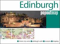
PopOut Maps
Edinburgh PopOut Map
Sheet map folded. New. Uncover the magnificence of Scotland's capital city of Edinburgh with this handy pop-up map. This genuinely pocket-sized Edinburgh map includes a PopOut map featuring the historic city centre as well providing information on the Top 22 sights to see while you're there. Ideal to pop in a pocket or bag for quick reference while exploring. unknown
Bookseller reference : A9781910218853 ISBN : 1910218855 9781910218853
|
|
|
PopOut Maps Creator
Edinburgh PopOut Map PopOut Maps
PopOut Maps 2014-01-02. Map. Used:Good. PopOut Maps unknown
Bookseller reference : DADAX1845879791 ISBN : 1845879791 9781845879792

|
|
|
Popout Maps
Edinburgh & Glasgow PopOut Map PopOut Maps
2014-08-09. New. Ships with Tracking Number! INTERNATIONAL WORLDWIDE Shipping available. May be re-issue. Buy with confidence excellent customer service! unknown
Bookseller reference : 1845879805n ISBN : 1845879805 9781845879808

|
|
|
PopOut Maps Creator
Florence PopOut Map PopOut Maps
Pop Out 2017-05-14. Map. Used:Good. Pop Out unknown
Bookseller reference : DADAX1910218421 ISBN : 1910218421 9781910218426
|
|
|
Popout Maps
Florence PopOut Map PopOut Maps
2011-03-25. Good. Ships with Tracking Number! INTERNATIONAL WORLDWIDE Shipping available. May not contain Access Codes or Supplements. May be re-issue. May be ex-library. Shipping & Handling by region. Buy with confidence excellent customer service! unknown
Bookseller reference : 1845877918 ISBN : 1845877918 9781845877910

|
|
|
PopOut Maps
Florence PopOut Map: Handy pocket size pop up city map of Florence PopOut Maps
2014-02-03. New. Ships with Tracking Number! INTERNATIONAL WORLDWIDE Shipping available. May be re-issue. Buy with confidence excellent customer service! unknown
Bookseller reference : 1845879813n ISBN : 1845879813 9781845879815

|
|
|
PopOut Maps Creator
Frankfurt PopOut Map PopOut Maps
PopOut Maps 2014-10-15. Map. Used:Good. PopOut Maps unknown
Bookseller reference : DADAX1845879945 ISBN : 1845879945 9781845879945

|
|
|
PopOut Maps
Geneva PopOut Map PopOut Maps
2012-01-09. New. Ships with Tracking Number! INTERNATIONAL WORLDWIDE Shipping available. May be re-issue. Buy with confidence excellent customer service! unknown
Bookseller reference : 1845878981n ISBN : 1845878981 9781845878986

|
|
|
Popout Maps Creator
Geneva Popout Map
Compass Maps Ltd 2019. Paperback. New. fol map edition. 4.00x5.00x0.25 inches. Compass Maps Ltd paperback
Bookseller reference : __1910218685 ISBN : 1910218685 9781910218686
|
|
|
PopOut Maps
Geneva PopOut Map PopOut Maps
2016-02-03. New. Ships with Tracking Number! INTERNATIONAL WORLDWIDE Shipping available. May be re-issue. Buy with confidence excellent customer service! unknown
Bookseller reference : 1910218286n ISBN : 1910218286 9781910218280

|
|
|
PopOut Maps
Glasgow PopOut Map PopOut Maps
2017-03-01. New. Ships with Tracking Number! INTERNATIONAL WORLDWIDE Shipping available. May be re-issue. Buy with confidence excellent customer service! unknown
Bookseller reference : 1910218375n ISBN : 1910218375 9781910218372

|
|
|
Popout Maps
Glasgow PopOut Map Popout Maps
2011-09-16. Good. Ships with Tracking Number! INTERNATIONAL WORLDWIDE Shipping available. May not contain Access Codes or Supplements. May be re-issue. May be ex-library. Shipping & Handling by region. Buy with confidence excellent customer service! unknown
Bookseller reference : 1845878930 ISBN : 1845878930 9781845878931

|
|
|
Popout Maps
Hamburg Popout Map Footprint PopOut Maps
2012-09-02. New. Ships with Tracking Number! INTERNATIONAL WORLDWIDE Shipping available. May be re-issue. Buy with confidence excellent customer service! unknown
Bookseller reference : 1845879066n ISBN : 1845879066 9781845879068

|
|
|
Popout Maps
Hamburg Popout Map Footprint Popout Maps
Footprint Handbooks 2012-04-01. New edition. Paperback. Good. Footprint Handbooks paperback
Bookseller reference : SONG1845879066 ISBN : 1845879066 9781845879068
|
|
|
PopOut Maps
Hong Kong PopOut Map PopOut Maps
2011-01-03. Good. Ships with Tracking Number! INTERNATIONAL WORLDWIDE Shipping available. May not contain Access Codes or Supplements. May be re-issue. May be ex-library. Shipping & Handling by region. Buy with confidence excellent customer service! unknown
Bookseller reference : 1845877683 ISBN : 1845877683 9781845877682

|
|
|
PopOut Maps
Hong Kong PopOut Map PopOut Maps
2014-03-04. New. Ships with Tracking Number! INTERNATIONAL WORLDWIDE Shipping available. May be re-issue. Buy with confidence excellent customer service! unknown
Bookseller reference : 1845879929n ISBN : 1845879929 9781845879921

|
|
|
Popout Maps
InsideOut: London Travel Guide: Pocket size London Travel Guide with two pop-up maps
Hardback. New. London has to be the liveliest most enticing most entertaining most cosmopolitan city on Earth. Whether it's for the sightseeing or the shopping the cuisine or the nightlife let InsideOut London be your guide. This pocket-size London travel guide which includes 2 award-winning PopOut Maps is the perfect guide for any short break. hardcover
Bookseller reference : A9781845879679 ISBN : 1845879678 9781845879679

|
|
|
PopOut Maps
InsideOut: London Travel Guide : Pocket size London Travel Guide with two pop-up maps
Hardback. New. London Travel Guide - see the city insideout with this handy pocket size city guide The ultimate London guide book! London has to be the liveliest most enticing most entertaining most cosmopolitan city on Earth. 2500 years in the making it has everything the modern traveller could possibly want hardcover
Bookseller reference : ria9781845879679_new ISBN : 1845879678 9781845879679

|
|
|
PopOut Maps
Insideout: Rome Travel Guide: Handy Pocket Size Guide to Rome with 2 Pop-out Maps
2014-05-09. New. Ships with Tracking Number! INTERNATIONAL WORLDWIDE Shipping available. May be re-issue. Buy with confidence excellent customer service! unknown
Bookseller reference : 1845879732n ISBN : 1845879732 9781845879730

|
|
 Receive by email
 Download as PDF document
 RSS feed


