|
Schreiber, Georg
Chorographia Territorii Naumburgo-Citiensis. Episcopatus olim nomine celebris una cum magna Consiniorum parte exactissime designata a Ioh. Georg Schreibero. Edita curis et impensis Homannianorum Heredum. Norib: A MDCCXXXII. Cum Privilegio. [Altkolorierter Original-Kupferstich / original colored copper engraving].
o.J. Johann George Schreiber (auch Johann Georg Schreiber, geboren am 10. Dezember 1676 in Spremberg, Oberlausitz, gestorben am 31. Juli 1750 in Leipzig. Deutscher Kupferstecher, Kartograph und erster deutsche Kartenverleger im Kurfürstentum Sachsen. [4 Warenabbildungen]
Bookseller reference : 12035DB

|
|
|
Schroeder William maps and Helmut T. Huebert text
Mennonite Historical Atlas
Winnipeg Canada: Springfield Publishers 1990. Book. Near Fine. Soft cover. 1st Edition. 4to - over 9�" - 12" tall. Stiff green wraps lettered in white. Minor handling wear. Former owner's signature/date inked inside front cover otherwise unmarked. Square uncreased binding. 2nd ptg.: Mar. 1991. viii134 pp. Springfield Publishers Paperback
Bookseller reference : 049987 ISBN : 0920643035 9780920643037
|
|
|
Schuman Frederick; maps by George Brodsky
Design for Power: The Struggle for the World
Knopf. 1942. Hardcover. UsedGood. Hardback fading soiling to cloth; small corner bumps light edge wear; co ntents in good condition with clean text firm binding. . Knopf hardcover
Bookseller reference : 61144
|
|
|
Schuman Frederick L.; George D. Brodsky maps
International Politics The Destiny of the Western State System
Mcgraw-Hill. Very Good with no dust jacket. 1948. Fourth Edition; Second Printing. Hardcover. Light rubbing and toning brief soil to page edges name label on front pastedown small numerical notations on the title page. International shipping billed at cost. ; 8vo 8" - 9" tall; 1025 pages . Mcgraw-Hill hardcover
Bookseller reference : 83076
|
|
|
Schuman Frederick L. Illustrated with Fifty Maps By George D. Brodsky
International Politics; the Western State System and the World Community Sixth Edition
New York New York U.S.A.: McGraw-Hill 1958. Very Good 6th Edition Stated Hard Cover No DJ 745 pages index 50 maps by George D. Brodsky Binding is solid corners slightly bumped and rubbed slight wear to head and tail of spine small black stain at front edge of bottom edge does not affect text no owner information gift messages store stamps remaimder marks or moisture damage pages are clean no marks to text. Will gift wrap no charge just state the occasion. 6th Edition. Hard Cover. Very Good/No Jacket. 8vo - over 7�" - 9�" tall. McGraw-Hill Hardcover
Bookseller reference : 000568
|
|
|
Schupp, Stefanie
Architekturstadtplan Hamburg. Mit Register nach Epochen, Gebäudetypen, Architekten, Strassen.
(Berlin), Verlagshaus Braun, (2004). 2 mehrfach gefalt. farb. Pläne, beidseitig bedruckt Gesamtplan im Maßstab 1:20000, verso Innenstadt im Maßstab 1:8000 sowie 103 S. Register (dt./engl.). Deckel 10,5 x 25 cm. Stärkerer OKart.
Bookseller reference : 81261

|
|
|
Schweidnitz:
Schweidnitz. "Plan der Belagerung der Vestung Schweidnitz in Schlesien im Jahr 1762". Belagerungsplan von Schweidnitz. Kupferstich mit farbigen Truppenaufstellungen aus "Neues Kriegs-Theater ...", No. 49.
Format: 18 x 29,5 cm. *Leicht gebräunt, insgesamt gut erhalten. Landkarten de
|
|
|
Schütt, Ernst Christian (Hrsg.)
Hamburg in historischen Stadtplänen. Die Entwicklung der Stadt seit dem 16. Jahrhundert. Kommentiert von Joachim W. Frank.
(Berlin), Argon, (1995). 18 S. Textheft und 6 mehrf. gefalt. tls. farb. Plänen. 4to. 34,5 cm. Zusammen in OKart.-Mappe. in OPp.-Schuber.
Bookseller reference : 39664

|
|
|
SCIUTO Giovanni
LE GUIDE DES REUSSITES 30 jeux inédits et leurs significations
1989 cartonné noir éditeur (hard-back percale editor) grand in-octavo, premier plat illustré en couleurs (front cover illustrated in colours), illustrations : bien documenté (well-documented), 277 pages, 1989 à Paris France Loisirs,
Bookseller reference : 9358
|
|
|
SCOTT Robert H.
CARTES DU TEMPS et AVERTISSEMENTS DE TEMPÉTES.
1879 Par Robert. H. Scott, M.A.F.R.S. traduit de l'anglais par MM. Zurcher et Margollé. Paris, Gauthier - Villars, 1879. Cartes et tableaux hors texte. In 8° de 155 pp. reliure demi-basane lit de vin, titre doré au dos. Quelques rousseurs, sinon très bon état.
Bookseller reference : 41
|
|
|
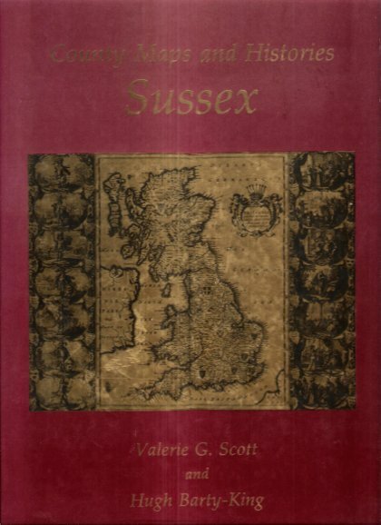
SCOTT Valerie G. , BARTY-KING Hugh
County Maps and Histories Series SUSSEX
Londres Quiller Press 1985 in-4° Nombreuses cartes couleurs et noir et blanc .- 34 p. , 550 gr.
Bookseller reference : 023474
|
|
|
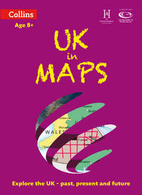
Scoffham Stephen/ Collins Maps
UK in Maps Collins Primary Atlases
Collins 2019. Paperback. New. second edition edition. 56 pages. 12.25x9.00 inches. Collins paperback
Bookseller reference : __0008271739 ISBN : 0008271739 9780008271732
|
|
|
Scoffham Stephen Collins Maps
Uk In Maps
Harpercollins Publishers 2014. Paperback. New. 56 pages. Harpercollins Publishers paperback
Bookseller reference : 2-0007524765 ISBN : 0007524765 9780007524761

|
|
|
Scoffham Stephen & Collins Maps
UK in Maps Collins Primary Atlases
Collins. Paperback. Used; Good. Simply Brit Shipped with Premium postal service within 24 hours from the UK with impressive delivery time. We have dispatched from our book depository; items of good condition to over ten million satisfied customers worldwide. We are committed to providing you with reliable and efficient service at all times. 02/13/2014 Collins paperback
Bookseller reference : 3046521 ISBN : 0007524765 9780007524761
|
|
|
Scoffham Stephen Collins Maps
UK in Maps
Collins. Used - Good. Ships from the UK. Former Library book. Shows some signs of wear and may have some markings on the inside. 100% Money Back Guarantee. Your purchase also supports literacy charities. Collins unknown
Bookseller reference : GRP102697122 ISBN : 0007524765 9780007524761
|
|
|
Scoffham Stephen & Collins Maps
World Atlas Collins Keystart
Collins. New School edition. Paperback. Used; Good. Simply Brit Shipped with Premium postal service within 24 hours from the UK with impressive delivery time. We have dispatched from our book depository; items of good condition to over ten million satisfied customers worldwide. We are committed to providing you with reliable and efficient service at all times. 04/02/2009 Collins paperback
Bookseller reference : 1669039 ISBN : 0007300506 9780007300501

|
|
|
Scoffham Stephen/ Collins Maps
World in Maps Collins Primary Atlases
Collins 2019. Paperback. New. second edition edition. 56 pages. 12.25x9.00 inches. Collins paperback
Bookseller reference : __0008271755 ISBN : 0008271755 9780008271756

|
|
|
SCOTO Francesco (1548 - 1622)
Roma
Pianta a proiezione obliqua della città tratta da "Itinerario, overo nova descrittione de' viaggi principali d'Italia […] di Francesco Scoto" edito a Venezia da Pietro Brigonci nel 1665. "Piazza Navona è posta in bella evidenza con l'obelisco trovata nel Circo di Massenzio e fatto innalzare durante il pontificato di Innocenzo X al centro della fontana dei Fiumi del Bernini, inaugurata nel 1651, ma evidentemente già in corso di realizzazione nel 1650. Manca invece la chiesa di Sant'Agnese in Agone (1652/57) e il colonnato di San Pietro (1656/57)" [cfr. Marigliani p. 209]. Le tavole pubblicate da Brigonci sono riconoscibili dal formato quadrato delle stampe.La sua prima edizione dell'Itinerario d'Italia fu nel 1665 ed aveva il testo ripreso dalla pubblicazione del Cadorin del 1659 la quale ampliava il racconto al Friuli, alla Sicilia, a Malta, al Lazio e alla Terrasanta, quindi nello stesso anno in una ristampa inseriva anche delle tavole su questi territori.Nel 1670, 1673, 1676 e 1679 si collocano le altre edizioni del Brigonci, tutte veneziane, tutte col titolo immutato "Itinerario, overo nova descrittione de' viaggi principali d'Italia […] di Francesco Scoto", tutte arricchite da poco meno di quaranta stampe antiche con vedute di città.Incisione in rame, in buono stato di conservazione. Bibliografia Marigliani (2007) p. 209, n. 115. An oblique projection map of the city taken from "Itinerario, overo nova descrittione de' viaggi principali d'Italia [...] di Francesco Scoto" published in Venice by Pietro Brigonci in 1665. "Piazza Navona is prominently displayed with the obelisk found in the Circus of Maxentius and erected during the pontificate of Innocent X at the centre of Bernini's Fountain of the Rivers, inaugurated in 1651, but evidently already under construction in 1650. The church of Sant'Agnese in Agone (1652/57) and the colonnade of St. Peter's (1656/57) are instead missing'. [cf. Marigliani p. 209]. The plates published by Brigonci can be recognised by the square format of the prints. His first edition of the Itinerary of Italy was in 1665 and had the text taken from Cadorin's publication of 1659, which extended the story to Friuli, Sicily, Malta, Latium and the Holy Land, and in the same year a reprint also included plates on these territories. In 1670, 1673, 1676 and 1679 there were other editions by Brigonci, all Venetian, all with the unchanged title "Itinerario, overo nova descrittione de' viaggi principali d'Italia [...] di Francesco Scoto", all enriched with just under forty antique prints with views of cities. Copper engraving, in good condition. Literature Marigliani (2007) p. 209, n. 115.

|
|
|
SCOTT COUNTY IOWA MAPS BY SCHMIDT & HUEBINGERS
SCOTT COUNTY IOWA MAPS BY SCHMIDT & HUEBINGERS
EVANSVILLE IN1975: UNIGRAPHIC INC 1975. Hard cover. Good. No dust jacket. Signed by previous owner. WATER STAIN ON BACK COVER INSIDE LOWER EDGE &-FEW PAGES. 103 p. REPRODUCTION PUBLISHED IN 1975-SCHMIDT AND HUEBINGER'S MAP OF SCOTT COUNTY IOWA-HARDCOVER-235 PAGES OF ATLAS OF SCOTT COUNTY CONTAINING MAPS OF VILLAGES-CITIES-AND TOWNSHIPS OF THE COUNTY DAVENPORT CITIZENS SCOTT COUNTY HISTORY FARMERS & BUSINESS DIRECTORY & GENERAL INFORMATION & INDEX OF NAMES. - AND OLD AD'S.1882 & 1905-DATE. CONDITION GOOD FAIR= WATER STAIN ON BACK COVER INSIDE LOWER EDGE. INSIDE PAGES GOOD. BOOK SIZE 14" X 11 UNIGRAPHIC INC hardcover
Bookseller reference : Alibris.0027615
|
|
|
Scott Stallard
Title: The Beauty of Bermuda (Signed By Author)
Signed 'Scott Stallard' to title page. No other marks or inscriptions. A lovely clean very tight copy with bright unmarked boards and no bumping to corners. Dust jacket not price clipped or marked or torn or creased with minor traces of storage. pp. Lavishly illustrated book with 117 mainly full-page coloured photographs of Bermuda and an introduction by Peter Benchley.

|
|
|
Scott, Cameron: Editor
Nanaimo Magazine, June 1993 - Gabriola Island Diving Photo on Cover
46 pages. Features: Nice photo of Harleys in front of the Queen's; Beachcombing - photo-illustrated article by Dave Drexhage; Hiking - photo-illustrated article by Jean Macleod le Cheminant - with maps of local hiking destinations; Sanctuary of the Sea - Gabriola Pass may harbour one of Canada's first Marine Reserves - photo-illustrated article by Iain Cuthbert; Nice photo ad for the ill-fated Pacliacchi's Restaurant in the old downtown firehall features photo outside the restaurant with dozens of supporters; Dozens of ads for local small businesses; and more. Moderate wear. Unmarked. A sound copy. Book

|
|
|
Scott, Munroe; McClure, Robert (Signed)
McClure : The China Years of Dr. Bob McClure *SIGNED BY SUBJECT*
409 pages. Dr. McClure's attractive signature upon half-title page. "This book started out to be a full biography of Dr. Bob McClure from his birth in 1900 up to the present time. It gradually transformed itself into something that may seem to fall halfway between an adventure story and a history of China through the first half of the twentieth century." - from Foreward. Prior owner's neatly written gift greetings upon half-title page which has a small piece cleanly clipped from top corner. Maps printed upon endpapers. Contents clean and unmarked. Light wear. Excellent copy. Book
|
|
|
Scott, Schomberg
Culzean : a History and Guidebook
No marks or inscriptions to contents. No creasing to covers. A very clean very tight copy with bright unmarked silightly rubbed boards, staples not rusted and no bumping to corners. 68pp. Culzean in the province of Carrick in South Ayrshire became the stronghold of the Kennedy clan whose roots go back to the 12th century. First edition, second printing. We do not use stock photos, the picture displayed is of the actual book for sale. Every one of our books is in stock in the UK ready for immediate delivery.

|
|
|
Scott-Elliot, W.
THE STORY OF ATLANTIS. A Geographical, Historical, and Ethnological Sketch. With a Preface by A. P. Sinnett.
pp. xiii, 87. Four colored folding maps of the World's Configuration. 8vo. Original full cloth binding. Joints detached. Old water spotting not affecting text. This edition was first issued in 1909. Scarce. **PRICE JUST REDUCED! OCC 6
|
|
|
SCULPTURE MONDIALE par André MALRAUX.
Le musée imaginaire de la sculpture mondiale volume 2 : des bas-reliefs aux grottes sacrées. Richement documenté (planches en couleurs, héliogravures, cartes).
Ed. Gallimard 1954 (coll. la Galerie de la Pléiade). Bel exemplaire relié, reliure pleine toile ornée et jaquette d'éd., gd et fort in-8, 512 pages + planches.
Bookseller reference : AUB-6203
|
|
|
Scultetus, Bartholomäus
Misniae Et Lusatiae Tabula. Um 1600. Descripta à M. Bartholomaeo Sculteto Gorlit. Mark Meißen & Lausitz. [Altkolorierter Kupferstich, gerahmt].
o.J.
Bookseller reference : 66483CB
|
|
|
SEACHART SCOTLAND - JOHN MARR, JOHN THORNTON.
A New Description of the East Coast of Scotland from Berwick to Bokannais: Wherein is fully shewed the Chief Forelands, Bays, Roads, Rivers, Havens, Creeks, Sands, Shoals, Depths of Water and Anchoridg, with the Course of the Tides, and what Moon make...
(London, ca. 1810). Folio. (45 x 28 cm.). Later hcloth. Gilt lettering on upper cover. 4 pp. in folio. + engraved map (44 x 52 cm.) Chart of the East Coast of Scotland Bu John Thornton. Left and right margins shaved (no loss of image). Light browning and a few brownspots.
Bookseller reference : 55309
|
|
|
SEACHART SCOTLAND - JOHN MARR, JOHN THORNTON.
A New Description of the East Coast of Scotland from Berwick to Bokannais: Wherein is fully shewed the Chief Forelands, Bays, Roads, Rivers, Havens, Creeks, Sands, Shoals, Depths of Water and Anchoridg, with the Course of the Tides, and what Moon make...
(London, ca. 1810). Folio. (45 x 28 cm.). Later hcloth. Gilt lettering on upper cover. 4 pp. in folio. + engraved map (44 x 52 cm.) Chart of the East Coast of Scotland Bu John Thornton. Left and right margins shaved (no loss of image). Light browning and a few brownspots.
|
|
|
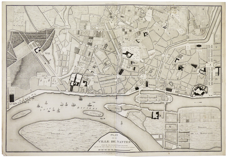
SEBIRE (J.) & COULON.
[NANTES] Plan de la ville de Nantes.
Nantes, Sebire, et Paris, Coulon, An 3. de la Rép. Fr. [1795]. 490 x 707 mm.
Bookseller reference : LBW-5910
|
|
|
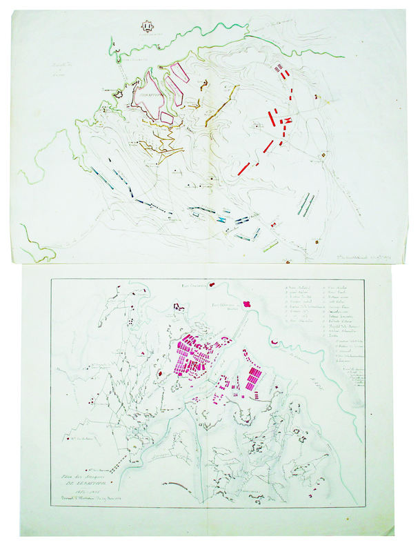
SEBASTOPOL. MANUSCRIT.
[Plan du siège de Sébastopol] [et] Plan des attaques de Sébastopol.
1854-1855. 272 x 422 mm et 288 x 386 mm, sur papier fin.
Bookseller reference : LBW-4226
|
|
|
SEBE Alain
ALGER : CARTES POSTALES ANCIENNES.
L'Harmattan, 1994. In-8 broché, 111 pages, album illustré de reproductions de cartes postales anciennes. Bel exemplaire, état neuf.
Bookseller reference : 5532
|
|
|
SEBASTIAN MÜNSTER, (Map-maker), (1488-1552).
[HAND-COLOURED MAP of ASIA MINOR by MÜNSTER] Von den Landern Asie.
Very Good German Original hand-colored map. 4to. 27x19 cm, with cartoon frame: 40x30 cm. A decorative small map of Asia Minor, from east to the Euphrates, South to the Mediterranean, North to the Black Sea and including Thracia (Thrace). It shows Thracia, Bithynia, Pontus, Paphlagonia, Galatia, Phrygia Minor, Mysia, Phrygia Maior, Lydia, Ionia, Ephesos, Meandros, Lycus [Valley], Caria, Lycia, Pamphylia, Cilicia, Lycaoni, Pisidia, Argos Mt., Taurus Mt., Sebastia, Cappadocia, Armenia, Syria, Nicopolis. Seas decorated with sea monsters. The land filled with mountains. "Münster's Cosmography was one of the most influential geographical works of the 16th Century. It was published in a number of editions over a half century and was continuously revised and updated to include new illustrations and updated information. Sebastian Münster (1488-1552) was a cosmographer and professor of Hebrew who taught at Tübingen, Heidelberg, and Basel. He settled in the latter in 1529 and died there, of plague, in 1552. As a young man, Münster joined the Franciscan order and studied philosophy in Heidelberg. He also studied geography and mathematics in Loewen, as well as Hebrew at Freiburg. In 1512, he was ordained as a priest and taught philosophy and theology at Tübingen from 1514 to 1518. While in Tübingen, he also conducted further studies in geography. He moved to Basel in 1518 and published a Hebrew grammar, one of the first books in Hebrew published in Germany. In 1521 Münster moved again, back to Heidelberg, where he continued to publish Hebrew texts and the first German-produced books in Aramaic. After converting to Protestantism in 1529, he took over the chair of Hebrew at Basel, where he published his main Hebrew work, a two-volume Old Testament with a Latin translation. Münster made himself the center of a large network of scholars from whom he obtained geographic descriptions, maps, and directions. He published his first known map, a map of Germany, in 1525. Three years later, he released a treatise on sundials. In 1540, he published Geographia universalis vetus et nova, an updated edition of Ptolemy's Geographia. In addition to the Ptolemaic maps, Münster added 21 modern maps. One of Münster's innovations was to include one map for each continent, a concept that would influence Ortelius and other early atlas makers. The Geographia was reprinted in 1542, 1545, and 1552. Münster is best known today for his Cosmographia universalis, the first German-language description of the world. It was first published in 1554 and contained 471 woodcuts and 26 maps over 6 volumes. Many of the maps were taken from the Geographia and modified over time. It was released in at least 46 editions in 6 languages by 1650, with 21 German editions alone. The Cosmographia was widely used in the sixteenth and seventeenth centuries and the text, woodcuts, and maps all influenced geographical thought for generations.".
|
|
|
SEDAN
Carte au 1/200 000e. Sans date.
Une feuille 32x50 cm.
|
|
|
Seeger Maps
Ozaukee Co. WI
Seeger Maps. Used - Good. Shows some signs of wear and may have some markings on the inside. Seeger Maps unknown
Bookseller reference : GRP68037819 ISBN : 1890552895 9781890552893
|
|
|
SEGHERS (Willem).
[PROPAGANDE FASCISTE] [Invasion de l'Éthiopie par Mussolini].
Anvers, Patria N.V., [circa 1935]. Lithographie en couleurs de 824 x 561 mm.
Bookseller reference : LBW-8330

|
|
|
SEGUIN Jean-Pierre - JANDIN Cécile de - GOURDON Marie-Thérèse
Cartes à jouer - Donation faite à la Bibliothèque Nationale par Monsieur Paul Marteau, maître-cartier, juin 1966
Bibliothèque Nationale, 1966, broch. gr. in-8 (19 x 26,5), 44 p., avant-propos de Etienne Dennery, avertissement de Jean Adhémar, gravures in-t., avec son carton d'invitation, tampon sur la couverture, bon état.
Bookseller reference : QWA-19411

|
|
|
SEGUIN Jean-Pierre
Le jeu de carte.
Paris: Hermann, 1968 pet. in-4, 346 pages, riche illustration, bibliographie. Reliure toile, jaquette avec pet. marques.
Bookseller reference : 1238024
|
|
|
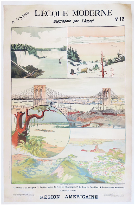
SEIGNETTE (Adrien) & LUNOIS (Alexandre).
L'École moderne. Géographie par l'aspect. N°12. Région américaine.
Paris, Paul Dupont, [1900]. 1,22 x 0,85 m ; montée sur toile.
Bookseller reference : LBW-7872
|
|
|
SELF INSTRUCTOR.
The Self Instructor, or, Young Man's Best Companion; being an Introduction to all the various branches of useful Learning and Knowledge. Containing Writing, Grammar, Arithmetic, Astronomy, Geography, Chronology, and Miscellaneous Articles. To which is added, The Artist's Assistant; comprising the Arts of Drawing, Perspective, Etching, Engraving, Mezzotinto, Scraping, Painting, Drying, Colouring of Maps, etc. A brief account of Naval and Military Affairs. Also, various useful Medicinal Receipts.
8vo (218 x 135 mm), [4], 593, [3] pp., 3pp. of contents at end, folding engraved map of the world before the engraved and printed titles, 7 engraved plates, contemporary tree calf, spine gilt, morocco label, a nice copy. The map and the engraved frontispiece are "Published by Nuttall, Fisher, & Co., Liverpool, Sept. 1814, and Aug. 1815", respectively.
|
|
|
Seltzer Leon
THE COLUMBIA LIPPINCOTT GAZETTEER OF THE WORLD with 1961 Supplement
New York: Columbia University Press 1962. pp. x 2148 22. thumb indexed. Original brown cloth binding very good with slight wear only. Contents clean and tight no inscriptions. a very good clean tight copy. Please note: This is a substantial volume and a small shipping surcharge is likely. Second Printing. Hard Cover. Very Good. 4to. Columbia University Press Hardcover
Bookseller reference : 008077
|
|
|
Selwyn, Victor
Plan Your Route: The New Approach to Map Reading
Good+ Hardback with good+ dust jacket. Including the electronic technology and satellite navigation. Minor shelf wear. Corners of boards have been knocked very slightly. Clean text. Black & white/colour illustrations. 196p.
|
|
|
SELZ
Carte allemande au 1/80 000?. Fin XIXe.
1 feuille repli?e. 31,5x45 cm.
|
|
|
SEMPÉ
Sempe : A question of balance
2006, Phaidon Press, coffret cartonné toilé contenant 23 cartes postales sur le thème du vélo (dessins et aquarelles) - manque 1 carte postale | Etat : bon, coffret défraîchi, cartes postales en très bon état, manque 1 carte postale (Ref.: ref98251)
Bookseller reference : 9782845233112
|
|
|
SEMIR, Ramon de
MAPA DE VALL FERRERA - 1951
Edit. Con. Sup. Geográfico, 1951. Mapa topográfico excursionista. 1:37.500. Mapa entelado y plegado. Firma antiguo proopietario. Muy buen ejemplar.
|
|
|
SEMIR, Ramon de
RIBAGORÇA. Llauset. Mulleres. Beciberri. Fenarroi - Granollers 1961 - Mapa
Granollers, Editorial Alpina, 1961. Mapa topográfico excursionista. Escala 1:25.000. Mapa entelado y plegado. Muy buen ejemplar.
|
|
|
SEMUR
Carte routi?re de l'arrondissement de Semur (C?te d'Or) au 1/50 000e. Sans date.
Une feuille 64x49 cm. Plis r?par?s.
|
|
|
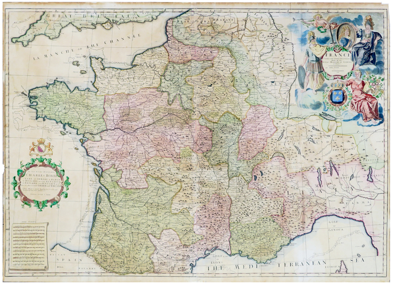
SENEX (John).
France corrected from ye observations made by the Royal Academy of Sciences at Paris.
1708. 635 x 918 mm.
Bookseller reference : LBW-5811
|
|
|
Senecal, C.O.; Yorston, R.B.; Faribault, E.R.
Province of Nova Scotia, Halifax County (City of Halifax Sheet, No. 68)
Approx. 27" x 19". Library markings. Faint discolouration to upper right corner. Map

|
|
|
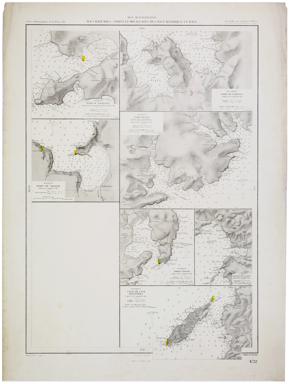
SERVICE HYDROGRAPHIQUE DE LA MARINE.
[BALÉARES] Îles Baléares. Ports et mouillages des îles Majorque et Ivice.
1892-1911. 647 x 434 mm.
Bookseller reference : LBW-5435
|
|
|
SERVICE HYDROGRAPHIQUE DE LA MARINE.
[CEYLAN/SRI LANKA] Ile de Ceylan. Port de Colombo et ses approches.
Paris, 1888. 615 x 441 mm.
Bookseller reference : LBW-2417

|
|
 Receive by email
 Download as PDF document
 RSS feed


