|
Solé:
Elephant Woman.
P.M.J éditions. Carte postale, à l'état de neuf.
Bookseller reference : 972

|
|
|
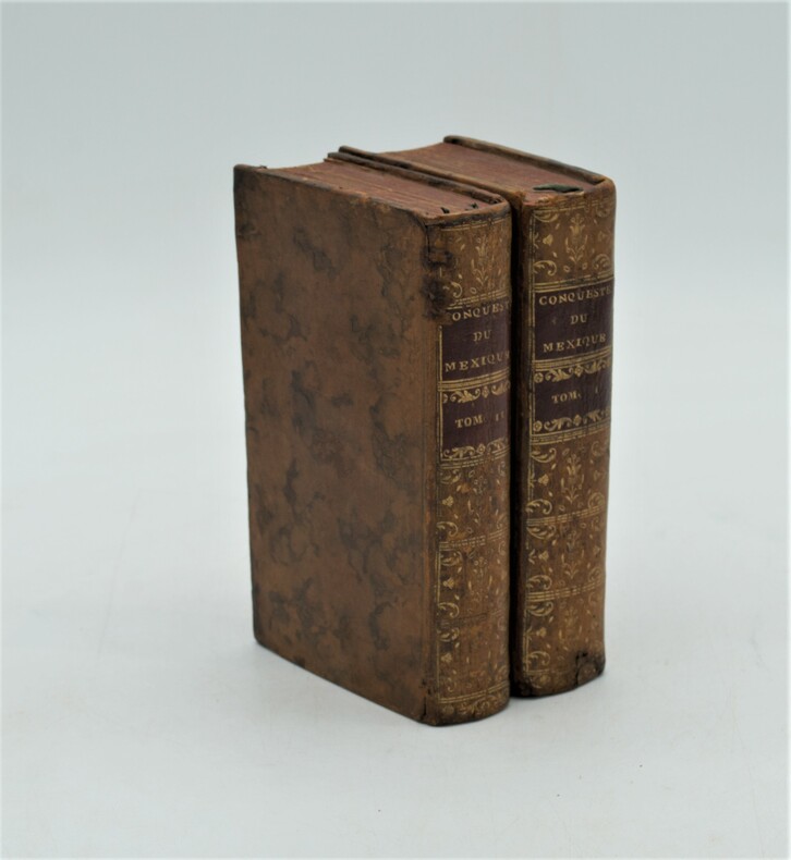
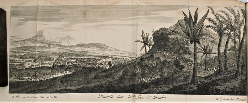
SOLIS (Antoine de).
Histoire de la Conqueste du Mexique, ou de la Nouvelle Espagne, par Fernand Cortez, traduite de...par l'Auteur du Triumvirat. Cinquième édition .
Paris, Compagnie des Libraires, 1730 ; 2 volumes in-12 de 15 ffnch., 606 pp., 13 ffnch., 6 ffnch., 560 pp.,12 ff. Et illustré de 2 cartes ( Golfe du Mexique et environs du lac du Mexique) et 11 planches ,la plupart dépliantes (Vue du Rio de Canoas, l'Ile de Cuba au port St Jacques, vaisseaux de Cortez désagréés sur une plage, bataille dans la vallée d'Otumba, vue de Mexico, etc..), relié plein basane marbré , dos lisse orné avec pièces de titre et tomaison rouge , tranches rouges , quelques petits accidents et restaurations aux reliures , petit manque de papier au titre du tome 1 sans atteinte.
Bookseller reference : PHO-1238
|
|
|
SOLIS, DON ANTOINE DE.
Histoire de La Conquête du Mexique, ou de la Nouvelle Espagne, traduite de l’espagnol de Don Antoine de Solis
Paris, Jean Bouillerot, 1691. Édition originale in-4° (25x19,5cm), 16ff.-630pp.-12ff. , illustré de 2 cartes et 12 planches , la plupart dépliantes , relié plein veau époque , dos à nerfs orné avec titre , restauration au dos , mouillure en fin d’ouvrage.
Bookseller reference : PHO-1239
|
|
|
Sonnichsen CL./Bufkin Donald H. maps C. L.
Tucson: the Life and Times of an American City
Norman: University of Oklahoma Press 1987. 1st paperback printing. VG. xiv 369 p. photos map notes biblio index large 8vo wraps; University of Oklahoma Press paperback
Bookseller reference : 15841 ISBN : 0806120428 9780806120423

|
|
|
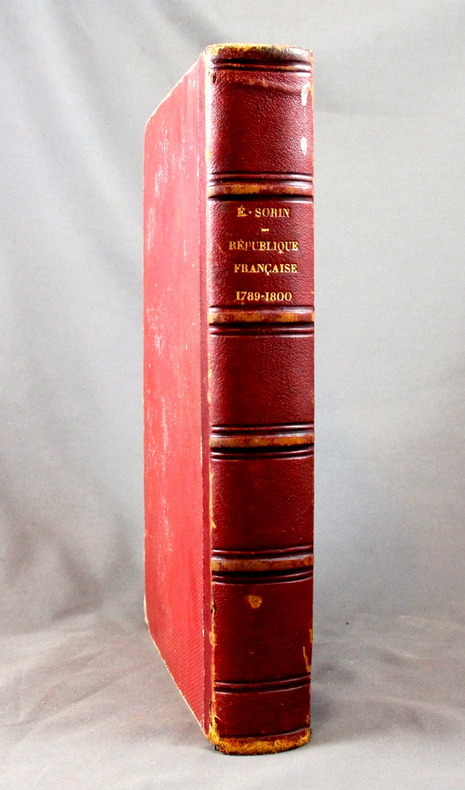
SORIN Elie:
Histoire de la République française. 1789-1800.
Paris, F. Polo, 1873. In-4 de 796 pages, demi-basane rouge, dos à nerfs orné à froid. Dos et coiffes frottés, léger accroc à la coiffe inférieures, rousseurs.
Bookseller reference : 1646
|
|
|
SORIN J.
Rapport sur la carte historique et arch?ologique de l'Anjou de M. La Bessi?re, instituteur primaire ? St-Georges-sur-Loire. Article (6 pages) dans le Bulletin de la Socoi?t? Industrielle d'Angers.
Num?ro complet.
|
|
|
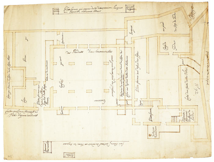
SOSPEL. MANUSCRIT.
Plan du réduit de Sospel.
1740-1748. 558 x 427 mm.
Bookseller reference : LBW-670
|
|
|
SOTZMANN (Daniel Friedrich).
General Charte, in welcher alle Entdeckungen welche der Capitain Jacob Cook auf seinem drey grossen Welt Reisen gemacht hat.
Berlin, Haude und Spener, 1785. 574 x 896 mm.
Bookseller reference : LBW-5889

|
|
|
SOTZMANN (D. F.)
Special Karte von der Prignitz miçt Genehmhaltung der Königl. Academie der Wissenschastem zu Berlin.
1795 toilée, étui. 1 carte pliante, 51 x 74 cms, Berlin, D.F. Sotzmann, 1795,
Bookseller reference : 11802
|
|
|
Sotheby's
Sotheby's : Atlases, Travel and Natural History : 22 June 1990
No inscriptions or marks. No creasing to covers or to spine. A very clean very tight copy with bright unmarked boards, small scratch to front and no bumping to corners. 298pp. Images and description of 576 Lots of maps, natural history prints and paintings and travel and exploration paintings etc.

|
|
|
Sotheby's
The Benevento Collection
This is a fine softcover copy with no wear at all. Completely clean inside and out. This is a sale catalog for an auction held at Sotheby's London on May 5, 2010. Sale code: L10409 "CORONELLI". The sale consisted of the Benevento Collection (71 lots) of important maps and atlases. All illustrated in color. Prices realized sheet included. 11" high X 8" wide, 88 pages.
|
|
|
SOTHEBY'S
The Travel Sale: Books, Maps, Atlases, Natural History and Topographical Pictures
4to [27 x 21 cm]; 225, [i] pp, hundreds of colored & uncolored illustrations & maps, including many full-page, bibliography, index. original pictorial heavy paper wraps, title on cover and spine, few minor notes, near fine, clean. A picture of this book is available upon request by email. A beautifully illustrated Sotheby's sale of books, maps and paintings on Africa, Australasia, Near & Middle East, Americas, Asia, Europe, wall maps, atlases, etc describing 447 lots in detail, very well-illustrated, sale held in London 2 December 1999. A very useful reference. Sale L09215.
|
|
|
SOTHEBY'S
The Travel Sale: Books, Maps, Atlases, Natural History and Topographical Pictures
4to [27 x 21 cm]; 272 pp, hundreds of colored & uncolored illustrations & maps, including many full-page, bibliography, index. original pictorial heavy paper wraps, title on cover and spine, few minor notes, near fine, clean. A picture of this book is available upon request by email. A beautifully illustrated Sotheby's sale of books, maps and paintings on Africa, Australasia, Tahiti, South Seas, North & Central America, Caribbean, Europe, etc describing 454 lots in detail, very well-illustrated, sale held in London 14 December 2000. A very useful reference. Sale L00720.
|
|
|
SOTHEBY'S
The Travel Sale: Mediterranean & Middle East
4to [27 x 21 cm]; 219, [iii] pp, hundreds of colored illustrations & maps, including many full-page, some black & white illustrations, bibliography, index. original pictorial heavy paper wraps, title on cover and spine, fine, clean, with the prices realized on loose sheets. A picture of this book is available upon request by email. A beautifully illustrated Sotheby's sale of books, maps and paintings on the middle east, describing 603 lots in detail, very well-illustrated, sale held in London 17 October 2001. A very useful reference. Includes large sections on Greece, Turkey, North Africa, etc. Sale L01956.
|
|
|
Sotheby's
The Travel Sale: Pictures and Near & Middle Eastern Books & Maps
This is a very good softcover copy with just light wear. Completely clean inside and out. Spine not creased, binding firm. There are some handling marks here and there and a scratch to the right page-edge, and spine. This is a sale catalog for an auction held at Sotheby's in London on October 14-15, 2003. Sale number: L03622. The sale consisted of paintings, watercolors, drawings, books, maps and photpgraphs of the Near and Middle East. 762 lots in the sale. Many illustrated in color. 11" high X 8" wide, 292 pages. Prices realized sheets included.
|
|
|
SOTHEBY'S
The Travel Sale; Pictures and Near & Middle Eastern Books and Maps
4to [27 x 21 cm]; 292 pp, hundreds of illustrations, almost all in color, including many full-page, index. original pictorial heavy paper wraps, title on spine and cover, light corner wear, else fine, clean and unmarked, includes the loose list of prices realized. A picture of this book is available upon request by email. One of Sotheby's better sales of book and paintings on the middle east, describing 762 lots in detail, very well-illustrated. Sale L03622.
|
|
|
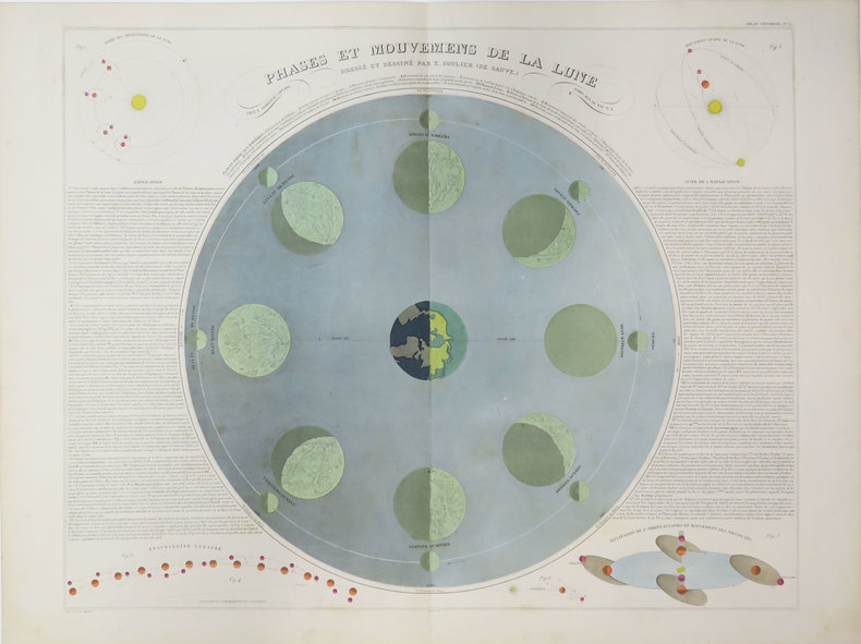
SOULIER (E.) & ANDRIVEAU-GOUJON (Eugène).
[LUNE] Phases et mouvemens de la lune. Dressé et dessiné par E. Soulier (de Sauve).
Paris, E. Andriveau-Goujon, 1889. 469 x 669 mm.
Bookseller reference : LBW-3523
|
|
|
SOUTH-AMERICA - JAILLOT, HUBERT/ BRION DE LA TOUR.
Amerique Meridionale divisée en ses Principales Parties au sont distinqués les une des autres Les Estats suivant Francois, Castillans, Portugais, Hollandois. Revüe et Corrigée par Mr. brion.
A Paris, chez le Sr Desnos, 1783. 46x64 cm. Engraved map of South America, contemporary handcoloured. The 2 large cartouches uncoloured. Right margin shaved, small tear showing into scale, of which a small part lost (1x1 cm.).
Bookseller reference : 25418
|
|
|
SOULIÉ, Docteur Frédéric
LES CONSEILS DU VIEUX BRIDGEUR
Paris Edité par Les Laboratoires Pépin Leboucq / Draeger, Imp. Sans date in 12 (18,5x13,5) 1 volume broché, couverture illustrée, 64 pages, avec des illustrations en couleurs. Bon exemplaire ( Photographies sur demande / We can send pictures of this book on simple request )
Bookseller reference : 27889
|
|
|
South Africa - Südafrika
Ephemera. Konvolut in 11 Teilen.
Johannesburg, 1940-1958. Das Konvolut bestehend aus 4 geografischen Karten: Map of Cape Town, 1948 / Tourist Map of Johannesburg,1951 / Map Your Holiday in South Africa (2 Ex.) und aus 7 Broschüren: Visit the Home of the White Rhino, Historic Pretoria, Sauk, Heart Vol. 4, 1949, Reports on the State of South Africa, 1958, South Africa - Land of Contrast, Pretoria. Good condition.
Bookseller reference : 24914

|
|
|
SOUTH DEVON & DARTMOOR.
Map of South Devon and Dartmoor, compiled from the Ordnance Survey shewing River, Road and Railway, distinctly defined and coloured. [Scale Two Miles to an Inch.] A RARE SURVIVAL
8vo., folding coloured map on cloth measuring 20 x 30 inches (approx. 51 x 76 cms) folding in 21 panels to 7 x 4.5 inches (approx. 18 x 12 cms), some mild age-soiling and a few small annotations; patterned cloth boards, upper board with printed paper label, backstrip frayed else a sound copy. Locally published version of W.H. Smith's Reduced Ordnance Survey map. EXTREMELY SCARCE IN THIS CONDITION.
|
|
|
South Pacific Maps Pty Ltd
Pacific Ocean Hema Maps International
Hema Maps Pty.Ltd. Used - Good. Shows some signs of wear and may have some markings on the inside. Hema Maps Pty.Ltd unknown
Bookseller reference : GRP113954682 ISBN : 1875610022 9781875610020
|
|
|
SOUTH-AMERICA - JAILLOT, HUBERT/ BRION DE LA TOUR.
Amerique Meridionale divisée en ses Principales Parties au sont distinqués les une des autres Les Estats suivant Francois, Castillans, Portugais, Hollandois. Revüe et Corrigée par Mr. brion.
A Paris, chez le Sr Desnos, 1783. 46x64 cm. Engraved map of South America, contemporary handcoloured. The 2 large cartouches uncoloured. Right margin shaved, small tear showing into scale, of which a small part lost (1x1 cm.).
|
|
|
Southerland Henry DeLeon Jr. and Jerry Elijah Brown maps by Charles Jefferson Hiers
The Federal Road Through Georgia the Creek Nation and Alabama 1806 - 1836
Tuscaloosa AL: The University of Alabama Press 1989. First edition. Hardcover in full cloth. Very Good in Very Good dust jacket. Octavo standard size. Slight wear to edges and corners of dj and boards. 198 p. w/ maps illustrations notes bibliography index. A useful study of the Federal Road its construction its impact on First Nations peoples primarily the Creeks and pioneer movement westward and its demise. <br/><br/> The University of Alabama Press hardcover
Bookseller reference : 12840
|
|
|
Southern France Map Michelin Maps French Edition Pneu Michelin Firm Firm
Southern France Map Michelin Maps French Edition Pneu Michelin
Fair. Map is generally clean and all fold lines appear to be in good shape. Notes on back or front depending on your point of view. Creased edges. should have images unknown
Bookseller reference : DM-SJTC-WZZ9 ISBN : 2067009192 9782067009196
|
|
|
Southern Pacific Company
Map of San Francisco: Showing points of special interest to attendants the Fifth International Convention of the Epworth League July 18-21 1901
<p>Map of San Francisco: Showing points of special interest to attendants the Fifth International Convention of the Epworth League July 18-21 1901 folding map of 21" x 28" printed in black & red.With numbered locations of places of Methodist interest and historical. Verso of map with 23 panels detailing trips excursions to Yosemite Valley Southern California including Pasadena Redlands Riverside Palo Alto Santa Cruz Lick Observatory. Very good minor wear; short tears at folds.</p><p>San Francisco before the 1906 devastating earthquake.</p> unknown
Bookseller reference : 2221875

|
|
|
Southern Pacific Company
Map of San Francisco: Showing points of special interest to attendants the Fifth International Convention of the Epworth League July 18-21 1901
<p>Map of San Francisco: Showing points of special interest to attendants the Fifth International Convention of the Epworth League July 18-21 1901 folding map of 21" x 28" printed in black & red.With numbered locations of places of Methodist interest and historical. Verso of map with 23 panels detailing trips excursions to Yosemite Valley Southern California including Pasadena Redlands Riverside Palo Alto Santa Cruz Lick Observatory. Very good minor wear; short tears at folds.</p><p>San Francisco before the 1906 devastating earthquake.</p> unknown books
Bookseller reference : 2221875
|
|
|
Southwell R. V.
RELAXATION METHODS IN ENGINEERING SCIENCE
Oxford: Oxford at the Clarendon Press 1951. pp. vi ii 252; b/w illustrations fold-out plans. Original dust jacket very good slightly marked with a little rubbing to edges spine with some toning and slightly chipped to the head price-clipped and repriced by publisher now attractively presented in a loose-fitting clear archival sleeve. Hard-back binding very good. Contents clean and tight previous owner's initials to the front end paper otherwise unmarked no foxing. A very good clean copy. Reprint. Hard Cover. Very Good/Very Good. 8vo. Oxford at the Clarendon Press Hardcover
Bookseller reference : 019367

|
|
|
Soviet Union Information Bureau.
THE SOVIET UNION. Facts. Descriptions. Statistics.
288p. + Plus two color folding maps. Decorated title page. Lacks first endpaper. 8vo. Original full red cloth binding, stamped in gold. Original dust jacket, very slightly worn with a few tears but no loss. With mimeographed sheet listing the Council of People's Commissars of the Soviet Union as of February, 1932. First American edition. Coldwar/Economics 7
|
|
|
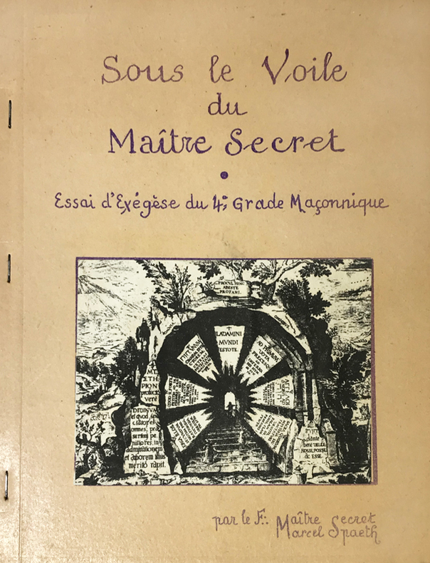
Spaeth (Marcel) :
Sous le Voile du Maître Secret. Essai d'Exegèse du 4e grade Maçonnique. Par le F.: Maître Secret, Marcel Spaeth.
Rueil-Malmaison, Marcel Spaeth, s.d. (circa années 1960) ; in-4, broché agrafé sur le côté, polycopié de 53, (3) ff. de planches, couverture beige illustrée, titre indigo reproduction d'écriture, (1) f. de papier bleu en frontispice, nombreuses figures, texte recto.
Bookseller reference : 14763
|
|
|
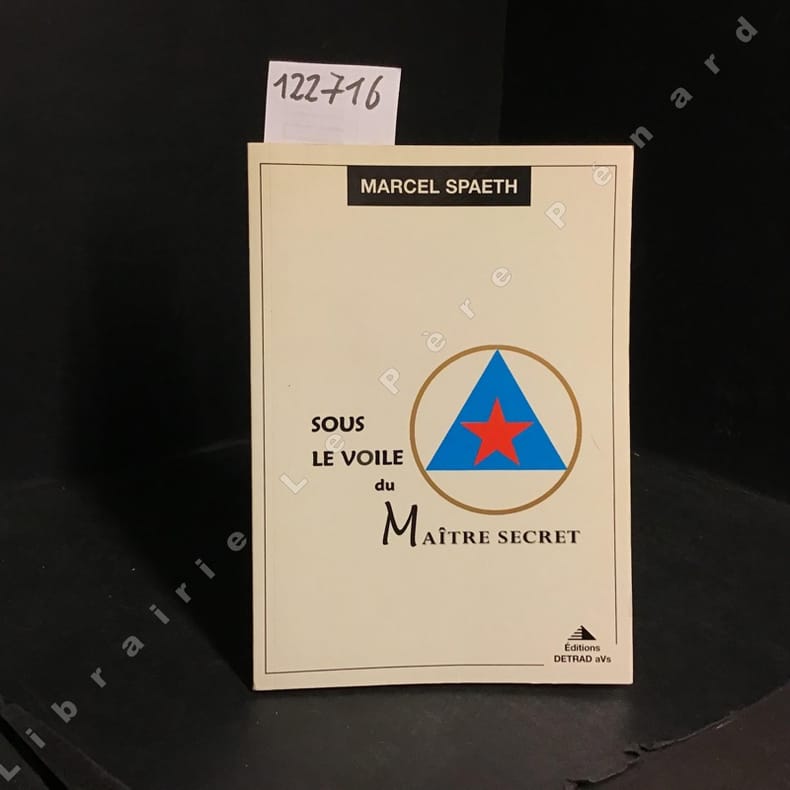
SPAETH, Marcel
Sous le Voile du Maître secret
1995 Editions Detrad aVs - 1995 - In-8, broché - 100 pages - Nombreuses illustrations en N&B, in et hors-texte, dans l'ouvrage
Bookseller reference : 122716
|
|
|
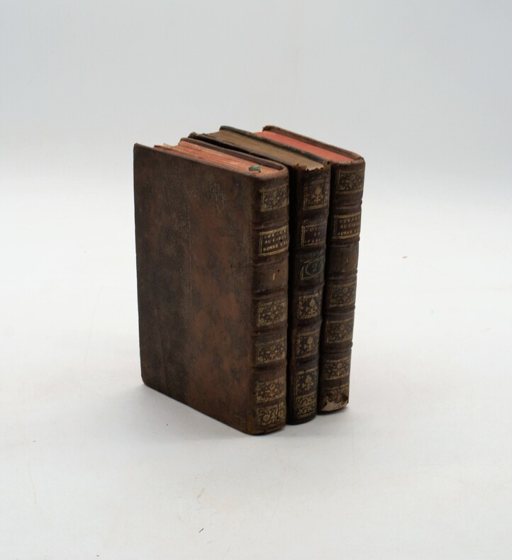
SPARRMAN ,André
Voyage au Cap de Bonne-Espérance, et autour du monde avec le capitaine Cook. et principalement dans les pays des Hottentots et des Caffres.
Paris, Buisson, 1787. Trois volumes in-8 (198x120mm), veau marbré de l'époque, tranches marbrées, dos à nerfs ornés avec pièce de titre (rouge ) et tomaison (vert) mouillure au t2 . Première édition française en format in-8. Une carte dépliante et 16 planches.
Bookseller reference : PHO-715
|
|
|
SPARRMAN (Anders)
Voyage au cap de Bonne-Espérance, et autour du monde avec le capitaine Cook, et principalement dans le pays des Hottentots et des Caffres.
À Paris, chez Buisson, 1787, in-8, 3 volumes, XXXII-388pp-366pp-363pp , illustré de 16 gravures (6 en répétition) , relié plein cuir marbré époque , dos à nerf orné avec pièce de titre , dos du tome 2 différent , accident aux coiffes , 1 planche détachée , fente intérieure tome 1.
Bookseller reference : PHO-1121
|
|
|
SPARRMAN
Voyage au Cap de Bonne-Espérance et autour du monde avec le capitaine Cook, et principalement dans le pays des Hottentots et des Caffres
Paris, Buisson, 1787. 2 vol in-4° (26 x 20 cm) , 2ff.-XXI-3pp.-478pp.[2] ff., 2ff.-462 pp., illustré d’un frontispice, une carte et 15 planches, relié plein basane époque, dos à nerfs orné avec pièces de titre et tomaison vertes, triple filets aux plats et roulette intérieure, tranches marbrées, coiffe sup. réparée, tache au coin, travail de ver (tome 2) sur 15 feuillets, 2 cahiers brunis, petite mouillure marginale.
Bookseller reference : PHO-1778

|
|
|
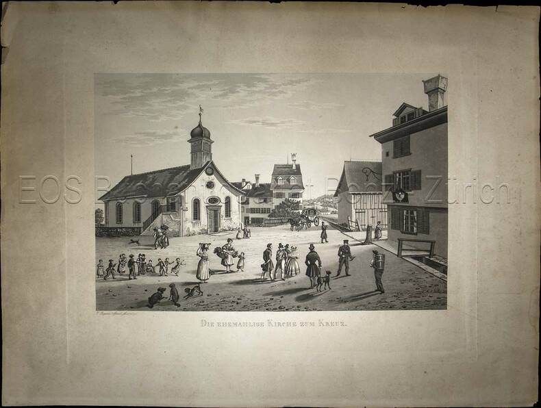
Sperli, Johann Jakob (1794-1843):
Die ehemahlige Kirche zum Kreuz.
(1838). Aquatinta, gezeichnet und gestochen von Johann Jakob Sperli d. Ä. Blattgrösse: 40 x 53 cm. Plattengrösse: 31 x 40 cm. Bildausschnitt: 23,2 x 34,5 cm.
Bookseller reference : 845CG
|
|
|
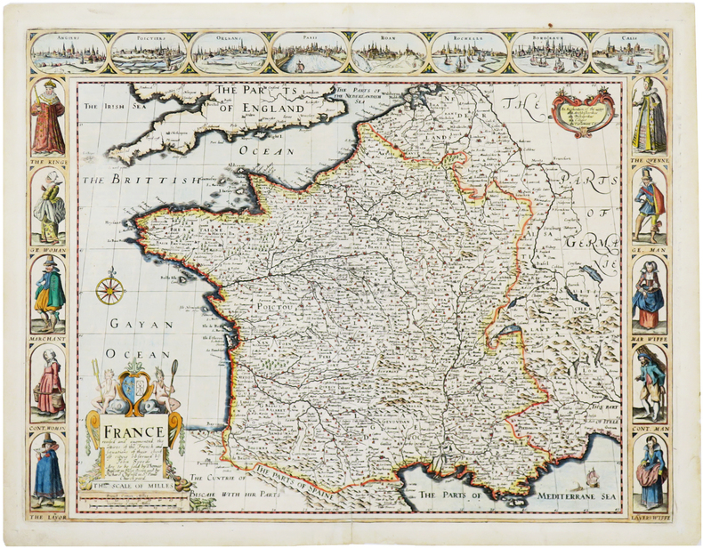
SPEED (John).
France revised and augmented, the attires of the French and situations of their cheifest cityes.
Londres, Thomas Bassett and Richard Chiswell, [1676]. 402 x 522 mm.
Bookseller reference : LBW-7057
|
|
|
SPEED, JOHN.
John Speed's England. A coloured Facsimile of the Maps and text from the Theatre of the Empire of Great Britaine. First Edtion, 1611.
London, Phoenix House Limited, (1953-54). Folio. 4 orig. hcloth, all in orig. slicase. Fine and clean. Text and fine facsimile-maps in colour.
Bookseller reference : 49146
|
|
|
Speed, John
Shropshyre Described: The Situation of Shrowesbury Shewed with the Armies of Thos Earles, and Other Memorable Things Observed
Undated facsimile reprint of map of Shropshire originally issued in the early 1600s. eng
|
|
|
SPEED, JOHN.
John Speed's England. A coloured Facsimile of the Maps and text from the Theatre of the Empire of Great Britaine. First Edtion, 1611.
London, Phoenix House Limited, (1953-54). Folio. 4 orig. hcloth, all in orig. slicase. Fine and clean. Text and fine facsimile-maps in colour.
|
|
|
Spencer, Brian
A Visitor's Guide to the Lake District (revised edition)
No marks or inscriptions. A lovely clean very tight copy with bright unmarked boards and no bumping to corners. Dust jacket price clipped but not marked or torn or creased. 139pp.

|
|
|
Sperli, Johann Jakob (1794-1843)
Die ehemahlige Kirche zum Kreuz.
(1838). Aquatinta, gezeichnet und gestochen von Johann Jakob Sperli d. Ä. Blattgrösse: 40 x 53 cm. Plattengrösse: 31 x 40 cm. Bildausschnitt: 23,2 x 34,5 cm. + Wichtig: Für unsere Kunden in der EU erfolgt der Versand alle 14 Tage verzollt ab Deutschland / Postbank-Konto in Deutschland vorhanden +, Abb.
Bookseller reference : 845CG

|
|
|
Sphyroeras Vasilis & Avramea Anna & Asdrahas Spyros
Maps and Mapmakers of the Aegean
Athens: Olkos Publishers 1985 New - will be sent to you direct from the publisher in GreeceTranslated by G. Cox J. Solman. The charting of the Aegean Sea or the Greek Archipelago from the 15th up to the 19th century. 236p. Map Index; General Index. 166 color and black & white maps. 1st Greek Edition. Hard Cover. Fine/Fine. Olkos Publishers hardcover
Bookseller reference : 28012
|
|
|
Sphyroeras, Vasilis & Avramea , Anna & Asdrahas, Spyros
Maps and Mapmakers of the Aegean
Translated by G. Cox, J. Solman. The charting of the Aegean Sea, or the Greek Archipelago, from the 15th up to the 19th century. 236p. Map Index; General Index. 166 color and black & white maps Book
|
|
|
Sphyroeras, Vasilis & Avramea , Anna & Asdrahas, Spyros
Maps and Mapmakers of the Aegean
The charting of the Aegean Sea, or the Greek Archipelago, from the 15th up to the 19th century. English translation by G. Cox & J. Solman. 236p. Map Index; General Index. 166 color and black & white maps Book
|
|
|
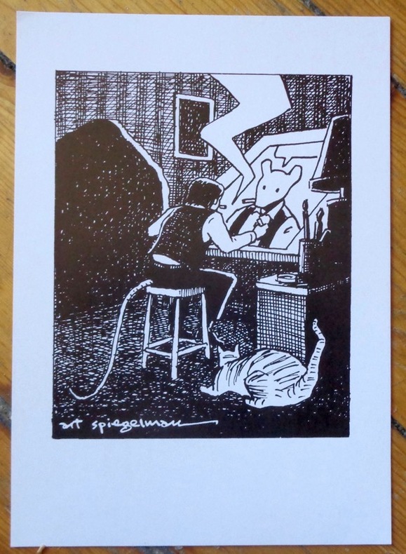
Spiegelman Art:
Self portrait.
Basel, Comix Shop, 1997. Carton d'invitation (auf Deutsch, au format 15 x 21 cm.) au vernissage de l'exposition "Art Spegelman - Prints".
Bookseller reference : 9049
|
|
|
Spiegl Fritz
FOUR CENTURIES OF LIVERPOOL The Growth of a City A Collection of Maps and Views
Liverpool: Scouse Press 1970. This is the revised "Liverpool Packet No. 2" with the additional maps. Numerous maps and plans - all present and correct- checked against contents list some colour and many folding printed on different colour papers historical notes also present. In original plastic wallet which is a little worn and marked. The title page is faded and has a number written to the reverse otherwise no other marks or inscriptions to maps or notes. Some maps with small creases to corners and some a little browned along edges. A good to very set. 2nd Printing. Paperback. Very Good. 4to. Scouse Press Paperback
Bookseller reference : 007181
|
|
|
SPK.
[PROPAGANDE SECONDE GUERRE MONDIALE] Confiance... ses amputations se poursuivent méthodiquement.
[entre 1941 et 1942]. Affiche en couleurs de 114,5 x 75 cm.
Bookseller reference : LBW-8634

|
|
|
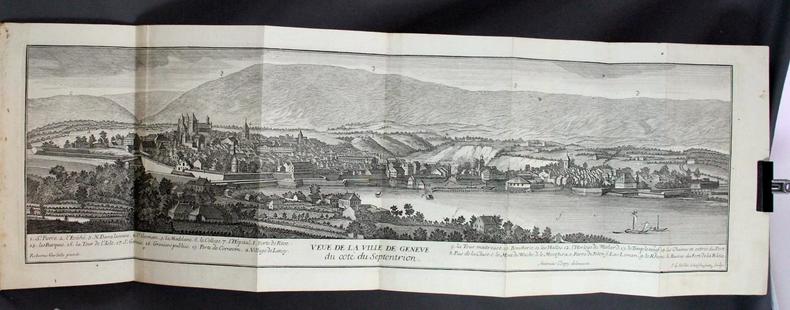
SPON M:
Histoire de Genève. Rectifiée & augmentée par d’amples Notes. Avec les actes et autres pièces servant de Preuves à cette Histoire.
A Genève, Chez Fabri & Barrillot, 1730. 2 volumes in-4 de XV-556-[10], 518 pages + 2 grandes planches dépliantes et 1 carte. Plein veau marron moucheté, dos à nerfs ornés de fleurons et roulettes dorés, pièces de titre et tomaison de maroquin havane, tranches rouge.
Bookseller reference : 2358
|
|
|
SPON [Jacob]; [GAUTIER Antoine (notes)]:
Histoire de Genève. Rectifiée & augmentée par d’amples Notes. Avec les actes et autres pièces servant de Preuves à cette Histoire.
A Genève, Chez Fabri & Barrillot, 1730. 2 volumes in-4 de [4]-XV-556-[2] et [8]-518 pages, plein veau brun, dos à 5 nerfs ornés de fleurons, roulettes. Exemplaire non rogné, reliure pastiche moderne.
Bookseller reference : 21028

|
|
|
Spofford, Jeremiah.
A GAZETTEER OF MASSACHUSETTS: Containing a General View of the State, with an Historical Sketch of the Principal Events From Its Settlement to the Present Time, and Notices of the Several Towns Alphabetically Arranged. With a Map of the State.
348 p. Folding colored map of Massachusetts. The map could use some minor repairs at folds, etc. 12mo. Contemporary full leather binding. American Imprints 35374; Howes S-839; Sabin 89563. Atlas Case. QUITE SCARCE. **PRICE JUST REDUCED!
|
|
 Receive by email
 Download as PDF document
 RSS feed


